Sunday, August 30, 2020

Show Low Part 3

Map of this blog's locations click this link to open the map

We’ve been here at Juniper Ridge for 11 weeks already. While we wouldn’t typically stay at this type of resort, it has definitely filled the bill for what we were looking for during these uncertain times. Other than playing a little bit of pickle ball, we really haven’t taken advantage of the other activities the resort offers. Of course, many of the normal events that happen each summer have been cancelled. But I get the sense that many of the folks living here normally have a full summer of things to do. For the most part there isn’t much turn over of people at the sites - nothing close to a private campground or state park. But that doesn’t mean there are no new residents arriving from time to time. The two sites immediately to our north have both had a couple different people in them over the months. Each site has a large shade structure that make for a challenge when getting a rig into them. The site two down from us also has a row of pine trees making the entrance even more difficult. We have watched three rigs over the months come and go in that site. A fifth wheel and a travel trailer each took over an hour to get the rig in. While a larger class A motorhome spent at least that long, nearly got in a position where it couldn’t get in OR out and finally gave up before they damaged their rig. So I guess there can be some excitement in the resort!

About five miles from our spot is the Silver Creek Hatchery. We usually enjoy checking these types of places out when we get a chance so we headed over to investigate. Unfortunately the actual hatchery is not open to the public except by appointment only. But there is the actual Silver Creek that runs thru the property and a trail that more or less follows the meandering creek. There is a reasonable sized parking lot and a dozen vehicles parked there. It didn’t seem likely that all these people were here to do the short hike and we quickly discovered that they are all here to fish. Silver Creek didn’t really look like a good fishing spot to us. It is probably only 15 to 25 feet wide and doesn’t look very deep. We start to walk east along the trail and after a couple hundred feet, we get away from the crowd.

A Calm Silver Creek

Continuing Along Creek

A Bit Wider

About a mile out from the parking lot, we hit the end of the trail. At least the legal portion of the trail. We had read that there would be signage to signify where the public is not permitted and there was little doubt when we reached that point. There even appeared to be a trail camera keeping a look out for possible intruders. There was no sign of any hatchery building beyond the barbed wire so it didn’t seem like we were that close (later a look on Google Earth shows a building another half mile away). Just seems like a little over the top for a fish hatchery. We turn around and enjoy the scenery on the walk back to the car.

I Don't Think They Want Us to Go Any Further!

Cool Damselfly

Stump for a Seat

The next day was going to be another hot one so we decided to head to the town of Greer for some hiking. Why Greer? It’s in the heart of the White Mountains (Arizona not New Hampshire) and the Apache-Sitgreaves National Forest. The town is at an elevation of 8300 feet but much of the hiking will go well over 9000 feet so it will be dramatically cooler there. It’s not super close - about a 60 mile drive or 80 minutes southeast of us. We don’t have any long hike planned but figure to do a few shorter hikes to get a sense of the area. Our first hike, the Spring Tank Trail, starts out in a residential area of Greer just north of town. Calling it a residential area might be a stretch. Think more like cabins in the woods. I suspect 90% of the residents only come here to escape the summer heat from places like Phoenix.

We find a wide section of the road to park near the trailhead and start up the trail. Its heavily wooded and the trail is in good shape. In just about a half mile we come across the namesake for the trail - Spring Tank. We’ve noticed that here in Arizona there are many bodies of water that are called tanks. I’m not positive of the distinction between a tank and a pond but in my estimation they seem to be the same thing. We have a geocache to find nearby and it turned out to be hidden about 120 feet from the posted location so we were in the area overlooking the tank for some time.

Spring Tank

View Above Spring Tank with Chris Waiting to Go

We continue up the trail and find it to be much steeper and given we are at almost 9000 feet, it’s a slow go.  We knew there was a forest road up top where the terrain flattens out so we continue up the additional 3/4 mile to the road. I was able to convince Chris we should go look for a geocache hidden down a gully on the far side of the road that hadn’t been found in over three years! It took some time to negotiate the large boulders and find the well hidden cache. We hadn’t planned on spending two hours for just over a 3 mile hike. But it did include two challenging caches and 800 feet of elevation change.


Spring Tank Track

We then continue into Greer proper. It’s a small town with a few businesses and cabin rentals that must cater to the part time visitors. I suppose it may also be a winter destination for those that like those activities. The town is rather isolated because it is five miles off State Route 260 on basically a dead end road. We go to the end of that road to find a small parking lot that gets us to our next trail. We sit in the parking lot and eat lunch while a brief rain shower passes over us. We are overlooking a small creek with a few people out trying their hand at fishing. I’ve come to discover that this little creek has a name that is nearly as long as the creek is wide - West Fork Little Colorado River. We finish lunch and find the makeshift walkway over the creek.

Chris Made It Across the Colorado River (Little West Fork Version)

Our goal for this hike was one named the Amberian Loop. At 2.2 miles and just under 700 feet of elevation, it’s supposed to offer great views of town. About 0.4 miles up the trail is a split where the actual loop starts. We had read online comments from previous hikers that taking the left at the sign and doing the loop in a clockwise direction was preferred. We start to get some amazing views after shortly after the turn.

Take the Left for Better Marked Trail

Overlooking Greer AZ

As we get near the top of the hike we are on a bit of a mesa or plateau at almost 9100 feet. Most of the trees are burned and the terrain is quite rocky. Staying on the trail becomes a challenge. There are small markers on the trees and generally we can spot the next marker as we pass each one. We do notice that there are no markers on the back side of the trees. This would explain the comments about the trail not being marked. We eventually get back to the more substantial trail. It continues south on the mesa but we turn right and head north back to the car.

Burned Out Trees at Top of Mesa

Better Marked Trail

After a quarter mile or so we find another marked trail on our left. We don’t have it on our GPS but wonder if it is an alternative route back down to the car. It turned out to have a great view of the valley south of Greer, but didn’t appear to be heading in a direction that would get us back so we enjoyed the view and then continued on the loop to the car. Our detour added about half a mile to the hike but all in all, it was a pleasant hike with great views.

Valley View

Another Valley View


Back to the River

Amberian Loop Track

Our two hikes had gotten us in 6 miles and even though we had another hike in mind, our legs told us otherwise. On the way out of town we spot a nice looking campground- Rolfe C Hoyer Campground. It’s a forest service campground without utilities but does have a dump station and potable water. From the looks of things, at least some sites are large enough for a rig our size. Could be an convenient place to stay in the future so we could be close to the many other hiking opportunities in the immediate area. We instead head down to check out some of the small reservoirs opposite the campground. Both Tunnel Reservoir and River Reservoir have water in them but they level seems to be quite low especially based on the large concrete boat ramp that doesn’t quite reach the water! This was a fun, if tiring, day trip and must consider coming back.

Boat Ramp at Tunnel Reservoir Doesn't Reach Water

A Part of River Reservoir

A few weeks ago while hiking the Los Burros Trail, we saw a side trail and fire road up to a fire tower. It was late in that 10 mile hike and didn’t have the energy to add it on. So we headed back in the middle of August to get in another hike and beat the heat somewhat. The fire tower is at Lake Mountain and is at 8500 feet. We start out on the  Los Burros Trail for about half a mile before hitting FR 269. The trail up to the fire tower is just a few hundred feet further but we decide to hike the the fire road with the plan on hiking back down the trail. It’s a slow steady climb to the tower gaining nearly 400 feet elevation.

Heading Up FR 269 to Lookout Tower

We did a brief diversion to a geocache in the middle of the woods on our way up and found a faint trail that got us up top. The 49 foot tall tower was built in 1926 and looks in good shape for being nearly a century old. A truck was parked nearby and we were quickly greeted by a voice from the tower. Apparently it’s a fire tower that is still in use. That may explain the well maintained appearance. The guy up top was quite friendly and talkative. Possibly because he doesn’t get a lot of visitors. He seemed surprised by our approach until we told him we had gone for a geocache. He told us there was another one at ground level on the opposite side of the tower. As we started to look, he seemed to think we needed some help and gave us a few hints until we spotted it hidden under a rock.

Fire Tower with Lookout Guy Chatting with Us

Just before we had gotten to the tower, we had heard a clap of lightning and wondered if we might be getting wet before we make it to the car. Our tower friend had a much better view of the weather and told us it appeared to be heading a different direction and we would likely stay dry. There were a lot of trees around the tower so there isn’t a great view except for one opening right near where an Adirondack chair was setup. We head back over to the main trail back down which first heads past the lake. It’s not a very big lake (more like a pond or even a tank!) but I suspect it is much larger come spring.

Partial View from Lake Mountain Lookout

Not Much Water in the Lake

The hike back down the trail was pretty easy. In the distance we could hear gunshots - probably some locals out target practicing. It was hard to tell how far away they were but at times it seemed like we were going to be walking into the line of Fire. As we got further down the mountain, we ran into a few of the open range cattle. Most of them didn’t bother to give us more than a passing glance. But there was one black one with a few white spots on its head that seemed to keep a wary eye on us the whole time we passed by. I can only assume he was designated guard cow for that day. We made it back to the car with it still looking like it might rain but never did. After eating lunch we headed out but did one short walk for a geocache not far off the Chipmunk Springs Trail. We had mountain biked the opposite end of this trail a few weeks earlier and from what we could see, we would have enjoyed the ride all the way to Los Burros.

Intently Watching Us Pass

Definitely Looks Like Bad Weather

Our Fire Tower Track Near Los Burros


At the Edge of the National Forest

Another woodworking project I tackled while I have access to a decent shop was to make some small tables for outside with our camp chairs. I had an idea of the design I was looking to create so I spent some time on the web searching for plans I liked. I hadn’t found a good lumber store in the area so I decided to make them out of cedar. It’s a fairly lightweight species and does well in the elements. Plus typical big box hardware stores carry cedar. I spent quite a few hours at the shop but eventually got three of them constructed. Once built, Chris did the time consuming part of clear coating them. Hopefully they will hold up for many years worth of drinks and snacks while sitting outside.

Cedar Folding Table

Me, Myself and I Show How Table Opens

Chris was looking for something different to do in the area and discovered a winery while searching online. I remember the first time I heard about a winery in Arizona and questioned how the heck they manage to grow grapes here. Having lived in the Finger Lakes region of Upstate NY, I had an impression of what soil and climate would be needed for growing grapes - and Arizona didn’t fit the mold. But we have visited wineries in Sonoita and Page Springs AZ over the years so we figured why not give the town of Concho a try. 

We haven’t really explored the area northeast of Show Low so we found a few other sights along a loop that would take us past the winery. Our first stop would be at the Wenima Wildlife Area just north of the town of Springerville. This is another example of a place that likely goes unnoticed even to locals. It’s not shaded green on maps to signify its existence. Even though there is a sign off the main road, the landscape at the turn off is not very impressive. It’s mostly flat dry grassland. But like often is the case, a geocache hidden at Wenima highlighted the place’s existence. The first mile on the dirt road makes us wonder what could be back here. But by 1.5 miles, we have dropped a couple hundred feet and have come upon a small and lush green area next to the Little Colorado River. 

View of the Colorado River at Wenima

We find the geocache hidden near a small picnic area shaded by a large tree. There is a trail that follows along the river but much of the plant growth is tall enough to block the view of the water. We do a short walk along the trail and come back thru what looks to be an irrigated plot of land with thousands of sunflowers. It’s a pretty stop worthy of the hour it took us to check out.

Geocache, Picnic Table and Trailhead Combined

Another River View

Field of Sunflowers

The next stop is just 15 miles north on Route 180. Lyman Lake State Park has a campground and your typical state park fare: picnic shelters, hiking trails, etc. But the big draw for most visitors is the 1500 acre lake the park encompasses. It’s created by damming the Little Colorado River. We hadn’t bothered to get an annual Arizona state park pass since there aren’t many others in the area. It’s only $7 to get in and worth the price. Being a weekend, the place was crowded but not packed. The camping area looked nice with some trees but this area is rather barren. We pick a shelter near the visitor center overlooking the lake to eat lunch before heading out for a hike. 

Lunch View

The Peninsula Petroglyph Trail is a little more than a mile long and is pretty descriptive. It’s on a peninsula and there are petroglyphs. There is both a lower loop and an upper loop. Up top we are over 100 feet above the water level. There is no shade to speak of. Although we found a couple of huge ravens that had found a bit of a rock overhang to get out of the sun. The actual petroglyphs are easy to spot but aren’t the best we have seen in our travels.  From this vantage point, it’s easy to see the size of the campground and it did look to be full. They also permit dry camping along a section of the shoreline. Looks like fun to be able to walk 50 feet from your rig to the cooling waters. 

At Trailhead

Lyman Lake from Above


Ravens Beating the Heat

Petroglyphs

Campground

Beach Camping

Next we drive out the dirt road to Rattlesnake Point. None were spotted as we walked around the old Pueblo ruins. Only a few of the estimated 80 to 90 rooms are excavated and exposed. Some rooms have been excavated, investigated and the filled back in to preserve them. A shelter has been built over the exposed rooms to help preserve them from the elements. I need to remind myself that while it looks like a decent place with the nearby lake, this lake didn’t exist back in the mid 1300’s when the place was occupied. 

Exposed Pueblo Rooms

YIKES!!!

Our next stop is the Red Rock Vineyards in Concho. Chris had picked this one because there is also a lavender farm associated with the winery. Of course being this late in the summer, all the lavender had been harvested. We stopped in for a wine tasting. A group of 8 had just left, so we had the place to ourselves. The wine was okay but we are dry wine lovers and most of the ones they have to sample are rather sweet. We drive back thru Snowflake AZ getting a few geocaches along the way. One was near a ranch where the barb wire fencing used a unique mounting technique with horseshoes welded to the poles.

Entrance at Red Rock

Garden Are at Winery

New Grape Vines Just Planted

Lavender Field

Praying Mantis and Reflection

Interesting Barb Wire Mounting Method

One afternoon while sitting outside, I noticed hummingbirds at our neighbor’s feeder. I get out the long telephoto lens and wait for them to come back. They are definitely fascinating to watch. Here are the best shots I got.


Saturday, August 8, 2020

Show Low Part 2

  Map of this blog's locations click this link to open the map

We’ve stayed in Arizona enough to realize the state does not observe Daylight Savings Time (with the exception of the Navajo Nation). Normally we would be heading out of the state for cooler weather early enough in spring that this fact wouldn’t really impact us. However with us staying here for the summer, we really notice the lack of DST. I was pretty young when it was first enacted so I guess I have just become accustomed to longer daylight in the evening and a reasonable time for sunrise. In Show Low, sunrise is at 5:08 AM and sunset at 7:35 PM at the summer solstice! It turns out our next door neighbor is the early bird and with her washer and dryer in the shed a mere 15 feet from our heads, we have been pulled out of sleep by the humming of the washing machine very early some mornings.

We discovered there are a couple of decent disc golf courses in the area. The one in Pinetop-Lakeside is at Mountain Meadows Park. It isn’t completely wooded so we do reasonably well. Like so often is the case when playing a new course, the biggest challenge is figuring out the sequence of the holes. The 18 holes of this course are laid out in a relatively small area so we sometimes need to walk to the basket just to confirm which one we are aiming for. Another course is at the town park in Show Low. This course is much more spread out so there is less confusion about which basket is the correct one. The park also has a ball fields, tennis courts and playground equipment that the course need to work around. The biggest problem with this course is how heavily treed it is. I don’t think any trees were irreparably harmed during our play but quite a few were hit!

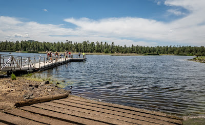
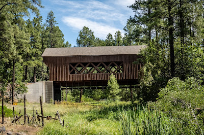
Another hike we went on was at Woodland Lake Park. This park is adjacent to the disc golf course in Pinetop-Lakeside. We parked along Woodland Road and started out on the Big Springs Trail. There was a neat covered bridge that heads back to a gated community so we couldn’t explore it close up. There were multiple geocaches that helped us pick which trails we would take. Like all the other trails in this area, signage is exceptionally good so getting lost wasn’t really an issue. We eventually work our way down to Woodland Reservoir. This area is much more crowded with a few kayakers out enjoying the weather. A small scale covered bridge is part of the paths around the lake.
Private Covered Bridge

Dock at Woodland Lake

Small Covered Bridge by Woodland Lake

Coot with Two Juveniles


After circling the lake, we headed up the Hitching Post Loop to lead back to the car. Along the trail, we could hear a large crowd and continual Jimmy Buffet music - I could hear Chris singing along behind me. We never did see exactly what was taking place but it didn’t sound like something we might expect during a Covid times. We did a slight detour for another cache near a Nature Center. There was a pretty pond near the cache with a mother duck and her 5 young ducklings near the shore.

Heading on Hitching Post Trail

As we were enjoying the serenity of the location, a young couple approached with their dog. It saw the ducks and made a beeline for them. The next 90 seconds was somewhat incredible to watch.  The mother duck, seeing this 25 pound dog heading her way, got the ducklings to go into the reeds along the shore while it started to swim the opposite way. It seemed to be making sure the dog was chasing her and not her children. The water wasn’t super deep so the dog could sometimes run while other times swim. Mom duck led the dog a good 100 yards away all the while, the dog owner chasing the dog along the shore trying to get it to stop. Once the duck felt the dog was no threat to the ducklings, it simply flew back over to find them safe and sound. Our route turned out to be 5.5 miles and was quite enjoyable.

Mom and 5 Ducklings

We decided to give the Maverick Trail another try. This time we headed about 10 miles from camp to a trailhead along alone Pine Dam Road near Burton Road. We were going to head west on the trail until it intersected Burton Road again figuring it to be in the 4 to 5 mile range. It’s a bit confusing at this trailhead since the trail seems to be going either north or south. We head south and shortly turns to the southwest. This part of the Maverick Trail was excellent. Not too rocky or many sections with loose dirt. Much of the ride was gently rolling and was a rather pleasant bike ride.

Well Marked Trail

Another View From Trail

Rolling Hills

There is a fairly steep hill about half a mile before we hit Burton Road again. While I found it rideable, I needed to stop frequently to catch my breath. My average speed up the hill was nearly the same as Chris’ speed walking while pushing her bike up. Once up top, there is a nice view. There is also a good downhill to get to the paved road. It was a bit eroded from water and ATVs but not too bad. Once on Burton Road, we headed south to look for another cache along the Ghost of the Coyote Trail. Okay, maybe I was just slightly curious about the trail’s name. It turned out this trail permits mountain biking but it is far from suitable for mountain biking. I ended up needing to walk the last the tenth of a mile while Chris stayed with the bikes. Sections of Burton Road while paved, have terribly wash boarding like you would find on a dirt or gravel road. It was the oddest thing. Along the way we pass a side road with a name worthy of stopping for a picture! The ride ended up being about 9.5 miles and was a pretty good combination of dirt trail and lightly traveled paved road.

View from Atop Hill

Rutter Trail Down Hill

Appropriately Named Road

Having seen what the trails were like in the vicinity of the Country Club Trail, we headed back over there with the mountain bikes to check them out some more. We started out on Forest Road 185 instead of the trail just because there were a few geocaches along the road we had not gotten yet. Being open range cattle area, there was a large corral with a ramp. I presume the cattle are rounded up by cowboys, placed in the corral and then loaded onto a truck. This one was metal and in good shape. We have seen others that seem to be beyond hope.

Ramp at Cattle Corral

We were planning on trying out the Chipmunk Springs Trail. We knew we would intersect it after a mile or so on the forest road. When I saw a trail to my right, I assumed we were there and turned. It took Chris awhile to catch up and inform me I turned too early. Back to the road and another 0.15 miles we spotted the correct trail. We crossed over a wet area (possibly the spring the trail is named for?) and found it odd to see such green vegetation growing in a mostly dry landscape.

Sign for Chipmunk Trail

Band of Green from Spring

The trail turned out to be excellent for biking. From our starting point it is a generally uphill ride but not noticeably steep or rocky. This trail actually leads to the Los Burros Trail we are hoping to hike in the near future although we don’t make it the full distance. But it did turn out to be a very pleasant 13 mile bike ride, especially the slight downhill be had most of the way to the car.

Pretty Singletrack in Woods

Fence Line Crossing

When we first arrived here at Juniper Ridge, one of the residents told us that we would like the weather - it would only get above 90 degrees on a few days. Of course, what they weren’t counting on was a record breaking heat wave that would hit the region. Phoenix had the hottest July on record this year and 34 days this summer with a high over 110 degrees! Of course, Show Low doesn’t experience that type of heat but we did stay in the mid 90’s most of the month. We generally have a wide temperature tolerance so we found only one afternoon where we turned on the air conditioning. From the sounds of it, our neighbors had theirs running most of the summer.

We did however make an addition to the motorhome to help things stay cool - window awnings. There have been many times where we thought awnings would be a wise investment to help keep the sun out. We took some measurements and placed an order in late June. A few weeks later, a big semi pulls up in front of our rig and dropped the package with the two awnings. We have one over the passenger side window and a second, large one on the two windows on the driver’s side. We went with the style that has a partial see through fabric that will block about 90% of the sunlight but let us see through them from inside. It’s a good compromise from the cave-like feeling that opaque awnings can give. Installation was pretty easy only taking us a few hours over three days to get up. We did need the assistance of one of our neighbors for the large one just because of the long and awkward nature of the awning. We could immediately feel the difference inside on the hot days. I’ve also found I am able to close them by reaching out the window from inside the rig.

Small Awning Closed

Small Awning Open

Large Awning Covers 2 Windows

The slower travel pace allowed us to get caught up on a lot of small, annoying issues on the rig that never seemed to rise to the level of being dealt with. One of our exhaust fans had developed a rumbling noise like a bad bearing but the motor really cannot be serviced. A replacement fan was ordered and turned out to be a very easy install. A month after going full time, I had clipped a wooden fence at a dump station and taken off the passenger side mirror. Surprisingly the thing didn’t get damaged from the fall and I had been able to reinforce the mounting holes and reattach the mirror. Of course the six pin connector that permits for mirror adjustment, mirror defrost and a right turn signal lamp had pulled apart. Since Chris doesn’t drive the rig, we had just manually aligned the mirror and lived with it. Now was the time to deal with it. Documentation was lacking so knowing which of the six wires on the mirror attach to the six wires on the motorhome was problematic. Fortunately as a former electrical engineer it wasn’t too difficult to identify which wire did which function. With a new connector and crimping tool ordered from Amazon, I had it put back together and working in a couple hours.

Another hike was along the Los Burros Trail located southeast of us in the Sitgreaves National Forest. It’s a bit of a drive to the trailhead with the last 8 miles or so on a gravel forest road. The main trailhead has a small primitive campground next to it but since the campground is closed for Covid, we have to go to a different spot to park. The full trail is 13 miles long - a bit longer than we wanted but there multiple options to shorten the loop to something more manageable. We started out on a very pleasant morning for the hike. Being at 8000 feet elevation helps with the temperature.

Starting Along Los Burros Trail

Scary Looking Insect

Odd Plant Along Trail

We had started south from our trail head and in 1.5 miles we are near the closed campground and find our short cut trail. In 1.6 miles we will be back on the main Los Burros Trail instead of the 5 miles the main trail takes to get to that same point. The trails are in great shape and it’s a very pretty hike. We could tell from the tracks that mountain bikers use the trail as well but we didn’t come across any. In fact, we saw only a few people in our total hike. Coming around Wishbone Mountain, we cross over the forest road again and considered walking it back to the car but it really didn’t appear to be a shorter route. By the time we made it to the car, we had gotten in 10 miles of hiking with about 1100 feet of elevation change - a tiring but nice hike.

Our Short Cut

Deer Intently Watching Us

Odd Trail Sign

Another Pretty Section of Los Burros Trail

Nice Clearing View

Los Burros Trail Track

One of the geocaches I had hidden in 2013 back in the Rochester NY area was a hand made cryptex (think the Da Vinci Code book/movie). In April of this year, the thing went missing. The friend that has adopted the cache could not find the device and didn’t have the ability to duplicate it. With the limited tools I had along, I too was not able to make a replacement. But now at Juniper Ridge, I have access to a workshop. I checked with the guys that run the facility to make sure they had no issues with me working on a project made mostly of PVC pipe and fittings and was given the okay. I tried to remember how I had created the first one and headed to the hardware store to pick up the required parts. It took quite a few visits to the shop over the course of a couple weeks to do the work. Fellow woodworkers in the shop initially were baffled at what I was making, but as it came together, they began to understand. The idea is that each of the six dials each have 8 letters and the dials need to be turned to spell out the proper word to have the device open. There are over 250,000 possible combinations although most of them are not real words.

Parts for Cryptex

Cryptex Completed

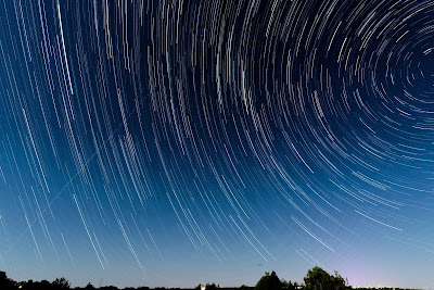
It was during this time that the comet NEOWISE was gracing our night skies. Of course, we were having a string of cloudy nights. When we finally had a clear night, we drove up the dirt road next to the resort to get a bit more darkness than we have from our rig. It took some time to be able to spot the comet but eventually did so. I came out a few nights later to do a time lapse session to see what a star trail photo of the comet would look like. Even though the comet was in the series of shots, it didn’t look any different than a normal star trail.

NEOWISE with 200mm Lens

NEOWISE with 500mm Lens

Star Trail

We took our bikes out for another section of the Maverick Trail. On our drive there, we stopped at a spot we had seen from State Route 77 many times and wondered what it was. A dirt road leads back the mile or so to an earthen dam. It’s over 100 feet tall and 800 feet wide - not a small amount of dirt and gravel. It apparently dams up Show Low Creek and forms Schoens Lake. Not sure how deep the lake is but based on the level of the spillway tower, the lake could get pretty deep. No water was flowing out the downriver side of the dam.

Schoens Lake with Spillway Tower in Foreground

Downstream Side

View Along Road from Dam

The starting point for the ride was the intersection of the trail with Pinedale Road and we intended to head west to the town of Clay Springs where the Maverick Trail starts/ends. Turns out the first mile of the trail more or less parallels the road and has a rather rocky (but dry) wash to walk the bikes across. Other than that initial stretch, it was a pleasant ride and we thought it was supposed to be nice weather as well.

View at Beginning of Ride


A few miles into the ride, we could see dark storm clouds forming and of course it looked to nearing Clay Springs. We pushed on but we intersected another trail. One way would go to Clay Springs and potential rain. The other way would head to a geocache about a mile north. We go with the easy call and head out for the cache. There were surprisingly more dirt roads back here than one might expect and we took the wrong one initially, but we eventually made it to the cache. The weather looked quite threatening so we decided to head back to the car and hope to stay dry. It wasn’t the planned ride but it was still a nice 12 mile outing.

Storm on Horizon


We had one more stop in the area and the rain seemed to be heading the opposite direction so we went to the town of Pinedale. We really only had one destination. An actual covered bridge. Supposedly the first covered bridge in the state. The town’s website states the bridge was built in 1976. So it’s not all that old. We found a picnic pavilion open at the closed town library and had our lunch before heading home. Based on the large puddles in the resort, the rain we saw had reached Juniper Ridge.

Pinedale Covered Bridge


Ever since Covid struck, I had been avoiding getting a haircut. For awhile, Arizona had closed all such businesses but they have been open for some time, but it just never seemed a safe decision. Initially I thought I might let it grow long and either go for a pony tail or a man-bun. But it got annoying well before I could pull either of those off. So Chris has taken up cutting my hair in the interim and am pleased with the outcome. Chris had last gotten her hair cut back at the end of December and was getting rather long. She surprised me one day and asked me to watch a YouTube video on how to cut women’s hair. Apparently her hair length had gotten past the point of her fear of me cutting it! So I watch the video of a flamboyantly gay guy explaining how to cut hair and sit Chris down in the chair and have at it. I think it turned out okay and Chris might even agree with that.