Map of this blog's locations click this link to open the map
We have definitely seen quite a few of Florida’s state parks over the years. Sometimes we stay at what are typically nice campgrounds while other times we spend a day hiking or biking some of the miles of trails they usually have within the park. Weeki Wachee Springs State Park sounds like many other of the state parks but it is about as unusual as they come. First is the location. Situated in Spring Hill Florida right along the very busy US Route 19 on the west coast of the state. It’s in one of the more congested parts of town - not a common location for a state park. But the most unusual aspect of the park is the major draw of the park. Not the springs or manatees or hiking trails but the Mermaid Show! Since 1947 this has been the site of the Newton Perry Underwater Mermaid Theatre.
 |
| Mermaid Theater |
We have driven past this place countless times having spent two winters in nearby Brooksville. It sounded cheesy enough that we felt obligated to check it out. With the annual state park pass we had purchased earlier this winter, we could get in for free saving us the $13 per person standard admission fee. The mermaid show takes place a couple times a day. They also have a river boat ride that runs every 30 minutes and wildlife shows run by park rangers several times a day. We arrived and formulated a strategy to try to get in these three things during the course of the day.
 |
| Grand Statue/Fountain at Entrance |
 |
| Chris Poses as Mermaid |
The first show on our list was the wildlife talk. The ranger and her assistant came out and put on a very good show and tell. The nonhuman participants were a tortoise, a snake and a young alligator.
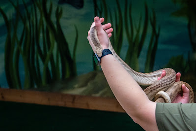 |
| Snake Handler |
 |
| Gator on Display |
After the talk, we headed over to the river boat ride. The white board out front looked like we would have a 50 minute wait until there were spots available on the 1:30 boat but as we approached the volunteer staging the passengers, she told us we could get on the 1 PM so we only had 20 minutes to wait our turn. The pontoon boat looks like it holds 20 passengers plus the captain and the naturalist that does the presentation.
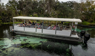 |
| Pontoon Boat at Weeki Wachee |
It isn’t a very long boat ride because the water level is quite low so they can only go so far on the river. The safety talk informed us where the life preservers are but the advice from the guide, if something were to happen and we needed to abandon ship, was to simply stand up - the water was about thigh high.
 |
| On the Boat |
There was limited wildlife spotted along the shore line and in the water, but it was still a pretty ride and fun to be on the water.
 |
| River View |
 |
| Grebe |
 |
| Large Cypress |
Back on shore after the ride, we headed back over to the place where the wildlife talk took place. There are several cages that house the various animals that call this park home.
 |
| Animal Area |
 |
| Tortoise in the Sun |
 |
| Cute Frog |
We make our way over to the mermaid show to see how long the line was for the 3 PM show. From the looks of things, we had plenty of time before we needed to stand in line so we explored the grounds some more. There are several peacocks that wander the grounds. We had seen them in passing earlier but they had found a spot in the shade of a tree to relax.
 |
| So Colorful |
As might be expected, there was a very distinct mermaid theme to nearly everything in the park. Lots of displays to stand next to for pictures. The gift shop was packed full of mermaid merchandise but we didn’t see anything that we felt we just had to have. Buccaneer Bay is a beach area with a couple of water slides and a small wading lagoon. The water slides were not open for the season yet but there was a crew doing some maintenance on one of them. We opted to not get in the water even though there were plenty of people out enjoying the spring water.
 |
| Mermaid Statue |
 |
| Entering Buccaneer Bay |
We head over to line up for the show. A few minutes before the show starts, they let the crowd into the 400 seat theater. The theater is unique since it is built underground with thick glass windows between us on the bleacher seating and the pond formed by the spring. While we wait for the show to start, there is a video program running on several large monitors that describes the history of the show and some of the famous people that have stopped to see the mermaid show. Just before the show starts, one of the performers pops her head out of a hatch above the curtains to get us excited for the show.
 |
| The Crowd Patiently Waits |
 |
| Performer Pops Out |
The show was very entertaining. The windows are fairly large but it isn’t one continuous glass window so there are vertical supports between the windows that obscure the view of all 4 performers but it is possible to see 2 or 3 of them at any given point.
 |
| Floating Mermaid |
 |
| Bubbles |
Each person has an air hose that they use to breathe under water. They control their buoyancy by changing how much air they hold in their lungs. The soundtrack and voices of the show is pre-recorded so the performers are simply lip syncing. It was odd to see the random fish or seaweed float by during the show.
 |
| Taking a Breath |
There are several acts and even costume changes over the course of the 30 minute show. Instead of using the curtains between acts like they might do in a normal stage show, they have air lines in front of all the windows and they make a curtain of bubbles to obscure what is going on “back stage”.
 |
| A Line of Mermaids |
We were glad we made it to see the mermaid show. While it isn’t something I feel we need to see every time we are in the area, it was a fun experience.
The next day we head northeast from camp to another state park but this one is the more typical park with lots of trails. Wekiwa Springs State Park has over 20 miles of trails within its 7000 acres. They do have multi use trails so we considered bringing our bikes but the majority of the geocaches hidden within the park were along hiking trails so we decided to just go for a hike. The Mill Creek Loop Trail is listed in AllTrails as 3.6 miles so we head for that trailhead.
 |
| Entrance at Wekiwa Springs SP |
 |
| Mill Creek Trail |
 |
| Water Crossing |
It is a nice trail but we could tell that the areas just off the trail can get rather wet. One of the caches that is a couple hundred feet off the trail hadn’t been found in several months and several logs for it noted that you might need a kayak to get to ground zero. I found that with careful foot placement I was able to get to the cache without getting wet feet. There were some creative and cute geocaches in the park that made the hike even more interesting.
 |
| New Bridge, Old Bridge |
 |
| Fairy Door at Cache |
 |
| Dragon Cache |
Near the northern end of the loop, the intended route heads west, but we see that there is a trail that continues to the north along the creek. We figured we could stand to get in some extra distance so we continue on. This section of trail was much wetter and quite muddy in spots. It wasn’t so bad that we had to turn back but it did require more careful steps to avoid wet feet. We stopped at a bench along the way that had a nice view of the creek. Several kayakers paddled by.
 |
| Kayakers on the Move |
We discovered Camp Cozy along the way. The trail continues north but we elect to take a service road to avoid the extra mileage and the muddy section. It was somewhat amazing how sandy and dry this section of the hike was compared to the mud just several hundred feet to our east. We did one more side trail trail to go for another cache. In total our hike came in at just over 5.5 miles. This was a nice park and trail. If we had more time in the area it would be a good one to try out the multi use trails with the bikes.
 |
| Camp Cozy |
 |
| Service Road |
We had noticed signs for the actual springs area of the park as we had driven to our hike so we decided to go check that side of the park out. There were many more people here than out on the trails. The spring water emerges here and must be a comfortable temperature because many of the people were in the water. We did a short walk around the springs before heading home.
 |
| Overlooking the Springs |
One of the places we haven’t managed to get back to is the Croom Mountain Bike Trails. It’s kind of surprising since during our past stays in Brooksville, I’ve ridden my mountain bike many dozens of times and even Chris likes biking there. It’s only a 12 mile drive to the main trailhead from camp even though it is only about 4 “crow” miles. We head over with our bikes two days in a row just to enjoy the beautiful trails. I’ve written about this place and the 50 plus miles of trails in past blogs. It’s well worth a visit if you are in the area.
 |
| Spooky Tree at Croom |
On our last full day in the area, we head to one last state park just east of Ocala. Silver Springs State Park sounded kind of unique. Not only does it have lots of hiking trails, a campground and kayak rentals, it also has glass bottom boat rides. When I checked online a couple days in advance to reserve a boat trip, all the spots were taken. So when we arrived and went to show our annual pass to get in to the park, we were surprised when they asked if we wanted to purchase glass bottom boat tickets. Turns out they hold back quite a few tickets for walk ins like us. So don’t get discouraged if you aren’t able to buy tickets online, they may have room for you as well. Tickets for the 2 of us was just over $25. We did have a couple of hours to wait before our ride was to start, but that just meant we could do some of the other things in the park first and have our lunch that we brought along before the ride.
 |
| Fancy Entrance at Silver Springs SP |
The main area of the park includes a restaurant, small museum and just a few trails. We wander around to see the sights and learn that Silver Springs what’s where the 1954 horror film Creature from the Black Lagoon was filmed.
 |
| Glass Bottom Boats |
 |
| Kayakers |
 |
| Fish |
 |
| Snake |
The one main hiking trail on this side of the park looked promising but turned out to be partially closed so we decided to go back to the car, have lunch then drive to the other entrance to the park near the campground where the 10 miles of hiking trails are located.
 |
| Bright Camellia |
 |
| Closed Trail |
Apparently the park has some monkeys living there. The rhesus macaques were released in the park back on the 1930s and there are now approximately 400 in the woods. We didn’t have a lot of time to explore the many miles of trails but had heard the River Trail was a popular place to see the monkeys in person. We did the 1.3 mile trail and saw a kayak launch point but at no time did we see or even hear any monkeys. Maybe that was just as well as it turns out some of these animals are infected with a herpes virus that can be fatal to humans.
 |
| Entrance to River Trail |
 |
| Kayak Launch |
We hustle back to the main park for our scheduled boat ride. Since there are boats leaving every half hour, there were a lot of people in line but the workers do a good job of figuring out everybody’s times and getting us aboard our boat - the Chief Charlie Cypress.
 |
| Glass Bottom Boat Dock |
 |
| Entering Glass Bottom Boat |
Having never been on a glass bottom boat before, I wasn’t sure what to expect. Only the center portion of the boat is glass with benches along either side of the boat. The captain takes us around the main spring area and down the Silver River maybe a third of a mile or so. Along the way he points out where some of the spring outlets are. The water is very clear and there are a lot of fish swimming around.
 |
| Fish in Seaweed |
 |
| Fish Below Us |
There were other sights to see along the shore of the river - birds, turtles and alligators. Switching back and forth between shooting pictures into the dark underwater thru the glass to taking pictures of the animals and other sights to see proved to be challenging. One other issue with our particular boat ride was with one family of four. Actually the parents and one child were well behaved but the 3 year old boy, Case, was crying and screaming for almost the full 30 minutes we were on the boat. Given the enclosed nature of the boats, me and the other 20 people didn’t have the most peaceful boat ride.
 |
| Gator on Shore |
 |
| Sea Hunt Deck |
 |
| Turtle on Log |
There also happens to be a virtual geocache in the park that is only visible via water. We weren’t sure if our boat ride would get us to the proper location. To prove we were at the location, we needed to get a picture of our GPS showing our track put us reasonably close to ground zero or a picture of the statues. Well it turns out that these statues are part of the boat tour so we would have good opportunity to get the proof we needed. The 3 statues are from the 1960’s “I Spy” TV series. That’s not one I remember but might need to check it out as well as the Creature from the Black Lagoon movie. We floated over the statues for some time and I was able to get a picture of my Garmin handheld showing our track, distance to GZ and the statues in the background. I couldn’t have asked for a better shot.
 |
| Statues from "I Spy" |
 |
| Convincing Proof |
After we were back on shore, we considered heading back to do some other hiking trails but ended up driving into Ocala to do one of the Adventure Labs. Tuscawilla Park is on the northeast side of downtown. It includes a pond, ball fields, walking trail and a sculpture park. We enjoyed walking around the park and seeing some of the sculptures.
 |
| Pond at Tuscawilla Park |
 |
| Muscovy Duck |
 |
| Bird Statue |
 |
| Fishing Pole and Bobber Statue |
It is hard to believe that our 6 weeks at Sumter Oaks campground is coming to an end. Having spent so much time in this general area over the past five years, we have come to enjoy the area and the vast amount of outdoor recreational opportunities available. But next we will head back to Titusville and The Great Outdoors to actually stay on our newly purchased property for the first time. From entry logs and our power company’s website, I am able to tell that we have had several tenants camp on our lot over the past month since we closed on our lot for a total of 15 nights but it will be good to try it out ourselves.


