Wednesday, November 8, 2017

Into California for Even More Redwoods

Map of this blog's locations click this link to open the map

As we finish up our stay in Brookings, we have spent 65 nights in Oregon this summer and fall. With the rainy season coming, we need to push south. We have been struggling with how to space and pace our trip south into California. There are a quite a few state and national parks in the northernmost reaches of California that feature coastal redwoods. They seem to be spread out over the first 150 miles of US 101. We have only managed to visit the park just across the Oregon border so that leaves most of area yet to explore.

The original thinking was to stay at the Eureka Elks lodge, but it is pretty far south of some of the spots we want explore and would require several lengthy day trips back and forth to fit them all in. So we do a little more investigation and discover a private campground that is still open in the town of Klamath - a number of campgrounds in these parts close at the end of October. The real selling point for Chinook RV Resort is they are part of the Passport America system. This is a membership program that we subscribe to. Campgrounds that belong to the system offer half price rates. Usually the parks have all sorts of restrictions on when and how many nights campers can take advantage of the 1/2 price. With each campground in control of their regulations, it isn't always easy to find one that works out for us. This one allowed unlimited number of nights at 50% as long as it was between October 1 and mid June.

The drive is only about 50 miles but we will be going through the agricultural checkpoint which hasn't been a problem while in the car but we weren't sure what to expect while driving our home across. Chris had investigated the rules and made sure her grocery shopping in Oregon wouldn't violate the rules. Turns out they didn't really seem too concerned and more or less waved us through. There was some major road construction requiring quite a long wait and then following a pilot car for what seemed like miles. The fog was really rolling in off the ocean and made for a less than stellar travel day. The campground was right along the Klamath River. It appears they have kayak rentals during the summer months. The place is good enough for what we need and is pretty close to many of the things we plan to explore. We sign up for 4 nights at only $20 per night for full hookup.

Klamath River at Chinook RV Resort
We have enough daylight left and it wasn't raining so we headed to Prairie Creek Redwoods State Park just south of Klamath. Ah Pah trail is a short walk in the redwoods. A road previously had been put in through the trees, but they discovered it was causing erosion problems so it was removed back in the 1990's. It was a peaceful walk and we are still amazed just how large these trees are.

We were expecting only a couple days of decent weather before rains so we head one of the highlights of this area - Fern Canyon. It is a fairly remote section on the south side of Prairie Creek Redwoods. The road there first takes us past Elk Meadow - a known hangout for elk. As we made the turn, there weren't any cars parked along the road. A bad sign for us. We stopped and looked in all directions of the meadow but didn't spot any elk there. Half a mile later, where we are supposed to start the 4 mile drive on a winding dirt road back to Fern Canyon, we find a flashing sign indicating the road is closed for construction and won't open again for 2 more days. What a letdown. Not just because we can't see our destination, but it was going to be a full day event so now we need to come up with an impromptu plan B.

The Trillium Falls trail starts at a big parking lot next to the closed road so we decided to at least try out this loop trail at just under 3 miles in length. The falls were not all that impressive but the hike was still worth it. We hoped that the time we spent on the hike would have been long enough to allow the elk to come to their meadow, but as we pulled out, they still were nowhere to be seen. The town of Orick is just a bit south from where we were and the Kuchel Visitor Center is nearby so we head there to get some ideas of what else to do. One suggestion they have is the Tall Trees Grove. It is a 4 mile loop trail that goes past the former tallest tree in the world. To get to the trailhead we needed to register our vehicle and get a permit allowing us to enter a gated road. Most visitors aren't willing or able to commit the time required for this excursion so they tell us they generally don't use up all the permits.


Trillium Falls

Serene Spot to Sit and Relax

Hollowed out Redwood

Quadruplet Redwood Growing into Big Tree
After lunch we head up Bald Hills Road for about 7 miles. It is an extremely curvy and hilly drive mainly heading up. We run into sections of extremely dense fog and are forced to slow down to a crawl. We eventually get to another side road that is gated. Our permit has the daily code required to open the gate. The next 7 miles or so take us generally down to a trailhead parking lot. There are probably half a dozen cars there. We start out on what turned out to be quite a nice hike. Total hike is about four miles but there is a fair amount of elevation variation that makes it somewhat tiring. If you find yourself in the area, plan on three hours to complete the drive and hike. We would recommend this as long as you can spare the time.
Fog Hugging Valley from Overlook

Tunnel Cut Thru Tree

Another Tall Tree

Chris Dwarfed by Tree

Unique Mushrooms
Our drive up Bald Hills Road had taken us right past one of the more famous groves in the area - Lady Bird Johnson Grove. We knew we couldn't complete this so we came back the next morning to give it a look. It was another foggy day so the place wasn't too busy and gave the walk an eerie feel. The loop is only a mile and the trail is in great shape. There are numbered interpretive signs along the trail and even though the sign on the brochure container stated there were no brochures, Chris opened it and found them. It was interesting to hear about the different facts and stories as we did the loop.
Foggy Trail

Spooky Vibes in the Woods

Plaque at Lady Bird Johnson Grove
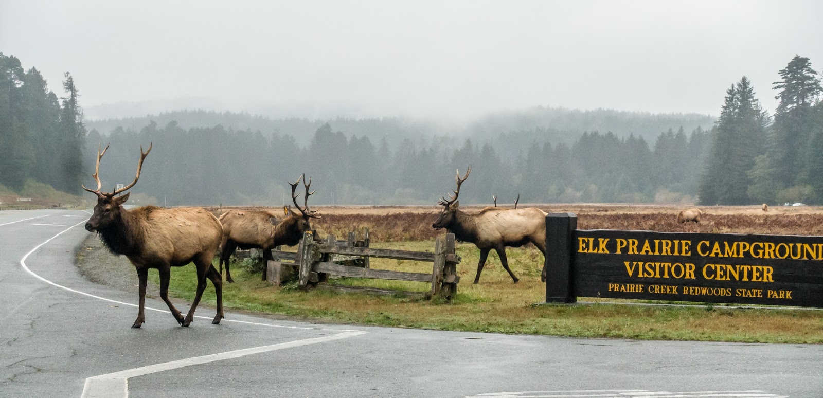
Next we went to Elk Prairie which is just off US 101 along the Newton B. Drury Scenic Parkway. As we were approaching the entrance to the Prairie Creek Visitor Center, there were many cars pulled off on the side of the road. We were optimistic this meant elk were nearby. We pulled over and got out of the car to check it out. There were 12 adult male Roosevelt Elk. Most of them were just laying down but every now and then one would get up and graze. We were a bit surprised to see so many males grouped together. We later found out they had been forced out of the main herd by the alpha male so this was dubbed the bachelor herd. After watching them for a long time, we were getting hungry so we drove into the parking area and had lunch. Near our lunch spot was a good sized white tail buck in the field. Of course after getting up close to the elk, this deer seemed diminutive.
Note Metal Elk in Background with Real Elk

Good Resting Spot


Possible Yawn?

White Tail Deer
A stop at the visitor center, gave us an idea of what hike we could do from there. The Elk Prairie trail is an easy loop that circles the field where the elk currently were hanging out. As we started down the path, we realized the group of elk were up and on the move. I had switched to my smaller camera for the hike but given how close they were, I really didn't need the telephoto lens. One of the males came across the entrance road giving me the eye as it went by. I realized getting out of his way was the wisest move.
Great Campground Advertisement
Two of the others were occasionally doing practice sparring. Butting each other with their antlers. They were even trying to do so while on opposite sides of the split rail fence. As I was trying to get video of them, I had to have Chris watch my back in case the one that had just passed by decided to come back without me noticing. We eventually decided the bulk of the activity was coming to an end so we continued on the hike. By the time we completed the walk and pulled out, most of the elk were gone but several were laying down in the field on the opposite side of the road attracting new visitors. If only these people knew what they had miss just 45 minutes earlier.

The next day was rainy as predicted. Even though the road to Fern Canyon would be open, we decided it wasn't worth trying it in this weather. The forecast for the next day was good, so we just extended our stay here by a day. That is definitely the advantage of not reserving camping spots all the time. It gives us the flexibility to deal with weather or stay longer in areas we decide had more to offer than we anticipated. We did get a little nice weather late in the day and enjoyed a short nearby hike on the Yurok Loop. Plus we stopped at a nearby tourist attraction - Trees of Mystery. We didn't actually partake in the gondola ride and other things requiring an admission fee. But we did check out Paul Bunyan and his faithful ox Babe. They are both quite large. Paul being over 49 feet tall and Babe being 27 feet to the horn tips. Both come in at a whopping 30,000 pounds.

Nice View Along Yurok Loop Trail

Hey Paul, That's Some Babe You Have!
We spend the bulk of the last day exploring Fern Canyon. The road was open and we were sort of able to tell where some of the road construction had taken place. It is about a nine mile drive back to the parking area. The first 6 miles are hilly and winding and dirt, or in many places muddy. Some of the mud is that greasy type that makes one question whether the tires are going to grip as we go down the hill into a turn. We took it slow and had no problems but I could easily see some people doing something stupid. We got there early in the morning and only one other vehicle was parked there before us. We had noticed on the last 3 miles of the drive that follow right along the ocean, there were numerous signs about elk, but not just any elk - Aggressive Elk! We kept an eye out for them but didn't see any. I'm just glad the ones we were within 20 feet of the other day were not aggressive since the sign makes it look like it would hurt.
Don't Turn Your Back on Aggressive Elk
We had thought ahead - it happens sometimes! We brought our knee high waterproof boots. So we switched out of our hiking boots into them. That was one smart decision. The first tenth mile back to the entrance to Fern Canyon was fine, but the water was flowing pretty good in the stream from the recent rains. I won't say it would have been impossible to do the hike and keep feet dry, but it would have been really challenging. At no place was the water more than ankle deep but it was nice to just walk where it made more sense than to attempt to jump from one rock to the next. I suppose our water shoes could have worked but I suspect the water was quite cold. If you come for this hike come prepared.
Fern Covered Walls

A Bend in Fern Canyon
The canyon was quite interesting. The walls are nearly vertical in most spots and there are ferns growing all up and down them. This was a location for one of the scenes from Jurassic Park II. It definitely had that prehistoric feel to it. We did not see any dinosaurs or pterodactyls while we were there. There was one spot where a large fallen tree blocked the canyon pretty well, but we worked our way through it and continued upstream until we spotted a set of stairs on the left leading up and out of the canyon. Once up top, you can either continue inland on other trails or turn back to the ocean and basically follow the canyon but now from above. Another set of stairs led us back to where we started.

Looking Down from Above Fern Canyon
We headed north up the Coastal Trail with the hopes of cutting over to the beach to look for a geocache. But even after going well beyond the cache location, we realized there were no real paths out to the beach. We did try a "short-cut" to the beach when we got to Fern Canyon, but after a bit we found ourselves in standing water nearly overflowing our boots. It turns out there is an easier path to the beach right off the parking lot. Even that wasn't easy since there was a several foot deep water hole requiring a balance beam walk over a large fallen tree. We both made the crossing without any splashes! Half a mile or so down the beach, we finally made it to the geocache we had wanted to find forty minutes earlier.
Balance Beam Tree to Reach Beach
Foamy Waves

Lots of Flowers Along Beach
The plan was to stop to look for elk again but it turned out the scenic road was closed for the day to allow walkers and bikers to have complete access to the road. It didn't appear to be a sanctioned race, just a recreation thing. So instead we drove up US 101 and came over the scenic route to a place just before it was closed off. We parked at the trailhead for Carruthers Cove trail. It is only about 0.8 miles to the beach but it is a good 600 foot descent. We had the trail to ourselves and after getting to the beach we headed a bit north then south just watching the water crash against the rocks along the shoreline. The hike back up was a good workout but it was late afternoon by then so it had cooled off quite a bit so we did okay.
Big Splash


The drive the next day is only about 70 miles to the Eureka Elks Lodge. The sites are nice and have full hookups with 50 amp electric. We also were pleased to find we had reasonable over the air TV coverage here. That permitted me to be lazy and watch some football to relax a bit. The first full day here, we head south about 30 miles or so to the northern entrance to Avenue of the Giants. This is a scenic state route that runs somewhat parallel to US 101 but meanders through some more of the huge redwoods. The general area is Humboldt Redwoods State Park but there didn't seem to be the need to have any type of park pass to explore the areas we stopped at. I was glad to be driving the Jeep and not the motorhome. Some of the massive trees are right next to the road and I suspect it would be pretty easy to clip a mirror. Plus the pullouts are much more manageable in a smaller vehicle.

Shortly after starting on the Avenue of the Giants, a geocache placement got us to stop and explore from one of the pullouts. The geocache was placed near an albino redwood tree. It sounded interesting, but there wasn't a sign at the pullout so most people wouldn't even realize it is there. The main tree itself isn't all that much different than others but all around the base of the tree are root suckers growing a good 15 feet or more and all the needles are white instead of green. It's not clear how photosynthesis works on this part of the tree, but it was pretty interesting to check out.

Albino Redwood

Closeup Albino Needles
A few miles into the drive, we head west on Mattole Road further into the park. Apparently this road eventually finds its way to the Pacific - an area known as the Lost Coast. Supposedly a very scenic drive and quite remote, but it would be its own day trip if we decided to go that route. We only head out as far as Big Trees Day Use Area. By this point, it seems like all these trees are big, so designating a specific area as "Big Trees" seems a bit redundant to us. Chris had scoped out a combination of trails in the area that can be used to create a very nice couple mile hike through some of the redwoods with the turn around point being the presently closed Albee Creek Campground.
Along the Trail
After the hike, we came back to the parking lot of the day use area and realized there was more to check out on the other side of Bull Creek. Unfortunately the park personnel had already removed the bridge so we had to use a few precariously placed logs to get across the creek without getting wet feet. A few of the trees are identified with names and statistics regarding the size of the tree. The names themselves were not all that imaginative. Giant Tree and Tall Tree seemed obvious. Maybe the park should sell the naming rights. That way people could see the Ford F-350 Super Duty Tree!
Giant Tree

Chris Poses with Giant Tree

Tall Tree
After the walks off Mattole Road, we head back to Avenue of the Giants and stop at the nearby Founders Grove. There is a short nature walk through the grove with interpretive stops at some of the more fascinating sights. The Founder's Tree is impressive standing 346 feet tall. But even more impressive is the Dyerville Giant - a 362 foot redwood that fell in 1991. The path now takes people right alongside the 17 foot diameter tree that still dwarfs people that walk by it.
Founders Tree

Roots of Dyerville Giant

Suspect This Tree Made a Noise When it Fell
The Burlington Park Headquarters are just a few miles further south. They have a very nicely done visitor center that is definitely worth a half hour browse. Inside is a "travel log". It was created by naturalist Charles Kellogg from a single 8 ton redwood log that he turned into a motorhome of sorts by hollowing it out and building it onto a 1917 Nash-Quad truck. Not as nice as our rig, but definitely more unique. He toured the country for several years after completing it.
Travel Log

Living Quarters of Travel Log
Nice Wood for Some Project
This stop got us roughly halfway along the Avenue of the Giants, but the rest of the drive would need to wait for another day and another trip to the area. As we head back north, we squeeze in a 2.5 mile trail we had skipped earlier in the day. The Drury-Chaney Loop trail is a pleasant and nearly flat walk through some more redwoods. It was late in the afternoon, so there was definitely a chill in the air. It seems a bit odd, but it almost feels like we have become saturated with redwoods in the past 10 days or so. They are still impressive to see and I could see us coming back sometime in the future to explore some of the parts of the redwoods we missed, but maybe we need a break from them in order to fully appreciate them.

We have two more days to spend in Eureka but one of them is forecast to be very rainy and windy so we pick a good hike for our nice day. Arcata Community Forest is just a few miles north of Eureka and has quite an extensive trail system. Some of the trails are open to biking or horseback riding which from our experience often produces some fairly challenging surface conditions. But we were pleasantly surprised with how nice the trails were. We saw both cyclists and horses while we were hiking so we know it does get used. We used the dozen or so caches help direct our adventures but we discovered it is quite a hilly park and many of the caches were either missing or hidden quite well. So our caching experience was not the greatest but it was still a nice park to hike. We ended up doing just a small portion of the trails.

As forecast, our last day there was a wet and windy one. I managed to get out for a geocache early in the day just before the front moved in. The rest of the day was spent hunkered down in the rig staying warm and dry. Then we headed out to a local microbrewery for Chris' birthday dinner. We will be heading south into California wine country which is also the area that had very recently been devastated by wild fires.

Monday, October 30, 2017

Our Last Weeks in Oregon - Cape Blanco and Brookings

Map of this blog's locations click this link to open the map

We wrap up our stay along the Oregon coast with a couple more stops. The first being Cape Blanco State Park. We have heard many good things about this place so we figured we owed it to ourselves to check it out first hand. The park is set back off of US 101 about five miles or so on a cape that juts out into the Pacific. The campground is just before the beautiful lighthouse that is built at the edge of the bluff. Several websites and  tourist guides state this is the most westerly point in the lower 48. It is one thing for a restaurant to claim it has the best burger or a pizzeria stating their pizza is ranked number one - that's called marketing. But we have been to Cape Flattery in Washington state which also makes this claim. Which one is right? Well it's not even a close call that may be subject to interpretation. Using Google Earth as my source, I find Cape Flattery to be roughly 10 miles further west than Cape Blanco. Had it been a few hundred feet, I might be willing to call it a draw. I guess the local tourist industry can be credited with good marketing because while we were here, we overheard somebody on a phone call saying how they went to the most western point in the lower 48 at Cape Blanco. I resisted the urge to interrupt and correct her!

The campground here does not take reservations. We had no problems getting a site coming in midweek during off season. It was a bit more crowded than we may have expected but we found a nice private site and got setup. The weather forecast was not looking too promising so we paid for 4 nights. There was no television reception here but with the cellular booster, we had reasonable signal. There is water and 50 amp electric at each site but no sewer hookup. In fact the dump station on the way in is closed but your receipt will permit you to dump at another Oregon state park. There are a couple campground host sites and four lighthouse volunteer sites which fortunately have full hookups. I doubt they would get any volunteers otherwise.

Rough Seas at Cape Blanco
We had passed through the town of Bandon just north of here. Supposedly it has a cute downtown area that is nice to stroll around. We head there on our first full day, but we discovered the weather forecast was right, it was raining pretty good. Even with rain coats and hats, we found it wasn't a lot of fun to window shop so we found a library to refresh our video selections and then stopped for groceries.

The following day was much better so we headed out to the lighthouse while we could. The winds were whipping up the waves but the lighthouse is up a couple hundred feet on a bluff so you get a commanding view of the ocean with no chance of a "sneaker" wave catching you off guard.  The lighthouse is still in operation and the volunteers give tours up in the tower for a whopping $2 per person. Being this late in the season, the couple that provided our tour had their stories well memorized. They provide lots of insight to the history of it as well as the various lighthouse keepers that used to live out here in this desolate spot. With automation, the concept of a keeper is just a distant memory. We got to talking with the couple about their RV travels. At the end of October, this assignment ends and they head just a little bit south for another 1 month "job". I suppose if we ever wanted to do some volunteer assignment, this might be a neat one to try.

Sign with Lighthouse in Background
Cape Blanco Lighthouse
Lamp Through Fresnel Lens
On a geocaching tangent, back in August, Geocaching Headquarters announced something called "virtual rewards". It is a program to allow a limited number of virtual caches to be created. For the non-geocacher, a virtual cache is one that has no physical container with a log for someone to find and sign. Instead the cache owner asks the finder to email them with the answer to some sort of question that can be found at the location and hopefully cannot simply be "googled" to prevent armchair finds. In the early days of geocaching, a virtual cache was a way to have a cache at a location where a physical cache was inappropriate or not permitted. Apparently hiders were coming up with all sorts of lame virtual caches so they were no longer permitted to be placed back in 2005 - well before we even started to cache. Existing virtual caches were grandfathered but no new ones have been created in over a decade.

Geocaching HQ came up with an algorithm to rate cache owners. It is unclear what the criteria was for this rating but likely had something to do with owners placing creative caches and maintaining them. They favored quality over quantity of hides. Then the top 1% of the cache owners were selected and awarded the privilege of placing a virtual cache. When we first heard of the program, we thought it sounded like a great thing and how it would be fun to be able to place a virtual cache. We never imaged we would be selected, but when we checked email the following day, we found a virtual reward had been bestowed on us! When I checked with several geocachers back in Rochester, it seems there were several others that were given one as well - a good showing for western New York.

We realized that we likely wouldn't make it back to the Rochester area in time to place our virtual in that area given there is a one year limit on placing it. So since August, we have been keeping our eyes open for an ideal location to bring people. As we walked around the grounds of this lighthouse and saw the incredible views offered from here, we realized this might be the location. But we needed to come up with a something the cacher determine while on site that couldn't be determined remotely. The volunteers had pointed out an interesting feature inside the lighthouse building that most people wouldn't even notice. Maybe we could use that? Well it turns out the lighthouse itself is only open April thru October and even then only certain days and hours. So having the verification step require entry to the building would be too limiting. One is permitted to walk the lighthouse grounds during daylight hours so we looked over the outside of the lighthouse for some sort of feature that we might be able to use. We even asked the volunteers to see if they were aware of anything. Eventually we came up with something a cacher could count on site that we suspect wouldn't be discovered online.

I contacted the local geocache reviewer to verify there were no issues with placing a virtual cache here at the lighthouse. After receiving an optimistic response, we decided to go ahead and create the cache page hoping to get it published before we left the area.  After one small correction, we managed to get required approval. Here is the link to the cache. Cape Blanco Lighthouse Virtual Cache If you are a cacher and make it to the area, stop by Cape Blanco Lighthouse.

Another place we checked out was the Port Orford Lifeboat Station Museum. There is a retired lifeboat on the grounds and one of the buildings houses the museum. We were greeted by the volunteers that are also RVers working there.. We took a short tour of the museum and then ended up chatting with the volunteers until it was closing time. With some daylight left and decent weather, we headed out to do a short loop trail behind the  museum. There are a couple caches and it was also a very scenic view.

Lifeboat

Inside Museum

Nellies Cove Near Lifeboat Museum
We experienced two days of bad weather. One day included heavy rains and gale force winds. We had kept our foul weather gear when we moved into the motorhome but other than using the raincoats from time to time, we hadn't needed the rain pants or knee high boots yet. Well this was the time to locate them and try them out. There were a few geocaches in the park within a quarter mile of the campsite. We were able to follow a trail in the woods for much of the walk so it wasn't very windy, just wet. But the hiding spot was on a bluff, out in the open, overlooking the Pacific. It was next to impossible to even walk out to the hiding spot let alone look for the cache. We lasted about a minute but had no luck so we moved onto a different cache. This one also turned out to be in a very exposed location but we managed to find the container, then took it back into the tree cover to open and sign the log. I guess this makes us serious geocachers? I suspect Chris would use another term.

We decided to stay a few more days since the weather looked to get better and there were things we wanted to see and do in the area we hadn't gotten to yet. On the morning after the rains, we headed south to try the hike up Humbug Mountain in a state park named after the mountain. It is a 5.3 mile hike with nearly 2400 feet of elevation gained. After the first mile of climbing, you hit the loop portion of the trail and have the option of the east or west side of the loop. We knew we would do the loop so it was just a matter of which direction would be the uphill portion. We picked the west side because it was a little bit shorter which would make it the steeper path. We have found it is easier for us to go up steep and possibly wet trails than come down them. It worked out well and other than the hike being a good workout, it was a pleasant walk. Along the way there are glimpses of the ocean thru the trees. There is a short spur trail that leads to the peak and since we had come this far, we knew we had to finish it. There is a bench but the view isn't the greatest since there are quite a few trees in the way. Heading down the east portion of the loop was a piece of cake. The whole trail was in remarkably good shape given all the rain over the last couple days.

View Along Humbug Mountain Trail
On the last full day here, we had some more good weather so we picked out another hike just a bit north of our camp. Blacklock Point trail starts at the Cape Blanco Airport and follows the fence line for a bit before becoming more scenic. It is a 4+ mile hike but is relatively flat with only a few hundred feet of elevation change. With all the rains, we did run into some large puddles, but they must be here often enough because they all seemed to have side paths in the woods around them. It is easy to tell when we are nearing the coast. The roar from the constant crashing of waves carries quite a distance into the woods. There are a couple different great viewing spots at the point. I even managed to get Chris to head partway out one narrow path the goes pretty much out to the tip of the headland.
Blacklock Point

Sitting on Blacklock Point

Mushroom Along Trail

From here, we head north up the trail towards Floras Lake. We get in another half mile or so to search for a supposed former post office. Our Garmin had the point of interest listed but after wandering off trail for a bit, we saw no indication of a former structure or foundation. We later discovered that the town of Lakeport had been a real place in the early 1900's but was short lived and by 1915 it had closed down the post office. I guess a century of weather right on the Pacific coast took its toll on the old buildings. The complete hike was an easy one and worth it to get the isolated views from the Blacklock Point.

Windswept Tree on Coast

Foamy Surf
We still had one more place to visit before we head out. The Hughes house is just down the road from the lighthouse. It was built by one of the early lighthouse keepers back in the late 1890's. Volunteers give tours of the beautiful house and tell all sorts of stories about the people that lived here in the early years. 
Hughes House at Cape Blanco

Nice Guest Bedroom

Old Washing Machine
Our week in Cape Blanco seemed to go fast and even though we had room in our holding tanks, we decided to not extend a couple more days but head south to our last stop in Oregon - Brookings. The plan is to stay at the Elks Lodge. There were only a few other rigs here and we managed to get one of the two pull thru sites. They have 50 amp electric and water and a dump station. They even had wifi that was halfway decent. It is a nice lodge with a good view overlooking town and the ocean. We decided to treat ourselves to the fish and chips dinner they were having that first night. After dinner, we had a couple beers and sat and talked with a local member trying to get some ideas of any special local things we had to see. We also learned that this was right next to a fire we had been hearing about most of the summer. The Chetco-Bar fire ended up consuming over 190,000 acres mainly to the east of town although several of the lodge members did lose their homes from this fire. I'm just glad we didn't try to visit here a couple months ago.

The drive down US 101 had taken us past many different pullouts. Some are just there to let people stop for the view. Others are parking areas for various trails along the way. We headed north from town on the first day to explore some of the things we had heard were worth it. Our first stop was part of Samuel Boardman State Scenic Corridor - Whaleshead Picnic Area. It was fun to explore along the rocks and sandy beach as the waves were coming in. Then we headed up a pretty steep trail to get to a nice viewpoint overlooking this area of the coast.


Another stop was Arch Rock viewpoint. As we have come to expect, there are numerous sea stacks along the Oregon coast but this one is unique in that it has a huge arch eroded into it. In another thousand years or so, it might end up being just two singular sea stacks, but right now the arch is pretty impressive. Plus there are some great views of the coast from this stop.

View from Arch Rock Viewpoint

Another Nice View
We also stop to hike down a portion of the Oregon Coast Trail to Secret Beach. We started at the Thunder Rock Cove viewpoint which wasn't all that great probably due to the late afternoon sun glare. The hike down to the beach isn't all that long, probably less than a mile, but the last portion is steep. Like many of the coastal features, tide conditions are critical. Sometimes high tides are better for things, but in this case, Secret Beach can only be explored at low tide. We got there as the tide was coming in. I managed to get down to the sand and checked out the nearby waterfall but wasn't able to do much more. It was a nice hike and recommend you check it out if you're in the area.
North End of Secret Beach

South End of Secret Beach

Tide Coming In
There were lots of hiking trails we likely would have tried out in the national forest land east of town, but this area is closed right now from the Chetco Bar fire. I suspect that many of the geocaches that were hidden up there have been destroyed as well. We did find that Alfred Loeb State Park was not impacted by the fire and is just west of the closed areas. We head there to do some hiking. The trail we pick follows along the western bank of the Chetco River. It was a nice trail with only a couple other people out using it while we were there. Heading north, in less than a mile we exit the state park and enter national forest land. It is there we try out the Redwood Nature Trail. The loop is just over a mile long with a few hundred feet of elevation change. It was our first hike in redwoods in decades. We have seen our fair share of huge trees in Washington and Oregon this past summer but these proved to be even more impressive - at least from a height standpoint. We try to continue up the road further into the national forest but alas the road is closed in less than a mile.
Along Bank of Chetco River at Loeb State Park


Chris Poses with Redwood

Bridge Over Creek on Nature Trail
We head back into Brookings and go to Harris Beach State Park. We start out by taking the trail up to Harris Butte. It is a short but steep trail to a fenced in overlook. Given the drop off, I suppose the fence is a good idea. The views were quite nice although there is a marine fog way out over the ocean.
View from Harris Butte

View of Harris Butte
Next we head back down to the beach and sit to enjoy the sights and sounds of the waves crashing. As we started to walk to a different section of the beach, the fog layer rolled in and even the largest sea stack just off the shore completely disappeared from view. With the low visibility came some pretty chilly temperatures as well. We decided to just pack it in and head back to camp.
Pacific Coast at Harris Beach State Park
The next day was still a bit foggy but wasn't raining so we packed up the car and headed south to Crescent City California. It is only about 30 miles south of Brookings. The thing we hadn't realized is California has agriculture checkpoints on the way into the state. It was a pretty quick stop only being asked if we had any citrus. They didn't care about our bananas. We stop at the visitor center for the Redwood National and State Parks in downtown. The woman at the desk was extremely helpful. Once we told her we had several weeks to spend in the region, she was able to give us the full description of what we should visit. I suspect most people stopping by, tell her they have a few hours or a day to spend. With several marked up maps and brochures, we decide to check out the lighthouse in town before heading to see the redwoods.

Battery Point lighthouse is just a short drive from where we are. As we come down the trail from the parking lot, we realize that visiting this place requires timing the tide. The tide is going out but we still have a couple hours before it is low tide. As we watch the waves come and go, there appear to be brief moments when you would get wet shoes, but other times when it would be downright dangerous to try to cross. The waves come from both the left and right sides of the path. At one point, a big wave snuck in and the handful of us assessing the situation were forced to run back. I guess the signs we have seen from time to time along the coast about "sneaker" waves and not turning your back on the ocean are good advice. We decide to skip the lighthouse with the hopes of making it back at some better time but that never happens.

Google Earth View of Battery Point Lighthouse at High Tide

From a Distance

Another Battery Point Lighthouse View
One of the recommended drives was to head into Jedediah Smith Redwoods State Park on Howland Hill Road. The road starts out paved and not particularly scenic, but as we start to drive up and up on all the switchbacks, the road gets narrow and becomes gravel. There are only a few stretches that seem a bit like driving on moguls. The real change is when you realize you are winding your way through hundreds of some of the largest trees we have ever experienced. At times the road is definitely one lane especially when you are forced to skirt by one of the behemoths. For the most part the traffic wasn't bad and since everyone is driving slowly we didn't run into problems. There are several pullouts that are apparently used to access several of the trails that wind through the woods.
Along Howland Hill Road

Large Redwood in Foreground
Today we stop at Stout Grove. This is more than just a small pullout. There is a parking lot, restroom and even a geocache nearby. The place was quite popular and we got one of the last legal parking spots. The trail is only six tenths of a mile and is reasonably flat. The trees in this grove are astounding. I swear all the visitors are walking with their heads tilted back and looking up. A stark contrast to what has become normal - people walking while looking down at cell phones. The trees are huge at the base and I found it difficult to get pictures that exhibit this fact. And as I write this, there aren't even words to describe them. They must be visited in person to truly experience them. Probably even more impressive are how tall the trees are. Many are approaching 300 feet. No matter how far you tilt your head back, you really can't even begin to see the tops.
Large Burnt Stump at Stout Grove

Chris Poses with Large Roots of Redwood
From here we continue driving north east on Howland Hill Road and eventually run into US 199. We stop at another visitor center and stamp our national park passport since this area is a joint state and national park. From here we continue west with a stop to do a couple other loop trails thru the redwoods. The Hatton Loop trail is about half a mile long and we had this trail to ourselves. Across the highway is the Simpson-Reed and Peterson Memorial loops. Combined these are roughly a mile loop. What we find interesting is that many of the toppled over giants are just as fascinating as the living ones. They provide a glimpse at the root structure or a possible burl that had formed a hundred feet up the tree but is now at eye level.
Fallen Redwood Still Towers Over Our Heads
We have started to get accustomed to the foggy, cloudy, misty weather along the Oregon coast. At this time of year, it's just a fact of life. At least it isn't the nearly constant rain they get in the winter months. We head out for another hike on a blustery day hoping to not get too wet. The "333" trail, so named because the trailhead is near the 333 mile marker along US 101, would probably not have been a hike we would have even discovered. The dozen geocaches along the trail made us realize there is a trail here and they even provided us a way to confirm we were following the correct trail. For part of the hike, we follow the Oregon Coast trail. Other parts are specifically identified as the 333 trail while a good portion of the hike is along the beach. The initial portion of the hike was on a slightly overgrown trail but it wasn't bad. There were lots of twists and turns as we worked our way down to the beach.
Heading Down 333 Trail to Beach
From here we headed north stopping to look for the half dozen caches along the way. We even stopped at a big piece of driftwood to have our lunch before continuing on. The waves seemed especially strong today but we were here near low tide so we had plenty of beach to walk on. The only potential trouble spot was where to turn inland from the beach. There were no noticeable signs or cairns to mark the way. We only knew to turn because of a geocache had been placed nearby to be used as a waypoint to signify where to turn. After a couple of DNFs (did not finds), we slowly made our way up the steep and sometimes slippery trail. By the time we made it back to the car, we had logged over five miles. Not our longest hike but a nice one nonetheless.
Large Waves at Lunch Stop
Interesting Plant
On our last full day before moving on south, we headed right back to Jedediah Smith with the intention of trying one of the more popular hiking trails we had driven past a couple days earlier. The Boy Scout Tree Trail is an out and back trail that covers about 5.4 miles round trip. The trail ends at Fern Falls. From the descriptions we had read, the trail sounded like a winner, and it was. I might say the only problem is that much of the trail has lots of roots. Not just big ones but areas with a tangle of medium sized ones running every which way. With all the tall redwoods, we often would be walking with our heads tilted back and up. The footing was tricky at times and not paying attention to the trail could lead to some slips and falls if not careful. We needed to learn to stop if we wanted to admire the trees.
Chris the Tree Hugger
We only ran into a couple groups of other hikers heading out as we head in. As we approach the end of the trail, we spot the obvious sign to a steep spur trail to the right. The sign reads "B.S. Tree". It is less than a 100 foot detour but well worth it. It takes you to the Boy Scout tree. This is a massive tree - over 23 feet in diameter and over 240 feet tall. It is a "double-stem" coast Redwood. At the base, it isn't obvious there are two trees since they have fused together at ground level. It's not until you look up about 75 feet or so that you see the two trunks continuing on to their own crowns. There is a wooden sign high up on the tree so you don't miss it. Apparently there isn't consensus on how the tree got named the Boy Scout tree but regardless, it is one (or two) impressive tree(s).
Sign on Boy Scott Tree

Chris Gives the Boy Scout Salute
We continue the rest of the way to Fern Falls. Had this been the only interesting thing to see along the hike, we might call it a disappointment. The falls are far from impressive. Even if the water flow had been greater, I'm not sure it would have been worth it. But this hike isn't about the falls, it's about the walk surrounded by all the giant redwoods. We enjoyed our lunch at the falls and then started back. Apparently we beat the rush because we passed by about 15 people heading back to the falls. We had spent a half hour there with nothing but an occasional bird or the sound of a falling maple leaf to distract us. I can see why this hike is a favorite hike in the area.
Lackluster Fern Falls

The Look Down at Fern Falls