Map of this blog's locations click this link to open the map
Our fun on Jekyll Island came to a close and it was time to move on. We weren’t going very far, just over 50 miles to Crooked River State Park in Saint Marys Georgia. It’s just a few miles from the Florida state line. The campground has about 60 sites and the majority of them are quite large. Some of the sites have full hookups and there are many pull thru sites. Our spot was a back in site with water and 50 amp electric. Since we are only here for 8 nights, not having sewer hookup won’t be a problem. It did seem odd to see some of the small pop up trailers in a 90 foot pull thru site but our spot was more than big enough for us. We got a short walk in after getting situated. There are lots of trails that meander through the park.
The next day we loaded the bikes on the rack and drove into downtown St Marys. The plan was to bike around the area to get a feel for the town. Before starting on the ride, we walked over to a geocache near a cemetery just a few blocks away. On our way back to our car, another car pulled up next to us. The driver asked us where we are from. He could tell we weren’t from here since our walking pace was faster than the typical local. Turned out the guy is the mayor of St Marys and he welcomed us to town and hoped we enjoy our stay. I guess we found ourselves in a friendly small town. We hopped on the bikes and did a random bike ride around town checking out a few sights and finding several geocaches.
 |
| Along St Marys River |
 |
| Waterfront Stage in Park |
We headed south to Florida the following day. Fort Clinch State Park is just across the river from St Marys. We decided it makes sense to by an annual Florida State Park Pass since we will be in the state for more than 4 months. This park has a fair amount to check out. We start the morning by riding the 6 mile mountain bike trail loop. Being Florida, there aren’t any really serious hills. But there are some sections with lots of tree roots making for a challenging ride at times. It is all single track and fortunately the trail is configured to be one way so we don’t have to worry about oncoming traffic. The trail basically parallels the park road on either side of the road. When we got to the halfway point closer to the park entrance station, Chris decided she had had enough of the loose sand and roots and would just ride the park road back to the main parking lot. I continued up the trail and made pretty good time since I didn’t have to worry about how Chris was doing. I did nearly do a face plant at one point when I discovered a hidden root under the loose sand that steered my front wheel right into a bush.
When I got back, we had lunch and changed out of our cycling gear to do a hike or two. We headed out a trail that takes us to the beach along the St Marys River on the outside of the old fort. We noticed something in the water quite a distance away but initially couldn’t identify it. Could tell it was big and thought it might have been a dock but then we realized it was moving, and heading our direction. Turns out it was a submarine. Our campground is right next to the Naval Submarine Base Kings Bay - part of the US Navy. I guess this sub was heading home. It was impressively big and given most of the thing is underwater, we can hardly imagine its actual size.
 |
| Submarine Passes By |
 |
| Beach at Fort Clinch State Park |
After the sub passed by and we concluded the walk around the outside of the fort. We decided it was worth the extra $2.50 per person to actually tour the inside of Fort Clinch. We have visited quite a few historic forts during our travels. Fort Stevens on the northern Oregon coast and Fort Worden on the Olympic Peninsula in Washington State are two memorable ones from 2017 and more recently, Fort Knox in Prospect Maine. This one is is definitely worth the admission cost but it isn’t quite as large or elaborate as these other forts. They do still have a handful of the old cannons positioned around the perimeter. The stone and brick work is definitely impressive. There are curved stairs leading to the upper level at each of the five corners. They are roughly S-shaped which must have made for very difficult construction, but they have held up quite well given the Fort was built in the mid 1800’s. Many of the rooms are open and furnished as they might have been back in the day. From the descriptions, the jail was mostly used as a sobering up spot for the soldiers after a bit too much drinking.
 |
| River Side of Fort Clinch |
 |
| Entrance to Fort Clinch |
 |
| Tunnel into Courtyard |
 |
| Curved Staircase |
 |
| Overlooking Interior of Fort |
 |
| Ready, Aim, Fire |
 |
| Fort's Wall |
 |
| Ferns Taking Hold |
 |
| Soldier's Clothing |
 |
| S Curved Staircase |
 |
| Laundry Room |
 |
| Interior of Jail Cell |
The following day we did a more leisurely bike ride along the trails to the east of the park. Before getting to the Sempervirens Trail, we pass 11 cabins that are much bigger than those you find at most campgrounds. They can sleep 8 to 10 people and look like they would be ideal for a family getaway. We discovered that there are many more trails than the park map highlights. We try a few side trails but seem to always run into loose sand or downed trees forcing us to retreat. We eventually made it out most of the way to the Bay Boardwalk Trail but needed to bypass the actual boardwalk since it is in disrepair.
 |
| Overlooking Crooked River |
 |
| Boardwalk Needing TLC |
We headed back into St Marys the next day to check out the Submarine Museum. Before getting into town, we stop at the main entrance to the Submarine Base. There is a small parking lot prior to entering the military check point. The only thing for us civilians to see there is the retired USS George Bancroft. This sub was first launched in 1965 and retired in 1993. The tower (or fin) from the sub is now mounted in the ground to appear as if the submarine is submerged in terra firma. It was pretty neat to see. There happens to be a fairly new geocache hidden nearby this sub, but from the descriptions of other geocachers, the MPs at the nearby entrance gate aren’t too keen about strangers wandering around and looking suspicious. One cacher was detained for 45 minutes while being questioned about what she was doing. We opted to not push our luck. We don’t have to go for every geocache.
 |
| USS George Bancroft |
The museum is right on the main street in St Marys. While it is a rather small place, it was packed full of all sorts of displays and memorabilia from everything submarine related. Surprisingly we spent nearly 2 hours looking it all over and watching a video on how submarines work and what it’s like to be a submariner. Possibly the neatest thing there is the actual periscope from a retired sub. It can be turned and focused on boats in the nearby river. I even managed to get a reasonably good picture through the eyepiece. Some people may find the museum boring or ho-hum, but we made the most of it.
 |
| Display at Submarine Museum |
 |
| Interesting Drawing |
 |
| Suit Up |
 |
| Model of USS Grayback |
 |
| Unique Propulsion Method |
 |
| Submarine Controls |
 |
| Up Periscope |
 |
| Picture Through Periscope |
The next couple of days were slow from a tourist standpoint. On Thanksgiving Day, we didn’t do a whole lot but Chris did make a very nice dinner. A new cheesecake recipe has made it to the top of our desert list - pumpkin cheesecake is better than pumpkin pie! Black Friday was quite rainy so again we didn’t get out for much more than a short walk in the campground.
On our last full day in the area, the weather was dry so we drove a bit north of camp to the Georgia Coast Rail-Trail near White Oak Georgia. It turned out to be quite a nice walk. Much wider than most trails like this and about 8 geocaches along the couple mile section of the trail we walked. After this, we checked out the old tabby sugar works building right across from the submarine base. We have now seen tabby buildings in a couple locations but this place is much bigger than the house on Jekyll Island. That’s because this used to be a sugar processing plant back in the early 1800’s. It’s in reasonable shape for a building that is nearly 200 years old.
 |
| Nice Wide Rail Trail |
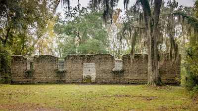 |
| Old Sugar Processing Building |
 |
| Worn Interior Wall |
 |
| Close-up of Tabby Wall |
Crooked River was a nice stop, but admittedly there weren’t that many things to see in the area. We might have been better off using some of the 8 nights we spent there and pushed them back to extend our stay on Jekyll Island or move them forward to our next stop at O’Leno State Park in High Springs Florida. But part of the fun with our lifestyle is learning these things for the future.


