Sunday, November 1, 2020

Off to the Emerald Coast of Florida

  Map of this blog's locations click this link to open the map

It was a quick 2 night stay in Hattiesburg Mississippi and while I suspect there were lots of other things to see and do in the area, we needed to move on. Our next stop was a 10 night stay at Fred Gannon Rocky Bayou State Park in the town of Niceville Florida. It’s about 8 miles from the Emerald Coast of Florida near Destin. It isn’t on the Gulf Coast but it’s close and is on water from the Gulf. Even though we booked the site over two months ago, we weren’t able to get one site for the full duration of our stay. So we will be in one site for 6 nights and another for 4. There are a couple other state parks right on the coast, but availability there was even tougher so Gannon it was. Our general experience with Florida State Parks it wonderful but crowded so planning ahead for anything more than a night or two is required. The drive from Hattiesburg is about 220 miles and a fairly easy trip.

The park isn’t very large with only about 40 sites around a half mile loop but the sites are rather spacious and fairly wooded. Our first site is nice with a view of Rocky Bayou less than 200 feet from our front window. It’s a fairly large body of water with the opposite shore a half mile away.

Rocky Bayou

Our First Site at Gannon

When we making our travel plans, we were drawn to this area because there seemed to be a large number of hiking and biking trails and plenty of geocaches as well. Plus we were close enough to the beach if we wanted a lazy day of sitting on the sand with the Gulf of Mexico at our feet. Once we got here and started to make plans as to what we would do first, we quickly discovered that we were smack dab in the middle of Eglin Air Force Base. Not so much that there are barracks and airstrips right next door, but the base comprises 460,000 acres of land. It’s a hard number to wrap your head around - think about 55 miles wide and 12 miles tall.

Most of this land is forest area and that is where many of the hiking and biking areas we were hoping to visit are located. To legally access the recreation areas of the base, one must purchase a permit. While not prohibitively expensive at $20 per person for an annual pass, we probably would have purchased passes but for one big problem. The base is divided up into dozens of different regions or sectors and before heading out to a region, one must check a website that would list what areas were open for recreation and which ones were closed for that day. We tried to check the site multiple times to see how it worked but each time the message said to check back later. Given we would often hear bombing runs nearby to the campground we realized going out there without the right information could be dangerous. Of course that meant the bulk of our intended plans would need to change.

The state park does have several hiking trails and a large day use area. We take advantage of what is within walking distance of the rig. One of the first things we discover is how acclimated we had become to the dry weather in Arizona. After spending 9 plus months in the dry desert southwest, having Florida style humidity is challenging to adapt to. There are three trails within the park: 1.0, 0.75 and 0.5 mile loops. They are all nice walks and not very strenuous given the flatness in this part of Florida. The shortest trail does pass by the Bayou and we can see all sorts of birds feeding and people out enjoying the water. We also rediscovered some of the huge spiders that call Florida home. The golden silk orb weaver is menacing looking. With a body the size of my thumb and large webs, we need to keep an eye open for these especially when venturing off trail in search of a geocache. Along one trail is a 500 pound concrete bomb used during training exercises from Eglin Air Base during World War II.

Kayakers on Bayou

Eeeek!!!

Practice Bomb

The day use area includes several picnic shelters and benches along the shoreline. There is also a boat ramp and based on the parking area being nearly full with trucks and empty boat trailers, I suspect this is a popular spot to come launch your boat or jet ski.

Beautiful Water View


Gannon Boat Ramp

We did a day trip east of Niceville to try out a bike ride. The Longleaf Pine Greenway Trail is just over 7 miles one way and the plan was to take that out to County Road 395 just outside Seagrove Beach and find a bite to eat then either come back the same trail, or head towards the beach and follow the paved bike path that seemed to follow next to Highway 30A that runs along all the small beach towns. The trail started out quite nice. There were a few others out for a walk but it wasn’t too crowded. It is generally a singletrack that winds thru the pines with lots of palmettos in the understory. There are some sandy sections but for the most part the trail was firm enough to bike through. There was one section under water but from the looks of things this is a frequent occurrence and a side trail has developed to get around it.

Longleaf Pine Trail Markers

Singletrack Thru Pines

Submerged Trail


After 5 miles, we crossed County Road 283 intending to continue on the trail for another 2 miles. Unfortunately there was caution tape and a sign at the trailhead stating it was closed east of here. We momentarily considered crossing the tape and seeing whether it was closed due to flooding or some storm damage but we decided to head south to 30A and follow the bike path along the road. We passed by a large parking area and headed back to look for a geocache hidden nearby. We discovered a very long boardwalk that winded thru the canopy of trees with lots of standing water below. It was a very secluded spot and made for a good place for a snack before continuing back to the road. This bike path along 30A turned out to be a very popular route and made for a challenging ride to avoid pedestrians and other bicyclists. We didn’t find a food joint that piqued our interest so we headed to a grocery store up from the beach for subs. It wasn’t the most scenic spot but met our goal and kept us out of the large crowds.

Dead End Boardwalk

For the return trip, we saw there was a way to avoid some of the large crowds in Seagrove Beach by taking residential roads thru a community called WaterColor. Slowly pedaling thru the side roads, it wasn’t exactly clear what this place was. There were plenty of small homes lining the streets spaced close enough to be able to pass the salt and pepper to your neighbors during dinner. There also seemed to be some sort of inn and communal areas. Not exactly our style of living but quaint nonetheless. Once back on the bike path, we continue west with a short detour to Grayton Beach. The last tenth of a mile was so sandy we needed to simply push the bikes to get to the shoreline. From the looks of things, this area of beach is accessible to motor vehicles and lots of people were out enjoying the water. We eventually made it back to the parking lot and our Jeep. Not exactly our planned route but it was a nice 19 mile bike ride.

Grayton Beach

19 Mile Bike Track

The next day we head back in the same general direction but about 15 miles further east to the Panama City Beach Conservation Park. What attracted us to this place were over 40 geocaches hidden along the dozens of miles of trails in the 2900 acre park. We figured we could handle another biking day and cover most of the park in one day via bike rather than hiking on multiple days. From the looks of things, it is a reasonably new park. A former pine plantation has been turned into the final stage of the town’s wastewater treatment process. The trails are actually wide hard-packed roads so there aren’t issues with running into deep sand sections.

Trail at Conservation Park

Upon finding one of the first geocaches along our route, I noticed a recent finder was a fellow geocacher from our old home in western New York. We are continually amazed to find logs from people we know in far off and sometimes remote locations. Turns out he was here caching just before the pandemic hit. It was a pretty park and easy riding on flat terrain. The caching went pretty well with one exception near a bit of a stream where I heard an unidentifiable splash and decided I might want to take the alligator warning sign seriously. Along the ride I spotted a family of ducks in a marshy area that I wasn’t able to identify until getting back home. Now I know what a black-bellied whistling duck looks like.

Location of Unidentified Splash

Whistling Duck Family

At one trail intersection, there was a road flooded sign. As there were a couple of geocaches along this trail, I opted to see if I could reach them before I hit water and had Chris continue on the other trail agreeing on where we would meet up again. After a quarter mile I came to the flooded section of road still having another quarter mile to reach the cache. Not being able to see dry land on the far end and having no way of knowing how deep the water was, I decided to backtrack and catch up with Chris along her route. It turned out this route wasn’t completely dry either with a low area about 100 feet long having a couple inches of water. We both made it across safely although Chris let out an apprehensive scream along the way.

End of the Road

Chris Approaches Water Crossing

After over 11 miles of biking, we stopped back at the car to grab our lunch and take a spot in the large pavilion to eat. Chris had brought her Kindle and was willing to sit and read if I wanted to head back out. So I headed back out and hit most of the trails we had missed in the morning. I came across some of the long boardwalk sections of the interior trails and a very pretty pond. I also managed to head up the closed road from the opposite end to find the caches I couldn’t reach in the morning. Turned out the flooded section of road was about 750 feet long - probably a wise choice in not trying to bike thru it. After 8.5 more miles in the afternoon, we ended up finding 25 of the caches in the park. This was a very good park for a bike ride even if you aren’t into geocaching.

Boardwalk

Reflecting Pond

Morning 11 Mile Track

8.5 Mile Afternoon Track

We saw a geocache was hidden at the start of a boardwalk in Niceville. We decided to go check it out one morning. After signing in at the cache, we start to walk the boardwalk. We hadn’t investigated anything about this place and was expecting just a short walk out along the boardwalk. But it kept going and going. It follows along the path of Turkey Creek. From the looks of things, the water level is quite high and flowing rather quickly. It was a pretty walk with some fall colors in the trees.

Turkey Creek

We stopped and enjoyed the views quite frequently. One of the partially submerged plants has very water repellent leaves and was mesmerizing to watch as the current pushed water onto the end of the mostly floating leaf creating a wavelike pattern. Apparently this is a popular place for tubing or just taking a dip in the water. The one dock area was nearly a foot under water which explains the sign we saw earlier about tubing not being recommended although we did see a couple kids in bathing suits with large tubes heading out on our way back. The other end of the boardwalk is a full mile from where we started so it turned into more of a walk than we anticipated.

Turtle Basking in Sun


Water Repellent Leaf

Flooded Dock

As luck would have it, even though we had been having nice weather during our stay, on the morning that we would need to move from one site in the park to the other site, it was pouring. We had confirmed with the ranger we could move as soon as the current camper moves from our next site. They left fairly early so we had a couple hour window to make the move, but the radar showed the prognosis for dry weather was bleak. We finally just bit the bullet and put on the rain gear and moved the quarter mile around the loop. It did allow me to dump the holding tanks so we would have plenty of capacity for the next 4 nights. I don’t recall ever getting so wet during a pack up or set up of the rig in all our years of traveling.

A couple days days later the rain had passed by and the weather was quite pleasant again. We knew there was hurricane out in the Gulf of Mexico and was possibly heading our way before we were scheduled to leave. I had promised Chris a day at the beach, so we headed to Henderson Beach State Park while we had the chance. It’s just across the Mid-Bay Bridge in Destin Florida. Our camping pass for Gannon will allow us access into this park for free. Henderson is fairly large with over a mile of sandy beach. Of course there are miles of beach to walk along this part of the Emerald Coast if you’re so inclined.

View at Henderson Beach

We went mid-morning and it wasn’t very crowded. We spread out our blanket and towels and headed into the water. It’s been nearly 2 years since we’ve been to a beach.  I suspect some of the reason for that is we (I?) tend to not do well just sitting or laying on the beach. I much prefer hiking or biking so our beach time tends to be limited. Near our spot, some creative person had created a man’s face peeking out of the sand. It wasn’t super detailed but much better than my capabilities.

Sand Sculpture

Searching for Lunch


At lunch we headed back towards the parking area and used the shaded picnic pavilion to enjoy our lunch and people watch as they came and went to the beach. There is a 3/4 mile nature trail within the park that we walked around to find a geocache as well as to just see the sights. It was okay but so close to the main road that there is a lot of road noise. It was a fun day but time to leave to investigate the progress of Hurricane Zeta to determine our plans.


Our original reservation had us leaving Gannon on Wednesday morning October 28. This left us with 4 nights to travel the ~400 miles to Brooksville Florida where we intend to spend the winter. Over the past couple weeks, we would check the Florida State Parks along the general route to see if we could make a reservation that would fill the gap but we weren’t having much luck. It didn’t help that part of that time would be a weekend and Halloween as well. We expanded our search to include southern Georgia and found a Corps of Engineers park on Lake Seminole only half a mile in from the Florida/Georgia line. We had booked 3 nights there and then planned on staying at an Elks Lodge in Perry Florida before driving into Brooksville on November 1.

The predicted path of Hurricane Zeta was starting to narrow and while we were just on the eastern edge of the cone, we were thinking sticking around for our last night here on the coast might not be the wisest decision. Our home is mobile. We have evacuated before due to wildfires being too close for comfort, a Category 2 hurricane should be respected as well. Plus even if it skirted by us, we would likely have a miserably rainy and windy driving day. So we checked the Eastbank COE campground site we were heading to and discovered it was available for an additional night so we added that night and planned to leave a day early to miss the possible storm impact.

We're the Blue Dot on Far Right at Edge of Warnings/Watches

The next morning as we were packing up to leave, a local sheriff came by and handed us an evacuation order. I guess that made our pre-planning a good thing. We were talking with one of the campground hosts and they were also being forced to evacuate. He hadn’t made any plans but would just head east and hope to find someplace to ride it out until he could come back. I suppose the evacuation was warranted since we are at an elevation of 6 feet above sea level and the storm surge was expected to be 2 to 3 feet. The good thing was the rest of the Niceville area seemed to be staying put so there wasn’t a huge traffic jam heading out of the area. We did run into a few showers from some outer bands of the storm but nothing too bad.

It's Official - We're Out of Here

Since we had two reservations in the system at Eastbank Campground, it took a bit longer to check in and clarify we have the site for 4 nights. We had the morning hours of Wednesday to walk around the campground area and check things out. This is a very nice place. We usually find COE campgrounds to be good places to stay. It is just north of the Florida border by half a mile and the opposite side of Lake Seminole to the west is also Florida. The bad part of this location is we are also just into the eastern time zone so our phones and tablets will often switch cell towers confusing us as to what time it is. We have actually stayed in the vicinity before - 4 years ago. Three Rivers State Park is less than five miles away in Florida. Since we likely won’t have much opportunity to sightsee during this stay, hopefully we explored everything during that first stop. There is a path from this campground to the Jim Woodruff Dam but it turns out that visitors are no longer permitted due to Covid so the gate along the path is locked.

View of Lake Seminole

Woodruff Dam Across Lake

Wednesday night and early Thursday morning were when Zeta was passing by the area. Our weather radio was constantly sounding alarms throughout the night usually with tornado watches. The good news is they only ever extended to the Florida country just to our west but it would take some effort to check other sources to convince ourselves of that fact. By lunchtime, the skies cleared up and it was another nice day in southern Georgia. We walked around the campground some more and checked out the lake and boat dock.

Sunny Afternoon at EastBank


On Halloween day, we pack up and drive the 100 miles or so to Perry Florida Elks Lodge. This is a fairly nice camping setup. There are 14 sites with water and electric and a dump station next to the lodge. We got in fairly early before the lodge was open but they have a drop box with envelopes to pay your fees to spend the night. We headed out to drive around the area a bit to find some geocaches in Florida counties we haven’t been to before. When we returned, there was a flurry of activity in the large field in front of the lodge. We eventually determined it was a Halloween candy drive thru for the local kids. I guess that’s a better way to socially distance.

The next morning we had a 190 mile drive to Brooksville. We took a slight longer and less direct route by heading over towards Gainesville and I-75. Why bother heading a bit further than required? We wanted to fill up the rig with diesel before pulling into our campground for the winter. This way we will be sure to have plenty fuel in case we need to run the heater - yes we have a diesel burner for our hydronic heating system. It can run on electricity as well and that works fine above freezing but if we hit real cold conditions, we will need the burner going.

One other thing I should mention. We had signed up for and gotten our TSD fueling card back in the spring. You can read more about the details here (TSD Card Explained). We haven’t traveled a lot since March but made made good use of it as we repositioned from Arizona to Florida. We have filled up 10 times since getting the card. The least amount we saved per gallon (after fees) was 29 cents, the most was 91 cents. In total we saved just under $280 in 485 gallons of fuel for an average of 57 cents per gallon. Admittedly the posted prices at some of our stops were 5 to 10 cents more than we might have found elsewhere. Plus we used to use our credit card that has 2% cash back so that would have been an additional 5 cents per gallon. But the bottom line is this program works out well for us and hopefully we will get back to some more serious traveling in the future.

Saturday, October 17, 2020

Arkansas’s First State Park and Beyond

 Map of this blog's locations click this link to open the map

After our short stop in Joplin Missouri, it was time to head southeast into Arkansas. When we were planning our trip east, we had investigated what there was to see and do in Arkansas. We had already visited Hot Springs National Park back in the spring of 2015 prior to us going full time so we really didn’t feel the need to go there again. We had also stayed near Little Rock in 2018 so that wasn’t on our radar either. Many of the online reviews raved about Petit Jean State Park and after a bit more research, we decided it sounded like a good place to spend a few days. Like many state parks (or campgrounds in general), finding availability over a weekend can prove challenging. Even making reservations over two months in advance of our planned stay, we needed to adjust our plans to spend our 4 nights here starting on a Sunday.

The drive from Joplin would be over 230 miles. A bit longer than we like to travel in a day but much of it would be on interstates - I-49 south and I-40 east. Unfortunately it turns out that portions of I-49 near the Missouri Arkansas border are only proposed at this point and under construction so driving that part of the route wasn’t wonderful. After exiting I-40 at Russellville, we had about 25 more miles to drive before getting to the campground. The road thru Russellville and Dardanelle turned out to be a bit of a challenge as well. Although it was mostly 2 lanes in each direction, they were narrower than most. With all the traffic in town, it was a tedious drive. Once we were thru the towns and more rural, I was expecting it to be a bit better. But it turns out that this state park is on top of a mountain, so there was a two mile stretch where we climb 600 feet in elevation for an average 5% grade. On one of the hairpin curves, I needed to have Chris confirm nobody was coming down the hill since I needed to use all the pavement available to make the turn. I have never been so happy to make it to a destination based purely on the drive as much as this spot. Our camp site was nice and large enough for us but far from level, so it took a bit longer than normal to setup camp.

Elaborate Entrance Sign

We’re here for 4 nights so that will give us 3 days to explore. As it turns out there is a lot to see and do within the park. So much so that we will spend that whole time in the park and not get a chance to check out other possible attractions in the general area. On our first full day, we head out to do the Red Bluff Drive loop. This scenic drive is almost 5 miles on a generally good dirt road. It’s on the north side of the park on the opposite side of Cedar Creek from the more developed portion of the park.

The first stop is about 2 miles in at the M.A. Richter Memorial Overlook. There is a beautiful stone stone structure built on the side of the hill which provides a great view of the area to the west.

Platform View

Side View of Overlook Platform

A third of a mile from here is an even more impressive spot - the CCC Overlook. It consists of a stone walled shelter with stone patio. It is situated on the top of a rock ledge and has a commanding view of the valley where the creek flows and the viewpoint on the opposite side. This state park reminds us of one of our favorite state parks back in western New York. Letchworth SP is over four times larger than Petit Jean SP but there are many similarities between them. We take some time soaking in the beauty of the spot.

Rock Ledge

CCC Shelter

View of Valley

Front View of Shelter

View From Inside

A mile further along the drive is another larger parking area with a fair number of cars. It is a trailhead for several hikes and attractions. We set out to investigate. A short distance along the trail is an area called Turtle Rocks. It is appropriately named as the rock formations look very much like the shells of a turtles - very large turtles!

Turtle Rocks

Even More Turtles

Further down the trail is Rock House Cave. This cave is quite large: 85 feet across, 100 feet deep and a 16 foot tall opening. Visitors are permitted to wander around inside although they have needed to install a couple trail cameras to help dissuade or catch people trying to carve graffiti into the soft sandstone walls.

Approaching Rock House Cave

Inside Looking Out One Side

Well Worn Interior Cave Wall

Looking Out

Beyond here, a portion of the 12 mile Boy Scout Trail gets us over to the edge of the ravine above the creek. There is a waterfall that might be impressive in the spring but was only a trickle in mid October. This was a nice stop along the Red Bluff Loop.

View Across Ravine along Trail

Water is Trickling Over Falls

Rock Overhang

On our way back out to the other side of the park, we stop at a parking area to check out the bridge over Cedar Creek. There is a large stone shelter that is 2 stories tall with massive fireplaces on either end of the building.

Large Stone Picnic Shelter

Inside Shelter

On the upstream side of the beautiful stone bridge is a dam that was built to create Lake Bailey. It’s possible to walk across the dam to get views of both the lake and the bridge.

Bridge Over Creek

Lake Bailey

Bridge Close-up

A couple of the trails in the park are closed due to a damaged bridge so we knew those were out of contention. While the Boy Scout Trail sounds nice as it loops the park on both sides of the creek, we felt 12 miles was a bit further than we were up for. The 4.5 mile Seven Hollows Trail is rated as one of the better hikes in the area. With just under 600 feet of elevation change, it sounded ideal for the next day’s excursion. AllTrails lists the hike as moderate and heavily trafficked. While the parking area was fairly full, we only ran into several groups of hikers during our hike.

Trailhead Sign

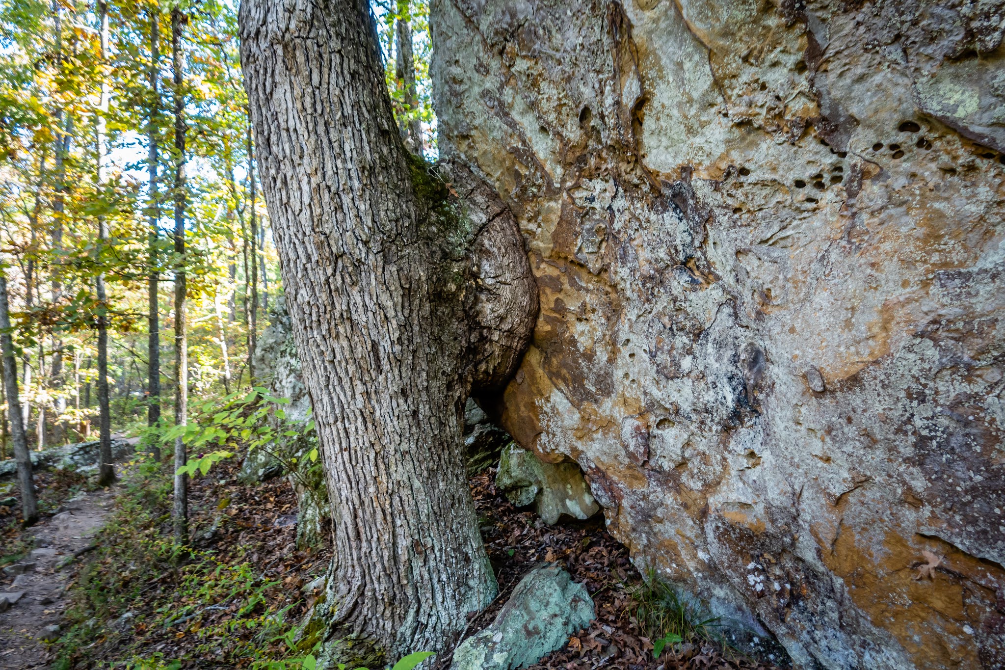
This turned out to be a wonderful hike. It is predominantly a single track trail in a heavily wooded area. There are also lots of rock formations along the loop to investigate. Plus there were half a dozen geocaches spaced around the loop. Along the way, we saw a couple trees next to large boulders or rock walls that seemed to be trying to engulf the rock - much like how tree bark often covers over a cut branch to seal the wound. The one in this picture has a circumference close to 6 feet.

Along the Seven Hollows Trail


Colorful Fungus

Tree Bark Spreading on Rock

One of the more impressive rock formations was a large arch. We ran into a young couple here on their honeymoon and took a few pictures for them posing underneath the arch. It wasn’t as big as those we saw a year ago in Arches National Park but pretty big for Arkansas.

Arch on Seven Hollows Trail

Undercut Rock Wall

Near the halfway point of the trail near the southern end is a spur trail to The Grotto. We figured since we’ve come this far and have enjoyed the hike, we could add the extra half mile to this and back. It a very large undercut rock that forms a huge covered shelter. It would probably make for a good spot to wait out a rain storm. Coming back up the western side of the loop, a geocache pointed out a natural bridge that we would not have even known existed. The trail actually crosses over the rock bridge but most people wouldn’t recognize that fact. It wasn’t until I got off trail to search for the cache did I discover that the underside of the rock is missing and has formed a bridge.

Inside Grotto

Underside of Hidden Natural Bridge

Trail Between Rocks

At one point along the trail, I noticed a dozen or more butterflies all in a small area. One of the trees must have had a wound and had sap running out. The butterflies were quite content to stay still while I got some pictures. It wasn’t exactly clear where the 7 “hollows” were along the trail since we aren’t positive what a “hollow” means in this context but nonetheless it was quite a nice hike that came in at over 5 miles with the additional detour to the Grotto.

Butterflies Have a Treat

Underside of Butterfly Looks Like Leaf

Very Interesting Coloration

Our last full day in the park included a handful of short stops and walks scattered across the park. The first was on the far eastern end of the mountain. Stout’s Point juts out to the east and has a commanding view of a bend in the Arkansas River about 760 feet below. Petit Jean for whom the mountain and park are named has her gravesite in a rock outcropping on the point. Her story is a sad one. A young French woman in the 1700’s disguised herself as a boy in order to come along on a transatlantic crossing with her fiancé. Nobody, including her fiancé, knew her true identity and was called Little John because of her small stature. They ended their journey near this point on the Arkansas River and the crew spent time exploring the area. Before they left to return to France, Petit John got sick, and a doctor discovered her true identity. She asked to be buried on the overlook.

Overlooking Arkansas River

Near Petit Jean Gravesite

Stone Shell of Building 

Our next stop was to Cedar Falls Overlook. This is directly across from our hike two days earlier and does have a better view of the falls but they are still just a trickle.

Cedar Falls Overlook

Stone Pillars and Wooden Fence

The Mather Lodge is another stop in the park. Rather than driving to the lodge, we take the hiking trail from the overlook. This lodge is quite nice. Originally built by the CCC in the 1930’s, it has had additions made to it over the years to enlarge and modernize it a bit, but the general feeling of the place is in keeping with the original CCC style and design. There are cabins near the lodge that can be rented and the views from the patio are great. On our walk back to the overlook parking lot, we walked past the old CCC Water Tower. A beautiful building although it wasn’t exactly clear how it held water.

Mathe Lodge Main Entrance

Interior Room

Main Entrance Hallway

Beautiful Stonework

Lodge View


CCC Water Tower

Next we drive to the Palisades Overlook. This is directly across from the CCC Overlook on Red Bluff Drive. We could just make out the shelter roughly half a mile away.

View at Palisades Overlook

CCC Overlook Barely Visible


We have driven past the parking area for Bear Cave several times but hadn’t stopped yet even with the intriguing name. It wasn’t a long walk but had some very interesting rock formations to explore. The Bear Cave was neat but neither Yogi or Boo-boo were home! The more interesting thing about the area were the many paths that led in between the huge rocks. It was a fun place to explore. Along the way, we stumbled on a pair of walking sticks that appeared to be mating. They were actively moving along a nearly vertical rock face that looked like a precarious spot for such an activity.

Bear Cave

Narrow Path


Walking Sticks Uncensored


Our last stop of the day was at the pioneer cabin. It’s also the trailhead for the Cedar Creek Trail. It’s about a 1.25 mile loop that goes down to the creek, crosses over a bridge and then along the opposite side before hitting another bridge to cross back over and return. I had brought along my DSLR camera which was a bit large for what turned out to be a more challenging trail than we were expecting. It was a pretty hike and there was a little water in the creek. Plus we found the two geocaches that along the way.

Pioneer Cabin

Heading Down to Cedar Creek

Cedar Creek

Bridge Over Creek

Petit Jean SP was a very good stop. Our 4 night stay seemed to be about the right length of time to check out the park. There likely were some other attractions in the area. One that I probably would have opted to visit during non-Covid times was the Museum of Automobiles which was very nearby. But we enjoyed our stay enough that we might make it back someday.

Our next stop would just be a quick overnight stay at the Harlow’s Casino near Greenville Mississippi. Hurricane Delta had just passed thru the area a few days earlier but there wasn’t any obvious signs of damage. The casino is about a mile from the center of the Mississippi River and appears to be easily within the flood plain of the river. In fact we have to drive up and over a levee to get to the parking lot. Seems like a dangerous location to build such a large place. We feel confident we will at least survive the night without floating away. We only had one other RV join us for our stay. Since neither of us are into gambling, we didn’t even feel the need to go inside. The rain we had overnight was gone by the time we left and we had a fairly nice day to tackle the 240 mile drive to Hattiesburg Mississippi.

Our destination was the Hattiesburg Elks Lodge. Reviews we had read about this place was a combination of good and bad. It sounded like the camping spots were in an absolutely gorgeous location next to an 80 acre lake. However almost every visitor commented about how nearly all the sites are not even close to being level. We called the day before we were to arrive to get a gate code in order to enter the grounds. The lodge is on the south side of town in a fairly rural area. After getting thru the gate, we drive a mile before we see the lodge. The road is nicely paved although there is a water crossing at a spillway on the south end of the lake. The water was only an inch deep and not running very quickly.

The campground is a third mile beyond the lodge. We stopped and unhooked the Jeep and then investigated the campsites with the hope of finding a reasonably level one. Most of the rigs here are small travel trailers but there are dozens of open sites. There was one motorhome larger than us in the only very level site. We found one that we hoped to make work. It did take us every leveling block we had but got setup. We checked out the lake and dock. I suspect many of the members from this lodge keep a trailer and boat here and come whenever they have the opportunity. It is one of the nicer Elks camping areas we have stayed at if only they could do some work on making the site more useable by larger rigs like ours.

Unlevel Site in Hattiesburg ...

... But Beautiful View

We didn’t have any firm plans on what we wanted to see in the area but planned on staying two nights in order to have a full day to do something. That evening we investigated what hiking or biking trails were in the area and stumbled upon the Longleaf Trace Trail. It’s a 44 mile paved rail-trail that starts in downtown Hattiesburg and heads northwest through a series of small towns. We decided to find a trailhead a bit outside of town to make sure there was adequate parking. We packed a lunch, loaded the bikes on the rack and headed to the Jackson Road Station.

Longleaf Trace Map

It was a busy location but probably understandable given it was a very nice Saturday morning. Our starting point was roughly at mile marker 7 and we head west. There are numerous geocaches places along the trail so we have occasional breaks in the ride. The trail is quite nice - wide, smooth asphalt and generally shaded presumably by the Longleaf Pines. The trail is very slightly uphill for the first 10 miles rising about 100 feet. This makes for an easy ride. There are benches along the way to stop and relax if needed. There was even a multi tiered platform overlooking a beaver pond that became the ideal lunch spot.

Old Glory Along Trace

Beaver Pond

Turtles at Beaver Pond

We continued out until the Sumrall Station and headed in town for both a geocache and an ice cream cone. The cache was found but a place for ice cream wasn’t. Even though the weather and trail were great, we decide it’s best to head back so we don’t wear ourselves out. That last ten miles back to the car was quite nice with the gradual downhill to aid us. We ended up getting in over 23 miles and would love to do more of the trail further west but we’re on a schedule to get to our next stop in Florida. Maybe by the next time we make it back here, the lodge will have leveled the camping sites and we can stay a bit longer.

Mardi Gras Tree?