Map of this blog's locations click this link to open the map
Our next destination is another Ohio State Park campground. West Branch SP is just outside of Ravenna Ohio and only about 40 miles from where I was born and raised for my first 18 years. I suppose if we had known that our furniture wasn’t going show up, we would have tried to book our campgrounds in a better sequence to avoid crisscrossing central Ohio like aimless Gypsies. But since we were in a “wait and see” holding pattern, that’s how it’s worked out. Fortunately it’s only about 140 mile drive so not too difficult. We booked a full week at West Branch since we had a handful of things we wanted to do in the area.
Our main destination would be another National Park. Cuyahoga Valley NP isn’t as well known as others like Yellowstone or Yosemite, nor is it nearly as old. Designated a National Recreation Area back in 1974, it didn’t become a National Park until 2000. Possibly the most unique aspect of this NP is its proximity to two major Ohio cities. The 32,500 acres covers 17 miles between Akron and Cleveland and follows the valley along the Cuyahoga River as it makes its way to Lake Erie. Being such an urban area, we were unsure what to expect. So we watched numerous YouTube videos and read blog posts to get a sense of what were the must do things in this park. Depending on which part of the park we wanted to visit, the drive would be around 30 to 40 miles. There aren’t a lot of camping options in the vicinity of CVNP so we concluded West Branch SP would be a good home base for the week.
 |
| Boston Mills Visitor Center in CVNP |
We came in on a Thursday afternoon and got settled before some rain rolled thru the area. We knew that we should avoid CVNP on the weekend so when the rain cleared, early Friday morning, we headed over to check out a few of the places that made it to our list. First stop was Brandywine Falls located on the eastern edge of the park near its middle. It was a cool and overcast morning which helped to reduce the number of visitors. There is a long, elaborate wooden staircase and boardwalk that goes down into the gorge following the rock face side to a couple viewing platforms. The wet wood was a bit slippery but we made it without incident. Brandywine Creek was flowing pretty well from the rain overnight and made for a pretty spectacular view as it drops the 86 feet at the falls.
 |
| Pathway Follows Rock Face |
 |
| Brandywine Falls |
 |
| Bluebells in Bloom |
 |
| Falls from Different Viewpoint |
Since the weather seemed to be improving and the sun was trying to come out, we decided to continue along the Brandywine Falls Loop Trail. The short option is just under 2 miles. It first crosses over the falls where there is the beautiful Inn at Brandywine Falls. Built in 1848, it was the home of the owner of some of the mills that used to operate on the creek. Today the National Park owns the home but leases it out to be run as an inn for travelers. The backyard had a couple of sheep wandering around the yard. Marigold and Buttercup even came over to the fence as we approached.
 |
| "Lawn Mowers" Working the Inn at Brandywine Falls |
 |
| Could Use a Bath |
The trail continues along the northern side of the creek as it works its way downstream. There are lots of wildflowers blooming along the sides of the trail. A long footbridge takes us back over the creek before we start the climb back up to the parking area. A set of wooden steps built into the side of the hill makes the climb a little less dangerous.
 |
| Clinging to the Edge |
 |
| More Bluebells |
 |
| Footbridge Over Creek |
 |
| Brandywine Creek |
 |
| Wooden Stairs Set in Hill |
It was lunchtime when we got done, so we headed over to the nearby Boston Mill Visitor Center. It is one of several visitors centers but the only one open during COVID. After lunch, we did a quick tour of the visitor center and asked the rangers a few questions about the railroad system that operates with the park. Presently it is only operating a few days a week so it doesn’t look promising we will get to try it out during this trip.
 |
| 3D Model of Park |
Our next destination was the Ledges Trail. From all we heard, this was the best hike to take in CVNP. It isn’t necessarily the easiest trail but it is only a 2.3 mile loop. The trail circles a massive rock formation with all sorts of crevices and narrow passageways. It’s not required to walk thru the crevices, in fact several of them are specifically marked as closed. It when I got the chance to try some of them out, I had to give it a shot. Even if you simply walk the loop as intended, the huge rock formations are really neat. Most of them covered in moss or lichens.
 |
| Looking into Crevice from Above |
 |
| More Crevice |
 |
| Trail Follows Rock Wall |
 |
| Chris Dwarfed by Rock Wall |
 |
| Gap in the Wall |
 |
| In a Crevice |
Towards the northern end of the loop was a sign for the Octagon Shelter. It sounded interesting so we did the quarter mile detour to check it out. It was a old style shelter with a massive stone fireplace with 8 sides (although two of the sides had wings). While it was nice to see, I don’t think it was worth the extra energy to check it out.
 |
| Octagon Shelter |
As we continued along the rest of the Ledges Loop, I found myself stopping frequently to just marvel at the massive rock formations with large trees attempting to make their home while barely clinging on. At one point the trails opens up to an overlook although the trees made for a mediocre view. An impressive stone staircase was built by the CCC as a way to get back up to the top of the loop as it heads back to the parking lot. I thought the shelter near the Ledges parking lot was a more interesting design.
 |
| Overlook View |
 |
| Impressive Stone Staircase |
 |
| Shelter Near Ledges Parking Lot |
We had a little more energy left before we headed out so we stopped at the Beaver Marsh. This section of the Towpath Trail thru the park has a boardwalk that goes over a small pond/marsh area. There were lots of birds, turtles and fish to check out. It was just a short walk but a pretty stop. We left the park and headed to a Skyline Chili that we managed to work into our route back to the campground.
 |
| Green Heron |
 |
| Turtles Lined Up |
 |
| Sunbathing Turtle |
 |
| Blue Heron |
For Saturday, we headed to Kent State University to wander the campus and get a few geocaches. We figured it would be quiet and the parking should be easier. We often enjoy exploring college campuses during our travels. This one has a bit more history behind it than others. We would be visiting a few days after the 51st anniversary of the shooting of 4 student protesters by members of the Ohio National Guards. A quick stop at the memorial to pay our respects then a mile or so of walking the campus. I’m not sure what the class schedule is but there didn’t seem to be more than a few students on campus. There are some interesting buildings but Brain Plaza may have been the most unusual place we saw.
 |
| Overlooking Memorial Site |
 |
| Great Architecture |
 |
| Big Brain |
 |
| Concrete Bookcase and Bench |
Not far from campus is the Cooperrider-Kent Bog State Nature Preserve. Maybe it’s name doesn’t roll smoothly off the tongue, but the 1/2 mile boardwalk loop thru the bog was a relaxing place to check out. Lots of flowers were in bloom. Dozens of interpretive signs along the way helped explain all sort of things regarding flora, fauna and geology of the bog.
 |
| Follow the Boardwalk |
 |
| Blueberry Bush Blooming |
 |
| Flooded Area of Bog |
Another storm was coming thru Mother’s Day with all day rain expected. I had already promised myself I would take advantage of being this close to “home” to visit the graves of several important women in my life. So off we went with raincoats and umbrella ready. The first stop would be Louisville where my maternal grandparents are buried. My grandfather had died years before I was born but I actually lived in my grandmother’s home during the summer after my freshman year at college. I suspected this would be the most challenging grave for us to find since I was last here for her funeral back in 1988. But we had the name of the section, and after a bit of circling we found the proper section and spotted the grave marker fairly quickly. Next would be Canton. My mom, dad and paternal grandparents are all buried near one another, and I tend to stop here whenever we happen to be in the area. The last stop was North Canton to visit my sister. Our visit would be one day after the 19th anniversary of her passing. I tried not to let the rain dampen my memories of them on this dreary Mother’s Day.
The following day was a bit nicer and West Branch has some hiking trails to try out. Plus there are 15 geocaches along the trails that start just outside the campground area. Just because the rain had stopped and the sun was out didn’t mean the trails would be fine. There were lots of muddy sections from the more than one inch of rain we received. Fortunately there weren’t any sections that were impassable although one of the caches was on the other side of a small bay with no trails leading to it. We opted to just ignore that one and settle for 14 finds in our 5 mile hike. On the way back to camp, we stopped at the RV dump station and used the hose to rinse off all the mud.
 |
| Heading Down Trail |
 |
| Kirwan Reservoir |
 |
| Flowering Dogwood |
 |
| West Branch Campground |
When Chris was poking around the geocaching maps, she had discovered a couple of parks not too far away that had lots of caches with many favorite points. We often use the favorite points other cachers have awarded a geocache as an indicator of how fun it might be. First stop was Maple Grove Park just northwest of Hudson Ohio. This is one of those small parks that can only be accessed from a cul-de-sac of a residential area. Several of the caches hidden in this park are known as field puzzles. These are caches that require some effort (usually mental effort) in order to open them. The ones in this park look like bluebird houses on a 4x4 post with a four digit combination lock. The goal is to solve the puzzle to get the combo and open it to sign the logbook. The first one did not set a good precedent for us. The three visible sides of the box had several grids of numbers in different colors. We are both fairly technical people and can usually figure things like this out. But after trying dozens of “oh how about this?” Without getting in, I had to resort to brute force. Fortunately there were some clues in the cache description and it only took me a couple hundred attempts to find the right 4 numbers. Even knowing the numbers, we still haven’t figured it out but we signed the logbook. The next few went better but there was still one of them that we never figured out and by then we were getting too hungry to try the 10,000 options!
 |
| Difficult Field Puzzle |
 |
| A Gnome Watches Our Every Move |
After eating lunch, we headed to Hudson Springs Park where there were 6 more of these style field puzzles. We apparently have been to this park before since there was one geocache we have already found way back in 2010. Don’t really recall the park, but it is a nice one with a loop around a large pond. There were some more very creative puzzles that tested our abilities. We solved the first 5 but by the time we got to the last one, we were frazzled and hungry and starting to get dark so we called it a day and headed home.
 |
| Hudson Springs Lake |
 |
| Brush Up on Your Braille and Morse Code |
For our last full day, we headed back to CVNP. This time with our bicycles. The Ohio and Erie Canalway Towpath Trail is over 90 miles long and starts to the far south in Bolivar Ohio and ends up north in Cleveland. We have ridden parts of it near where my sister lives in Massillon. Today we want to ride some of the trail that is within the National Park. Chris tells me she has 20 miles available to give. The trail is reasonably flat since it parallels the old canal but the general elevation increases the further south you travel so we figure we will start towards the northern end of the park and head south so our ride back to the car should be downhill a bit. We had heard that portions of the towpath were closed due to flooding so we head to the Frazee House as our starting point. There is a small parking lot at this landmark. A few pictures and then we’re on our way.
 |
| Frazee House |
 |
| Front View |
When we cross the road to get on the towpath, we realize that it appears to be open to the north so we immediately change our plan and head north. We hoped to make it at least to the Canal Exploration Center. We knew it wouldn’t be open yet, but there are some outdoor sights including a “working canal lock”. The trail was in good shape. There were sections where it looks like it might have been flooded recently but was completely dried out now.
 |
| Canal Exploration Center |
 |
| Blossom the Mule |
 |
| Lock #38 |
 |
| Canal Exploration Center Museum |
We continued north. At times the Cuyahoga River is one one side of the towpath and the canal on the opposite side. It is clear this area could be very prone to flooding when the river is high. |
| Heading Along Towpath |
 |
| Cuyahoga River and Canal Border Towpath |
 |
| Pretty Bridge Over Canal |
A bit further north, we stumble upon another trail perpendicular to the towpath. The Hemlock Creek Trail looked pretty so we headed west. It’s only two miles long and quite pretty but it does gain about 250 feet as we head away from the river. We had been lured up the trail by the promise of Hemlock Falls but alas a bridge for the trail goes right over the falls and there wasn’t an obvious way to get to a good viewing point. Near Brecksville Road, we found a huge Cleveland Clinic Technology Center complex. There was a picnic table along the trail and that worked well for our lunch break. |
| Sign Marking Start of Hemlock Creek Trail |
 |
| Overlooking Creek |
 |
| Calm Section of Creek |
The ride back down the hill was much more fun than the ride up. We turned north just to go as far as Lock 39. Then turned around and headed back towards and beyond the Frazee House. That direction was a bit more pleasant since the trail diverges from the busy road. The condition of the canal varies greatly along the towpath from a canal full of water, to a swampy reed laden trough, to a completely dry grassy hollow. There are 40-some locks along the way. We stop at a few of them but aren’t all that impressed. I guess living and biking on the Erie Canal in western NY will do that to you.
 |
| Lock #39 |
 |
| Sign Showing the Many Locks Along Canal |
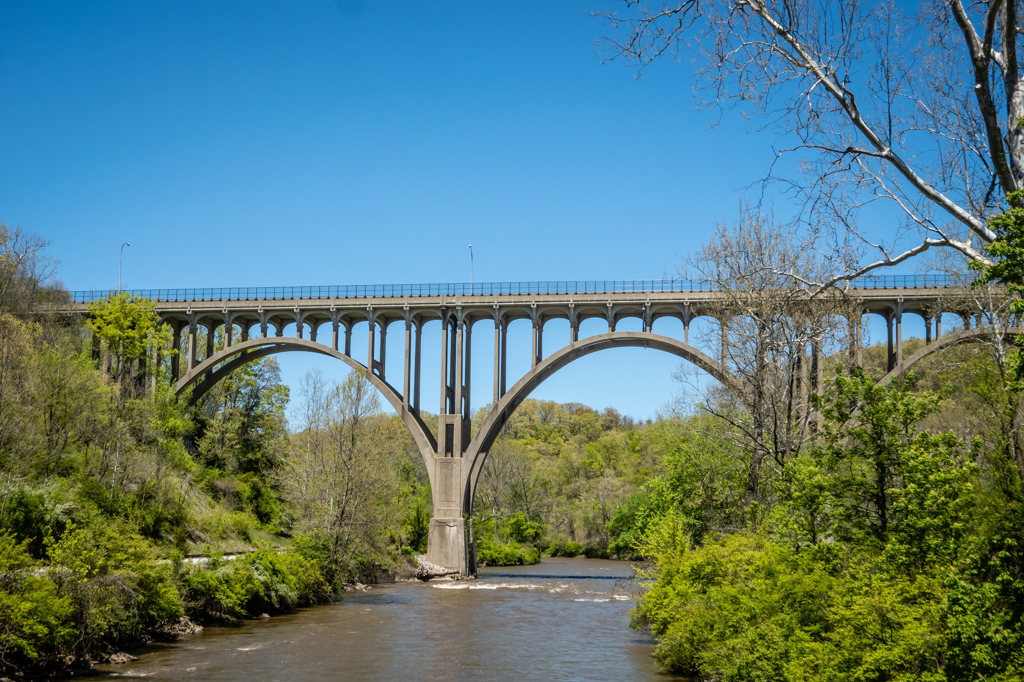
We took another break at the very picturesque Brecksville station. The impressive multi-arch bridge towers over the river, railroad tracks and towpath. We decide to head a bit further south and turn back at the Boston Visitor Center. By the time we made it back to the car, we had done 5 miles more than Chris’ limit but I think she still enjoyed it. It would definitely be fun to do more of the ride through the park and then use the railroad one way option to get you and your bike back to the starting point - maybe next time?
 |
| Station Road Bridge Built 1882 |
 |
| Brecksville Station |
 |
| Another Bridge View |
 |
| Turtles |
 |
| Big Snapping Turtle |
Spending just two full days at CVNP gave us a chance to see some of the highlights. This is a big enough park with such diversity that a few more days will be in order. It is hard to believe a place like this can exist in such an urban area. Coming back after COVID is in the rear view mirror should work out better. Something else to keep on the list.
We had one more stop to make before we start the journey south to Asheville NC. Our goal is Norwalk OH. What is so interesting in Norwalk you ask. Well the state of Ohio has 88 counties located in it. Over the past 11 plus years of geocaching, we have managed to find at least one geocache in 86 of the counties. The two remaining are side by side in north central Ohio. Norwalk happens to be in one of those counties and there is an Elks Lodge there that permits overnight RV parking. So our goal is to drive the 92 miles to Norwalk and get in early enough to go out to find a geocache in each remaining county. The cache I picked to do in Seneca county was one with a fair number of favorite points and turned out to be on the grounds of the Sorrowful Mother Shrine. I’m not a religious person but the grounds of this facility are awe inspiring. There is a large open air chapel (ideal for COVID times) and a series of walkway with dozens of small shrines.
 |
| Sorrowful Mother Shrine Grounds |
 |
| Our First Completed State - Ohio's 88 Counties |
By the time we got back to the lodge, the place was open and I was able to go in and register with the bartender. The place has no utilities but dry camping for a night isn’t an issue. They were back to having the kitchen open and Chris and I decided to have our first indoor dining experience in 14 months! It was just the two of us, the bartender and the cook for most of the time. Later a handful of locals came in for an initiation ceremony they were having that evening. The ER (exalted ruler) for this lodge introduced herself and even gave us a tour of the place. They have a beautiful 14 acre lot with a large pond and seating area outside. It was a very quick stop but it worked out to accomplish our mission.
 |
| Grounds Behind Norwalk Elks Lodge |
 |
| Elks Lodge View from Pond |