Map of this blog's locations click this link to open the map
With our Jeep repair behind us, we are left with 5 nights before our month-long reservation in Maine. Our original plan was to spend a week somewhere in the White Mountains of New Hampshire as we head east. We drive along US 2 for much of the trip. It’s a pretty drive although there was a fair amount of construction along the way. One portion was a quarter mile of single lane with no pavement. Not the most fun but not too rutted. We opt to stay at Twin Mountain RV Park just outside of Bethlehem NH on the northwestern edge of the White Mountains. It’s a nice park with full hookups and cable although they only have 30 amp electric service.. Having spent the last 24 days with only 30 amp and no water or sewer, this place will seem like a luxury resort! The park isn’t very big with only 18 sites, but they are all pull thru with room enough to easily get in and they had sites available for our stay.
The weather forecast for our first full day was for rain. Not necessarily the best for a lengthy hike up any of the numerous mountains in the area. We pick a trail on what used to be Lower Falls Road along the Ammonoosuc River. We had noticed a string of geocaches that was only 5 or 6 miles away. It sounded pretty. I suspect the road was washed out by the nearby river and they decided to close it to vehicles but leave it as a trail. The big parking area near the trailhead looks to be used for boondocking and might be okay but it is close to a fairly busy road. It turned out to be a nice walk. It has numerous access paths down to the river and we were surprised by the number of other people out this morning for a walk, or fishing. The trail is only about a mile long before the road picks up again for vehicles. The "falls" along the river here are not much more than what I would consider rapids but it was still a nice place.
 |
| Lower Falls on Ammonoosuc River |
 |
| Calmer Section of River |
Our early start to beat the rain meant we were done with this pretty quickly and the skies didn’t look threatening so we headed to a bit of a mountain hike. Sugarloaf Mountain is also nearby. It’s not one of the 4000 footers that the White Mountains are famous for, but it will do. It is a 3.3 mile round trip hike with just over 1000 feet of elevation gain and we hope it will be a quick enough hike to avoid the rain. The parking area was nearly full when we pulled in but we got a legal parking spot and started up the trail. The first half mile isn’t very steep or strenuous but then it starts to climb enough that we notice it. After another 0.4 miles, we hit a split in the trail. Head to the right to go to North Sugarloaf or left see Middle Sugarloaf. We shoot for North Sugarloaf first since its only about a quarter mile from the intersection.
 |
| Trillium Seedhead |
We didn’t have the trails to ourselves but it didn’t feel too crowded as we hiked up. The views from North Sugarloaf were pretty nice as we tried to figure out what mountain was what. We think we isolated Mount Washington but couldn’t be 100% sure. It didn’t take long to get back to the fork in the trail and we still felt fresh enough to go for Middle Sugarloaf. This is the higher of the two peaks but the hike up didn’t seem too tough. There were many more people up at the top when we got there. The peak has a mostly open terrain with plenty of room to roam about the exposed rock and not feel too crowded. The views are quite nice and we check them out from all directions. After a brief rest and finding one geocache up there, we start our trek back down. By the time we return to the parking lot, it is packed and people are parked all along the sides of the dirt road that led us here. It was a nice hike and we get back well before any rain arrives.
 |
| View from North Sugarloaf |
 |
| Steps Approaching Middle Sugarloaf |
Our friends from Warren PA figured out where we were and informed us that there were a couple caches nearby that a fellow geocacher we know had placed. We figured it would be a good morning to try them out. After finding the two caches and even though it looked like rain, we next headed to a rail trail that was just down the road from our friend’s caches. The Presidential Range Trail follows an old railroad bed and we picked it up roughly 2 miles from Pondicherry Wildlife Refuge. There were only a handful of others out on this gloomy morning. We had good luck with the caches and even better luck with the weather. There is a small boardwalk that overlooks the pond in the refuge. The trail continues on for miles and looks like it would be a good place for a bike ride since the trail is in excellent shape.
 |
| View from Boardwalk |
By the next day, the rain had cleared out and we had beautiful weather. We picked out one of the more popular hikes in the area. Mount Willard isn’t one of the forty eight 4000 footers but is popular because it’s a relatively easy hike - 3.2 mile round trip with just over 900 feet of elevation gain. Plus it supposedly has great views from the top. We head to Crawford Notch to the AMC Highland Center Lodge. This place is part of the Appalachian Mountain Club and is a rather nice facility. They have rooms that many hikers use as their base camp for exploring the area. We park nearby and just briefly check it out before heading to the trailhead for our hike. The guide for this hike rates it as moderate and heavily trafficked and we can definitely attest to the second part of the statement. There was a geocache near the trailhead, but so many people kept streaming by us that we just gave up and headed up the trail.
 |
| Part of AMC Highlight Center |
I’m sure the fact this was a Sunday, with nice weather, had a huge impact on the number of people out for this hike. We hike a lot and I didn’t really think of ourselves as hiking snobs, but this trail had way too many people on it and most of them seem to have little regard for trail etiquette. Halfway up the trail, I was wishing we were on some remote, nearly desolate trail where you felt you had the whole woods to yourself. We had better luck with the several caches hidden along the way up and in short order we made it to the peak. There were easily 60 people up here but the open area is large enough that we could all have a spot on the exposed rock and not feel too crowded.
 |
| View from Mount Willard Looking at Crawford Notch |
 |
| Other Hikers at Mount Willard |
The view is definitely outstanding. It looks south into Crawford Notch with a road and railroad in the base of the notch and mountains on either side as far as the eye can see. While snacking on some grapes, we hear a train whistle and sure enough, one of the tourist trains is making its way back north to the train station near the trailhead. From our vantage point 900 feet above the train, it looks quite small. As it heads over a bridge, it slows to a crawl, probably to allow its passengers to take pictures. We eventually make our way back to the trail and start the descent. There are still a lot of people, but it’s much easier to pass them going downhill!
 |
| Train Passing Over Bridge |
 |
| Train Back at Terminal |
We spot a picnic table near the parking lot and one of the lodge buildings and enjoy our lunch while we decide what to do next. The Mt Willard hike hadn’t completely drained us of our energy so we headed south to the Arethusa Falls Trail. This trail comes in at 2.7 miles and 860 feet of elevation. Partway up the trail is a split. The trail to the left goes along Bemis Creek and picks up the main trail again in half a mile. We picked the Bemis Creek path and are glad we did. There are numerous stops along several small waterfalls as we continue up. We stopped at all of them to check them out and get some pictures. We found the number up people on this side trail to be quite low which made for a more peaceful hike. As a word of warning: if you want to try this trail, it’s worth it, but do it on the way up since there is a really steep climb towards the end to get back onto the main trail. It would be a very challenging trail to do going downhill on the way back.
 |
| View at Trailhead for Arethusa Falls |
 |
| Bemis Creek |
 |
| Small Falls Along Bemis Creek |
 |
| More Bemis Creek |
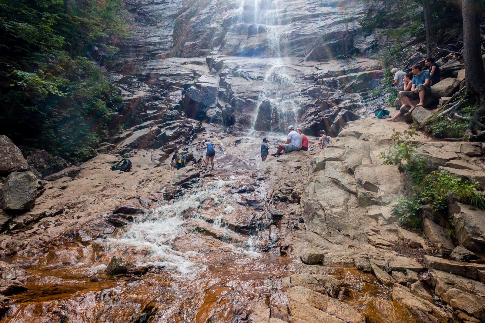
Back on the main trail, we worked our way up to Arethusa Falls. The last few hundred feet seems to be more of a scramble them a trail. There were several dozen people at the falls and it becomes more of a matter of how much rock hopping you want to do and how close you want to get. We stopped at a couple different vantage points and as people left, we worked our way closer to the falls. We had been led to believe these were the tallest falls in New Hampshire at about 140 feet, but it’s not clear that’s the case. Maybe they are the 2nd tallest in the state? In any event, the falls are nice but Niagara Falls they aren’t. I played around with some slow shutter speeds, but without a tripod, they were limited. We headed out after a lengthy stop at the falls and by the time we got back to the car, we were definitely tired. Seems like the goals of,our hikes are to see something interesting and wear ourselves out in the process - mission accomplished!
 |
| Approaching Arethusa Falls |
 |
| Others Enjoying the Falls |
 |
| Side Shot of Arethusa Falls |
The White Mountains has been added back to our bucket list. Four days wasn’t nearly enough time to see and do all the things we would have liked. If we didn’t have reservations in Maine, I could imagine spending at least a month here if not longer. Would we be able to do all 48 of the 4000 footers in that length of time? Probably not, but it would be fun to try. We have both read the book Following Atticus by Tom Ryan about a newspaper reporter that hikes all 48 of the 4000 footers in the White Mountains in the winter with his dog. We are serious hikers but not that hardcore - maybe we could do half of them in the late summer and early fall?
 |
| A Stop at Saco Pond by Willey House |
 |
| Bridge Over Small Dam |
We have about 220 miles to go for our extended stay in Maine. We pick the Elks Lodge in Farmington Maine at roughly the halfway point to break up the drive. Not too surprisingly, we were the only ones there for the night. The bartender was nice and turned on one of the outside electrical outlets but we ended up having trouble with its wiring. This was the first lodge we’ve stayed at that truly means they take donations. They don’t have a fixed charge, donate what you feel is appropriate. Next to the lodge was a former wood turning business. The cyclone vacuum system they used was pretty impressive. I suppose we should be grateful it’s closed otherwise it would be a very noisy camping spot. We walk to a nearby park for a geocache and to check it out. For dinner, we find a Mexican restaurant near the college campus in town. When we get back to the lodge, the parking area is very crowded with cars. It was bingo night and they had a pretty good crowd. After bingo was over, the place turned out to be a nice quiet spot and better than the Walmart on the other side of town would have been.
 |
| View at Elks Lodge |


No comments:
Post a Comment