Map of this blog's locations click this link to open the map
As we were making our travel plans for the route to Colorado, we had decided to try coming across Nebraska since we hadn’t really explored that state yet. We had picked Omaha and North Platte as two places we wanted to check out. The most direct route from North Platte to Colorado would have been across I-80 to I-76 and into Denver. Another option would have been I-80 into Cheyenne Wyoming and then down I-25. But we had noticed a national monument in far western Nebraska. We did a little investigating into Scotts Bluff National Monument and found it looked interesting enough to do the slight detour from the direct routes to Colorado and spend a few days in the town of Scottsbluff Nebraska. And before you ask, it isn’t clear to me either why the monument and the town aren’t spelled the same.
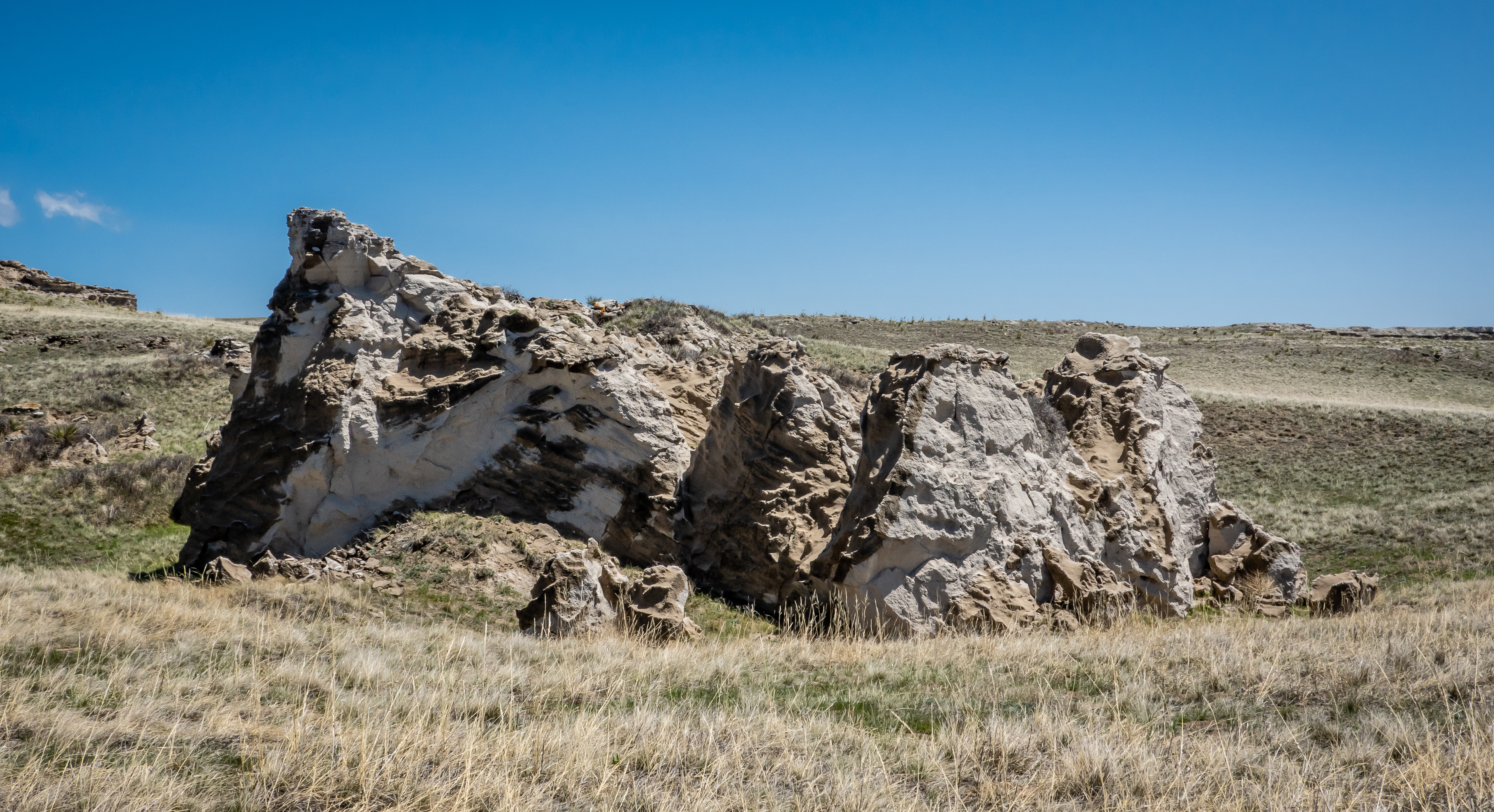
I doubt that Scottsbluff is a big tourist destination. There aren’t many campgrounds in the area but Riverside Campground is fairly close to the monument and had availability for the nights we wanted to stay. It’s just over 200 miles from North Platte to Scottsbluff and much of the drive was similar to the rest of Nebraska - mostly flat and nondescript. About 40 or 50 miles from our destination, we began to see large rock outcroppings in the distance. It was interesting to watch them as we got closer. They appeared to be isolated occurrences jutting up from the reasonably flat terrain that surrounds them. We were optimistic that there may actually be some unique things to see in this part of Western Nebraska.
There were plenty of available sites at the campground so we picked one and got situated for the three nights we planned on staying here. We took it easy for the rest of the day and headed over to the national monument early the next morning. It’s hard to miss this place. There are numerous large rock features in the immediate area. The visitor center is located near the entrance so we stopped here first to learn about Scotts Bluff.
There is a movie and a number of exhibits about the area with much of it centered around the pioneers in covered wagons that passed through this land in the 1800’s on their journey west. Obviously there were also lots of displays on the geology of the bluffs. I enjoy learning about this stuff, but must admit that I have a hard time wrapping my head around events that occurred several million years ago. After thoroughly exploring the visitor center, we headed out to do one of the short trails that wanders past the very large Eagle Rock. There is a covered wagon replica with half a dozen oxen hitched up. This trail also provides a good viewpoint of the South Bluffs on the other side of the road. It doesn’t appear to have any developed trails so it’s not possible to get up close to that part of the monument.

It seemed like most visitors simply walked a few hundred feet to see the oxen, wagon and get a picture or two of Eagle Rock, but the trail actually continues on past this feature and wraps around the opposite side. It is a half mile (one way) from the visitor center to the end of this trail. From here we can actually start to see the tunnels that were built in the 1930’s to allow a 1.6 mile road to climb to the top of the bluff. The views from this trail are rather nice and is worth the effort to climb the 100 feet in elevation.


Back at visitor center, we have two options to get to the upper overlooks on the North Bluff - walk or drive. Both are 1.6 miles long but there is a 500 foot elevation gain. We pick the easier route and drive. It is pretty neat to drive through the three tunnels that make up the drive. None of them are very long, maybe 150 feet max. There is room for a couple dozen cars up top. There are two trail options from the parking lot. Neither are very long. We start with the South Overlook Trail. This trail gives a good view of the Saddle Rock Trail - the one from the visitor center. There is a tunnel associated with this trail as well but we will only get to see it from a distance.
The south overlook gives a great view of the visitor center and the road we just drove up as it enters the first tunnel. The area inside the loop of the road had been burned not long ago. It wasn’t clear why they would do a prescribed burn in an area that seem almost devoid of vegetation already?
Next we head back to check out the North Overlook. From this vantage point we can see Riverside Campground and can almost make out our rig thru the trees. There are definitely some nice views from here as well. Not all the vegetation is dried up, there were a few patches of flowers here and there along the way. Down below was a very long train heading west. Undoubtedly this one was coming out of the Bailey Yard in North Platte. It took a long time before it was out of sight. They have several arrows affixed to the rock wall at the overlook that point out distant features. One of them is Chimney Rock, 20 miles away. That’s where we will head next.

Chimney Rock is about 25 miles east of Scottsbluff. It’s pretty obvious on the horizon as you head towards it. It stands just over 300 feet tall over the surrounding terrain and has a rather unique spire that rises from the rest of the rock. The spire itself is about 120 feet tall.
There is a museum and visitor center that is about 3/4 mile from the actual rock. All the reviews we read made it sound like the museum wasn’t all that great and being that far away, the view wasn’t particularly better from that location. We knew there was a geocache down an dirt road near the Chimney Rock Cemetery. This is a bit closer at about half mile away plus there is a small trail that heads even closer to the rock. We walked a bit of the trail but it was rather uneven and steep in sections. Since we knew we wouldn’t be able to get right up to Chimney Rock, seeing how close we could get didn’t seem to make much sense. I suspect the pictures I took from 1/3 mile away are just as good as I would have gotten if I was one tenth mile.
Another reason for heading out from Scottsbluff was to find some geocaches in surrounding Nebraska counties. Since we likely won’t make it back to this part of the state, we should get them now. We headed another 20 miles or so to the southeast to another rock formation - actually two side by side. Courthouse Rock and Jailhouse Rock sit side by side pretty much in the middle of nowhere. They jut out about 400 feet from the surrounding ground so they are rather impressive. |
| Courthouse Rock |
 |
| Jailhouse Rock |
 |
| Jailhouse Rock at Different Angle |
We were somewhat surprised that we weren’t the only people here. There really aren’t trails per se that lead up onto these rocks but that didn’t keep two women and a seven year old girl from climbing partway up Jailhouse Rock. We watched from several hundred feet away thinking this might not end up well but they slowly and safely made their way back down after they had gone as far as possible without climbing gear. It’s a neat place but not a must see thing. As we drove back down the road and head to the west, we were able to get a couple different vantage points that have a completely different look to them.
 |
| Courthouse and Jailhouse Rock |
 |
| Another Angle |
As we drove west on Nebraska 88, there were many other rock formations all lined up to the north of us. Our map tells us one of them is Castle Rock but we weren’t positive which one specifically is so named. A storm front was starting to move in and this made for some dramatic scenes. Western Nebraska looks more like South Dakota or Arizona landscape other than the large amount of green vegetation here. As we pulled back into Scottsbluff, the dark storm clouds were immediately over the monument making for a surreal look. We actually made it back before the skies opened up.
 |
| Cattle with View of Possibly Castle Rock? |
 |
| Another Rock Outcropping |
 |
| Doesn't Look Like Nebraska |
 |
| Storm Over Scotts Bluff |
Having completed the rock formation tour on our first full day, we had one more day to explore the area. There is actually another national monument about 50 miles north of Scottsbluff. Agate Fossil Beds National Monument is in the middle of Sioux County Nebraska. This part of the state is quite remote. The county has almost 1300 residents in its 2067 square miles which means on average each person has just over 1000 acres! I would say it’s a rather desolate location. It was a pretty easy drive up Route 29. I think we saw a car or two along the way. There were several large patches of snow along the road - drifting from a snowstorm that hit the area a couple weeks earlier. We hope we won’t run into any snow storms during our trip in Colorado.
 |
| Entrance Sign at Agate Fossil Beds NM |
Other than the signs along the road, it might be easy to miss this place. The mounds and hills in the monument look just the same as those we saw for many miles of our drive. The visitor center is over 3 miles back a side road so there aren’t even any structures that can be see from the road. We weren’t the only people here but the place was far from crowded with less than a handful of vehicles in the parking lot. It’s not clear how the monument’s trailer is used but it does have a nice wrap showing dinosaurs.
 |
| Visitor Center |
 |
| Fancy Trailer |
We head into the visitor center and watch a short movie about the history of this place. Fossils were first discovered here back in the late 1800’s and has expanded over time as more fossils were discovered by various researchers. Even today, scientists are working within the monument and it appears there is housing here to make their work easier since the nearest motel is likely 50 miles away. There are many dinosaur skeletons in the main lobby with lots of other information displays. One large section of the visitor center is dedicated to one man - James H. Cook. He lived in the Niobrara River valley around the turn of the 20th century. Apparently he had a great rapport with the local Native Americans and there are numerous gifts on display that he received over the years.
 |
| On the Hunt |
 |
| Fancy Painted Hide |
 |
| Beautiful Moccasins |
The one thing in the visitor center that really peaked our interest was something called the “Daemonelix” - or the devil’s corkscrew. These spiral shaped fossils were found here in 1891 and initially were believed to be the large taproots of some plant. Over a decade later, new evidence pointed to the spiral being the burrows dug by prehistoric beavers.
 |
| Daemonelix Description |
Done with the visitor center, we head out to explore the interpretive trails. The one closest to the visitor center is the Fossil Hills Trail that leads up to a couple of hills where many of the fossils have been discovered. Being nearly 3 miles and rather chilly and windy, we opted to do the other trail closer to the main road.
 |
| University and Carnegie Hills |
The Deamonelix trail is a 1 mile loop that goes past the hills where the spiral fossils were discovered. There are several geology stops along the way trying to explain the various rock formations. We see a lot of this type of interpretive sign in our stops but the information never seems to stick. Guess it was better we became engineers instead of geologists.
 |
| Starting Up the Trail |
 |
| Rock Outcropping Along Trail |
 |
| Learn Your Rock Layers |
As we get further up the hill, we come across our first devil’s corkscrew. The front portion has been excavated from the side of the hill and a plexiglass enclosure has been built around it to protect it from human damage as well as the weathering from the environment. As we continue up the hill, the wind is howling relentlessly. Baseball caps need to be removed and held tightly in our hands or else they may end up in Omaha on the far eastern side of the state! From here there are some nice views though.
 |
| Large Devil's Corkscrew |
 |
| View of Surrounding Area |
As we come back down the hill, we are sheltered from the wind a bit and come upon the next enclosure housing more Daemonelix. These are less impressive specimens (since we are experts by now) but there are more of them so they get a much larger building. Agate Fossil Beds NM is so remote that it wouldn’t end up on my list of “must see” places but it wasn’t too far out of the way from Scottsbluff so worth the stop if you find yourself in western Nebraska.
 |
| At the Top of the Windy Trail |
 |
| Another Group of Daemonelix |
We took a different route back with the goal of find caches in a couple more counties. Originally we planned to take the road that goes to the monument 25 miles further to the east. It is listed as a dirt road for the full length and when we had asked the woman at the visitor center, she suggested with the recent snow and rains, it may be a challenging route. She instead pointed out a road that isn’t on many maps which would only require 6 miles of dirt road. Sure enough, her instructions were accurate and we found the short cut. It was a bit soft in spots but never muddy. The advantage to a low population county is there isn’t much traffic so I was able to use both lanes to pick my path through the rough spots. The disadvantage would have been if we had gotten stuck, we may have been there for some time.
This wraps up the travels from Florida to Colorado. Next post will begin what should be 20+ weeks all over Colorado, can’t wait!


No comments:
Post a Comment