The weather has been pretty decent here in western Colorado but we had made reservations for a couple of stops in Utah as we head south for the winter so it was time for us to move on. Our original plans made back in late May were to spend 5 nights in Goblin Valley SP before heading to the southwest corner of Utah for a 2 week stay at Sand Hollow SP near St George. Ideally we would finish up the month of October near St George at other campgrounds or the Elks Lodge. That corner of Utah is at a lot lower elevation and has some pretty decent weather this time of year.
But as we have ramped up our search for a new car we can tow behind the motorhome, we decided we might need to make some adjustments to our plans. There were very few Jeep Grand Cherokee models on dealer lots near St George, but we did find 5 vehicles with acceptable options and colors on various dealer lots on the north side of Salt Lake City. This is a bit risky from a weather standpoint. SLC is around 4300 feet in elevation and while historically they don’t start to get freezing temperatures until early November, there is a risk of bad weather in October. We spent over 30 years in western New York so cold weather and snow isn’t a big deal for us, unless we need to drive the motorhome. We really don’t want an early snowstorm to strand us this far north. Besides the historical weather, we can use the extended weather forecast and see that expected highs are in the mid 70’s and the lows around 50 degrees through the middle of October. We decide to modify our plans by canceling our one reservation in St George and making another reservation at a state park north of SLC.
We had learned about Goblin Valley State Park from a YouTube channel we subscribe to. Even though we watched the video years ago, it had stuck in our minds as a place worth a visit. As we put our plans together for this fall, we saw this would be our best opportunity to add it to our itinerary. Goblin Valley is practically the definition of “middle of nowhere”. It’s only 140 miles from our spot in Fruita Colorado but the last 40 miles are thru some rather desolate parts of Utah south of Interstate 70. The nearest town, Hanksville, is about 30 miles further south of the state park and with a population of 162 I suspect it doesn’t have a lot of things to see and do. From past experiences with television broadcast in Utah, I was half expecting to get some over the air television stations but we got nothing. We also had nearly no cell coverage although we did discover that on rare occasions we would be on a local hike and our phones would connect. I even managed to get a "potential spam" call get thru on one hike - lucky me!
The campground at Goblin Valley is rather small. They have 25 campsites but half of those are for tent campers or really small rigs. They do have potable water and a dump station but no electric. Utah state parks are on a 4 month rolling window for reservations so we booked a site big enough for us at the end of May. It wasn’t clear how much there was to see in the area but we reserved a site for 5 nights figuring we should have no trouble seeing everything in that timeframe. All the campsites have a small shelter with a picnic table. The one we booked was rather nice with a wide paved pad. Since we have no utilities to deal with, we opt to pull into the site so we have a view of the Wild Horse Butte just a quarter mile to the west. We decide to just relax at camp since we aren’t in a rush. By late afternoon the winds picked up and we learned a valuable lesson. This area is covered with fine red dust particles and when a storm whips up, the dust blows everywhere. Even though we were at the rig, we didn’t get in quickly enough to keep the inside from getting covered in a thin layer of red dust. The storm did give us a nice rainbow that framed our rig perfectly so there was some silver lining to it.
Perfect Rainbow Location
Entrance to Park with Wild Horse Butte
The next morning, I woke up around sunrise and was greeted with some pretty spectacular views just walking around camp. During our stay, we would discover that the vast majority of the campers would spend one night in the campground and likely do the view of the “goblins” from the observation point on the south side of the park before heading out again. I suppose this could be a side trip for those traveling to or from Capitol Reef National Park about a 65 mile drive to the southwest of Goblin Valley.
Wild Horse Butte
Sunrise Glow at Campground
Looking to the North from Camp
There are more than ten miles of trails to the west of camp that are used more for mountain biking than hiking and we often see people riding in and out of the campground on their way to these trails. On the first morning, we set off for a hike that starts near the biking area but isn’t one of the biking trails. We could drive from the campground to the trailhead but there is a connector trail that starts from the group campground area so it’s just an extra quarter mile to the Curtis Bench Trailhead. Our plan is to hike the mile out to the end of Curtis Bench, then take a connector spur over to Valley 1 and then back to camp on the Entrada Canyon Trail. It should come in at about 3 miles total. It’s a pretty hike with glimpses into the valley of goblins to the east as well as to some of the impressive buttes to the west while still catching glimpses of the huge Wild Horse Butte back north by camp.
A Glimpse of the Goblins Below
View to the West of Curtis Bench Trail
Beaut Butte View
At the end of Curtis Bench are more views of goblins below. We are really looking forward to exploring these during our stay. We backtrack to the spur trail and start our descent into the valley below. This is a rather unusual trail since it is simply following a gully that drops about 100 feet in its half mile length. There are occasional trail markers so we know we are going the right way. There are lots of sections where the gully is quite deep and narrow. Fortunately it’s dry enough that there are only a couple of muddy sections where we can work our way around without getting stuck in thick mud. There are lots of goblins along this part of the trail with all sorts of different shapes.
Looking Down at Goblins
Follow the Gully
Conjoined Rocks
More Goblins
Long Nose on This One?
We get most of the way down the gully when we hear distant thunder. We had commented about not wanting to be on this “trail” when it is raining and when we look back to the north, there are huge black clouds heading our way. We make it safely into the the portion of Goblin Valley known as Valley 1 and start heading north back towards the observation point. There aren’t set trails in the valley and the idea is to just wander through them and admire the otherworldly nature of what we are seeing. Our problem is we know a storm is approaching and we still have well over a mile back to camp. We eventually spot the shelter at the top of the valley at Observation Point but it’s not as simple as heading there in a straight line. There are lots of small gullies that have been carved over the decades by rain. Many of them are much wider than we can walk over or even jump. So we need to do a lot of zigzagging to get over to the stairs out of the valley.
Dark Clouds to the North
Going Past Valley 1 Goblins
Stairs from Observation Point to Valley 1
With the impending storm, we realize walking back on a trail called Entrada Canyon might be a bad choice. If the rain were to start while we were in the canyon, we may run into a muddy mess or much worse. We decide to simply follow the roads back to camp. We pass the aptly named Three Sisters formation just a tenth mile north of the park road. We do some speed walking and make it back to the rig prior to the rain starting. It wasn’t exactly the hike we had planned but it was still very interesting.
Three Sisters
The rain came and went fairly quickly and we were able to go back out for another hike before dinner. This time we would walk up from the campground back to the mountain biking trailhead and start on a couple of trails to make a decent loop. We pick the Lizard Foot Trail first since it will work along the top of the cliff that is immediately to the west of the campground. At one point along the way, there is a great view of camp about 175 feet below us.
Overlooking Campground from Lizard Foot Trail
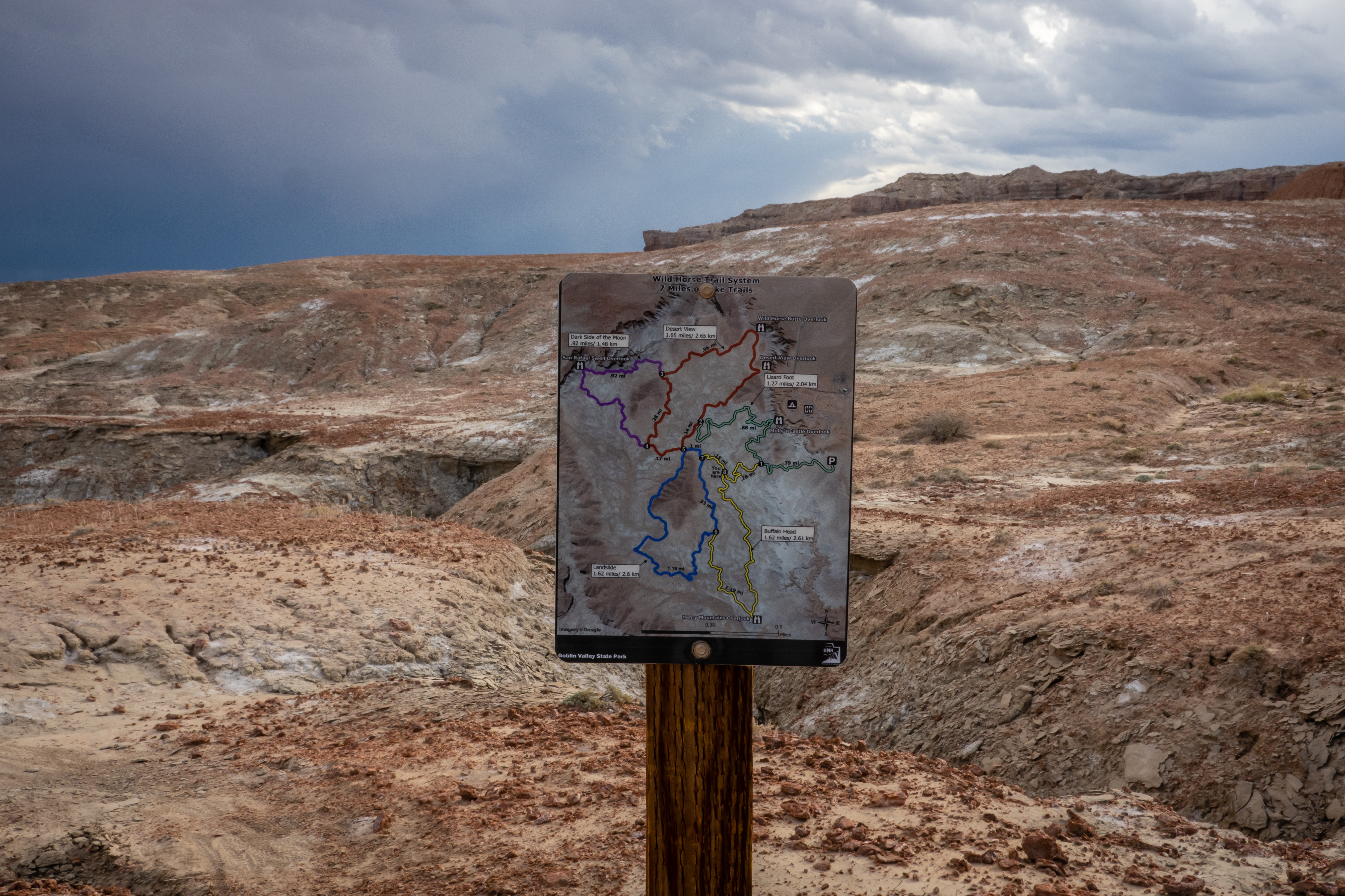
The trail was fine for hiking but all the time I was trying to evaluate whether this would be a good mountain biking trail for me since it is so darn close to camp. There were many sections with very loose rocky conditions that would be tough for me to bike safely. I did see many tire tracks in the dirt, but we didn’t run into any cyclists to see how it’s done. I conclude I would need to walk my bike way too frequently to make this a fun ride for me. At each trail intersection, there is a map with all the mountain biking trails shown so we can easily pick which path we want to take. This part of the park is not nearly as unique as the valleys with the goblins but it was still pleasant. Off to the south, we could see the dark clouds converging and suspected rain might be coming back after dark.
Overlooking Mountain Biking Area
Another Wild Horse Butte View
Trail Map at Each Intersection
More Rain Clouds to the South
Given the remote nature of this park, I knew it would have great dark skies. The only problem is we seem to be getting mostly cloudy nights, so night sky photography isn’t going to work. That evening, we didn’t get rain at camp but there were some very large storms to the north, east and south of us. I sat outside and watched the incessant lightning. All the storms must have been pretty far off since we didn’t hear any thunder but it was neat to watch the skies light up for over an hour.
There was another hike inside the state park that sounded fun. The Goblin’s Lair Trail is a 2.3 mile out and back hike that goes on the east side of the line of hills that creates the valleys that the goblins reside. This trail starts at the observation point parking area and works it’s way to the northeast until it clears the northernmost hill and then it heads south and follows the backside of the line of hills.
View of Goblin Valley from Start of Hike
Need to Hike Around the Backside of This
Coming Around Northern Part of Hike
It was a fairly easy hike once we got down the hundred feet of elevation along the first half mile. On this side of the valley, the hills form a rather impressive line of nearly vertical cliffs. The other oddity is that there are practically no goblins on this side even though there are thousands of them just a tenth of a mile to the west.
Backside of Goblin Valley
About a half mile after making the turn to the south, we are at the sign for Goblin’s Lair. The lair is apparently a cave that is partway up the boulder strewn valley between two of the hills. It wasn’t that far to go from the trail - maybe 160 feet. But in that short distance it gains 90 feet, so it’s quite steep. Chris gave up after a brief attempt. I only went up to look for a cache that is hidden just outside of the cave. There were several other groups of people coming up and down, so I wasn’t able to look for the container without raising some questions. I looked for nearly 10 minutes without any luck. I debated about heading down into the rather large cave but decided it looked fairly challenging and I had Chris waiting for me below. It’s hard to get a sense of scale, but the picture I took from the cave entrance actually has three people walking down below. You’ll need to look closely to even spot them. I slowly worked my way back down to find Chris.
Need to Climb This to Reach Lair
View into Goblin's Lair (note 3 people inside)
Looking Back Down from Lair
Just before getting to Goblin’s Lair, there was a trail sign that pointed in the direction of it but also had an arrow pointing to the trail further to the south. Something called Goblette’s Lair was only 1/4 mile away. It wasn’t on our trail map but figured we should give it a look. It turns out that Goblette’s Lair is the little sibling of Goblin’s Lair. It required another rock scramble but not quite as long or steep. This cave was much smaller and I found I could easily enter it to explore. It likely was less than 75 feet into the hill before the cave just stops.
Large Balanced Rock
Goblette's Lair Up There
Inside Gobblette's Lair
I head back down and we retrace our steps to the north and around the northernmost hill. Instead of taking the same trail back up to the parking lot, we opt to follow the Carmel Canyon Trail. There is a sign at the split designating the start of the trail which basically follows a wash. We knew it came up near the backside of the Three Sisters formation but we’re having a bit of a problem when the wash split to the left and the right. We decide to go left and work our way up the wash.
A Lonely Goblin Outside the Valley
Backside of Three Sisters
It didn’t take long before the wash narrowed down dramatically and had 30 foot tall near vertical walls. We occasionally saw a trail marker so we knew we were on a sanctioned path but it was more intense than we were expecting. There were a couple of spots that were so narrow that I needed to remove my water bottle carrier on my back so I could walks sideways to get thru the tight section. Our next dilemma was when we came upon a steep drop off we needed to climb. It was over 6 feet tall and there weren’t really many good ledges to place a foot or hand to climb up. It took us a bit but we made it. The tough section was likely only a quarter mile or so but it took a lot out of us. We were glad when we came around a corner and saw the top of the shelter near the parking area. It was still another quarter mile away and up a steep rocky wash but at least we weren’t in a tight slot canyon. As we got up to the main trail, a couple of people asked if we had come up a trail but we suggested they might want to pass on this part of the hike. Our morning hike was just over 3 miles and quite the adventure.
Narrow Slot Canyon with 6 Foot Climb
Made It to the Easy Part
Another Goblin View
We’ve been at Goblin Valley State Park for a few days now but really haven’t explored the goblins. I guess I also haven’t explained what goblins are. In most other parks we’ve been to, these geological formations would be called hoodoos. They are rock spires that form from erosion and are created when an upper rock layer is harder and less prone to erosion than the rock layers below it. The upper rock acts like a hat and slows down the erosion of the softer layers below it. But it doesn’t eliminate the erosion of the softer rock below, so many of the capstones are balanced precariously on top of the spires while some others have fallen off completely. The odd thing about this park is the sheer number of them within a 3 square mile area and they are a bit smaller than hoodoos seen in a place like Chiricahua National Monument - one of our favorites.
View Before Heading Down
The area where these goblins reside are divided into 3 named valleys - 1, 2 and 3. Other than a sign at the start of a one valley, there really isn’t anything obvious that differentiates one valley from another. Plus there are no defined trails within the valleys. So visitors simply wander aimlessly around them while checking them out.
Large Cap
Twins
It might sound like a sure fire way to get lost. Sort of like a geological version of a corn maze. What helps in this regard is the observation point and the large shelter situated overlooking the valley is 50 feet higher than where the goblins are. Plus, while there are easily thousands of goblins, they aren’t packed so densely that you aren’t able to see the shelter simply by walking 50 feet to a different location.
We spent over an hour late that afternoon walking around just marveling at all the shapes. I found myself trying to “see” something in most of the goblins - a face or an animal - but the majority of them might be considered to have a mushroom or toadstool shape to them. It seems like storms seem to roll in more often than not. We were glad we had driven over to the goblins so we wouldn’t get wet walking back to camp.
Quite Unusual
Twin Toadstools
There is a large group camping area at the one end of the campground and it seemed to be busy each evening with different groups. One night was possibly a group of Girl Scouts because there were dozens of young girls and after the sun set, they were extremely noisy which says a lot since they were over a football field away from our site. Another evening, a group of adults were camping in the group area and just before sunset they all paraded around the campground in a wide variety of costumes and with all types of modes of transport - bikes, scooters, roller skates and skateboards. I didn’t realize what was taking place until most of them had passed our site, but I did get a picture of a guy with a Viking hat on a bike carrying an axe. Since Halloween is still weeks off, it wasn’t clear what the occasion was. As the rain passed by, we got another rainbow.
Don't See That Everyday
Attempt at Double Rainbow
The next morning we drove over to the visitor center to see what other information that had about the park or surrounding area. We were thinking of driving 5 miles to the west to do a hike in Little Wild Horse Canyon. The ranger warned us that with the rains we have been having, any of the hikes in the area known as the Crack Canyon Wilderness would be rather wet. Not just bring your water shoes wet, but plan on chest high water wet! We decided to skip this and ask for other options that might be less wet. She suggested the Wild Horse Window hike. The trailhead was just a few miles outside the park. She said it could be a bit of a challenge for many hikers but we had mentioned doing the Carmel Canyon trail the other day and she decided if we did that trail, this one to the window would be easy. It’s listed as a 2 mile out and back with just over 300 feet of elevation gain. So we head there.
From the parking area, the “window” is quite obvious even though it’s a mile away. It looks to be a rather large cave in the side of the white rock hillside. The trail starts out steep and rocky as it drops 60 feet into a wash. Even with the rains, this was was mostly dry and easy to get across.
Window is Near Center of Frame
Walking Across Wash
As we climb out of the wash, we have a massive rock hill to climb. It isn’t super steep and the traction was excellent but the rock cairns are spaced quite a distance and it’s easy to follow a path that leads to a steep drop off. As we are trying to get back on the proper track, a group of 5 people pass us. They all have backpacks with helmets and ropes strapped to them. They are obviously heading to do a rock climb. Hopefully they aren’t going to the same place we are because we would be greatly underprepared for our hike! Even though the area looked rather barren from the parking area, there is a surprising amount of plant life along the various washes and gullies along the way.
Heading Up
Plants in the Gully
There is a geocache hidden prior to getting to the window, so we do the slight detour for it. There are definitely some excellent views as we gain elevation. Wild Horse Butte and the state park are visible in the distance.
Wild Horse Butte on Right in Distance
Overlooking Window
The last 800 feet or so is up a somewhat narrow canyon. There are lots of small pools full of water that we need to work our way around. About halfway up this part, Chris decides she doesn’t like the idea of slipping into one of these so I continue on my own. It wasn’t too bad and the window was really a neat spot. Actually there are two caves the smaller one on the left is probably only 20 feet deep but 60 feet wide. The larger one on the right has about the same width opening but is much deeper. The really cool thing is the huge “skylight” in its ceiling with a rope hanging down from it.
A Small Pool on Way to Window
Made it to Wild Horse Window
Skylight in Cave
I look around and spot something unexpected. A guitar is leaning against the wall of the cave. Since I was the only one here, I wasn’t sure what it was doing here? It didn’t look like a cheap one that would just get left in this out of the way location but I had no better explanation. I’m no musician but I felt obligated to pick it up and play something. The acoustics in the cave were rather surreal and I felt Chris needed to overcome her fears and come the remaining 150 feet. So I headed back down to convince her to continue. She made it and when we approached the cave this time, we heard music from within. Sure enough a guy had somehow materialized and was sitting on a rock playing the guitar.
Guitar
View from Back of Cave
He continued to play as we joined him in the cave to have a snack. After he finished one song, he started another and began to sing as well. It wasn’t a song we recognized but he was pretty decent. For all we know, he is the lead guitarist of some well known band that hikes with his guitar in the middle of nowhere. He kept on playing as we headed out never fully understanding how he got to the cave without passing us. The hike back down was fine since I could use the breadcrumbs on my Garmin to help us navigate down to the wash and back to the car. It was a very nice hike made even better with a musician playing for us. If you decided to do this hike, I wouldn’t plan for the music!
Looking Back Down from Window
Pools to Avoid
With one full day left, we head out for one last hike. Our goal was to see if we could get to the southernmost valley - #3. We start at the observation point parking area and head past all the goblins we have already explored in Valley 1. When we reach an area that looked new to us we did a little more exploring. We are still amazed at all the weird shapes that Mother Nature has created. We head into some areas where the path narrows down to the point of being a dead end unless we are willing to do some serious climbing.
Sphinx?
When we reach the sign for Valley 2, we spend another 20 minutes just to check this area out. There were a few people here, but probably only 10% of the numbers near the observation point. We did spot what was definitely the spitting image of Snoopy.
Entering Valley 2
Snoopy!
To get to Valley 3, there is a Red Canyon primitive trail. There aren’t very many signs and for the most part we are just following a small ravine. It finally dumps into a much larger wash where we actually see a couple and their dog heading the opposite direction. So at least we aren’t the only ones in this more remote section of the park.
Heading Down Main Wash
The recent rains have made this wash very muddy in spots. Most of the time, we can manage to walk off to the side without getting too muddy. We can still see the set of tracks from the other couple but even those didn’t last very long. We had been using their footprints to help determine where the ground was firm or not so firm and once we passed their turn around point, we had to discover this on our own. When the boots got muddy, they would then load up with loose dirt and pebbles as we hit drier spots. We were forced to stop several times to scrape the mud off to make our feet lighter
Muddy
Muddier
We got to a sign for Valley 3. One option was to continue down the wash to the end of the park. We weren’t aware of any significant things to see along here so we decide to enter the valley. It was definitely a challenge to get there from the wash. The small side wash that likely works in dry conditions was very muddy and even wet in spots. We had to work our way up and over a small hill to get past it.
Made It to Valley 3
Overlooking Valley 3
Was Valley 3 any different from the other two just north of here? Not really, but with no people in sight and no tracks in the dirt whatsoever, it does feel a bit more special. Sort of like these were our own private goblins. We explore a bit, stop for lunch and then head back over to the wash. We attempt to exit via a different route but realize the one we came in on was the best we could find. At least we now had the experience of walking the wash so we knew where the tricky parts were. We made it back into the other valleys and worked our way back to the car.
Looking to South of Valley 3
And to the East
That night was our last one before heading out the next morning. The weather forecast was the best we have had since getting here. It wasn’t to be perfectly clear but was worth the effort to setup the camera and tripod for some night sky shots. I had scouted out a location not too far from our campsite so I could just walk. It was very near the small amphitheater that looks to have not been used in ages. It was down a dead end road beyond some rental yurts so I hoped to have a secluded spot. I got setup and started about a 100 minute shoot. For the most part the clouds stayed out of the way. There were some broken clouds that formed behind me so they provided an interesting strobing effect with the moon being half illuminated. One vehicle did come down the road but turned around and left. I think the results turned out okay and was glad the weather cooperated.
Night Sky Video from Goblin Valley SP
This was a very unusual stop. In some ways it reminded us of City of Rocks State Park in southwestern New Mexico but on a much larger scale. From here, we will be heading north to the Salt Lake City area in hopes of finding a new car.


No comments:
Post a Comment