Map of this blog's locations click this link to open the map
We had visited Sampson State Park about a week ago and did some hiking but discovered the military museum isn’t open every day of the week. We really wanted a chance to see the museum plus this state park is best visited on bicycles. So we picked a day the museum was open and the weather was looking great to come back with our bikes.
 |
| Museum at Sampson SP |
We head to the museum first thing so we can explore as long as we want before going for a ride. The museum is located along the main entrance road to the park. It is the old brig for the base. The history of Sampson is rather interesting. Back in 1942, the Navy purchased over 2500 acres of farmland on the east shore of Seneca Lake to build a Navy training center. In mid May of 1942, plans for the base were announced and in just 270 days later the massive base was completed. It had over 800 buildings to serve as administration offices, dormitories, barracks, hospital, chapel, post office, fire stations - basically a small city. There were also 53 miles of road interconnecting all the structures. In the 4 years it was in operation, over 411,000 Navy recruits were trained at Sampson. While there are some aerial photos of the base inside the museum, it was hard to get a good photograph so I resorted to the internet.
 |
| Sampson Air Force Base ~1950 |
After the war was over, the Navy base was closed and for several years operated as a college for returning military personnel and some of the warehouses were used by the Department of Agriculture to shore excess grain. By 1950, the Korean War prompted the base to be reopened but this time by the Air Force. After renovations and the addition of a 6900 foot runway, the base opened in February of 1951 and more than 330,000 airmen were trained there until it closed in 1956.
The old brig is one of the few buildings still standing on the base since most of the original buildings were constructed from wood because of limited steel supplies due to the war effort. It is a pretty large, square building about 150 foot per side with a big interior courtyard. It seemed larger than might be needed but maybe there were more than a few drunken sailors that needed a place to sleep it off? Volunteers have done a great job of converting the brig into a very comprehensive museum with all sorts of displays donated by family members that had lived on the base. In fact at one point, a group of three asked us if we would take a picture of them in front of some display. It turns out that they had been born on the base during the time it was run by the Air Force.
 |
| Inside the Navy Section of Museum |
 |
| Flags |
 |
| Full Speed Ahead |
One of the displays I was drawn to was the 45 foot tall periscope from the USS Benjamin Franklin. It is operational and gives a great view of the surrounding countryside as you spin it around. Getting a picture thru the eyepiece took multiple attempts but I finally was able to line the camera up properly and get a decent shot. Outside in the courtyard, you can see the top of the periscope coming up thru the roof of the building.
 |
| Up Periscope |
 |
| View Thru Periscope |
 |
| Interior Courtyard |
There is one large room in the museum that is setup much like a library that houses all sorts of old photographs and documents from back in the day. I can image former military or their family spending time going through the resources looking for a class picture of dad.
 |
| Huge Painting in Air Force Section |
 |
| Stained Glass Window |
 |
| Need a Cut? |
The last room in the tour is a section of the brig that still has the jail cells as they were in their original configuration. In all, this was a wonderful place to visit. Even though we are not ex-military and I don’t believe I have any distant family members that came through this base, we still really enjoyed spending an hour or so wandering around the museum. There are also several displays just outside the museum of boats and planes that we had checked out during our previous visit.
 |
| No Drunken Sailors in Lockup |
We found a place in the shade to have our lunch and then got the bikes off the rack to start exploring Sampson in earnest. This is where all the old roads come in handy. There are several roads that are still open to vehicles in the park so it is possible to explore by car, but the bikes come in handy to go down some of the many, many roads that have a barrier up to prevent motor vehicles but permit hiking and biking beyond them. They are not maintained so there is a lot of weeds and even trees sprouting up through the asphalt but for the most part we can get around to see many parts of the base. One of the geocaches hidden here worked as a tour of the base and we ended up getting in a 7 miles ride this afternoon. One of the other geocaches brought us to an old pioneer cemetery that well off the beaten path and apparently we left in place when the base was constructed.
 |
| Pioneer Cemetery |
The next day we head up to another section of the old Erie Canal Trail for a bike ride. This time we drive to the town of Port Byron northeast of Waterloo. We thought we had picked a day without a chance for rain, but as we approached our destination, a dark cloud rolled in and started to rain. The radar looked like it was just going to be a passing shower so we head to the Old Erie Canal Heritage Park to check out the museum while we waited out the shower. This spot has two parking lots. The one we use is off of State Route 31 but there is also a separate lot that is accessed from the eastbound lanes of the New York State Thruway. The building has quite a few displays inside that describe all aspects of the Erie Canal from its early days in 1817 when it was known as Clinton’s Ditch named after New York’s governor at the time. In the mid 1800’s it was enlarged in width and depth to handle bigger barges. In the early 1900’s it was enlarged and rerouted to take advantage of some of the existing natural rivers. The volunteers that were working the museum must have been bored because they were very eager for us to have questions.
 |
| Erie Canal Heritage Park Museum |
 |
| Displays Inside Museum |
As the rain passed by, we decided to check out the rest of the displays that are along about a quarter mile walking path that goes past old lock #52 completed in 1853. This is one of those places we would see quite often as we drove on the Thruway when we used to live in the area so it was nice to stop by and see it in person up close. It is much easier to explore this at while walking than at highway speed.
 |
| Old Lock #52 |
 |
| Walking Thru Lock |
Just beyond the lock is the old Erie House. This saloon was built in 1895 and has been restored quite nicely. There were more volunteers at this spot and we got a good description of the history of the place. The old bar is quite nice. We hadn’t planned on visiting the Heritage Park but the rain gave us a reason and the opportunity to stop and I’m glad we made it.
 |
| Erie House Saloon |
 |
| Nice Wooden Bar |
 |
| Horse Shoeing |
We head into downtown Port Byron for lunch and to complete the Adventure Lab that takes us on a tour of some of the murals and other sites in town. Then we head over to the parking area by Schafer Park for the start of our bike ride along the Empire State Trail heading east.
 |
| Very Nice Mural in Port Byron |
This section of the trail is along some of the old canal sections. It is a pretty ride along a narrow water filled canal. It isn’t the type of waterway that would be used by kayaks or canoes but it is a nice bike ride. We see the occasional heron and lots of turtles. There were some other people using the trail but it wasn’t a very busy trail.
 |
| Heading Out the Trail |
 |
| Sunbathing Turtles |
After about 2.5 miles on the bike path, we get to another parking area near the Centerport Aqueduct. There is a nice little park with several interpretive displays that describes the history of the canal in this area.
 |
| Centerport Aqueduct |
The next section of the trail follows on the shoulder of State Route 31 into the town of Weedsport about a mile away. It isn’t too bad from a traffic standpoint and the shoulder is fairly wide so it works fine for biking. There is a large cement bridge support along the way that has a rather unique mural painted on it. We wander around Weedsport enough to complete the Adventure Lab in town before continuing east. We follow streets for about half a mile from the center of town and expect to pick up a bike trail again. We managed to figure out where the trail intersects the road but we discover that after a quarter mile, the bridge over a small creek was out and we needed to backtrack to find a detour around.
 |
| Freedom Train Mural |
 |
| Not Going This Way |
We did manage to figure out where the trail picks up again and continue east to the town of Jordan about 3.5 miles away. It is a cute little town. Another Adventure Lab gives us a tour of this town as well. One section of the old canal in town has been convert to a very nice garden and a section of the old aqueduct that was built for the Erie Canal. We were getting tired by this point so we start our long bike ride back to the car. We ended up getting in a very nice 17.5 mile ride.
 |
| Mural on Building in Jordan |
 |
| Beautiful Garden in Old Canal |
 |
| Aqueduct Remnants |
It is already August and we had yet to make any plans for where we would be heading this coming winter. Since we are east of the Mississippi, we were figuring we would stay somewhere in Florida. Of course, waiting until this late in the summer to make high season camping plans in Florida is a bad idea. We called the resort we had stayed at in Brooksville for 2 of the last 3 winters just to see if they had any availability. Nope, but we could be put on a waiting list even there are already 30 people on that list!
We knew we really liked the Florida state parks we have stayed at and there were many others to chose from so maybe we could manage to string together a series of stays around the state at various spots. Our initial search on the reservation website looked somewhat promising. We put in the length of our rig and checked availability for each week over the winter months. While there were several weeks in the middle of the high season with no openings at any of the campgrounds, there seemed to be spots for us on either end of the winter months. It wasn’t until we started to try to actually book some campsites that we realized that their system doesn’t actually filter on the length of the rig when searching for openings. So many of the spots that were “available” would only fit a 25 foot rig - not real useful for our 38 foot motorhome.
The other thing we have been considering is buying a lot at an ownership resort in Florida. Having a consistent place we could head to each winter, or every other winter would permit us to actually get a primary care physician that we see on a somewhat regular basis. We are at an age where waiting every 5 to 10 years to see a doctor might be pushing our luck. We are thinking we might get a lot near Titusville Florida on the east coast near Cape Canaveral at a place called The Great Outdoors (TGO). It is a huge place that seems to have pretty high turnover so even if we only keep the lot for a few years, we shouldn’t have too much trouble selling it later. Plus they have a rental system so that our lot could go into a pool of sites that get rented out during the times we are not in the area. However, I was reluctant to buy a lot sight unseen plus I really wanted to stay at TGO to get a sense of whether I would even like to stay there. But since they have a rental pool of sites, we figure we could work a monthlong stay there into our plans.
It ended up taking a bit of back and forth planning to put together a series of stops in Florida. Besides the month at TGO, we have plans for several Elks Lodges, a state park and even a Habitat for Humanity build for two weeks. This was definitely more effort than those years where we booked our site in Brooksville for five month stays. Once we had the bulk of our stops in Florida reserved or at least planned, we could work on the route, stops and timing as we head south from Waterloo starting in mid-October. The last stop we have reserved is a state park south of Naples that gets us into early April, by then we will likely want to start heading north again to get out of the heat. Here’s a map of the plans in place so far for winter 23/24.
 |
| Winter Travel Plans Take Shape |
Back here in New York, we take a short drive over to Montezuma National Wildlife Refuge. This 10,000 acre refuge is made up up swamps, pools and channels making it a stopping point for a great many migratory birds. The visitor center has a lot of information about the refuge as well as examples of some of the species of birds that live or pass through here. Our timing wasn’t great so they were just about ready to close so we had to make that part of the visit a rather short one.
 |
| Entrance to Montezuma NWR |
 |
| Visitor Center |
 |
| Ominous Owl |
There are a couple of short trails near the visitor center that allow visitors to explore some of the nearby habitat. There is a two story observation tower along one of the trails that does allow visitors to get a better view of the refuge. There is even a spotting scope up top to aide in viewing birds.
 |
| Sculpture Near Visitor Center |
 |
| Observation Tower |
 |
| View from Tower |
The more interesting part of the refuge is the 3 mile long wildlife drive. This is a one way gravel road that leads back into the refuge along some of the many ponds and swamps. The time of year will have a great bearing on how many birds and which species you may see. We actually went back a second time in mid-September since the place is so close to camp. The drive is wide enough that cars can easily be pulled off to the side to view wildlife but still allow other vehicles to pass. Having other visitors is definitely a benefit since a parked car generally means there is something worth looking at. By ourselves we may have missed some of the less obvious sightings.
 |
Entrance to Wildlife Drive
|
 |
| Gulls in Shallow Pond |
 |
| Egret Waits Patiently |
 |
| At Seneca Spillway |
 |
| Incoming! |
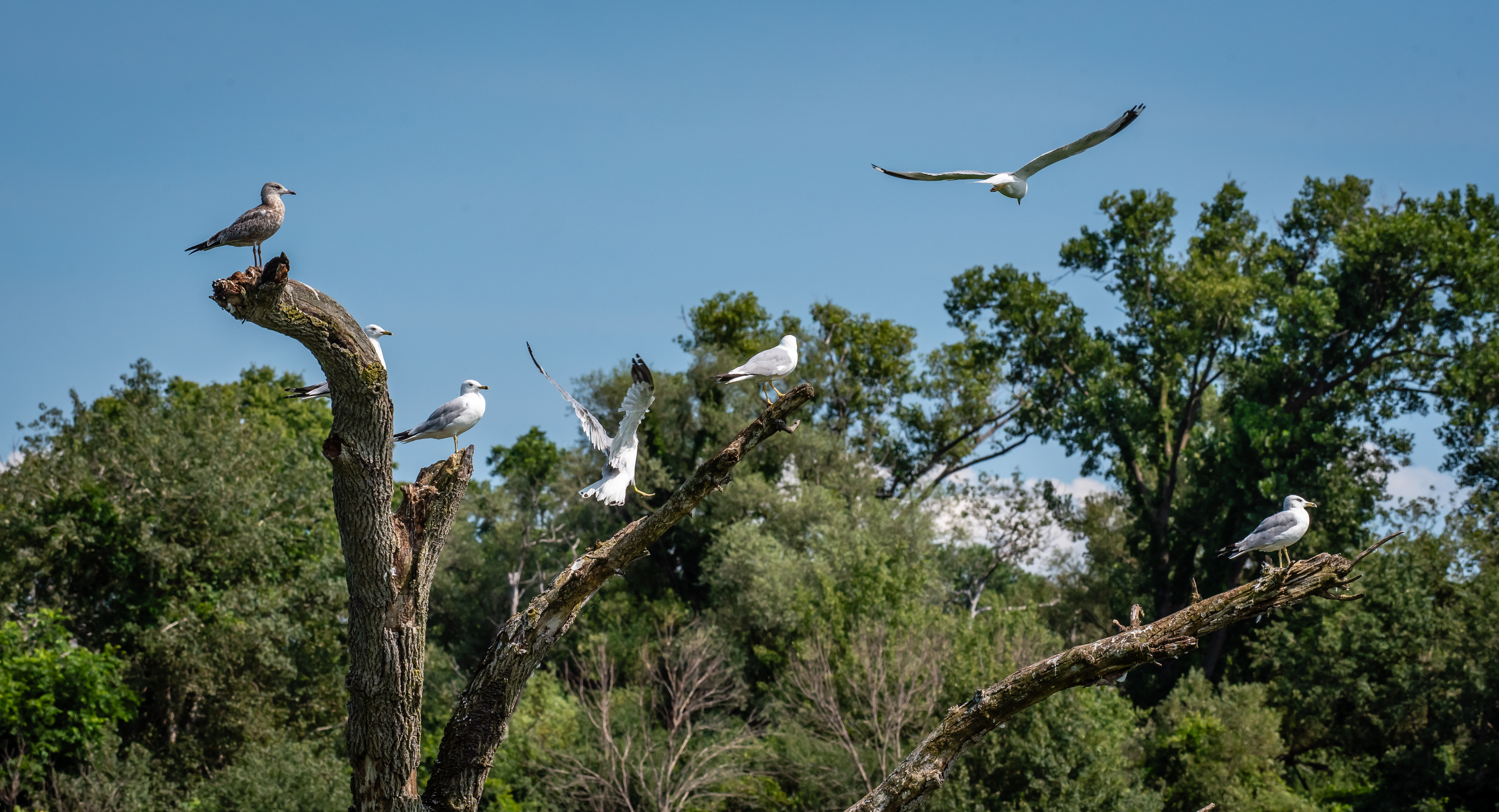
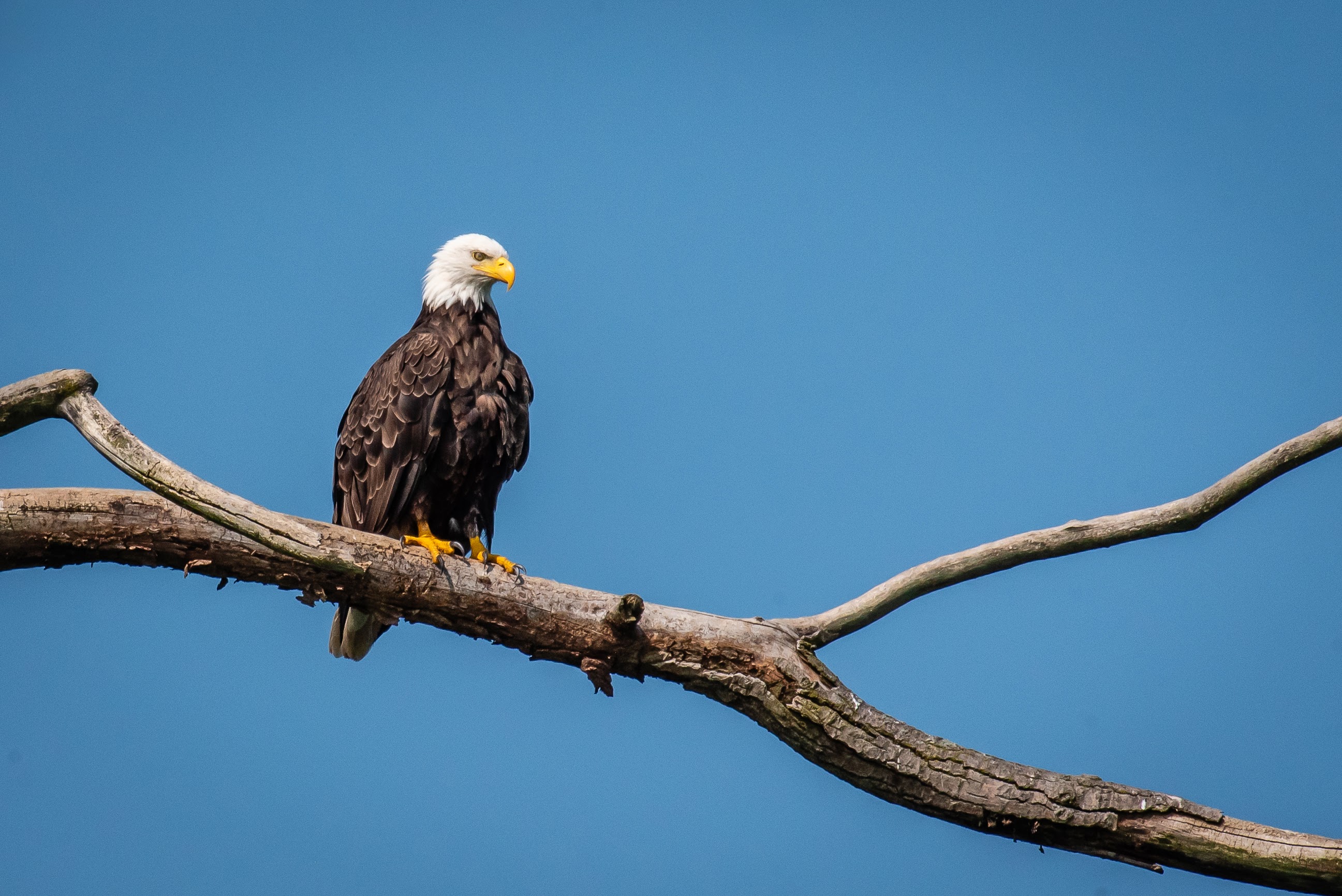
We got lucky along the drive and had a bald eagle to watch. As we first pulled up, it was circling over one of the ponds before it then perched on a branch of a large dead tree. We stayed put at this spot for nearly 30 minutes. With my long telephoto lens, I was able to get some good shots of the eagle. I kept hoping it would spot a fish in the water below and I might get an opportunity to get some real action shots, but it seemed content to just stay put and preen itself occasionally.
 |
| Tern Soars Overhead |
 |
| Bald Eagle |
 |
| Looking Ahead |
 |
| Look This Way |
 |
| Calling All Eagles |
 |
| Look That Way |
There is one section of the drive that is less than 100 feet from the NYS Thruway so it isn’t all that scenic or quiet. There is another observation platform and a huge bald eagle statue both of which are highly visible from the expressway as well. I suppose it makes for pretty decent advertising. It is free to drive thru the refuge so it is a great bargain and with any luck you may spot something impressive.
 |
| Sandhill Crane |
 |
| Observation Platform |
 |
| View of Another Pond |
 |
| Huge Eagle |
 |
| Great Blue Heron |
We took it easy for a few days getting in a walk at Seneca Lake SP or going for bike rides along the Seneca Cayuga Canal. We also managed to meet up with some friends we hadn’t seen in 5 years. We had so much to catch up on and reminisce about the good old days at Kodak.
We head out one Sunday for another bike ride. This time it was to the Howland Island Wildlife Management Area. This island is just over 3000 acres in area and doesn’t have a great deal of access - I suppose many islands are like that. From what we can tell are about a dozen miles of trails but if the outer perimeter is followed, it should be about 6 miles. There is a gravel road and apparently a bridge that comes in from the west side of the island to a parking lot. Beyond the barrier, the gravel road continues and looks like it might be a nice easy ride.
 |
| View from Parking Area at Howland Island |
I had downloaded a map track onto my Garmin so we would know which way we wanted to go as we got to various turning points. At the quarter mile point we have to option of left or right to follow our loop. We go left and head north to go around in a clockwise direction. We were surprised that the “road” we were taking was actually a grass path. It wasn’t freshly mowed but had been done recently enough so that it wasn’t like biking through a field of weeds.
 |
| Grassy Trail |
The trail had some short hill up and down along the way that made it more of a workout than we may have expected. There are lots of small ponds along the way. They all seemed to be named and had some sort of overflow drainage so they may have been man-made? In any event they provided for nice stopping points to take in the view and see the occasional heron.
 |
| Duck Weed Covered Pond |
 |
| Lost Pond |
At about the 4.5 mile point, we come upon a large bridge over the present day Erie Canal. The bridge is closed to vehicles but can be accessed by foot or bike. Since there was a geocache hidden on the far side of the bridge, we headed across to find it and decided this was a pretty spot to enjoy the PB&J sandwiches we had bought along.
 |
| Approach Old Bridge |
 |
| On the Bridge |
 |
| Canal View |
We only had another 1.5 miles to get back to the car. Some of the interior roads might have been fun to explore but it seemed like the bike ride on mainly grassy trails and all the ups and downs had worn us out more than we expected so we only stopped occasionally to catch our breath and enjoy the numerous ponds. This was a fun ride an there weren’t many other visitors when we were there.
 |
| No Coots to Be Found |
We still had much of the afternoon left so we drove west to the town of Newark. This is another of these classic Erie Canal towns. We had an Adventure Lab to do that would help us tour the area. I guess we could have used our bikes to complete this, but we decided to just walk. We start out at Lock 28B of the present day canal although just a few hundred feet away are the remains of the Lock 59 from the Enlarged Erie Canal built in 1840.
 |
| Present Day Lock #28B |
 |
| Historic Lock #59 |
 |
| View of Erie Canal |
Next we head into downtown Newark and walk along the path next to the canal. There are several pleasure boats docked next to the park. It appears they have the ability to get electricity and water here when they spend the night docked here. It is a pretty walk and there are several murals along the way. We ended up walking a couple miles finishing up our nice afternoon in Newark.
 |
| Along Erie Canal in Newark |
 |
| Another Canal Mural |
 |
| Bridge Over Canal |
On Wednesday nights throughout the summer, there have been concerts near the Finger Lakes Visitors Center in Geneva. We managed to make it there once and really enjoyed the experience. It helped that it was a very pretty evening to be sitting in the park. The group playing that night was Mark Gramling & the Groove Phonix. I think there was only one song I recognized but the band was pretty good and received a very warm reception from the crowd because the frontman for the band was a former city councilman in Geneva.
 |
| Nice Evening for a Concert in Geneva |
 |
| Child Dances to the Music |


No comments:
Post a Comment