Map of this blog's locations click this link to open the map
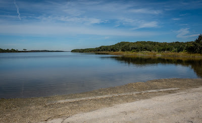
We’ve seen a lot in the St Augustine area but are only halfway through our stop at the Elks Lodge in town. We are about 30 miles from our “home” base of Green Cove Springs. Normally we have our mail service forward our mail from time to time but since we are this close, we decide to make a day trip to pick up our mail and visit somewhere else in the area. The J.P. Hall Bayard Point Conservation Area is a large tract of land that is part of Florida’s many water management districts - in this case the St Johns River WMD. We have visited many of these types of parks and usually enjoy the hiking and biking opportunities provided by them. We had read up on this park and decided that mountain bikes would be the best way to explore here. We did not have any geocaches to look for but it still looked like it would be fun.
 |
| Welcome to Bayard Point |
After getting our mail, we headed to the large parking area. One side of the road has plenty of car parking while the other side has a large lot designated for horse trailers. It didn’t look like we would be running into any horses on the trails and there were only a few cars when we arrived. Like many of these land parcels run by the water management district, there are lots of roads behind a locked gate that has a pedestrian entrance. We set off down the road not knowing what to expect. The main perimeter trail is just over a 10 mile loop. We knew we could handle that distance but it would greatly depend upon the trail conditions.
 |
| Good Trail Conditions to Start |
The initial portion of the White Trail was fine. It was a road that vehicles could travel on and when we hit wet sections, we could generally get around or through them without problems. There were several secondary gates that we needed to lift the bikes over. On the south side of the park was a section where hunting is permitted. Fortunately they had a sign up with a list of all the days hunting was allowed and we were in the clear today.
 |
| Heading into the Southern Part |
 |
| Praying Mantis |
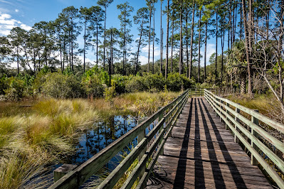
As our loop started back north along the eastern part of the park, we ran into a muddy section of a lesser traveled trail. After a few hundred feet, we found ourselves needing to walk our bikes. But after a quarter mile, we were in a full fledged quagmire. As far as we could see up the trail, it looked the same so we gave up on the original plan and headed down a good gravel road to pick up another section of the trail that would get us past the muddy sections and onto better trails.
 |
| Big Mud Puddle |
We still managed to find our way to a two story wooden observation tower. We stopped for a break and to take in the views from up high. We slowly worked our way back to the car. The ride ended up being just over 8 miles by cutting out some of the muddy sections.
 |
| Observation Tower |
 |
| View from Above |
The Elks Lodge is immediately next to the St Augustine Amphitheater and on Saturday mornings there is a large farmers market that takes place in the parking area of the concert venue. It brings a very large crowd. So large that many people park in the lodge’s parking lot and walk over to the market. We took advantage of the proximity of the market and wandered over to see what we could find. While there were a fair number of produce stands, this market did have a lot of booths selling arts and crafts items or various foods, spices or drinks. We did come back home with a big bag full of vegetables.
 |
| At the Farmers Market |
About 20 miles south of camp along A1A is Washington Oaks Gardens State Park. The former winter residence of a wealthy businessman, the property was donated to the state and became a park in 1964. The old home is open to the public and was in the process of having all the Christmas decorations put up.
 |
| Entrance to State Park |
 |
| Former Residence |
 |
| Inside |
One side of the property is right along the Matanzas River and as we were heading towards the gardens, several boats went cruising by.
 |
| Sailboat Motors By |
We spent a great deal of time wandering around the formal gardens. For early December, I was impressed with just how many of the plants were still in bloom. Many of the flowers were ones we cannot recall seeing in other gardens.
 |
| Yellow Rose |
 |
| Crimson Passion Flower |
One section of the gardens had dozens of butterflies flitting about. With a little patience, I was able to get some pictures. A gazebo near a pond with a small fountain was a rather tranquil setting.
 |
| Underside of Butterfly |
 |
| Gazebo By Pond |
It’s not too uncommon in this part of the south to have large live oak trees draped in Spanish moss and ferns growing along the larger branches. But there was one such tree that had a rather unexpected addition amongst the ferns - a prickly pear cactus was growing in the crotch of the tree well above our heads. We spent close to an hour walking through the gardens. The park does have some other trails on the north side of the park but we decided to skip the 2 mile walk since we had a few other stops planned for our outing today.
 |
| Prickly Pear Cactus Grows in Live Oak Tree |
The park extends to the Atlantic side of A1A so we drive over to the beach area here. It was a rather overcast and windy day, so not a lot was going on at the beach. But there were a fair number of shore birds scurrying along the edge of the sand and the surf. They were quite fascinating to watch, especially the small sanderlings with very short legs. As a wave would come in, its legs became a blur as it tried to get away from the water, but as soon as the wave retreated, the bird would follow it back out picking in the sand for things to eat.
 |
| Rough Surf |
 |
| Sanderling on the Move |
 |
| Slightly Larger Willet |
About a quarter mile north of the parking area along the sandy beach is a large outcropping of coquina rock formations. This is a rather interesting type of rock that appears in many old buildings around Florida. It is a type of limestone that has many shells as part of the aggregate. A small group of brown pelicans were flying in formation, low over the water level in search of some fish. Occasionally we would see one pull out of the line and fly up 20 feet before diving back into the water. They were far enough out that it was never clear how successful they were.
 |
| Outcropping of Coquina |
 |
| Closer View |
 |
| Pelicans Form a Line |
Next we drive over to Princess Place Preserve, not far away. This is a large preserve that is county owned and operated. It is just across the creek from the Faver-Dykes State Park we hiked in a couple days ago. We pulled into the parking area and were having our lunch before walking the grounds when another car parked right next to us. At first we didn’t pay much attention to the couple until we saw the guy putting on the Christmas grinch costume. That isn’t something we see everyday. I can only assume there was some sort of event or party he was attending.
 |
| Covered Bridge at Entrance to Princess Place |
 |
| The Grinch Looks Dejected |
We wandered around the grounds admiring the main building. It is an Adirondack style hunting lodge built in the late 1880’s. Given how big this place is, I’m not sure lodge is the correct term. We knew there was supposed to be a tour inside the house in a half hour so we stayed close by to make sure we didn’t miss it.
 |
| Hunting Lodge? |
 |
| Rustic Porch Posts |
One of the county employees showed up to lead the tour. The house has a main room with an extremely tall ceiling and is quite impressive. The guide explained how Hurricane Irma in 2017 flooded this area and there was over a foot of water in the main building. From the looks of things, they have done an excellent job of restoring it.
 |
| Getting the Tour |
 |
| Xmas Tree and Fireplace |
The exterior walls of the building are large blocks of coquina. It was fascinating to see how intricate the shell pattern is in this building. There is a barn with an old horse drawn carriage and even a swimming pool that is still able to hold water.
 |
| Amazing Coquina Blocks |
 |
| View from the Deck |
 |
| Old Carriage |
 |
| Functioning Swimming Pool |
There are lots of trails within this park and we had a few geocaches to look for so we drove along the Loop Road and did a short hike on the Artesian Trail. This is a rather impressive property.
 |
| Wide Grassy Trail |
 |
| Water View from Trail |
 |
| Butterfly Tile Mosaic |
As I mentioned, the Elks Lodge is right next to the amphitheater and while there were a fair number of cars parked there for the Saturday morning farmers market, we had been warned that when there is a concert at the amphitheater, the parking lot at the lodge fills up and we should plan to be back before the crowds arrive and traffic is impossible. The venue holds about 5000 people but there isn’t nearly adequate parking on the amphitheater grounds so the cars spill out into the surrounding area.
Well, that evening was a Bret Michaels (former lead of the band Poison) concert. We planned to get back by 4 PM, figuring that would get us back in plenty of time. But it turned out that people were already starting to arrive and park at the Elks Lodge. We were allowed in and parked by our rig like normal. Over the course of the next few hours, things got rather busy at the lodge. There were quite a few lodge members helping to park all the cars and by the time the concert started, we were surrounded by cars. Many of the people that arrived early were partying at their vehicles and it was a rather boisterous crowd. I walked around the lodge property while the concert was underway and counted at least 180 vehicles. They charged $20 for parking so I suspect that amphitheater parking might be one of more lucrative side hustles for this Elks Lodge.
 |
| Some of the Cars Parked for Concert |
The next day was a rainy one, but a day later, the weather improved and we headed over to Anastasia State Park. We would have no real excuse to miss this place since it is right next to the Elks Lodge. For all we knew, we could have simply walked in but we did the conventional approach and drove thru the main entrance. On the road heading into the park is a pullout with parking for a few cars. There is an old coquina quarry located down the short trail but it turned out to be a bit underwhelming. We did have a virtual geocache to log there so it was worth it for us to stop.
 |
| Path at Old Coquina Quarry |
Inside the park, we stop at a trailhead for the Ancient Dunes Trail. This loop trail in the woods is about 3/4 mile long. Another trail from the parking lot took us a short distance to get a view of Salt Run which appears to be a small bay between Anastasia Island and the beach area within the state park. We get a good view of the dunes that run along the beach.
 |
| Ancient Dunes Trail |
 |
| Dunes Block Ocean View |
The weather was acceptable but this was by no means a beach day. We saw a few other people walking along the beach but not much was happening today. Given the size of the main parking lot, it appears that this place likely gets quite crowded on hot, sunny days.
 |
| Concession Stand at Beach |
 |
| Looking South |
 |
| Decent Wave Action |
The beach seems to be the main feature of this park. From the main parking lot, the park’s beach extends about 3.5 miles up to the outlet from the river in downtown St Augustine to the ocean.
 |
| Another Willet |
 |
| Lighthouse Beyond the Dunes |
 |
| Shells Exposed by Waves |
We weren’t sure how much of a beach walk we were willing to do. We know from experience that the firmness of the sand has a lot to do with how enjoyable this type of walk is. We saw a large ship on the horizon and wondered if it might be heading into the harbor area in St Augustine. At first my goal was to get get closer but it seemed like the ship never got any closer to us. For all I could tell, it may have been sitting 10 miles away. We made it about 2 miles up the beach before turning around. On the way back we could easily see the lighthouse that we kept meaning to visit but never got around to fitting it in our schedule.
 |
| How Far is that Ship? |
 |
| Dunes Along the Beach |
On our way back down the beach, we noticed another entrance point through the dunes so we headed that way to check it out. There is a 750 foot long boardwalk along the backside of the dunes which leads to the large parking lot. We were lucky enough to see one of the tortoises sitting just outside its burrow. We enjoyed the visit to Anastasia State Park. It likely would have been better on a hot day but it was nice to have the place nearly to ourselves.
 |
| Tortoise |
The next day, we head north along A1A about 12 miles from camp. Our goal was the Guana Tolomato Matanzas National Estuarine Research Reserve. I sure hope the locals have a good abbreviation or nickname for this place because that name is a mouthful! This place had been another recommendation by the bartender at the lodge. When we looked into the area, we saw there was nearly 10 miles of trails and double that if you include the wildlife management area connected to the north of the reserve. From what we could tell, most of the trails were multi-use and suitable for mountain biking so we bring the bikes along for the outing. The property is situated between the Atlantic Ocean, the Guana River and the Tolomato River, so we were expecting to possibly run into wet conditions.
 |
| View of Guana River Above the Dam |
The parking area is basically a dam in the Guana River with boat ramps to both the north and south side of the dam. Many people were here fishing from the shores when we arrived. The route we picked out on AllTrails was listed as 9 miles and would use a combination of trails that the reserve has color coded for easier navigation. Our route would include the Orange, Blue, Purple and Red Trails. We checked out the bulletin board by the restrooms with the trail conditions. It was last updated 4 days ago but two of our planned trails listed the conditions as “flooded and deep mud” while the other two were “dry with some deep puddles”. It had been fairly dry since the conditions were updated so it wasn’t clear if things had improved enough to make this ride even possible but it started out fine on the wide gravel service road.
 |
| Nice Shaded Trail |
It was definitely a very pretty area. There was a long boardwalk along one section that prevented us from needing to trudge through a very flooded area. At one trail intersection, we had to bike across a trail we would definitely consider flooded but it wasn’t too muddy of a crossing so we managed to make it without falling!
 |
| Boardwalk Keeps Us Dry |
 |
| NOT Heading Down that Trail! |
We made it around the northern section of the intended loop with too much trouble. When we hit a side trail that headed over to the Tolomato River, it appeared to be in good shape so we took the detour to check it out. There was actually a nice beach like area and a few boaters were making their way along the river.
 |
| Decent Beach Along River |
 |
| Tree Sprawled Over Beach |
As we worked our way south along the western side of the Purple Trail, we ran into some of those large mud puddles. Some had enough room along the edges to get past without getting too wet, others required some faith they wouldn’t be too deep and just go for it. We found another small beach area with a picnic table which worked out well for lunch before we continued on south.
 |
| Chris Makes Waves |
 |
| Lunch View |

At one point along the western side our expected trail was closed. It appears that this portion is constantly flooded and muddy and they have simply barricaded it off. There is a cutoff trail that gets us over to the much drier Red Trail. Since we had hoped to make it to the southern part of the reserve, we head south about 3/4 mile to see the views from where the two rivers join. The views weren’t any better down at the tip than they had been elsewhere but at least the trail was much nicer since we didn’t have to negotiate mud puddles. It was just over 3 miles from the tip back to the car, but they were definitely the easiest biking section of the whole ride. We did see an armadillo just off the trail in the open woods. It was fascinating to watch because it seldom lifted its head out of the leaf debris along the forest floor. Its head was like a miniature plow digging up the top layer of ground in search of grubs. This was definitely one of our more enjoyable outings on our mountain bikes.
 |
| Armadillo Plows Through Leaves |
 |
| Visitor Center |
There is a large visitor center on the property and we had finished our bike ride in time to check it out before they closed. There were lots of displays explaining facts about estuaries and the importance these areas have on the environment. They also have lots of live animals in the various rooms.
 |
| Sea Creature Overhead |
 |
| Mostly Hidden in Burrow |
 |
| Coiled Up |
One of the staff was in the middle of checking out some of the diamondback terrapins that live in a rather large tank near the entrance of the center. She had removed them from the tank and had them in some big plastic bins. There was also a tank of some baby gators that were really neat to see up close. This was definitely a fun stop during our stay in the area.
 |
| Diamondback Terrapin Stuck in Bin |
 |
| Gators Floating Beneath the Surface |
 |
| Crab on the Move |
 |
| Terrapin Back in the Water |
Our twelve nights in St Augustine were quickly coming to an end. On our last day, we ventured out a bit further and picked some destinations around Jacksonville. It’s only about 40 miles to the north so it isn’t too long of a drive. We started out by heading to the Arboretum and Gardens. Visiting on a Wednesday morning definitely had us avoiding the crowds. There were a fair number of workers setting up all sorts of lights for what they call Dazzling Nights.
 |
| Lights Installed |
 |
| A Tunnel of Lights |
 |
| Happy Holidays |
There are several miles of trails to explore. Some of them have ropes across the entrances but we decide these are in place for when the park is open for the night display and they want the people to stay only on paths that have lighting. Given it is a bright sunny morning, we can explore some of the more remote areas. The Sand Ridge Trail on the north side of the park is about a one loop and was rather pleasant. Some of the trails in the ravine and near Jones Creek on the south side were more our style of hiking in wooded areas. We managed to hike over 3 miles within the gardens this morning.
 |
| Pond View |
 |
| Follow the Green Path |
 |
| Along Sand Ridge Trail |
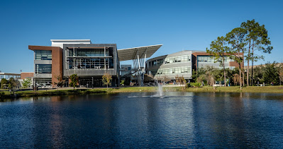
Our next destination was some shopping at REI - we seem to always find something we “need” at this store. Then off to Chuy’s for lunch which is one of our favorites but not found all that frequently. With full stomachs, we head over to the campus at the University of North Florida. There is an Adventure Lab that tours us around the campus. It isn’t a very big place but still nice to explore. It is a rather new campus. Having visited the University of North Carolina in Chapel Hill just a month ago, the two campuses are quite different. Of course UNC had about a 190 year head start on UNF.
 |
| UNF Fountain |
 |
| Unique Stone Mosaic |
 |
| Modern Campus Buildings |
Instead of taking the interstate back home, we headed east to the coast and planned on coming back along A1A. In the city of Jacksonville Beach, we had a highly favorited geocache to look for. There is the Beaches Museum which has several old buildings from the area on its grounds. Our timing was bad since it was closed, but we could walk around the grounds and find the cache that brought us here. One of the buildings houses an old steam locomotive.
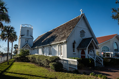 |
| Old Church |
 |
| Steam Locomotive |
Well that brings us to the end of our stay in St Augustine. It was definitely one of our favorite stops of the year. Given how convenient the Elks Lodge is here and the fact it has full hookup sites and takes reservations, I could see us making this stop again. Next stop - the Space Coast and Titusville Florida.


No comments:
Post a Comment