Map of this blog's locations click this link to open the map
Continuing with our stay at Collier Seminole State Park near Naples Florida, we had stopped at the Big Cypress National Preserve visitor center earlier and had gotten lots of biking and hiking recommendations. I think the park rangers are happy when somebody comes in and says “we’re here for 10 nights, what should we see and do?”. I suspect most people are simply driving between Miami and Naples and have a hour or two to spare. One of the recommended spots was actually just outside of Big Cypress in the adjacent Fakahatchee Strand Preserve State Park. When a national park ranger suggests a trail outside of their “territory”, we suspect it might be a good one.
From the sounds of the trails in this park, we came to the conclusion that mountain bikes would be the best choice for exploring although we brought along our hiking boots in case we discovered we were wrong. Our goal was to drive into the parking lot on Jane’s Memorial Scenic Drive. From the research we did in advance, we knew we could get part way into the park via car but it wasn’t clear at what point the road would be gated and we would be forced to resort to bikes. The scenic drive starts off of Florida State Route 29 and is actually paved for about the first mile to the park entrance and office. Nobody was around when we arrived but they have an iron ranger to pay your fee to enter the state park - or use your annual state park pass as we did. They do have restrooms here which might come in handy since there are no services for the rest of the excursion. There is a tall fire tower near the office but it isn’t open to the public.
 |
| Entering Fakahatchee Preserve SP |
 |
| Tall Fire Tower |
We continue the drive along the scenic road to the west. It’s a fairly wide gravel road that starts out in reasonably good shape. We didn’t see any other people or cars for quite some time, but we saw plenty of alligators laying in the sunshine along the edge of the road. About 4.5 miles from the office, we get to our first destination - West Main Tram. We later discovered why these roads or trails are called trams. Back in the 1940’s thru 1960’s, the forest was logged and actual rail lines were put in place to haul the lumber out. Once one area was completed, the tracks were pulled up and moved to a different section and set up there. West Main Tram is behind a locked gate but easy enough to get around with our bikes and we continue west.
 |
| Gator Seen While Driving to Trailhead |
 |
| Starting the Journey into the Unknown |
This tram goes thru a very dense forest with lots of low brush growing along either side of the “road”. We start to see gators all along the side of the road - usually just one at a time but occasionally there are two next to each other. Each time I spotted one, I would ring the bell I have on my bike to warn Chris we are approaching a gator. Then I would decide what my strategy should be. Most of the time they were on one side of the tram or the other and I would simply zip by going as far to the opposite side as I could. Chris maintained a reasonable distance so she could gauge how the gator reacted to my passing by. More often than not, they didn’t move whatsoever. But a few times they would bolt into the shallow waters that were usually on either side of the trail.
 |
| A Big One Along the Trail |
 |
| Something Less Dangerous |
Not too far into our ride, we noticed a vehicle approaching from the opposite direction. I assumed it was going to be some sort of state park truck, but it looked to be just an unofficial SUV. There wasn’t a lot of room to get off the road to allow it to pass, and by now we knew there might be be a gator right at our feet, but we safely got over and they passed by with a wave. A bit further into the ride, we spotted a couple of cabins just off the road. They didn’t look to be very fancy but it appears someone lives in them at least at times and this must have been where the SUV was coming from.
 |
| A Home in the Swamp |
After about 30 minutes, we had made it 1.7 miles in from the gate. This was definitely not record breaking speeds, but a pace that was prudent to be able to spot the gators before we got unexpectedly too close. It was at this point, that there was a big gator that was more or less covering 75% of the road. We stopped and evaluated our options and came to the realization that this one didn’t appear to want to move out of our way regardless of how close we got or how much noise we made. Since there wasn’t anything in particular down this trail, we decided to use this gator as our excuse to cut this part of our ride short and turn back. We got the opportunity to see most of the same gators a second time on our return trip but none of them gave us any problems.
We wanted to try the next trail at the East Main Tram trailhead - about 2 miles down the scenic drive. We debated just biking the dirt road since it was definitely rideable, but we opted to put the bikes on the rack and drive to there. We saw plenty more gators along the road and they seemed to be bigger than the ones we had seen on our bike ride, but being in the car makes all the difference in how safe we felt going past them. There was a larger parking area at this trailhead and this is also where cars are stopped from going further by gates across 2 different trails. There were a couple of other cars here so at least we weren’t the only crazy people out here today. We have our lunch then head up the more major of the two gated trails. This road is pretty much just a continuation of the scenic drive except that vehicles are prevented from driving it so it is actually in pretty decent shape and it is much wider than the West Main Tram.
 |
| Yet Another Gator but Off the Road |
Of course that didn’t mean there were any fewer gators along the way but none that posed a problem in getting by. Since it was a wider road and better visibility, we were making better time. This trail actually had a geocache hidden on it and that was going to be our goal to bike the 3.5 miles from the gate to the cache and back. Unfortunately 20 minutes into the ride, at the 2.1 mile mark on the trail was a monster gator. Probably about 8 to 9 feet long and it was stretched across both tracks of the road. We attempted to scare it off but after several minutes of making noises and approaching it, the only response we got was more a look of annoyance than anything else. We still had another 1.3 miles to get to the geocache, but this guy proved to be our breaking point. I didn’t want to explain to people I meet in the future how I lost my leg going for just one more geocache!
 |
| Our Nemesis Blocks the Full Road |
Back at the car and the trailhead, there was a large trail map and information sign. It mentioned a cabin that was along the second, less substantial trail. The Fakahatchee Hilton - as it was called - was 2 miles down this tram. It sounded interesting and since we had been thwarted on the first two bike rides today, we had energy to try this one. This one turned out to be a much narrower and more technical bike ride. I doubt anything bigger than a small quad could make it back to the cabin. Since the trail was only 4 feet wide, it meant there wasn’t much room to navigate past any gators we spotted along the way. At one point, I was steering the bike thru some tree roots and mud only to realize the line I was taking to get past the mud, had me on a collision course with a gator. I was able to quickly adjust my track and avoid disaster. A quick call back to Chris gave her the heads up she needed.
We made it back to the cabin and were reasonably impressed. The sign at the door did declare it the Fakahatchee Hilton established 1957. It appears that the place is still used on occasion. There was a guy walking around but he was just a visitor like us. We were surprised to see a fire hydrant out front of the cabin not far from the outhouse. But upon talking with the other guy, he was a local and knew of the owners of this cabin. One of them was a retired firefighter and the hydrant was placed on homage of his past work. There were quite a few large alligators just past the cabin and we decided to simply turn around and hope to get back to the car in one piece.
 |
| The Fakahatchee Hilton |
 |
| Outhouse and Fire Hydrant at the Hilton |
 |
| More Gators Out Back |
As we drove back out of the parking area on Jane’s Scenic Drive, Chris spotted something up in a tree over the road. I stopped and confirmed there was a barred owl looking down at us - pretty cool. This was a very exhilarating bike ride even if we only managed a total of just under 12 miles of riding. It’s hard to know for sure how many gators we saw during our ride but it would conservatively be on the order of 40. And the more amazing fact is most of those were seen from less than 10 feet away! There was another geocache hidden closer to the park office so we stopped here on the way out just so we can say we found one hidden in this park.
 |
| Barred Owl Intently Watches Me |
 |
| Another View of Fire Tower |
On the drive back to camp, we stopped at the Big Cypress Bend Boardwalk which is technically part of Fakahatchee. Besides restrooms and a large deck overlooking the swamp, there is a half mile long boardwalk that is quite pleasant to walk along. We saw tons of birds but surprisingly no more alligators.
 |
| At Big Cypress Bend Boardwalk |
 |
| Looking for Dinner |
 |
| View of Boardwalk |
I did get a chuckle out of the warning sign along the boardwalk explaining how to stay safe in alligator country. Had we kept at least 30 feet away during our bike ride in the northern portion of the park we likely would have been limited to less than a half mile ride.
 |
| Reflections |
 |
| Gator Advice |
The following day, we head north for another bike ride. This one was also recommended by the ranger at Big Cypress National Preserve and is on the northwest corner of the preserve called Bear Island. When we investigated the details of this area of the preserve, we got conflicting information as to what sections of the trails were passable and which weren’t. One option was to come in thru the preserve from the south but this would require driving on a rough dirt road for 20 miles each way. There is an entrance off of State Route 29 just north of Interstate 75 which sounded much easier. The plan was to start our bike ride and see how far we could get before running into too much mud and water. We were hoping to do the bike ride as some sort of loop but if conditions warranted it, we could simply back track to the car. The parking area is just beyond a very tall chain link fence and gate. It was closed but not locked so we open it, drive thru and then close it again. Given we are entering something called Bear Island, we can only assume we are now fenced in with the bears.
 |
| Entrance Gate at Bear Island |
This trail is actually a very nice, wide gravel road that was ideal for biking called Bear Island Grade Trail. We see several gators along the road but they are not nearly as prolific as what we saw yesterday - either that or we have gotten immune to the sight of them. At one point I saw something well ahead on the trail that definitely wasn’t a gator but it wasn’t until I got a bit closer that I realized it was a wild turkey. Hopefully this guy knows how to avoid gators too.
 |
| This One Was Awake |
 |
| Wild Turkey |
After heading east for about 3.5 miles, we hit an intersection. A left takes us onto Hard Rock Trail and to the northern end of the preserve. Our original plan was to cut over the Windmill Trail but either it was very poorly marked and maintained or we simply missed the left hand turn as we were enjoying our ride. Although this mistake did get us to a very nice primitive campground named Gator Head. There was a small pond and even vault toilets. The nine sites were quite nice with picnic tables and bear boxes for your food. The place was empty as we looped around the pond.
 |
| More Good Road at Bear Island |
 |
| Pond at Gator Head Campground |
We continued south and we were making good time and really enjoying this bike ride. We were no longer seeing alligators and so far no bears were sighted either. It was clear that the road past the campground was less traveled but so far so good. The. We hit about the 9.5 mile mark. That was when we went from perfectly dry roads to mud puddles and standing water on the road.
 |
| A Road Less Traveled but Good |
 |
| Hitting Some Wet Sections but Passable |
The first half dozen or so were manageable. Even though we could not tell how deep the water was or whether the road surface underneath was firm rock just covered with water or thick mud, we were able to skirt along the side of the road and walk our bikes slowly around each obstacle. The only problem was they seemed to be getting wider and longer to the point that we were unable to get past them with dry feet.
 |
| Much Tougher to Keep Feet Dry |
Surprisingly, by just foregoing dry feet and walking the bikes thru the water and muck, we made better time. The feet weren’t happy but we were moving forward. The issue was we weren’t sure how bad it might get up ahead to know if it might be better to simply turn around. We were already over 11 miles into the ride so we were reluctant to turn back.
 |
| Looks Like We're Wading Thru This One! |
Then in between puddles I noticed Chris’ rear tire was almost completely flat. I was prepared with a spare tube, patch kit and a very small frame pump, so I sat in the hot sun to make the repair and get on our way. I’ve fixed many hundreds if not thousands of flats over the years since I was a kid so a flat tire doesn’t phase me but after putting on the spare tube and starting to inflate it, I realized the tube wasn’t holding air - not even a little. (I later discovered this spare tube I’ve had along for many miles had two small slits in it and was not going to hold air.) I did have a patch kit but I knew the leak was rather slow and finding the hole to patch would be a pain so I reinstalled the original tube, pumped up the tire and put my gear away. The hope was we could go a mile or so before I needed to add air again and we could limp the unknown distance back to the car. One surprising fact was just how fast Chris can ride her bike when she is trying to outrun her rear tire going flat!
We got lucky in that there weren’t that many more ponds to walk the bikes thru and better yet, we hit another camping area around the 12.5 mile mark. Bear Island Campground was even larger so we parked at an empty site, stripped off the wet cycling shoes and socks to dry in the sun while we had our lunch. Not that things dried out much in that short of time but simply wringing the water from the socks made all the difference in foot comfort.
 |
| A Nice Lunch Stop |
Chris’ rear tire got reinflated and we were off. The best part about stumbling onto a functioning campground was the road to it was nice and dry and we were able to make good time again. Once we were back onto the main road to the car, we started to see our alligator friends again. All I could keep thinking about was how fortunate we were that there were no gators in the wet areas where we had to walk bikes and deal with the flat tire. I said fixing a tire doesn’t phase me, but having a gator watching me do it might be a little bit above my limit! As we got near the car, we saw a truck approaching. It was the park ranger and we stopped to talk with him. We told him we only saw a dozen or so gators but were unsure how many had seen us. This was a fun but challenging 21 mile ride.
 |
| Small Pond Along Road |
 |
| This One Looks Asleep |
Just down the road from Bear Island is the Florida Panther National Wildlife Refuge. Even though we were tired, there was both an Adventure Lab and a regular geocache here so we stopped to check it out. This was the second time today that we had to enter an enclosure through a gate today. But instead of heading towards bears, we were in search of panthers - or mountain lions as we would normally call them. There are two trails here but we aren’t up for the longer one after our ride. We took the 1/3 mile walk along one of the trail and learned things about these animals but never saw one. Hard to say if one didn’t see us.
 |
| Let's Go Find Some Panthers! |
 |
| Pretty View at Panther Trails |
We took it much easier the following day with a drive from camp to the east. We had several geocaches at stops along US 41. One of the more interesting stops was at the Kirby Storter Roadside Park in Big Cypress National Preserve. There is a rather large parking area with restrooms and picnic tables. The half mile boardwalk starts out in full sun but ends up in a shady cypress swamp.
 |
| Starting Out on the Boardwalk |
 |
| Thatched Roof Observation Deck |
There are lots of birds, flowers and other things to enjoy as we slowly stroll thru the swamp. There was one tour group that came by and we listened in on some of the explanations about plants and wildlife. We were tempted to follow along but decided not to follow on the tour we didn’t pay for.
 |
| Buttonbrush Flowers |
 |
| Very Colorful Airplant |
 |
| Small Pond Along Boardwalk |
At the far end of the boardwalk was a large viewing platform overlooking an open pond area where the trees had yet to overtake. There was a turtle on a log just below us that was either oblivious to us being 4 feet away of was accustomed to human visitors. This was a nice stop and we took advantage of the shaded picnic shelter to have lunch before continuing east.
 |
| Very Pretty Water Hyacinth - but Invasive |
 |
| Turtle Below |
 |
| Banana Lily |
Part of the reason we headed out this was was to drive along something called the Loop Road. This is a 24 mile dirt road that was supposed to be a rather scenic drive thru Big Cypress. The road was in good shape and wide enough for two way traffic but it was very dusty and not all that scenic. Occasionally we would come upon a couple cars pulled over to look at alligators but we have had our fill of those for the time being. The Loop Road comes back out to US 41 and the original plan was to head back to camp, but since that scenic drive didn’t take all that long long and we were less than 4 miles from the Shark Valley Visitor Center at Everglades National Park, we decide to continue east to check out this northern portion of the Everglades. This place is just 25 miles from the outskirts of Miami, so it can get rather busy and fill up the parking lot but we were able to get in and parked.
 |
| Shark Valley Visitor Center |
The visitor center didn’t have a lot of displays but it was busy with two main things - getting tickets for a tram ride or renting bicycles. Turns out there is some observation tower that sounds pretty neat but is 7 miles down a paved trail thru the swamp. This is where the tram ride comes for most visitors. The other option is to ride bikes and had we realized we were going to come here, we may have brought them along. We did a bit of a walk down the paved trail to the Otter Cave Hammock Trail only to find it was closed because of flooding. There were a few gators along the trail and they were definitely attracting a lot of attention from passer byers. We did cut across the Bobcat Boardwalk Trail back near the visitor center but there wasn’t much to see along it. So our first impression of the Everglades wasn’t all that great. We have a reservation to camp inside the National Park in early February of next year so hopefully that section of the park is more interesting.
 |
| Another Gator |
 |
| Heading Down the Trail |
 |
| Swamp Lily |
 |
| Bobcat Boardwalk Trail |
We drive a couple miles further east to get a geocache in another county. It took us to the memorial for Flight 592 which crashed in the Everglades in 1996. From here we head back west to camp, stopping at a few places along the way.
 |
| Flight 592 Memorial |
 |
| Colorful Sign Post |
 |
| Green Heron |
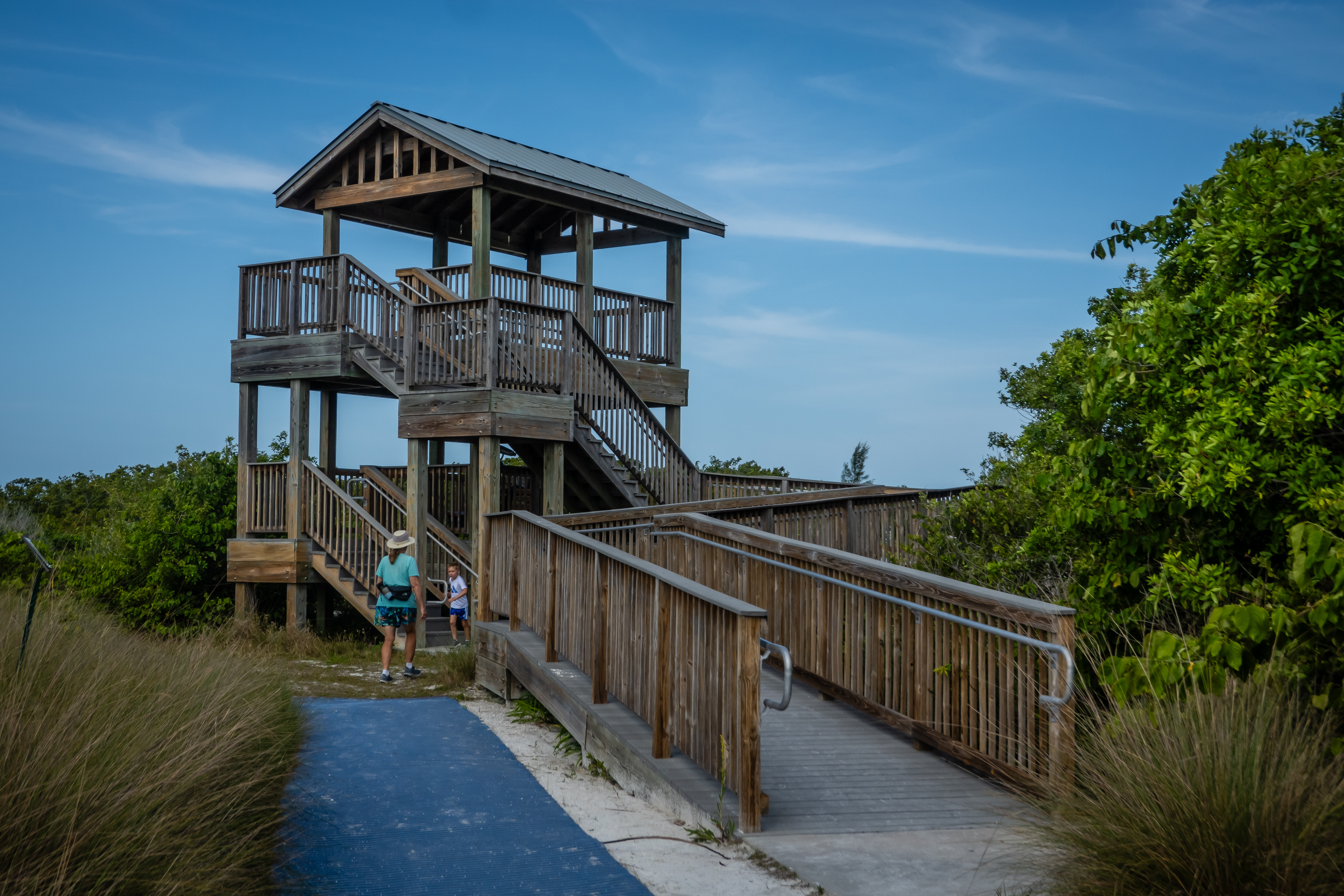
For our last day in the area, we opt to head to Marco Island which is south of Naples and not very far from the campground. This is a very upscale area and extremely densely populated. We plan our first stop to be at the beach - Tigertail Beach specifically. It was definitely a busy day there. We start our walk from the parking lot and spot a two story observation tower. From up top, we got a great view of the area. Many visitors are walking across a shallow bay about 300 feet wide to take a shortcut to the beach. It looked to be about waist deep and since we weren’t dressed for swimming, we opted to simply walk the mile or so around the south end of the bay.
 |
| Observation Tower at Tigertail Beach |
 |
| Beachgoers Cross the Bay |
 |
| High Rise Apartments Down the Beach |
It was a pretty nice beach but we had no plans to just sit and relax so we headed north along the shore. We made it about another mile up the beach before turning around. There was one section where all the small scrub brushes were covered with shells. Most of them didn’t seem to have messages written on them like we have since in other places on our travels.
 |
| Swallow-Tail Kite |
 |
| Shell Tree |
The beach area between the Gulf of Mexico and the inland bay gets fairly narrow at points. There are several boats run up on the sand with people sitting and enjoying the scenery. There was another spot where there were hundreds of royal terns. They were all face the same direction. They are rather striking birds with their black crown, orange bills and gray and with bodies. The kid in me wanted to run thru the middle of the flock but the adult in me limited my action to simply take some pictures. There were also several kite surfers out on this windy day.
 |
| Gulf and Bay Almost Come Together |
 |
| Royal Terns |
 |
| Kite Surfer |
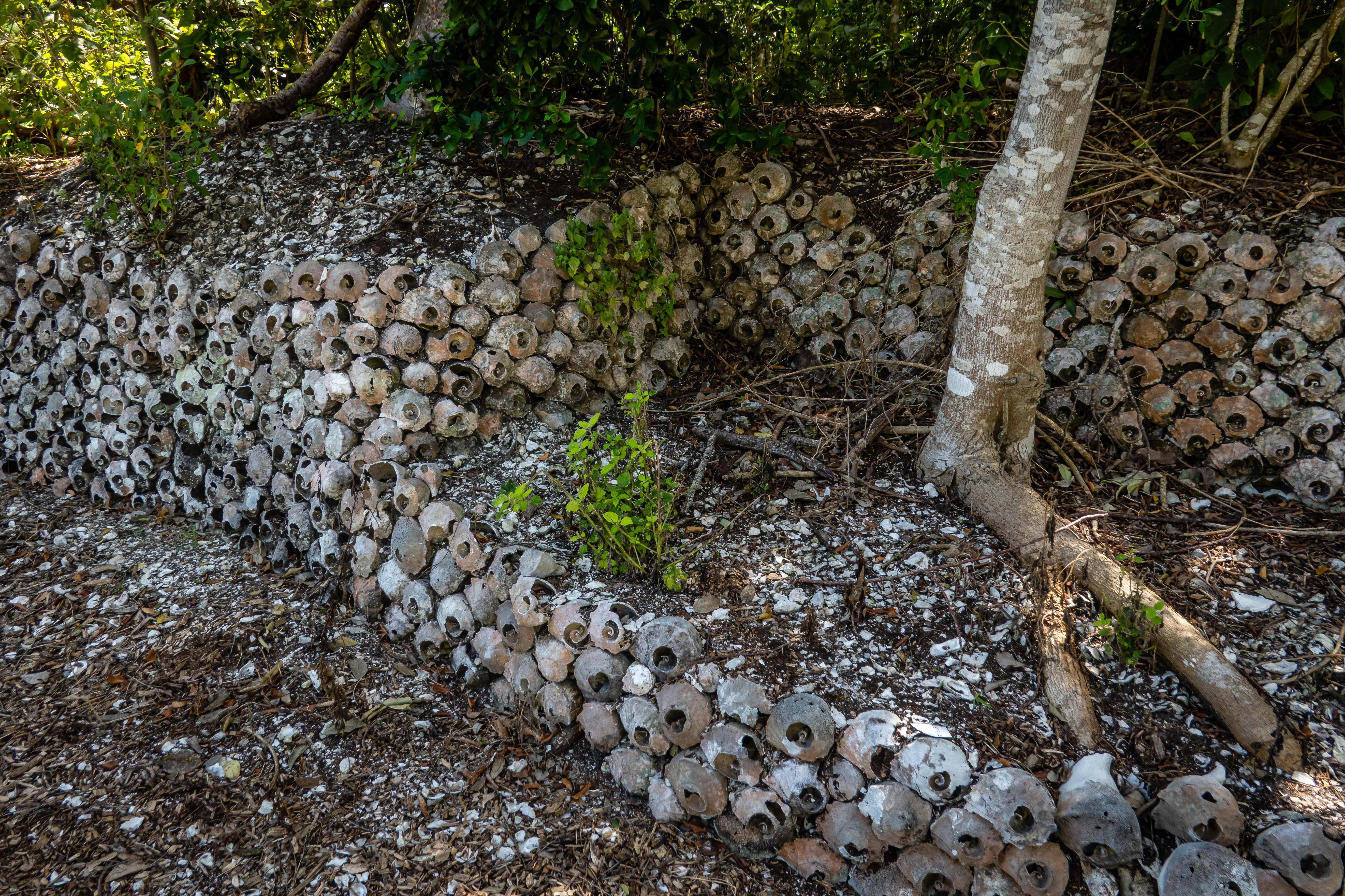
Chris had picked out Lee Be Fish for lunch based on some favorable reviews of the restaurant. The place was pretty small and sort of a dive, but the food was excellent. We had a couple of Adventure Labs to help tour the island and one stop was at a place called Otter Mount Preserve. It is only a 2 acre lot but there is a short walking trail around the property. The most unusual aspect of the property are the terrace walls that are entirely made from whelk shells - many thousands of them.
 |
| Shell Wall |
We enjoyed our visit to Marco Island. The traffic and close living quarters don’t necessarily appeal to us but it was still interesting to see. Our 10 nights at Collier Seminole State Park seemed to go quickly but I felt we got a good sense of the area. From here, we are heading back to our lot at The Great Outdoors for about 3 weeks. The drive from Naples is a bit further than we prefer to travel in a day so we picked another state park to spend one night on our way north. Lake Manatee State Park is east of Bradenton Florida. It wasn’t picked for any real profound reason other than it split our journey roughly in half and it was in a section of Florida we haven’t been to before. Not that one night will allow us time to explore the area, but it will let me get geocaches in two more Florida counties. The state park seemed nice and if we decided to explore this area in earnest, it would be a good home base for a week or so.


No comments:
Post a Comment