Map of this blog's locations click this link to open the map
We have four nights to kill before we head to Vermont for the month of June in the Green Mountains. We plan to split the ~360 miles in half with a stop at the Saugerties New York Elks Lodge. The drive from the lodge in Hazleton Pennsylvania is pretty straightforward with interstates most of the way. We do get the “joy” of paying for part of the journey on the New York State Thruway! It only costs a bit over 7 bucks for the four axles we have and it is easier than trying to travel on non-toll routes. Fortunately we already have the needed transponder to make the trip very easy. It was a nice day for driving until we get off the expressway and head to the lodge and then it started to sprinkle. This lodge doesn’t have RV spots per se but there is a 15 amp outlet on the side of the large pavilion and a nice level gravel lot between it and the horseshoe pits.
We head in and let them know we plan on spending 4 nights here. Since it was still raining a bit, we ended up spending several hours at the bar chatting with the locals. One of the younger members gave us some suggestions as to good hikes in the area. Being in the shadow of the Catskill Mountains in eastern New York, there are actually quite a few options, so it was nice to get some personal insight from her. It ended up getting quite busy at the lodge since it was their horseshoe league night. We asked if our rig was safe where we had parked it and were given a thumbs up. The rain let up and about 10 members came out to pitch their shoes.
The next day we head to the North-South Lake Campground park to hike a section of the Escarpment Trail. This park has a rather large camping area as well as many day use facilities. It does cost us $10 for the day pass. There are other trails that can be accessed outside of the park for free, but it sounded like the best views are from sections of this trail within the park.
 |
| An Early Look at the View Along Escarpment Trail |
The Escarpment Trail is about 24 miles in length total so we are only looking to cover a little over 2 miles of it and then connect in with a few other trails and the park road to turn this hike into a little over a 4 mile loop with just over 500 feet of elevation gain. Being a Wednesday, the park wasn’t very busy. We found the trail head and started out for the hike. It didn’t take us long to understand the naming of this trail. We start up a rocky ascent along the ridge (or escarpment) with a very steep drop off to the east. It was slow going at points simply because of the steepness and need to navigate around the large boulders.
 |
| Chris Surveys the Rocky Path Up |
 |
| Large Rock Along Escarpment |
At about the half mile point we hit Artists Rock. The name is fitting given the large rock juts out over the cliff giving a spectacular view of the Hudson River Valley below. Chris claims she can get a great view from ten feet behind the edge of the cliff!
 |
| Artists Rock and View |
 |
| Hudson River Valley Below |
The trail continues to climb and at about the one mile mark we hit a side trail to Sunset Rock. It wasn’t anywhere near time for sunset but it sounded like a pretty spot and it was less than a half mile of a detour. It also helped that we had a geocache to find there! The first place we come to is Lookout Rock which gives another great view to the east.
 |
| Azalea in Bloom |
 |
| Lookout Rock View |
The trail loops around to the south and then to the west and we arrive at Sunset Rock. As we get closer to the rock, we hear somebody talking very loudly - almost like screaming. We never saw anyone and after listening for a brief while, it almost sounded like someone was praying at the tops of their lungs in an unrecognizable language. We decided the person wasn’t some hiker that had fallen and was calling out for help, so we left them to their prayers. From atop Sunset Rock, we have a great view to the west and the North and South Lakes that give the park its name.
 |
| There Sits Sunset Rock |
 |
| North and South Lakes |
As we backtrack to the Escarpment Trail, I notice a flower hiding in the brush just off the trail. It’s another pink lady’s slipper. It’s a bit strange that we haven’t seen this species of flowers in many years of hiking the woods and just spotted some in the mountains of North Carolina a few weeks ago, and now we find more here in New York.
 |
| Pink Lady's Slipper |
We have some more rock climbing to continue up the trail and in less than a quarter mile, we come to Newman’s Ledge. It was almost noon and we knew that we would be shortly turning off this trail and be in the woods where we wouldn’t get nearly as nice of views. So we find a large boulder to sit on and enjoy lunch while watching the Hudson Valley. We also had a physical cache to find nearby and needed to wait for a few other hikers to depart.
 |
| Rocky Path Continues |
 |
| Newmans Ledge View |
After lunch, we continue up the trail. There are some more steep rocky stretches that slow us down. But we continue to find some pretty flowers to check out while we are resting. At the 2.3 mile mark, we come to a trail crossroads. We have another geocache to find near at Badman’s Cave - not to be confused with Batman’s Cave. We find the cache okay and don’t see a bad man in the cave so it’s sort of a win-win for us.
 |
| Even More Rocks to Climb |
 |
| More Pink Lady's Slipper |
 |
| Dwarf Dogwood |
 |
| Badman's Cave |
It’s at this point that we say goodbye to the Escarpment Trail and head back to the west. The good news by heading away from this trail was we are now in the downhill stretch of the hike after almost 2.5 miles of uphill. It’s a nice walk in the woods and we intersect with a small creek near the 3 mile point. There were a few small waterfalls so we detour a bit to check them out.
 |
| Violets |
 |
| Small Waterfall |
The next trail intersection we come to is well marked but it is also pretty much under water. We want to continue to the south towards the campground but there is another waterfall that we can almost see from the trail sign so we very carefully step from one rock to another in an attempt to get to it without getting wet feet. We were successful and then started down the trail which stays a bit like a creek for several hundred feet.
 |
| A Very Wet Intersection |
 |
| More Waterfalls |
 |
| More Wet Trail |
There is a creek along the trail for some distance but at least now the water seems to be staying in the creek instead of using the trail. All along this hike, we have been noticing these small green spheres just a bit smaller than a ping pong ball. Sometimes we would see them attached to tree branches but more often they were sitting on the ground. They were fairly lightweight so they didn’t seem to be some sort of nut or seed. Turns out they are called oak apples. A type of wasp lays its eggs in the leaf bud of an oak tree and these galls form around the egg and eventually produces a grub which will turn into a wasp. Love how the app Seek and google lens can be used to help answer these questions in the field (assuming we have cell coverage).
 |
| An Oak Apple |
Our maps identified Ashley Falls about 3.4 miles into the hike. It is a short side trail that works down to the base of the falls. It’s worth the effort to hike down and back up even though the legs were starting to feel tired.
 |
| Ashley Falls |
We come out to the main park road after about 3.7 miles of trail hiking. There may have been other trail options to make a loop, but they would have ended up being much longer. We only have about three quarters of a mile back to the car and there are many vehicles on the road so it isn’t too bad of a walk. It did feel nice to have relatively smooth surface to walk on after all the rock, roots and boulders that the trail had offered. We get back to the car and stop at a small fishing deck on the lake to take in the peaceful scene. After 5 minutes, a dark cloud rolls in and it started to rain pretty hard. We hustled back to the car and were thankful that hadn’t happened earlier in our day. This was a very fun hike and trying other parts of the Escarpment Trail during future visits might be warranted.
 |
| Fishing Deck at Lake |
In reviewing some other suggestions the lodge member had given us, we saw we could hike another section of the Escarpment Trail after visiting the one of the more famous waterfalls in the area. So the next day we head back to the same general area but don’t go inside of the park. We had read that the trailhead parking lot at the end of Laurel House Road can fill up fairly early so we get out at a reasonable time and had no issue getting a parking spot. There was a volunteer with a table setup at the trailhead to answer questions. I suspect that half the people that come here are only looking to go see the Kaaterskill Falls so most of the time he is just describing how to get to the viewing point which is only about a quarter mile from the parking lot. We told him we planned check out the falls and then do a loop on the Escarpment Trail and Yellow Horse Trail. As we talked, he realized he was talking with some fairly avid hikers that had trail maps on our phones and on my handheld Garmin GPSr. He told us it was a nice hike and we should enjoy it.
 |
| Small Garter Snake |
The falls are one of the tallest in New York and have two drops associated with it. The upper section drops almost 170 feet and is the easy one to see from a nice viewing platform. The lower section is about 70 feet tall but requires an additional 1/3 mile hike with around 300 feet of elevation change. We choose to check out just the upper section before starting the hike.
 |
| Viewing Platform |
 |
| Kaaterskill Falls |
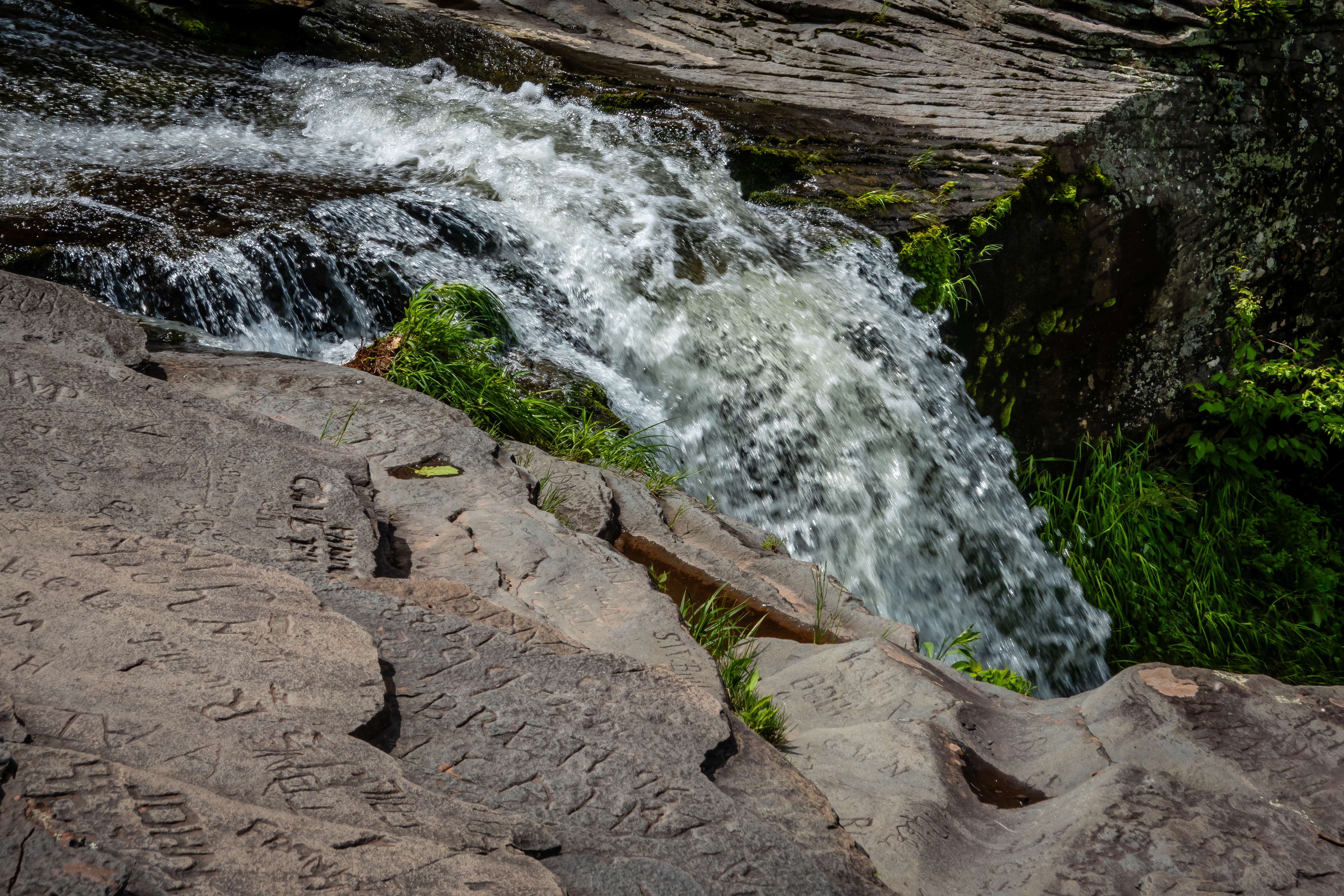
It is also possible to get a bit closer to the top of the upper falls by taking a well established social trail. Chris stayed way back as I explored the rocky edge of the falls. It is pretty impressive to stand atop the falls. If you did this part first, it wouldn’t be clear just how far a drop there would be if you were to slip. The rock surface was pretty dry and even I didn’t get to the point where I could look over the edge. This place had seen many visitors over the years as proven by the number of name and initials and dates carved into the rock face.
 |
| Atop Kaaterskill Falls |
 |
| Water Heading to Falls |
 |
| Carved Graffiti |
 |
| As Close As I Dare Get |
After exploring the falls, we set off on the hiking portion of our day. The trail has a very nice bridge and then come to a major trail intersection with well marked signs to know we are heading the correct way.
 |
| Heading Down the Trail |
 |
| Our Turn onto Escarpment Trail |
The trail goes past the turn to see the lower falls and continues to the south west going downhill slightly before reaching Layman’s Monument. It’s a nice stone memorial to Frank Layman who died fighting a forest fire here back in 1900.
 |
| Striated Rock |
 |
| Layman's Monument |
Once past this monument, the Escarpment Trail follows along the top of the cliff with multiple viewpoints along the way.
 |
| More Escarpment Views |
 |
| Homes Across the Valley |
 |
| Trail Between Rocks |
Inspiration Point is just over half a mile from the monument and does have a nice view plus there supposedly a geocache hidden here. So we decided to make this stop our lunch spot for the hike. We only found the likely hiding spot but no container but it was still a pretty stop.
 |
| Inspiration Point |
 |
| Some Downhill Ski Resort |
 |
| Feeling Inspired Yet? |
Just over 3 miles into our hike along the Escarpment Trail, we intersect with the Yellow Horse Trail. This trail runs roughly parallel to the other trail but up in the woods so the views aren’t as nice. However we were pleasantly surprised so see that while this was called a horse trail, we saw no real indication that horses use it very often. It was in excellent shape and not rutted or muddy like many actual horse trails we have hiked. Coming back on this trail makes the hike about 5.4 miles and roughly 900 feet of elevation gain. When we got back to the parking area, the same volunteer was sitting at the table so we chatted with him some more about another of his favorite hikes in the general area which we will attempt tomorrow.
 |
| More Azaleas |
 |
| Falls Just Off Trail |
Overlook Mountain Trail is west of Saugerties and just a bit north of the town of Woodstock. It’s a popular hike but the trailhead has a decent size parking lot for a couple dozen cars. The lot wasn’t full but it was fairly crowded. The trail is not so much of a trail as it is a gated gravel road. This is an out and back hike listed as 4.6 miles with a few feet shy of 1400 feet elevation gain. The first 1.5 miles is a very consistent 13% grade gaining over one thousand feet of the total elevation and a rather tiring climb. It wasn’t the prettiest of hikes since the woods on either side blocked all the views other than looking up the hill or down the hill.
 |
| Start of Overlook Mountain Trail |
The remaining 3/4 miles to the summit are still steep but only 9% grade. Plus we do have a few geocaches to find along the way which gives us a chance to get a breather. Plus at a little over 2 miles up the trail, just before the summit, are the really interesting ruins of an old hotel. From the description of a geocache hidden here, we knew the ruins were on the way up but we were really expecting to find just a few old rubble walls where you need to use your imagination in order to envision the building that used to stand here. But that wasn’t what we found at all.
 |
| Entrance to the Hotel |
 |
| Three Stories Tall |
Instead we find a three story concrete shell of a very large building - about 180 by 40 feet! It turns out this isn't the original hotel build near the summit. The first was built in 1833 but never really succeeded as a business. A second one was built in 1871 but burned down 4 years later. Another version was built in 1878 which lasted until 1921 until it too burned down. The one that still stands was built from concrete to reduce the risk of another fire loss. But as late as 1939, construction was not completed and a couple years later the land and buildings were sold to the state. It was fascinating to walk around the outside and inside of the structure and see how Mother Nature has started to reforest the inside of the unfinished building.
 |
| Chris Explores the Hotel "Interior" |
Just a few hundred feet from the large building shell is a smaller out building. It’s likely it was built at the same time as the large building given the construction styles being similar.
 |
| Smaller Building Beyond Main Hotel |
 |
| Looking Inside Other Building |
From the old buildings, we still have about half a mile to the summit. There is a fire tower, outhouse and ranger building. Next to the residence was a sign for the overlook which is several hundred feet away. We head there first to check it out and find a nice spot for lunch.
 |
| Ranger/Lookout House |
The rocky ledge offers an excellent view to the south and east with both the Ashoka Reservoir and Hudson River in the distance.
 |
| View from Overlook Mountain |
 |
| Stay Away from the Edge! |
After lunch and enjoying the view, we head back over to see the sixty foot tall fire tower. Even though there isn’t a ranger or lookout on duty, the stairs up the fire tower are open. There is a sign asking no more than 6 people be on the tower at one time. I wait for two guys to come down before heading up myself. As expected, Chris opts to stay below. It is possible to climb all the way to the locked trap door at the bottom of the 8 by 8 foot covered room.
 |
| 60 Foot Fire Tower |
 |
| A View from Underneath |
The views from up here are much better since it is possible to see in all directions. Even though the metal tower looks fairly old, it seems to be rather solid and doesn’t sway in the wind very much.
 |
| View from Fire Tower |
 |
| Hudson River in Distance |
Coming back down this style of fire tower is always the more frightening direction even though they do have a decent amount of fencing block the lower openings of the metal supports. On the way down I notice it is possible to see the corner of the old hotel building sticking out of the woods.
 |
| Coming Down |
 |
| Corner of Hotel |
Hiking back down is much easier. We do stop about a tenth of a mile from the tower to see if we can find the airplane that crashed back in 1983. There is a faint trail heading off the main trail but after we get to an opening with another great view, it wasn’t perfectly clear which way to go and the terrain looked rather steep. Plus the pilot of this plane didn’t survive the crash, so we didn’t feel like we should put a lot of effort into locating the wreckage. Back up to the main trail, we make it to the parking lot about 30 minutes faster than on the ascent.
 |
| There's A Plane Down There |
 |
| Trail Toad |
 |
| Dragonfly |
Just across the street from the trailhead parking is a Tibetan monastery that looked fairly interesting but it wasn’t clear if random people (like us) could just walk around the place. Next door to the monastery is the neat old Church of the Holy Transfiguration. There was a geocache near the road at the church but as our luck would have it there was a county work crew with a backhoe and several dump trucks and multiple workers within 25 feet of the hiding spot so we got a picture of the church and headed out.
 |
| Church of the Holy Transfiguration |
We were only a few miles from the town of Woodstock. Probably best known for the music festival held in August of 1969. I’m pretty sure we must have visited here at least one in all the years we lived on western NY but we definitely don’t remember the place. We park and walk around round town checking out some of the shops. It definitely has a hippie vibe to it in a similar way as does Ithaca New York. We also found an ice cream shop since we figured we deserved a treat after the long hike to Overlook Mountain.
 |
| Doll Artwork |
 |
| Unique Character |
The Saugerties Elks Lodge definitely worked out well as a home base for the Catskills. I suspect there are many more excellent hikes in the area. We were fortunate enough to have excellent weather during our 4 nights in town which allowed us to get in 3 back to back hikes during our stop. Next we will head into Vermont to check out the Green Mountains for a full month!