Map of this blog's locations click this link to open the map
Our bout of 90 degree weather was continuing and kept us from doing any real serious hiking. But we did manage to get out for about a 2 mile hike near the town of Pittsford south of camp. Chaffee Falls loop doesn’t show up on AllTrails and there are no geocaches to lead us there, but Chris had found somebody’s blog post that mentioned this hike and a relatively flat, 2 mile loop in the woods sounded about right. The trailhead parking is a couple hundred feet down a dirt road. We arrive to find the area having recently been logged. There were still some piles of logs, a skidder and lots of firm mud. We could see a blaze on a tree marking the one end of the loop but we wanted to go take the loop in a counterclockwise direction in order to experience the falls first. After a brief search, we discovered the proper direction through the tire ruts to end up on a nice trail in the woods.
 |
| Starting Out to Chaffee Falls |
There were lots of huge glacial boulders strewn along the woods. Many of them were moss covered or had large trees growing on top of the rocks with roots running down into the ground below.
 |
| Boulders Along Trail |
The trail eventually comes around to run parallel to Furnace Brook. Initially we are just within earshot of the rushing water but eventually make our way to the base of what must be Chaffee Falls. There is a wooden walkway down the hill to get to water level. Fortunately the decking has old asphalt shingles nailed down otherwise the slimy boards would have been very slick. Along the trail we noticed our second piece of artwork hanging from a tree. It was unclear as to who created the paintings or why they were along this trail.
 |
| Walkway Down to Falls |
 |
| Trail Art |
The falls were spread out over a fairly long distance so they were more like a series of cascades rather than a taller waterfall. From the base of the falls, there appeared to be some sort of building above them. I initially thought it was some old structure of a mill or possible dam, but as we worked our way up and along the falls, we could see it was a fairly nice home right along the water’s edge. Personally it seemed like the home was just a tad too close to the stream to handle large storms but it was still standing.
 |
| At Bottom of Chaffee Falls |
 |
| Falls |
The walk along this part of the loop was nice since we were close enough to the water to get a good cooling effect. After the falls, the trail turns up a short steep hill and the combination of exertion and distance from the water made the real heat of the day show up. At least the last portion of the hike was still in the woods so it was shaded and we never ran into any additional areas that had been logged so it was an overall nice short hike.
 |
| Wooded Trail Back to Parking |
We had one other mission while we were near the town of Pittsford. There are several covered bridges in the area and we had a geocache or two to lead us to them. First stop was the Hammond Bridge. Build in 1843, this 145 foot bridge spans Otter Creek. It is no longer open to vehicles but people can walk across it to check it out. A flood in 1927 washed it a mile downstream but was restored to its original location the following winter. It’s a pretty bridge that has received a fair amount of reinforcement to keep it standing for many more years.
 |
| Hammond Bridge |
 |
| Inside Hammond Bridge with Additional Support Framing |
Next stop the Depot Bridge. This 121 foot bridge also spans Otter Creek but is still open to vehicles. Built in 1840, it has a similar build design as the Hammond Bridge. It is a bit more difficult to check out the interior of a covered bridge that is still open for traffic.
 |
| Depot Bridge |
 |
| Lattice Truss with Wooden Pegs |
The Cooley Bridge is a 53 foot long bridge build in 1849 to cross over Furnace Brook. This bridge has a geocache hidden inside which proved difficult to find when we need to deal with the occasional car trying to go through it. There is a small pullout for the bridge that also doubles as the parking for a town trail that starts from here. If it wasn’t so darn hot, we may have been inclined to see where it went.
 |
| Cooley Bridge |
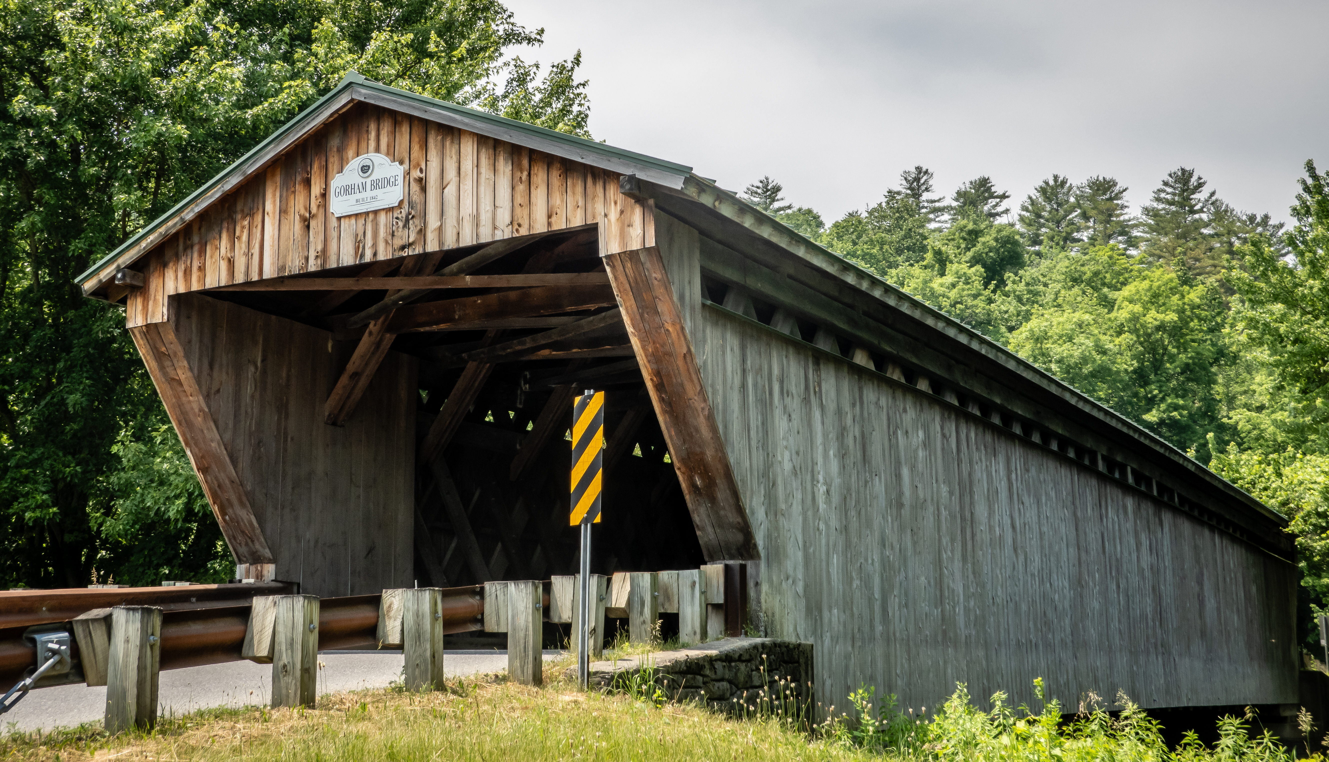
Our last stop was Gorham Bridge. Built in 1842, this 114 foot long bridge is still open to traffic to get over Otter Creek. There is a small parking area on the west side of the bridge that gives water access to the creek. I wasn’t able to take advantage of this to get a picture from below because there were too many tree branches in the way. We enjoyed our covered bridge tour of Pittsford Vermont.
 |
| Gorham Bridge |
 |
| Inside Bridge |
The next day a weather front moved through the area and brought us rather stormy weather. We were forecast to have several rainy days in a row but the following day looked slightly better so we attempted to get another hike in. This time we head to the town of Jerusalem northeast of camp. What had looked like decent weather when we left camp became less favorable as we drove into the mountains to reach the trailhead. By the time we got parked along the road next to the Jerusalem Trail, it was foggy and a little misty. We sat in the car and debated about even attempting this hike. It wasn’t just a question about whether the mist would change to a steady rain, but the hike we planned on doing was to a viewpoint. Generally views aren’t great when it’s foggy but since we know the weather isn’t expected to be any better for a few days, we decide to go for it even if the conditions aren’t great. We had a geocache to look for about a mile up and we figured we could go that far and bail going to the top of the ridge if conditions worsened.
 |
| At Jerusalem Trailhead |
The Jerusalem Trail climbs Stark Mountain from the west and intersects the very popular Long Trail that extends along the Green Mountains from the Massachusetts state line up to Canada. Getting up there won’t be super easy. It will be a steady climb of just over 1900 feet in elevation gain over 2.2 miles - or an average slope of 16%. By the time we started up the trail, the mist had stopped but everything was covered with water and wet. The trail itself was in decent shape and didn’t have running water.
 |
| Mushrooms Along Trail |
For the first mile or so it was more like an ATV trail that doesn’t get much use. But it became clear over that distance what the main use of the trail is - to act as a super ice road for a maple sap collection system. We had just seen our first Vermont sap collection tubing system when we visited Shelburne Farms a few days ago. We had thought their system was pretty elaborate. Well the system here was several times bigger and since it went into the woods on either side of the trail as far as we could see, it could easily be an order of magnitude bigger. I was fascinated to see what must be miles of what appeared to be 3/8 inch tubing that would come from the thousands of maples trees in the woods here - some larger trees with 2 or 3 tap points. This tubing would collect into larger tubing and eventually head into tubing that was so big it would more appropriately be called pipes. We never saw a sugar shack or collection building at least in this part of the woods but it would need to be a really big place given the pure number of tap points.
 |
| A Maze of Sap Tubing |
 |
| Complicated Junction Point |
We made it to the halfway point and after 10 minutes of searching around the woods and avoiding the maple sap tubes, we found the cache that hadn’t been found in over two and a half years. We decided that although it was slow going given the steepness of the trail, we would continue to our original destination despite the weather. The tubing stopped shortly after the halfway point. At first I assumed it was a property line thing but I began to notice that even though the woods were just as dense with trees, it was no longer predominantly sugar maples. In fact, I wasn’t seeing any maples, mostly birch and beech. We had a brief stretch of mist again as we neared the summit and the intersection with the Long Trail. The last few hundred feet was a tough rock scramble only made more difficult by the wet surface.
 |
| A Rocky Final Climb |
 |
| Steep, Wet and Mossy |
We got to the Long Trail and took a left to head north. Not that Canada was our goal but the Orvis Overlook was just a few hundred feet away and once we were along the ridge the hiking was actually pretty pleasant. We found a rock to sit on at the overlook and ate our lunch. The fog was rather intense and about all we could see at first were the trees only 30 feet away - there was no distance view whatsoever.
 |
| Lunch Spot at Orvis Overlook Minus the View |
Twenty minutes later as we get up to begin our descent, the fog had lifted slightly and we could at least see another forested hill to the west. It wasn’t the best view but it was a great workout to get here. The most difficult portion of the hike down was the rock scramble right near the top. Once we were past that it was smooth sailing.
 |
| A Slightly Better View |
 |
| Mountain Ash in Bloom |
 |
| Thick Moss Covered Rock |
There were actually a fair number of flowers in bloom. These seemed even more interesting since they all had a coat of dew covering them. We made it past all the sap lines and made it to the car without to much difficulty.
 |
| Delicate Flower |
 |
| Bunchberry Bloom |
Our drive back to camp took us right past Bristol Rock that we had attempted to walk to after our hike to Bristol Ledges. Driving there is the best way to see this thing since there is a rather large parking area right next to this unusual spot. Also known as the Lord’s Prayer Rock, this huge boulder has the Lord’s Prayer carved into the large face of the rock that fronts the road. A Vermont physician had the words carved into the rock in 1891. It was said that Dr Greene used to haul logs on a wagon to a Bristol sawmill as a young boy. It was a treacherous journey but when he reached this rock, he knew he had made it past the challenging part of the journey and he would recite the Lord’s Prayer to thank Him for getting him safely out of the mountains. It’s about 20 feet wide at the base and probably about 8 to 10 feet tall. The only problem with checking out the rock now is how close you are to the traffic that is whipping by on the road.
 |
| Bristol Rock |
We had three days of rainy weather including some stronger storms that had our weather radio going off like crazy. Once the storms passed, we had a stretch of decent weather and we took advantage of it to get in a hike to the 5th highest point in the state of Vermont. I mentioned earlier in this post about how popular the Long Trail is as it passes along the length of the Green Mountains. The hike to Mount Abraham follows a section of the Long Trail out of Lincoln Gap. Listed as a “hard” route in AllTrails, this 4.8 mile out and back hike will gain 1735 feet in elevation. Knowing this will be a challenging hike for us, we get a relatively early start and get to the trailhead parking by 9:30.
 |
| At Trailhead in Lincoln Gap |
The first half mile turns out to be somewhat flat and makes me wonder when we will start what we know will be a good climb. The next 2 miles of the hike are pretty steep with an average grade of 15%. We didn’t have any geocaches hidden along this trail to give us an opportunity to have an extended breather. I’ve joked with Chris that I think the number of pictures I take of flowers, animals, mushrooms and other things along the trail is in direct proportion to how steep the trail is. Stopping to compose a photo is my way of getting in a short break. Here’s some proof of how steep the climb up Mount Abraham was!
 |
| Red Spotted Newt |
 |
| Squirrel Ignores Us |
 |
| Mushrooms |
 |
| Big Toad Blends In |
The trail is rather rocky in spots and there are also some huge glacial boulders that we pass by. With all the recent rains, we did have a section of the trail that looked more like a stream than a footpath.
 |
| Rock Outcropping on the Trail |
 |
| In Between the Boulders |
 |
| Footpath or Stream? |
Just over 1.5 miles up the trail is an intersection with the Battell Trail coming up from the west. There were a few geocaches hidden along that trail and for an instance, I debated about going the extra half mile or so out of the way to try to find one, but then I realized that we would have to go downhill about 500 feet and then come back up that distance and decided that we didn’t need to make this hike any more difficult that it already would be. There is a shelter near the trail intersection and even an out house albeit one with an unusual note posted on its door - “Please Do Not Pee in this Toilet”.
 |
| Battell Shelter |
 |
| No Number 1 Outhouse! |
We continue up the trail after taking a break at the shelter and talking with a woman that was through hiking a portion of the Long Trail with her dog. We thought we were doing okay and would be at the summit in no time. But at the 2.2 mile mark, we discovered we had more obstacles to overcome. We were near the peak, but that also meant we had reached the bare, exposed granite. We hit several portions where it was clear that the trail went up a rock face, but it wasn’t clear exactly how we were supposed to do that. The good news was the rock had pretty decent traction and were pretty solid so it didn’t feel like we were going to constantly slip with our next step, but it was really slow going when the slope is over 30% at points.
 |
| And the Fun Begins |
 |
| View from Halfway Up the Rock Climb Portion |
 |
| But More to Go |
Once we made it to the summit, the 360 degree views were worth all the effort to get here. We found a large number of rocks piled up into a bench of sorts and sat down to enjoy our well deserved PB&J sandwiches.
 |
| Lunch Spot Atop Mount Abraham |
 |
| Great View in All Directions |
 |
| A Little Hazy to the West |
 |
| Looking North |
Our break lasted 20 minutes or so and in that time a couple dozen people likely passed by the summit. Some stopped to enjoy the view but some of the more serious hikers needed to keep moving since there is always another summit to be climbed just down the trail. We had read about there being a plane crash site somewhere near the peak of Mount Abraham but hadn’t gotten exact coordinates prior to coming on the hike. As Chris and I were talking about trying to see if we could find this site, one of the others hikers near us overheard our conversation and was also interested to look for it. We headed off based on the little information we had and found a few minor trails off the Long Trail that we thought might get is to the plane wreck but we weren’t having any luck.
We did get a chance to talk with our fellow searcher and found out he was in Vermont for the summer working as a counselor at a summer camp for kids. We had almost given up finding the wreckage and were joking with our buddy that as geocachers, it’s pretty bad when we cannot find a Cessna hidden in the woods! We made one more attempt to follow the Long Trail and then I spotted a small rock cairn on the side of the trail about 400 feet north of the summit on the western side of the trail with an obvious side trail into the woods and there it was.
 |
| Small Section of a Wing? |
There were a couple of sections of larger debris scattered over a hundred feet or so. This Cessna had crashed on June 28, 1973 with three occupants. Miraculously, they all survived and even hiked out from the crash! Given the circumstances of this incident, we didn’t feel too creepy checking out the debris field.
 |
| The Majority of "N92431" |
 |
| Looking Inside Cockpit |
 |
| One Last Look from the Top |
By now we had spent nearly an hour at the top and we needed to start the long hike back down. We were not looking forward to the rock scramble and found we likely went down the steep parts more slowly than we had come up. We had to let several others pass us as we made our way down to the saner section of the trail. When we made it to the Battell Trail, we still decided that it wasn’t worth the extra energy to go find the geocache and we just slowly made our way back to the car. With the extra distance added by looking for the plane, we likely were somewhere between 6 to 7 miles total but it was one of our favorite hikes in a long time.
 |
| Butterfly Poses |


No comments:
Post a Comment