Map of this blog's locations click this link to open the map
Back in January when we were planning our summer in the New England area, we had booked a spot for the month of June in the Green Mountains of Vermont and the month of August near the White Mountains of New Hampshire. Of course that did leave us with the month of July to account for. We knew we wanted to visit northern Vermont and possibly get back to Burlington but we still needed to fill in some time. I realized that we really haven’t seen much of the Adirondack Mountains during the past 8 years of full time RV living.
When we lived in western New York, we would visit the Adirondacks numerous times although often in the winter months for cross country skiing. We looked around the region for camping and found Macomb Reservation State Park on the eastern side of side of the mountains in the Plattsburgh area. While not technically within the Adirondack Park boundaries, it is just a few miles away and better yet, it is only about 80 miles from our campground in the Green Mountains. Being a state park, the campsites only have 30 amp electric and no water or sewer at the site. But we know we can easily make our fresh and waste water holding tanks last for 2 weeks when we have access to the bathroom facilities at the state park. So we had booked the first two weeks of July back in mid January. The drive there has us going to the southern end of Lake Champlain to cross into New York and then up through Port Henry and Westport before following Interstate 87 north. The drive through the small towns was very hilly and twisty but not too bad for our 38 foot motorhome pulling our Jeep.
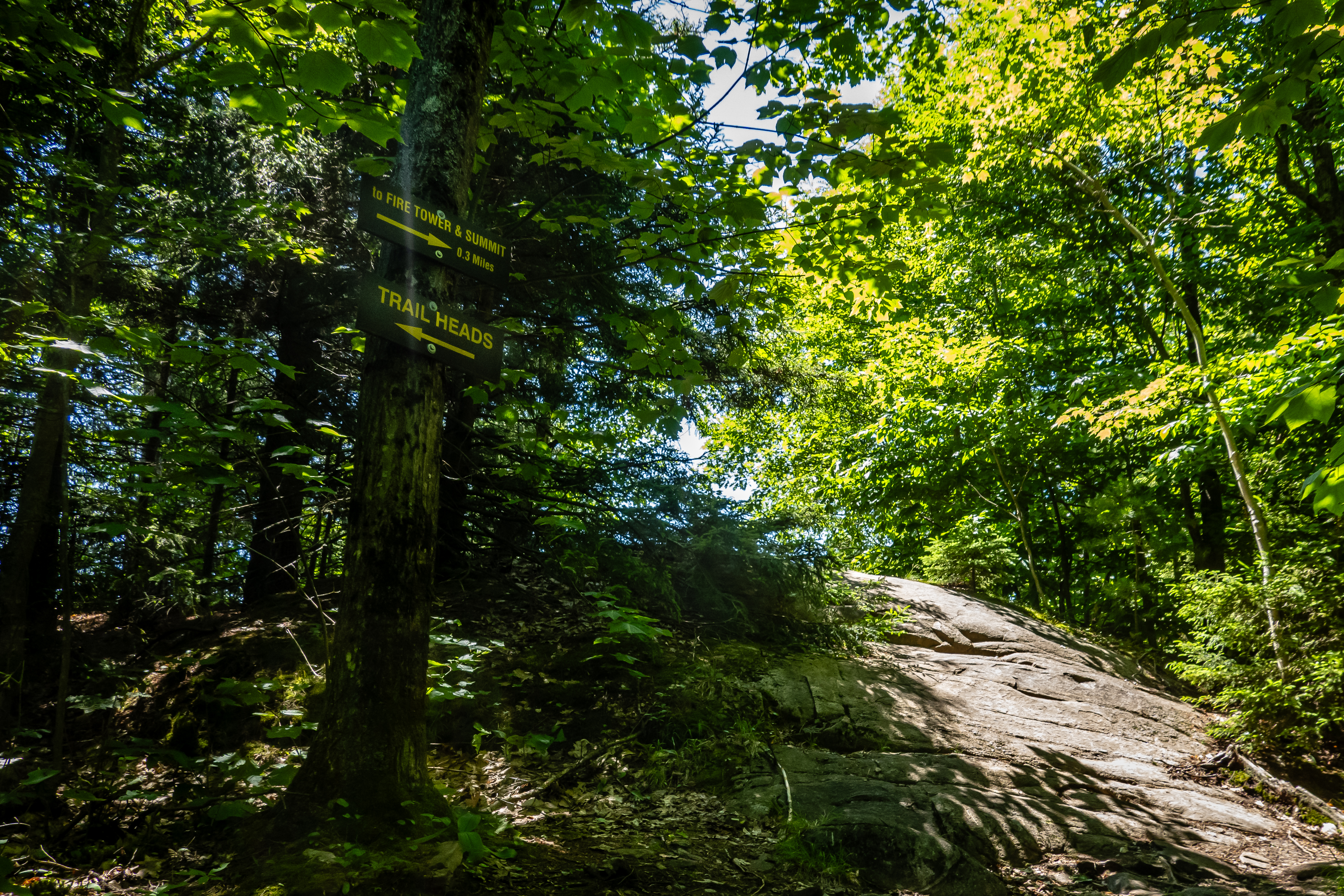
Coming into a state park on a Monday has its advantages. The place was pretty empty since the Fourth of July crowd hadn’t arrived yet. We get setup and start planning for our stay. The next day we start out with a hike in the mountains. Pokamoonshine Mountain has two different approaches. The Ranger Trail is listed as a 3.5 mile out and back with 1315 feet of elevation gain and rated “hard”. The Observers Path is 4.8 miles with 1437 feet elevation gain but rated as “moderate”. The two trailheads are one mile apart from one another along US Route 9. We head to the northern trailhead and plan to hike up the steeper Ranger Trail and possibly take the other trail down. The goal is to get to the top and check out the views and the fire tower at top.
 |
| Fire Tower Atop Pokamoonshine Mountain |
It is a pretty trail but fairly noisy since the majority of the hike is within a mile of the interstate so there is the constant sound of distant vehicles. It is also rather steep and rocky. The first mile and a half has an average grade of 15%. The are also lots of huge boulders strewn along the side of the mountain and plenty of nicely constructed stone steps. We came upon a hiker heading down and we stopped to chat with him. Being a local, he was able to give us some insight to some other nearby hikes that might be in our future.
 |
| BIG Rock |
 |
| Mossy |
 |
| Stone Steps |
We do have a few geocaches to find along the hike which gives us a break from the climbing. One of them is located a half mile up the trail at our first clear overlook. It took us several minutes to spot this one but enjoyed the view while we searched.
 |
| First Viewpoint Along Trail |
Further up the trail, we get another opening with a great view to the south. The trail has been in excellent shape and other than how steep it is, it has been quite pleasant.
 |
| Well Constructed Wooden Stairs |
 |
| Another Viewpoint |
 |
| Rock Lined Trail |
We intersect with the Observers Trail 1.3 miles into the hike. It is still another half mile to the summit but shortly after the junction, we find the modern shelter as well as the stone chimney remains of the Observers Cabin. Built in 1936, the fire observer would live here roughly 6 months of the year during fire season and use the fire tower on the summit to view the surrounding area. The cabin burned down in 1993 from a lightning strike. There were observers working here until 1988! It was interesting to read about the place and imagine living here for the summer.
 |
| Blue-Bead Lily |
 |
| Observer's Cabin Stone Chimney |
The last push to the top is still steep. There is more large exposed rock surfaces to walk on as we get higher up. There is another opening with some more nice views before actually reaching the summit and the tower.
 |
| Last Turn Before Summit |
 |
| Last Viewpoint Before Summit |
 |
| Nice View |
 |
| One Last Climb |
We finally made it and had an excellent view. We had mainly clear skies and it wasn’t too hazy so we could see quite a distance to the south and the east. Lake Champlain was quite visible and we had climbed a few of the peaks in the Green Mountains to the east. There were only a couple other people up here and we found a spot to sit down and enjoy the views while eating lunch.
 |
| View at Top of Pokamoonshine |
 |
| Lake Champlain and Vermont |
The fire tower enclosure was locked however the stairs up to the base of the room was open and it does provide for a slightly better view even with the metal framing in the way. We have one last cache to find up top. It is a few hundred feet from the tower and brings me to yet another viewpoint.
 |
| Near the Top of Fire Tower |
 |
| Fire Tower View from Near Geocache |
We start our journey down and decide the legs have enough energy to turn the hike into a loop. So rather than a 3.5 mile out and back hike on the Ranger Trail, we will end up with 7 miles coming back down the Observers Trail and then taking the road back a mile to the car. But it turned out to be a nice decision since there were a couple of nice ponds/swamps to stop and check out on the more gradual downhill trail. This trail definitely doesn’t seem to get as much foot traffic but was still in good shape. The worst part of this loop was the walk along the road. There is a reasonable shoulder and very little traffic but it is far from scenic and rather noisy from the expressway several hundred feet away. All in all a very nice hike.
 |
| Pond Along Observers Trail |
 |
| Swampy Area |
 |
| Bright Mushroom |
Since there are lots of hikes in this part of the state, we head out for another one the next day but decide to go with a slightly shorter one - Rattlesnake Mountain. This one is under 3 miles out and back and has just under 700 feet of elevation gain so it should be a bit easier on the legs. The drive to the trailhead is about the same as yesterday’s but is a bit further east and not near the expressway so it might be a quieter hike. The parking lot isn’t huge but we find a spot and start up. The first mile of the trail is a very nice path in the woods and not very steep.
 |
| Nice Trail Through the Woods |
But the last half mile starts to climb pretty good and the trail becomes much more rocky. At one point as we were nearing the top, I missed a trail marker and was staring up a very rocky climb. It looked much more intense than we were expecting and as I scan the area, I notice that there was a turn I missed and there was a more manageable climb to the top.
 |
| A Rocky Trail |
 |
| NOT Direction of Trail |
 |
| This Way Instead |
Up top there was one geocache for us to look for before enjoying the views. Lake Champlain is quite visible as are some of Green Mountains of Vermont. There are also a few smaller lakes or ponds that must be on the New York side. We sat and enjoyed our lunch and just as we were heading down, a group of young girls were arriving - probably a Girl Scout troop. Surprisingly they were being relatively quiet so their presence wasn’t going to impact the other small groups that had made the hike up. The hike back down to the car was uneventful and the legs agreed that this was a good length after a long hike yesterday.
 |
| Rattlesnake Mountain View |
 |
| Lake Champlain View |
 |
| Nearby Smaller Lake |
Since it was still early in the afternoon, we head into Keeseville check out some historical bridges with the help of an Adventure Lab. The Ausable River runs through the heart of the cute little town. The swing bridge is for pedestrians only. Built in 1888 it spans about 150 feet across the river. It definitely lives up to its name by swinging all the time we are walking across it. It it does provide for a good view of downtown and the next bridge we are heading to.
 |
| Crossing the Swing Bridge in Keeseville |
 |
| Ausable River View |
The stone arch bridge built in 1843 was very pretty. There were a few plaques mounted on its side wall showing the water level during some historic flood. From here, we get a better view of the swing bridge upstream of us as well as the rapids over some exposed rocks in the middle of the river.
 |
| Side View of Swing Bridge |
 |
| Beautiful Stone Building |
 |
| View of Anderson Falls in Keeseville |
A small park on the eastern side of side of the river gives a close up view of the bridge, Anderson Falls and old mill. A third of a mile south of the swing bridge was another old bridge built in 1878. This one was open to traffic until 2008 but from the looks of things, it would still likely support pedestrians.
 |
| Anderson Falls |
 |
| Closed Liberty Street Bridge |
Our next two bridges were several miles north at Ausable Chasm. We vaguely remember visiting here back in the late 1980’s but don’t recall much about the place other than the amazing gorge that the river has carved out over the years. The land around the chasm is privately owned and has been turned into a very popular tourist destination. But that also means that if you was to do more than just look down into the river from the main road, visitors will need to spend some money. Just to walk the 5 miles of trails along the river is $20 per person. Then they offer all sorts of rafting, an adventure trail (via ferrata) and even rappelling into the chasm - with prices from $50 to $225!
 |
| Ausable Chasm |
 |
| Falls at Ausable Chasm |
Being the day before Fourth of July, the place was very busy. We needed to check out some of the bridges to complete our Adventure Lab so we avoided the main entrance and headed up a side road. At no point did we cross a barrier that mentioned the area was for paying customers only, but we did seem to be the only people wandering around without some colored wristband on. After finding our bridges, we headed back to the car through the area next to the main visitor center. There was a large group of people watching someone giving a talk so we stopped to see what was going on. He had barred owl that he was showing off to the crowd. I can see why this place is so popular but it definitely isn’t our style of entertainment. So we work our way back to the car and head home.
 |
| Dam Across Ausable River Above Chasm |
 |
| Barred Owl |
 |
| Impressive Stonework |
 |
| Looking into Ausable Chasm |
The next day we head just north of Dannemora to hike the Spring Trail in the state forest. But when we arrived at the trailhead, it looked like this trail hadn’t seen any foot traffic or maintenance in quite some time. I suppose if we had worn long pants, we might have at least tried it but we come up with a plan B and head to the nearby town of Cadyville to a small park with a handful of geocaches hidden along the trail. Being the 4th, we were really expecting there to be families picnicking but we found the park nearly deserted. The trails were okay and we found 4 of the 6 caches we looked for. Being a hot day, a short walk in an empty park worked for us.
 |
| Trail in Caddyville Park |
One of our favorite destinations in the Adirondacks when we lived in western New York was Lake Placid. Since it was a 5 hour drive from our old home, we didn’t get there too frequently but always enjoyed it whether we came in the winter for cross country skiing or during fall foliage season. From our present campground, Lake Placid was only about a 45 minute drive so we headed off early the next morning to explore the area again. Our first stop would be for a hike at Mount Van Hoevenberg.
 |
| Entrance to Mt Van Hoevenberg |
A little bit about about Lake Placid. While it’s a popular tourist spot year round, it is likely most popular for its winter activities like cross country and downhill skiing. The town was the host to two Winter Olympic Games in 1932 and the one I remember in 1980. This is where the “Miracle on Ice” took place between the USA and USSR in the first game of the medal round in ice hockey. Lake Placid had created quite a few venues in and around town to host all the various events. Most of these places are still in use today and many of them have year round activities for the outdoor minded. Our goal is to hike the Mt Van Hoevenberg East Trail. It’s a 3.2 mile out and back hike with about 900 feet of elevation gain. There are more challenging hikes in the area but from what we have heard, this hiking trail was built fairly recently and has some very well thought out trail building techniques that are being evaluated and might get implemented on other trails in the future. It starts out at the very beautiful Mountain Pass Lodge.
 |
| Mountain Pass Lodge |
 |
| Olympic Awards Platform |
We chat with one of the park rangers about this trail before we head out. For those not interested in a hike, there is the option to ride the cliffside coaster. We didn’t investigate this much but it did look like fun.
 |
| Cliffside Coaster |
 |
| Coaster Starts Climb |
As expected, the trail was in excellent shape even with the large number of other hikers out for the day. The steeper sections of trail were constructed with large stone steps. Hiking this trail definitely made me wonder about the actual construction techniques used to install the large rocks and steps. Coming up with a plan for a trail up the side of a mountain is one thing, but actually implementing it is what fascinates me. Maybe I just did a lot of thinking about how the trail was built as a way to catch my breath during the steep climb.
 |
| Stone Stairs on East Trail |
 |
| Bridge |
Mt Van Hoevenberg isn’t the highest peak in the area, but it still provides for an excellent view from the top. There are a two different rock outcroppings that provide for a good area to sit and enjoy the view. We had our lunch up here but one couple had hauled a couple of folding chairs with them so they had a comfortable place to sit.
 |
| Pretty Nice View from Mt Van Hoevenberg |
 |
| Meandering Stream in Valley Below |
We had definitely picked a great day weather wise. There were some clouds but it wasn’t too hazy so the views were excellent. The end result was definitely worth the effort and I will say this was one of the nicest trails we have hiked.
 |
| A Good Spot for Lunch |
 |
| More Mountains in the Adirondacks |
 |
| Don't Get Too Close to Edge |
The hike back down was nice and there seemed to be a constant stream of people coming up. This is definitely a very popular trail. I suppose it’s the combination of the great views with somewhat minimal effort. Let’s just say, we have done some much more challenging and longer hikes to have mediocre views so the East Trail was a winner.
 |
| The Outhouse Needs Some TLC |
 |
| Moss Covered Rock Wall |
 |
| Pretty Flower |
Our next stop was to check out John Browns Farm. This is the same John Brown that we learned about during our visit to Harper’s Ferry back in May. Well it turns out that John lived on a small farm near Lake Placid and it is now a state historic site. We knew there were some hiking trails, some geocaches and some buildings to tour. What we didn’t know was there was a large event taking place about an hour after we arrived. A new statue of Harriet Tubman was being unveiled. Our goal to get the guided tour of some of the buildings didn’t go as planned but we did get to step inside before the volunteer closed up for the event.
 |
| Inside John Brown's Cabin |
 |
| Bedroom |
 |
| Kitchen |
We got past the statue and to some of the trails prior to the event starting. I think we only saw one other person on the trail. Most of the people in the crowds were definitely not the type of folks we would see on the trails - at least not in their suits and dresses! The trails were pretty nice and the geocaches were in decent shape. One of them was a huge plastic tote that is far from standard.
 |
| Harriet Tubman Statue |
 |
| Pond and Barn |
 |
| Very Large Geocache |
 |
| Nice Trail in Woods |
The other neat thing about this spot is we are right next door to the two ski jump towers. This is another popular destination to get tickets to ride to the top of the ski jump. We pass on this opportunity as well.
 |
| Ski Jump Towers |
By now it mid afternoon and we still hadn’t made it into Lake Placid proper. Traffic and parking was a real problem. I guess it didn’t help that it is a holiday weekend. We eventually find an open parking spot and pay for 3 hours of parking. It wasn’t clear we would be good for that length of time but we would give it a shot. Our first stop was at the Olympic Center. This is a large complex of buildings that includes both the 1932 and 1980 ice rinks. The Zamboni was out when we first went thru the 1932 arena.
 |
| 1932 Ice Rink |
Next door is where the “Miracle on Ice” took place in 1980. Today, there was a team of kids practicing. They must have just been finishing up since they all came together at center ice and the coaches were giving the team his thoughts. We wandered around the complex and caught a band playing to a group of about 5 people. I felt kind of bad walking past them and not stopping to listen but we had more to see. By the time we made it back to the 1932 rink, a couple of kids were out practicing their figure skating.
 |
| Kids Practicing on 1980 Rink |
 |
| End of Practice |
 |
| Figure Skater on 1932 Rink |
As we exited the building, the Zamboni was dumping its load of ice into an area right next to the main sidewalk. People were waiting nearby to grab some and make snowballs to throw at one another.
 |
| Zamboni Dumps Ice |
We walked south to the speed skating oval. The street is lined with flags from all the countries that participated in the Olympics in Lake Placid. It didn’t seem like there was much more to see south of here so we turn back and slowly work out way north.
 |
| Flags of the World |
 |
| Olympic Center |
We head down to the very popular mirror Lake Public Beach. There were lots of people on the water in kayaks and paddle boards and even more people on what looked to be a nice sandy beach.
 |
| Paddling Mirror Lake |
 |
| Busy Beach |
Besides the Olympic specific buildings, Lake Placid is full of small shops and restaurants. We wander in a few of them but don’t find anything we really need. But just about any type of souvenir is available for people that have more space than we have in our motorhome! We do eventually find and ice cream place that looked good. There was a long line but we took that to mean it was a good choice. Emma’s Lake Placid Creamery was a great way to end the day. We sat on a bench across the street and people watched as we finished our cones before heading back to camp. It was a full and varied day.
 |
| Another Mirror Lake View |


No comments:
Post a Comment