Map of this blog's locations click this link to open the map
Our next destination is to Indiana Dunes in far northern Indiana on the shore of Lake Michigan. There are two places here - Indiana Dunes National Park (IDNP) and Indiana Dunes State Park (IDSP). While the state park is roughly one tenth the size of the national park and completely surrounded by it, the campground in the national park has about half as many campsites as IDSP and has a 35 foot maximum RV length which won’t work for us. We’ve also heard better things about the state park campground so we had reserved a site for 4 nights starting Sunday June 1.
Like most campgrounds, there are check-out and check-in times. Usually these times are separated by an hour or two which, in theory, permits the staff to clean up the sites from the previous guests and allows the site to actually be available for the incoming guest. The first unusual aspect to IDSP is the check-out and check-in times are the same - 2PM which is a reasonable time. But the other unusual rule is that on Sundays and holidays, this time is pushed back to 5PM! I understand the premise that those weekend campers want to maximize their time in the park before heading back home, but it isn’t like the park empties out on Sunday until the next weekend so those people coming in on a Sunday are at a big disadvantage. It was around 170 miles from the casino to the campground or roughly a 3 hour drive. The good thing about staying at a casino is there really is no checkout so we are able to chill until well after lunch before heading out. Partway along the drive, Chris realizes that we are heading from the Eastern Time Zone to Central, so we are still going to arrive an hour earlier than we expected. Fortunately we were able to find a large enough parking lot along the way and pull over to kill another hour!
We have 3 full days in the area and come up with a strategy of how we plan to fill them. For day one, we head just down the road from our campground to the national park visitor center. We explore the displays inside and what the movie about the park. Previously a national lakeshore, it wasn’t until 2019 that it became the 61st national park. We stamp our passport and pick up a map to come up with a strategy for our visit. Outside there are actually 3 geocaches hidden around the visitor center which is unusual for a national park.
 |
| Visitor Center at Indiana Dunes National Park |
 |
| Colorful Bison |
 |
| Old Plane Above |
The park is spread out over about 20 miles with lots of individual parcels. We knew there was a lot to see if we attempted to get to them all so we selected a few locations to see and head out. Our first stop is Mount Baldy. If you are expecting a true mountain in northern Indiana, you will be disappointed since it is only 126 feet tall. What makes this place at the far northeastern edge of the national park worth seeing is a “living” sand dune. Wind blowing off of Lake Michigan is constantly changing this huge sand dune. It was quite apparent when we pull into the parking lot to look around just how active this place is. The edge of the dune was encroaching into the parking lot. It wasn’t completely clear during our visit just how much Mount Baldy has moved over the years but I later went into Google Earth and used the historical satellite imagery to get a better look. I pulled up the most recent image from a little over 6 months ago and time traveled back to look at how much it has changed. The montage below has 4 images that go back about 14 years. It turns out that the parking lot used to have a whole other section to it which is now completely covered. It has moved 82 feet in those 14 years! It’s unclear if the park service plans to try to save the building here or will let it succumb to the forces of nature?
 |
| Mt Baldy Parking Area |
 |
| Dune Encroaches Parking Lot |
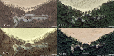 |
| Mt Baldy Progression Over Time |
 |
| Full Size Trees Succumb to the Dune |
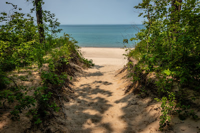
Over the years, visitors hiking to the top of the dune have become a problem so now it is illegal to hike up to the top other than on ranger guided tours - of which there are none scheduled during our stop here. It is however possible to take a trail around the perimeter of the dune and out to shore of Lake Michigan.
 |
| Approaching Lake Michigan |
There were only a handful of people out on the beach. To the north is a power plant in the town of Michigan City. We walk along the beach for a time hoping to see the Chicago skyline in the distance but it was much too hazy for that. It is possible to get a good view from the lake side of Mt Baldy.
 |
| Looking North on Beach |
 |
| Looking South |
 |
| Closeup of Power Plant |
 |
| Mount Baldy |
Heading southwest, our next stop is to the Century of Progress Homes. Located along the shore of Lake Michigan are 5 homes that were originally built for the 1933 Chicago World’s Fair. A real estate developer had the homes moved after the fair with the hopes of creating a resort community along the lake. That never panned out and today the homes are part of the park system and are actually leased out to private individuals. As part of the lease agreement, the owners open the homes to the public one day a year. They are interesting to check out from the road. If I were to live in one of them, I might find it difficult to have a steady stream of sightseers walking by. One of the homes, the House of Tomorrow, is receiving a major renovation.
 |
| Florida Tropical House |
 |
| House of Tomorrow Under Renovation |
 |
| Weiboldt-Rostone House |
We wanted to stop at the nearby Dune Ridge Trail for a short hike. We pulled into the parking lot and found it to be full. We were surprised that nearly 100 people wanted to do the under 1 mile hike but then realized that this is also the parking for Kemil Beach a quarter mile down the road. We did a second pass but gave up and headed on to the Bailly Homestead and Chellberg Farm. There are several buildings on the property that dates back to the 1870’s and is now part of the national park. We have 5 geocaches hidden along a mile or two long trail system.
 |
| Log Outbuilding |
 |
| Maple Syrup Bucket/Geocache |
Some of the old buildings are in the middle of a complete restoration project and part of the crew was working on one house as we wandered by. We enjoyed reading the interpretive signs along the way to help imagine life here a century ago.
 |
| Bailly Homestead Major Renovation |
We thought the old farmhouse was to have goats but we didn’t see any - just a few chickens. The old sugar shack for boiling down maple sap looks like it may still get used based on some of the new looking stainless steel equipment. We managed to find all the geocaches on our walk and had an enjoyable time.
 |
| Chickens |
 |
| Chellberg Farmhouse |
 |
| Bearded Iris |
 |
| Virginia Waterleaf |
 |
| Sugar Shack |
We headed up the road from the farm to Cowles Bog with the plan to do the 5 mile loop hike. It was fairly late in the afternoon and we decided we had spent too much time with our earlier sightseeing trips today to fit in what was described as the park’s most rugged hike. Plus there were no geocaches to entice us so we head back to camp.
The following day our plan is to concentrate on seeing what the state park has to offer. The advantage is we can hit all the highlights without the need to drive anywhere. We first head over to the nature center right next to the camping area. A geocache near the building called “Buzz Off” was creative. Designed to look like a hornet nest in a tree, most non-geocaches probably wouldn’t see it since it was pretty high up, but even if they did, they would likely not want to get too close for fear of getting stung. But we knew all we had to do was loosen the rope and lower the fake nest to sign in.
 |
| Realistic Hornet Nest Hanging in Tree |
The nature center wasn’t very big but did have some good displays and several cages and terrariums with some animals that were actually awake and moving around.
 |
| Ribbit |
 |
| Giant Salamander |
 |
| Gartersnake |
One of the hikes in the park that gets a lot of publicity is “The 3 Dune Challenge”. This 1.5 mile loop goes over Indiana’s three tallest dunes. It sounds impressive and there are t-shirts and hats in the visitor center for those wanting to proudly show you completed the hike. There is only 550 foot elevation gain so it isn’t all that impressive, but I will give them credit for good marketing. The hike starts from the nature center and starts a bit of a climb. It was a fairly shaded trail and not completely sandy so it was even easier than we were expecting. When we got to the crest of the hill, I checked our map to confirm we were at the top of the first “mountain” - Mount Jackson.
 |
| Starting the 3 Dune Challenge |
 |
| Spiderwort |
Turns out we had been fooled. The little climb we did was NOT the first mountain. We still had a quarter mile more before we get to the top of Mount Jackson. Then the trail turned into pure sand - not hard packed sand but very loose and deep sand and it was a slope of almost 20%. I found some lupine in bloom on the way up and was able to use them as an excuse to stop.
 |
| The Real Climb Begins |
 |
| Lupine |
The view from up top was decent although we couldn’t quite see the lake. It was only another tenth of a mile or so to come down the first climb and then to the peak of Mount Holden. It was still deep, loose sand but at least we could see Lake Michigan from here.
 |
| Atop Mt Jackson |
 |
| Spiderwort |
 |
| View of Lake Michigan from Mt Holden |
The climb to the last peak - Mount Tom was equally steep but they have constructed a set of stairs up and down so at least you don’t lose ground with each step like we do in the sand. The loop trail technically continues downs the stair in front of us but we had decided to follow Trail #8 which should head down to the beach and go check out the more popular area for visitors.
 |
| Staircase to Top of Mt Tom |
 |
| Stairs Down - Not Taken |
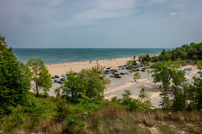
It was an easy walk down off the dunes to the beach. There weren’t many people to the east but we could see probably over 100 people to the west at Waverly Beach.
 |
| Approaching the Beach |
 |
| Nobody to the East |
The Dunes Pavilion is a lovely building dating back nearly 100 years. We didn’t check out the inside but it appears to have food options and an ice cream window on the one side. One corner of the building is for the lifeguards.
 |
| Dunes Pavilion |
One side of the huge parking lot for the pavilion and beach is something called Devil’s Slide. The sign mentions it is a popular place for sledding in the winter - I’ll take their word for it rather than stick around to find out first hand. We did a little bit of people watching. We didn’t go out into the lake but it must not be too cold since a good number of visitors were playing in the water.
 |
| Looking Up Devil's Slide |
 |
| Busy Beach |
On the back corner of the parking lot, we notice a large platform up on the dune. We find the trail and make our way up to the viewpoint. They even have a long ramp to the top making it handicap accessible.
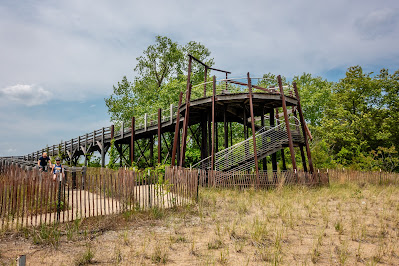 |
| Large Viewing Platform |
 |
| View of Beach |
We followed a couple of trails back to the campground finding one last geocache in the park. We ended up with 5 found caches and a 3.5 mile hike. I’m still not sure the 3 dunes should receive the title of Mount but it was a fun hike. There are many more miles of trails in the park but we need to save our energy for tomorrow when we head into Chicago - more on that in the next blog post.


No comments:
Post a Comment