The US Air Force Academy is located just north of Colorado Springs and is a popular destination in the area. We do a little research about getting onto the base and what there is to see and do for us civilians. We time our visit to see a movie showing at the planetarium on base. They typically have several shows on Mondays, Wednesdays and Fridays but not all movies are shown each day, so plan your visit accordingly. When we were there, we wanted to see the double feature on the Aurora Borealis and Black Holes so we headed there on a Monday. This base was one of the easier ones we have visited over the years. Fort Huachuca in Sierra Vista Arizona had a more elaborate background check that took about 30 minutes. The procedure at White Sands Missile Range near Alamogordo New Mexico requires a form to be filled out and a background check but that only took 10 minutes. To get onto the US Air Force Academy base, we really only needed to show a valid photo identification such as a driver’s license. They may also ask for proof of auto insurance and vehicle registration, but in our case the two drivers licenses worked fine. We asked for directions to the museum and planetarium and off we went, less than a minute to get in.
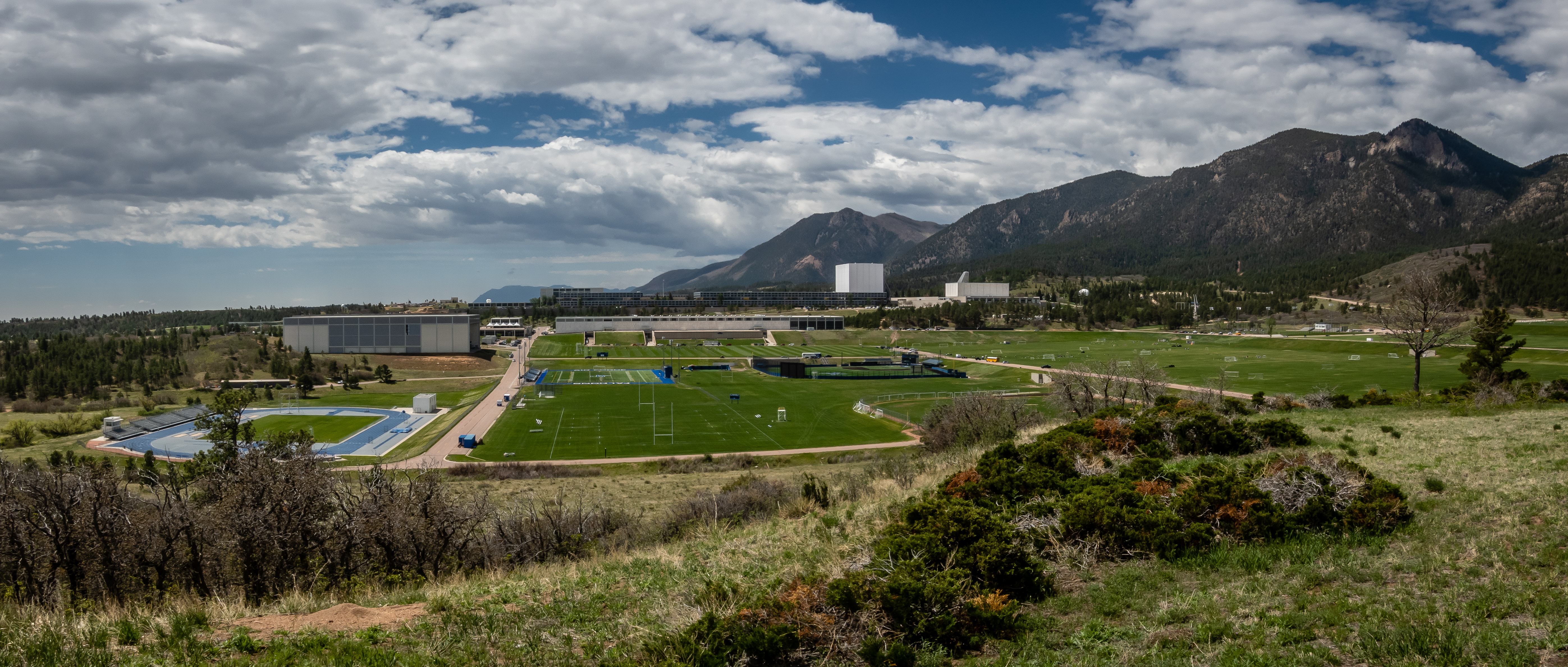
Heading up the main road from the North Gate entrance, we come upon an overlook parking area. This is definitely a very nice campus with an absolutely gorgeous setting with the foothills just to the west. One of the activities visitors often come to see is the cadet noon meal formation. Each cadet squadron marches across the plaza in formation to get their lunch. Unfortunately, our timing has us visiting in between class sessions so this wasn’t part of our tour of campus.
Overlooking USAF Academy Campus
We had allotted more time for traffic and getting through security so we arrived well before our scheduled movie time. The shows are free but are also first come first serve. There were a handful of people waiting but the place looked fairly large so we wandered the nearby campus area while we waited. Polaris Hall is an impressive building with its glass fin pointing to the North Star. The courtyard next to this building has numerous scale replicas of various airplanes. One rather odd looking building caught us off guard. It is a large rectangular box with many supporting struts on one side. It definitely did not fit in with the surrounding buildings. We would come to find out that the Cadet Chapel is hiding inside this box. It is undergoing major renovations and will not be open until 2027. The box keeps it out of the elements while the work is taking place. I grabbed a screenshot from Google Earth of what the chapel looks like.
Polaris Hall
Plane Replica
Fountains
Eagle Battle
Float Plane
Hidden Chapel
Google Earth Rendering of Chapel
With a short tour of the nearby area, we head back to the planetarium for our double feature. By now there were a few more people, but when the doors opened, we all filed in and grabbed a comfy chair. The place holds nearly 200 visitors but it was almost full when the show began. Photography of the shows wasn’t permitted but I did get a shot of the screen beforehand. The two shows were very good and the viewing environment was excellent. It turns out this building sat idle for 15 years before being renovated and reopened in 2019. I suspect any of the shows they have would be worth seeing. We even debated whether we should just stick around for the next show since it was going to be a different movie but we decided we had other places to visit on campus.
Planetarium
Waiting for the Show
As we head outside, we could tell a big rainstorm had passed through the area. I was surprised, since we hadn’t sensed anything taking place during the movie. The visitor center on campus is just a short drive from the planetarium.
Foothill Just Beyond Parking Lot
Visitor Center
There is a lot to see inside the visitor center. We spent about an hour or so just checking out the various displays. There is a movie that documents the life of cadets when they enter the Academy. There is also a very large gift shop with just about any type of shirt, jacket, hat or coffee mug with the Air Force logo on it. It was enjoyable even for us civilians.
Glider Inside
Patches
Model of Chapel
There is a trail from the visitor center to overlook the chapel but we decide to skip that view. Driving around the perimeter of the campus, we find a parking area with a short walk to another overlook. It give a good sense of the size and look of this side of campus. Just as we got to the overlook, the next storm rolled in and we barely made it back to the car before it began to pour again. Doolittle Hall has a majestic Pegasus statues out front. Since it was raining, we decided to skip heading inside for a visit.
Overlook on South Side of Campus
Outside Doolittle Hall
As we continued around the perimeter drive, we skipped a visit to the football stadium. We were unsure whether it was open to the public and the weather was still yucky. As we came back around the loop drive, we were at the B-52 Stratofortress display. It looked like the rain was just about over so we waited it out for a few minutes before wandering around the plane and the displays at the Air Warrior Combat Memorial. In all, we spent nearly 4 hours visiting the campus and watching a couple of short movies. It’s definitely a nice change of pace to do something like this on our travels. On the drive back to camp, we stopped at the Air Force Academy Airfield Overlook to check out the view from here. Falcon Stadium is clearly visible with the mountains in the background.
B-52
Rear View
Entrance to Combat Memorial
Air Force Fight Song
Falcon Stadium from Overlook on I-25
We received word from the Jeep service guy in Denver that they had identified and repaired a different fuel injector and we were now in good shape again. So we drove back up to get the car. Given the problems we have had thinking the car was repaired but finding out it wasn’t, we decided to leave the rental car at the dealership and go out for some caches in the area. This would hopefully give us a chance to confirm all is well before returning our third rental car in 2 weeks. All seemed good and we came back to Cheyenne Mountain to take a walk on some of the trails near camp. Being this high above the plains to the east of camp, we get a bird’s eye view of storms as they pass thru. There were definitely some dramatic clouds but for the most part we didn’t receive much rain at camp. This was a good scenario, I was able to get a camera out and capture a dramatic lightning storm out to the east without getting wet at camp. Video below.
Low Clouds on Cheyenne Mountain
Storm Clouds East of Us
Video of Storm
We had a couple days off without a hike so we picked another one to try not too far away. Mount Muscoco Trail is located in North Cheyenne Cañon Park. This park is known for its hiking trails. We had tackled two of them back in the fall of 2020. AllTrails lists nearly 50 hikes in their database so there is likely something for everyone. Mount Muscoco is a 4 mile out and back hike with 1300 feet of elevation gain.
Since Colorado Springs is at higher elevation than Denver, I guess we will see if we are up for a hike to just over 8000 feet. We did have a plan B, the first 2/3 mile of this hike is also the trail to Mount Cutler. If we aren’t doing well at the split in the trail, we could bail and do the shorter 1.7 mile out and back hike that has less than 500 feet elevation gain. The parking at the trailhead was almost full but we got a spot. Being 10 AM on a Wednesday, we were hoping it wasn’t going to be too crowded. The trail starts out uphill right away. In fact, this trail has a rather consistent 12% grade for most of the hike. What makes the hike worth the effort are the views. Even when we are still able to see the road below, there are excellent views.
Exposed Tree Roots Along Trail
Can Still See the Road Below
Beautiful Butterfly Poses
Tree Appears to Be on Tiptoes
At the split, we decide we are doing okay as long as we take our time. The weather was looking great so we continue to Mount Muscoco. At higher elevations, we are able to see some of the nearby reservoirs. Every now and then we can hear voices across the valley below us. We are able to get some views of what looks like a suspension bridge and maybe a zip line. We had heard of a place called Seven Falls near North Cheyenne Cañon Park but it is a private place that charges $17 per person to enter. We suspect what we are hearing and seeing are some of its guests. The trail heading up to Mount Cutler is also visible from our trail. That trail doesn’t look to be as forested and is quite exposed to the sun. I think we made the proper choice with this longer hike.
Reservoir View
More Climbing Ahead
Suspension Bridge at Seven Falls
Mount Cutler with Exposed Trails
Given all the cars at the trailhead, we really didn’t run into that many people on the trail. Those coming back down from the top must have thought we looked tired because they would give us encouragement that we were close, and it was worth it! We had a couple of geocaches along the way to give us something else to concentrate on. At the top, we were greeted with some outstanding views. We ended up being the only ones up here for the half hour we spent enjoying the views in all directions and having our lunch. From our spot, we were able to see the parking area for the Seven Bridges Trail as well as Helen Hunt Falls about 3/4 mile to the west.
Atop Mount Muscoco
Astounding Views in All Directions
Parking Lot for Seven Bridges Hike
Helen Hunt Falls
The hike back down was much easier. There weren’t that many steep or rocky sections to make for a challenging descent. At one point we could hear some jets flying overhead. With the tree cover and mountains in the way, it took us some time before we were able to locate them on one of their passes. I managed to get a picture of the 4 planes but wasn’t sure what they are. As we came back down, we notice lots of markers and flagging along the trail that wasn’t there on our hike up. We investigated the information on some of the flags and discover that there is a race this weekend called “Ring the Springs”. The distance options include a 28 KM, a 50 mile and a 100 mile course! Glad we weren’t trying to hike this trail with runners passing us the whole way up. Ours was a wonderful 4 mile hike, but we can’t imagine doing 100 miles of similar terrain.
Four Jets Overhead
Another Mount Cutler View
Small Cave
One of the other places we read about that sounded rather interesting is a place about 50 miles northeast of camp near the town of Calhan Colorado. The Paint Mines Interpretive Park is about 750 acres of brightly colored rock formations. From the pictures we saw, it looked like a combination of the Painted Desert portion of Petrified Forest National Park and Chiricahua National Monument. Much of eastern Colorado is rather flat and desolate looking but this sounded like it would be worth the drive from Colorado Springs.
There are a couple different parking areas and several miles of trail through the park. We started at the western parking lot and were a bit surprised to see more than a dozen cars. It seemed like most people were taking the trail to the south out of the parking lot since it is the most direct way to the best part of the park. We choose to go straight and follow the trail to a dry creek bed. Our main reason wasn’t just to avoid the crowds but to find a geocache hidden along this route. The walk up the creek bed is definitely much less traveled. From the looks of things, there is likely a good flow of water through here after a storm but it was bone dry for us. The views along this trail were mediocre without much coloration in the eroding soil of the creek walls.
Paint Mines Entrance
Walking Up Dry Creek Bed
It ended up being about a mile hike to get to the good part of the park whereas the other more direct route was half that distance. Now it’s clear why that trail isn’t used very frequently. I suppose one advantage of the route we took is that we are up above the formations and can get a good overview of the area. We sit on a bench at the overlook and just take it all in.
A Few Flowers
What a View!
Looking Into Colorful Area from Above
We head down the trail and enter the heart of the formations. Climbing on the formations is not allowed but there is still a lot to explore in some of the smaller paths back into dead end passages. There isn’t a lot of plant life but the area is not completely devoid of flora. Some wild rose bushes were in some rather inhospitable locations. The rock formations look quite fragile but upon feeling the surface texture, they are rather hard so erosion here is on a much longer timescale than someplace like Badlands National Park.
Wild Rose in Harsh Spot
Small Arch
Surrounded by Color
After exploring thoroughly, we head back to the car for lunch and to reposition to another parking area. We drive past the Overlook parking area figuring we had seen things from above from the opposite side. Our destination is the Upper Parking lot with the intention of walking the 1.5 mile loop on the east side of the park. This trail and the other we did earlier are all connected and could easily be done as one long walk. We really only split it in two since we hadn’t carried our lunch with us. This section of the park was nearly empty. One other car was parked there and it seemed to just be someone walking their dog. Admittedly, the formations along this path are not as colorful as those to the west but they were still worth seeing - plus another geocache was hidden along this trail. There is a lot to see in the Colorado Springs area and if your time is limited the Paint Mines might not be worth the half day needed to drive there and back and walk the formations. But if you have some extra time and want to experience something quite unique or are a big geology buff, this is worth the time.
Butterflies Enjoying Flowers
A Lesser Visited Section in Paint Mines
Looks Like Rain is Coming
We’re about halfway thru our stay at Cheyenne Mountain SP and still have lots more to see and do during the remainder of the stop.


No comments:
Post a Comment