After spending the months of July and August in private campgrounds, we are heading further west to camp for 5 nights in a national park. While Black Canyon of the Gunnison has been a National Park since 1933, it’s not all that well known - at least to us. As we were planning our Colorado trip over the winter months in Florida, we saw it would be possible to work this place into our itinerary. We watched a few YouTube videos to get a sense of what the place was like so we could formulate our plans. The park is on both sides of a gorge carved by the Gunnison River but the south rim is the side with more amenities. There is a campground within the park and while most national park campgrounds don’t have sites large enough for a rig our size, this one does, although only a few sites would work. There are 3 loops but only loop B has electric at the sites. The reservation window is 6 months, so bright and early on March 1, we logged in and got our second choice of sites for September 1. Our backup plan was to stay at the Elks Lodge in Montrose but that would have been about a 13 mile drive into the park so this should save us lots of travel time.
It’s only about 150 miles from Buena Vista to Black Canyon with the majority of the drive along US-50. We need to go over Monarch Pass yet again as we head west. The only hiccup is the construction taking place near Blue Mesa. On weekends and evenings the road is open to 2 way traffic but during daylight hours, there is a lot of road work being done and one lane is closed so the traffic is led thru the work zone by a pilot car. We knew what to expect so it wasn’t too bad. We pulled up to a very long line of already stopped vehicles and waited. A seemingly endless line of cars and trucks heading east came thru and about an hour after we queued up, we started to move. It’s about 6 miles thru the construction area but what we saw wasn’t like your typical road paving project. We are in a narrow gorge and appears the work includes widening the opening thru the rock so a rather major project. We came thru around 4 PM and in theory, the road would be reopened to 2 way traffic in a few hours. From what we saw, there was no way all the equipment and workers would be out of the way but I suppose after working on the project for months already, they know what they are doing.
There were a few spots where I questioned we could fit thru the various obstacles but we were following a semi, so if he could fit, I knew we could. As we got back onto paved road, there was a line of traffic heading east that was just under a mile long! The park itself is about 6 miles north of US-50. I hadn’t studied the route very closely but we gain nearly 1900 feet in that distance so it turned into a more challenging climb than I was expecting. We disconnected the Jeep at a parking lot just before entering the campground loop. A camp host greeted us and drove her cart up to our spot to make sure it was open. We had ended up with a site parallel and right next to the road. We determined that we could open 3 of our 4 slides out and not be sticking into the road. I guess we will just have to deal with our larger main slide being in for the 5 nights we are here. The camp host was nice enough to let us borrow an orange safety cone to put next to our smaller bedroom slide that was on the road side.
We quickly determined we were in a complete isolation from the outside world. No over the air TV reception and no cell signal even with our booster on the roof of the rig. The only amenities in the campground were a few vault toilets. No showers or running water except for one faucet near the entrance to the loop. We end up being the biggest rig in the area for the nights we are there. It also seems like the majority of the campers stay for one night. Setup one evening before dark, get up the next day and pack up to visit a few of the sights in the park and then head out. Being here for 5 nights will allow us to pace ourselves and see things a bit more thoroughly. Getting setup so late in the afternoon, we decide to take it easy and walk over to the nearby amphitheater for a ranger talk right after dinner. In general the talks were good and we would end up going to five of them during our stay.
The next morning we drive to the visitor center to check it out and see what other info we can find. We probably shocked the park volunteer when we told him we were here for 4 more days. We asked about driving over to the north rim side of the park. With the construction on US-50, the suggested route would be up and over to the north but it was close to a 3 hour drive one way. We decided that taking that long of a drive to simply see the canyon from the other side wasn’t worth the time. At the closest point, the roads on either side of the canyon are just half a mile apart and we bet the canyon looks equally impressive from either side. Off the back of the visitor center is a walkway to an overlook. It seems like this is the first thing we need to investigate.
Overlooking Canyon from Visitor Center
Overlook Behind Visitor Center
Log Cabin Visitor Center
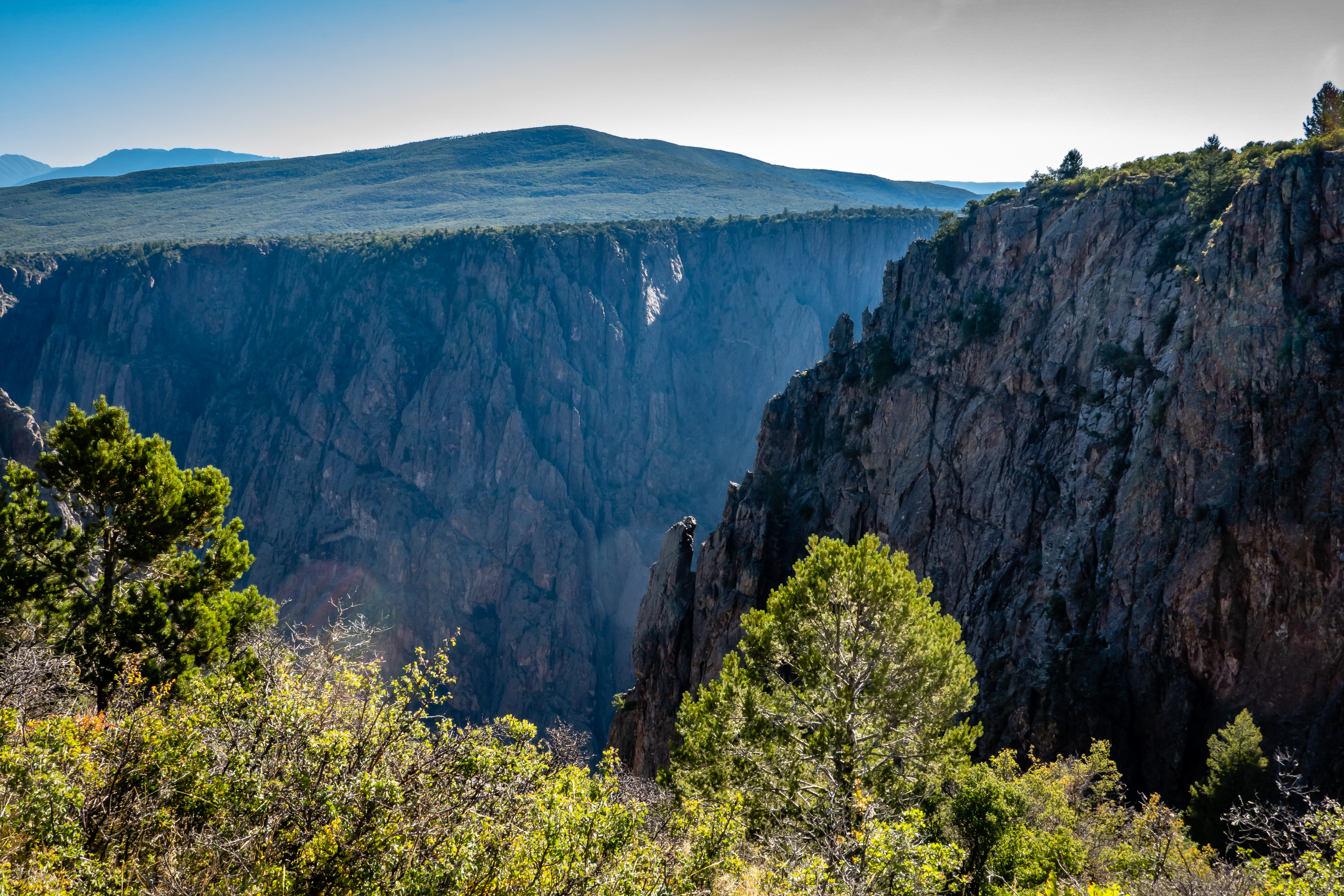
This walkway and viewing platform are out on a point jutting into the canyon. Even with the sturdy looking railing, I wasn’t 100% sure Chris would be willing to test her fear of heights. The river is about 1800 feet below the top of the canyon so one’s sense of scale is a bit overwhelmed by the magnitude of this place. She made the walk out but didn’t lean over the railing like many others were doing. The views here are simply amazing.
Gunnison River - A Mere 1800 Feet Below
There are nearly a dozen different overlooks or pullouts along the 7 mile park road on the south rim. The volunteer at the visitor center suggested the hike out to Warner Point. It might not be the first choice for visitors with only a couple of hours to spend in the park, but with our schedule, he said it was his favorite one. There are lots of parking spots at the end of the road near the Warner Point trailhead. This is also the starting point for one of the hikes down into the canyon so some of the cars might be parked for a couple days if someone is hiking down and camping near the river. We had seen a YouTube video about doing this hike. A permit is required to even attempt the hike and from what we saw, there isn’t really a set trail down. There are a few landmarks along the way that hikers should aim for but much of the hike is simply a “pick your own route” type of hike. Given the steepness of the descent and the loose rock conditions, it didn’t sound like much fun so we stick with more conventional trails. The sign at the trailhead with a motorhome hanging over the canyon seemed to be geared towards us. I’m glad we could leave our rig in the campground and sightsee with the Jeep.
Humor Geared Towards Us
Warner Point Trail follows a ridge to the west. On the south side is a large valley that must be some sort of agricultural area because it is quite green. It’s over 1500 feet below us so it’s a bit tough to determine exactly what is being grown there. There is also a large area of sand dune or badland looking terrain with nearly no vegetation. Beyond the badlands we catch glimpses of the city of Montrose. On the north side of the trail are the jagged cliffs down to the Gunnison River. We are at about 8300 feet so the air is a bit thin, but it was still a pleasant and beautiful hike.
Green Valley and Badlands
Dead Tree Still Standing
Still More Trail to Go
Just before getting to Warner Point is a side trail that heads down into the canyon. It is well signed to keep people from inadvertently taking this route. There are definitely some nice views at the point. I notice motion along the rocks and spot a small lizard. It is right on the edge of the cliff - apparently it doesn’t have a fear of heights! We were a bit surprised to find we had reasonable cell coverage at this end of the park. I guess since it is overlooking Montrose, we are within range of the towers.
Permits Required
View at Warner Point
Lizard with a View
Looking Across to North Rim
We head back to camp but make a stop at one of the many overlooks. Sunset View is first pullout on the way back. We figure we could check this one out so we will have the two westernmost ones taken care of. The views from here are also great. Since this spot looks towards the west, it’s clear where it got its name. Besides the views from the parking area, there is a overlook platform just a couple hundred feet down some steps that provides a different perspective.
Overlook Platform at Sunset View
Gunnison River
The following day, we head out of the national park to explore a small bit of Curecanti National Recreation Area. This is a very large area that borders the Gunnison River for more than 40 miles to the east of the canyon. It seems like the most highly rated hiking trails are on the north side of the river which would be a pain to get to, so we go for a simple hike along the river near the town of Cimarron which is only about a 20 mile drive from camp. The visitor center located in this town for the recreation area was already closed for the season, even though the weather has been rather pleasant. There are a few displays outside of the building that we were able to walk thru and at least read information signs about this area’s past - mining, cattle and rail travel.
At Cimarron Visitor Center
A road goes back to the Morrow Point Dam mainly for fishing access. The 468 foot tall dam was built in the 1960’s and includes hydroelectric generation. It wasn’t clear whether there are tours during the summer months or not, but it was quiet here except for a couple of guys fishing.
Morrow Point Dam
Blue Mesa Creek Trail is starts about a quarter mile downstream of the dam. The trail is less than a mile out and back. So we aren’t talking about a real serious hike. Most of the trail is on the north side of the river but a very nice pedestrian bridge gets us across without the need to wade. It is a rather rocky trail and isn’t particularly flat with lots of ups and downs to follow the terrain of the valley. It was a very pretty setting and rather quiet. The small group of guys fishing were not having any luck and were heading back out as we reached the end of the trail. There was no need for a sign designating the end because trail simply ends at the water with a nearly vertical cliff further downstream.
At the End of the Trail
Looking Back the Way We Came
Selfie Time
We head back to the car to have our lunch, then walk over to explore the old locomotive, caboose and train car. When I say explore, I really mean just look at them from a distance. The cars are on a 100 foot long section of track like a bridge just without tracks leading to or from it. I suppose that is a way to keep them from getting abuse from visitors. We did a few geocaches on the way back to the national park and took advantage of the cell coverage we happened to get along the drive. It wasn’t much of a visit to Curecanti which looks like could consume a week or more if we wanted to do some of the better hikes and sights. Maybe on some future visit?
Train Atop Bridge Section
Since the hike we did in the morning wasn’t all that challenging, we headed back to the visitor center at Black Canyon to try out the Oak Flat Loop Trail. We hadn’t bothered to research this trail except the park lists it as a 2 mile loop with 400 feet of elevation gain. We completed the loop in a counterclockwise manner which had us going down a series of switchbacks that were a bit more challenging than we were expecting. Note to self, don’t be fooled by a trail with “flat” in its name! As we proceeded down, I was wondering if it would take us down to the river but it does stop well short of that. There was a side trail that may be another route down to the river that we had seen videos of but we knew to not go that way. It was an okay trail but mostly just a hike in the woods and only occasionally getting views of the canyon.
Closer to River
After the nightly ranger talk at the amphitheater on the dark sky opportunities here at Black Canyon, we headed back over to the visitor center after sunset. My goal was to find a spot to try some night sky photography of my own. It has been some time since we have been at a place with really good dark skies and the ranger talk gave me inspiration to go out for a photo session. The only problem with this plan was the moon was at first quarter - which means one half the moon is bright. This fact meant that getting good dark skies wasn’t in the cards since I was unwilling to stay up until after 12:30 AM for it to set. So I setup on the back porch of the visitor center overlooking the canyon and let the natural light from the moon work to my advantage. It actually worked out okay, the moonlight and the few passing clouds produced a nice effect on the canyon walls. I only setup for 90 frames or just under an hour elapsed time. After seeing what I got, I wish I had done twice as many. Here is a video with the results.
Still Frame of Night Sky
Link to YouTube Video
The next morning we go for a hike right from our campsite. The Rim Rock Trail has a connector trail from the north end of the campground. This trail follows the edge of the rim and offers spectacular views of the canyon and river below. There were a few spots where Chris found herself staying well back from the edge but at no point did she feel the need to stop. I was willing to get a bit closer to the edge but even I had my limits since it’s a long way down if you go over.
Heading Towards the Rim
Tree Along Rim Rock Trail
In just over 3/4 miles we are at the visitor center. One option would be to turn around and retrace our steps. Given the views, that might be the proper choice, be we opted to continue past the building and continue over to the Uplands Trail. This will cross the park road a couple times and eventually meet up with the Rim Rock Trail and the connector back to camp. The second half of the hike was a pleasant walk through scrub brush and meadows but it wasn’t nearly as scenic as the first half. The full loop comes in at 2.2 miles door to door.
Another Overlook Area Beyond Visitor Center
A Hillside of Flowers
We had gotten an early enough start on our hike that we were able to make it to one of the more popular overlooks just beyond the visitor center - Pulpit Rock. There was a ranger talk on the geology of Black Canyon at 11 AM. We arrived before the talk started so we could check out the area first. There is a large but narrow point that juts out from the ridge of the canyon. I suppose it looks a bit like a pulpit - thus the name. We worked our way out onto the overlook and have a wonderful view of the river below. We head back towards the parking area and find the ranger getting ready at a picnic table. He had a rather decent crowd although I think most of the others just stumbled upon the talk.
Pulpit Rock
Zoomed In
Gunnison River Viewed from Pulpit Rock
Ranger Talk on Geology of the Canyon
Flower Found a Crevice to Call Home
After the talk was over, we continue out the park road to stop at all of the overlooks we had skipped on the prior day driving thru the park. Each one has a pullout for several cars and some were crowded on our first pass and we needed to stop on the return. There was no clear favorite and in many cases, the view from one overlook is quite similar to another. In fact, in several cases we can see people at the adjacent overlook since they are often only 1/4 mile away. In the order they occur after Pulpit Rock, here are some pictures from each of the overlooks along with the distance to the overlooks since most require a bit of a walk.
Cross Fissures about 1100 feet from parking.
Rugged Cliff of North Canyon Wall
Railing Better Be Secure!
Rock Point about 900 feet from parking.
Path to Rock Point
A Large Split in Canyon Wall
Devils Lookout about 1800 feet from parking.
That's a LONG Ways Down
Chasm View and Painted Wall View about 300 and 600 feet from parking.
Painted Wall
Cedar Point about 900 feet from parking.
Dragon Point about 300 feet from parking.
Gnarly Old Tree
On our last full day in Black Canyon, we do the drive down to East Portal. While technically inside of Curecanti National Recreation Area, it can only be accessed from within the national park. The East Portal Road starts just beyond the entrance station to the park. It’s less than 7 miles from the beginning to the end but there is a stretch of 3.5 miles where it drops 2000 feet for an average grade of 11%. It’s a rather curvy road with plenty of switchbacks. The good news is it is all paved so it’s not like there are ruts and gravel to contend with. The bad news is our Jeep is showing signs of needing a brake job so I knew I needed to be extra careful on the descent. I pull over at a large gravel area off of one of the hairpin curves to check the brakes and get a view of the valley below.
View On Way to East Portal
We make it to the bottom without incident and park to check out the river. The town that used to be here was only present to build the Gunnison Tunnel back in the 1905 timeframe. The area around the town of Montrose is rather arid so a plan was developed to blast a tunnel through the mesa that separates the Gunnison River from town so water from the river could be diverted to town for irrigation. That would explain the green valley we saw from the Warner Point Trail a few days ago. The tunnel is just under 6 miles long and drops 40 feet over that length. It has a cross section of 11 by 12 feet which equates to a staggering 4 million cubic feet of rock! A small dam was built across the river to ensure the water can be diverted into the tunnel. I’m always impressed with what could be accomplished back before all the high tech gizmos and machinery we have available today.
Barrier to Keep Debris and Kayakers from Tunnel
Tunnel is Near Small Building on Left
Downstream of the tunnel is the East Portal Campground. Most of the campers were in tents but a few class B vans or truck campers had made the trek down to a rather pleasant looking campground. Just beyond the camp is the East Portal Trail. It is listed as 0.8 miles out and back. It turns out to be less of a trail and more of a path for some of the many people out fishing in the river. The terrain is rather rocky at points and a bit of a challenge for us. The people fishing have waders on and when the terrain is difficult they simply walk thru the water. We don’t go quite as far at our map shows we can, but it’s clear the views aren’t going to change much in another few hundred feet.
View on East Portal Trail
Diversion Dam for Tunnel
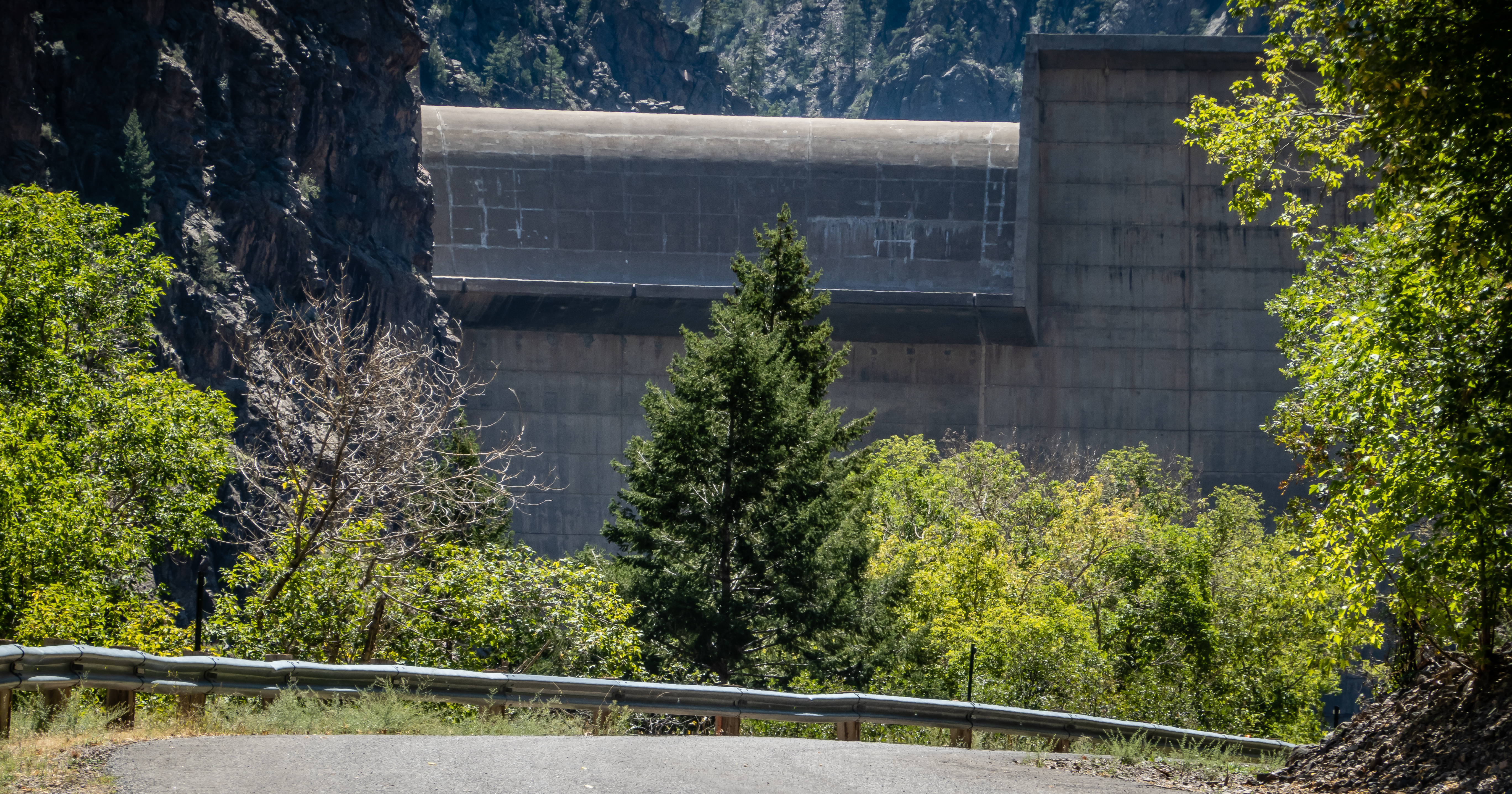
Back at the car, we drive the road upstream as far as it goes. A gate stops us just short of the Crystal Dam. We can get a glimpse of the dam thru the fence and there is an information sign about the dam but we are nearly 1/3 mile from the dam at this point so it’s tough to get a sense for the size. It’s a relatively new dam built in the mid 1970’s for hydroelectric power. We stop at a pullout with picnic tables to eat our lunch with a view of the river below. This was a fun stop and worth the extra wear on the brake pads to get here.
A Glimpse of Crystal Dam
Back at camp, we have dinner and then head to the visitor center to check out sunset. Our timing wasn’t great so driving the extra distance to Sunset View wasn’t going to be worth the effort. Black Canyon of the Gunnison turned out to be a real fun stop for us. The canyon is quite impressive and while we could have gotten a sense of things if we had simply made this a day trip out of Montrose, I’m glad we scheduled five nights here so we could be more leisurely about our visit. Plus this got us thru the Labor Day weekend so maybe the camping crowds will start to thin out. Next stop Ridgway Colorado - yes that is spelled without the “e”.


No comments:
Post a Comment