Map of this blog's locations click this link to open the map
It’s hard to believe we have spent over 4 months so far in Colorado and are moving onto our final stop in Fruita for a 13 night stay. It’s just over a 90 mile drive from Ridgway to our sixth Colorado state park. James Robb Colorado River State Park Fruita Section is quite the mouthful. This state park is divided into 5 distinct sections that are located over a 30 mile span of the river. Two of the sections have camping facilities so it’s important to pick the one you want. We picked the westernmost one in Fruita because it is just a few miles from the entrance to Colorado National Monument. It was a fairly uneventful drive with the scenery along the way looking more like Utah and less like the Colorado views we have become accustomed to. It was a nice campground that included a covered shelter for the picnic table. We are definitely getting used to the full hookup state parks here in Colorado. Since we got in early enough in the afternoon, I headed into Grand Junction for a quick oil change. Of course they discovered that my brakes were in need of work so I had them order the required parts with the plan of getting them taken care of during our stay.
On our first full day, we head into Colorado National Monument (CNM). The 23 mile long Rim Rock Drive runs through the monument from Fruita in the northwest to Grand Junction in the southeast. Over the course of that distance, it gains 2000 feet in elevation over the valley below. There are about 18 pullouts or overlooks along the way that offer commanding views of the valley or the impressive canyons and rock formations in the heart of the monument. To gain that much elevation, the drive has numerous switchbacks and a couple of tunnels. We take our time and stop at most of the stops in the first 4.5 miles before the visitor center. Balanced Rock View is aptly named as the huge rock appears precariously positioned atop the large spire.
 |
| Entrance to Colorado National Monument |
 |
| Heading Up from Fruita Entrance |
 |
| Overlooking Canyon |
 |
| Distant View Overlook |
 |
| Some of Rim Rock Drive Below |
 |
| Huge Balanced Rock |
We stop at the visitor center to check out the displays, pick up some literature and watch the short video about the park. Given its proximity to Interstate 70, I suspect that most visitors will simply exit the expressway, drive thru the park, hop back on I-70 and continue on their travels. In that regard, this national monument is ideal for the casual drive by visitor. When we tell the staff in the visitor center we are in the area for nearly 2 weeks, they have all sorts of recommendations for hikes that most visitors won’t get the chance to experience.
 |
| CNM Visitor Center |
The Canyon Rim Trail starts out of the visitor center and since it is only a 1 mile out and back hike, even lots of the drive by visitors will check out at least part of the hike. The views of the canyon below are outstanding along this trail. It helps that we are over 600 feet above the floor of the canyon. We get good views of one of the more famous spires in the monument - the 450 foot tall Independence Monument. Even the views of the mountains to the north of Grand Valley are impressive. |
| View Over Canyon |
 |
| Steep Drop Off |
 |
| View of Fruita Valley and Mesa to the North |
 |
| Even Steeper Drop Off |
Canyon Rim Trail is a bit hard to follow since there are so many optional spurs to get close to the edge for better views. But it’s not like people would get too lost since it is bounded by the sheer drop off to the south and the campground to the north. At the end of the trail is Window Rock. This is one place where there is a sturdy railing to keep visitors from leaning too far over the edge to try to see the window in the rock. The angles are such that while you can see the window in person, it’s hard to get a good photo that makes it clear what you’re looking at. (We will do a hike in the valley below in a couple of days that provides a much better view.) |
| Overlooking Wedding Canyon |
 |
| Window Rock Barely Visible |
 |
| Independence Monument |
 |
| Small Pools |
 |
| Chris Finds Her Own Window |
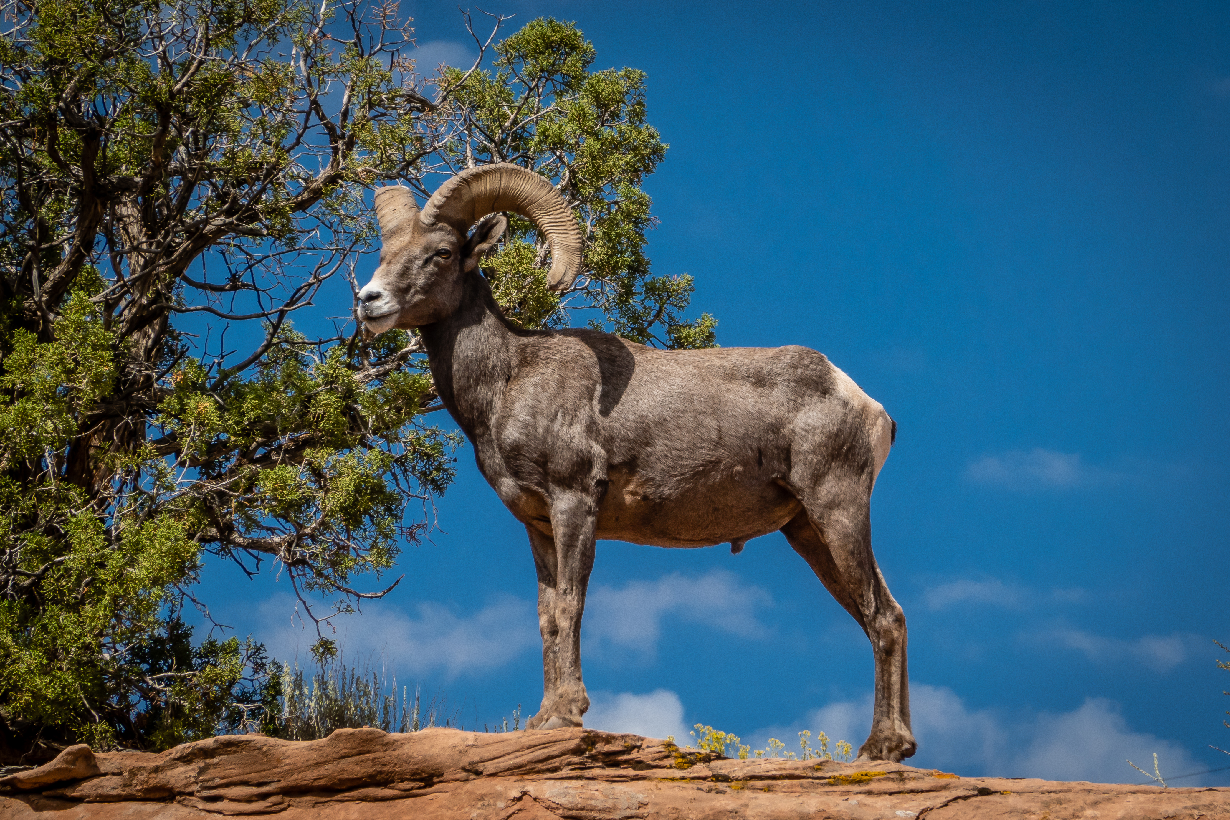
Originally we planned on taking the trail into the campground area and working our way back to the visitor center but decided the views along Canyon Rim were just too beautiful. So when we got to the large covered shelter overlooking the canyon, we turned around and retraced our steps. It turns out, this was a good choice because on the way back we spotted two bighorn sheep - a ram and ewe. They were on a bit of a rock ledge 10 feet above us but only 30 feet or so from the trail. They were definitely aware of the crowd that was forming to watch them but were not all that influenced by our presence. They moved around a bit as they slowly worked their way back in the general direction of the visitor center. What was slightly amusing was the ranger had told us that at this point of the year, the bighorn were deep in the canyons well away from the crowds. Glad he was wrong. We watched them for nearly 15 minutes before they wandered well away from the trail. Here are a few of my favorite shots of the many I took. |
| Male Bighorn Sheep Poses |
 |
| You Looking at Me? |
 |
| Ewe Looking at Me! |
 |
| Ram with a Great Background |
 |
| Ram Gets Tired of Posing |
We got back in the car and continued into the park stopping at each of the overlook parking areas. The first one was Independence Monument View. We grabbed our sandwiches and sat at the bench enjoying the view. While we were eating, a group of 3 bicyclists stopped for a rest. We chatted with them and they were doing a loop that includes the 23 miles thru the park as well as 20 miles of flatter roads down below to complete the loop. Even in our prime 30 years ago, this would be one heck of a challenge to complete on bike. |
| Another Look at Independence Monument |
Next memorable stop was Coke Ovens Overlook. This is a line of pillars that have a cone shaped sandstone. Personally, I think they look more like bee hive shape. |
| Coke Ovens Lined Up |
Our next stop is at the Upper Monument Canyon Trailhead parking lot. This is one starting point for the 11 mile out and back Upper Monument Canyon Trail. We are not looking to do this serious of a hike but the 1 mile hike to Coke Ovens Viewpoint begins by following this trail before splitting off after a tenth mile or so. The split in the trail is well marked so it’s easy to keep on the desired route. After the initial 100 foot drop in elevation, our trail levels out a bit. It is along the side of the canyon wall with some serious steep drop offs to our left. But they must not have been too intimidating since I didn’t hear any whimpering from Chris. |
| Heading Out to Coke Ovens |
 |
| Future Arch? |
 |
| Canyon View |
The whole feel of the place is different when you’re on a trail like this as opposed to simply looking out from an overlook. We make it over to the Coke Ovens Viewpoint which has a railing all around to keep people safe and remind thrill seekers to stay behind the railing. In one sense the views of the pillars isn’t quite as good here. Possibly since we are almost too close. We enjoy the views of the canyon from here before heading back to the car. This was definitely a beautiful albeit short hike. |
| Closeup View of Coke Ovens |
 |
| Another Angle of Coke Ovens |
The next stop is Artists Point with yet more incredible views. It’s at this stop that we realize it’s almost 3 PM and we aren’t even 9 miles into the 23 mile drive. If we hope to get home before dark, we will need to pick up the pace and skip a few overlooks.
We had heard that Upper Ute Canyon Overlook was a good stop, so we headed there. A short trail from the parking area brings us out to a point overlooking the canyon below. The sandstone cliff on the opposite side is almost perfectly smooth and vertical. But it has a bit of curvature to it so that shouting something like “hello” produces an echo about a second later. It was well worth the stop and the short walk. |
| View at Upper Ute Canyon |
 |
| Echo Wall |
We continue on the drive skipping a couple more overlooks. Our last stop will be at Cold Shivers Point. This stop is partway down the road but before we get to the ten or so hairpin curves. The canyon seems to be a bit narrower at this point along the drive but still quite pretty. The rest of the drive down to the Grand Junction entrance was just a little bit more nerve wracking since I now knew for sure the Jeep needed a brake job but I was still waiting for parts to arrive. |
| View at Cold Shivers |
Now that we have gotten a good sense of Colorado National Monument, we head back the next morning to do a proper hike. The ranger at the visitor center had highlighted a few of the hikes in the park that are good for visitors that have more than just a few hours to visit the park. He had suggested Monument Canyon Trail. But instead of doing the full 11 mile out and back hike which goes between Rim Rock Drive and the eastern edge of the park, we could start from the eastern trailhead and take the trail up to Independence Monument and back. This ~5 mile section of the hike was pretty and the easier portion of the longer hike. When we investigated the trail in AllTrails, we discovered there was a way to turn this hike into a loop instead of doing it as an out and back. The caveat was that half of the loop was on the unimproved Wedding Canyon Trail. |
| Monument Canyon Trailhead |

There were a large number of cars parked at the trailhead but we found a legal spot and headed out. After several hundred feet, there will be the split in the trail. Many loop trails we have hiked, it doesn’t matter which direction you tackle the loop. This is definitely not one of them. Take the loop in a counterclockwise direction by heading to the right up the unimproved Wedding Canyon Trail first. Why is it so important for this trail? After the first 1.1 mile of fairly flat hiking, we come around the backside of the hill we are walking around and are faced with a 0.4 mile section with an elevation gain of 460 feet for an average 22% grade. Since this is an unimproved trail, there are no strategically placed rocks acting as steps. It isn’t a complete free for all as the trail is marked and rather obvious, it’s just the footing is not so great and it’s steep. Had we gone the opposite direction, coming down this section of the trail with the loose rocky surface would have been a real challenge. The other saving grace is we are in the shadow of the hill (at least in the morning) so it’s isn’t quite so hot coming up. The views along this part of the hike are very nice especially with the sun lighting up the opposite side of Wedding Canyon. |
| Heading Out Wedding Canyon Trail |
 |
| Odd Rock Formation |
 |
| Looking Back Down Gnarly Section of Trail |
The next 3/4 mile of the trail is still heading up but at a much more gradual rate. We can start to get a glimpse of Independence Monument which will be our halfway point. It also turns out that on the opposite side of this canyon is where Rim Rock Drive and the visitor center are. We can catch glimpses of the various overlooks that we had visited just 24 hours earlier. It was from this direction that we get a much better view of Window Rock. It’s funny how even though we are nearly a half mile away compared to the 100 feet from yesterday, the window is much more visible. |
| Approaching Independence Monument |
 |
| Better View of Window Rock from Across Canyon |
As we get closer to Independence Monument, I start to notice something about halfway up the spire that looks out of place - something brightly colored. At first it wasn’t clear what I was seeing but when I noticed it moving, I zoomed in with my camera and realized there were two rock climbers heading up. I knew climbing was permitted but didn’t really expect to see someone doing it. |
| Two Climbers Halfway Up Independence Monument |
As we come around to the intersection with Monument Canyon Trail, there are many more people. We only saw a couple of people on the hike up, so I guess these people either started where we did and came up the trail we are planning to head down, or had made the long descent from Rim Rock Drive. One group asked us about the hike along Wedding Canyon as they were planning on taking this route back. We warned them about the trail conditions and how steep the one portion is, but they headed that direction anyways. The views from this intersecting point were pretty remarkable with many more spires and hoodoos to look at. We had a snack before heading back down. |
| More Views in the Canyon |
 |
| Steep Rock |
Most of the rocks in the park are the reddish sandstone but along this part of the trail, there are large numbers of huge black boulders - presumably from some ancient volcano? The trail headed right next to a boulder that was shaped almost like a perfect cube with 8 foot sides. The kid in me wanted to carve “pips” on the faces to turn it into the world’s heaviest die! We are able to see some of the homes in the valley as we continue down the trail. |
| Black Lava Rock |
 |
| Massive Die Along Trail? |
 |
| View of Grand Valley |
This section of the hike follows along the same hill we have been hiking around but this side has a nearly vertical face with the top being nearly 400 feet over our heads. It was definitely a beautiful hike. A bit further down the trail were some more rock climbers. They were trying a rock face that wasn’t quite vertical but much steeper than we could imagine. The last half mile of the trail is mostly flat but goes right along a tall fence and what are likely some rather expensive homes. This was definitely a great hike. |
| Trailside Humor |
 |
| Rock Climber |
A weather front was going to be moving thru the area for the next several days with rain expected to be on an off but this worked out okay. It gave us a chance to recuperate from our hike, drive to a nearby county to get a geocache and get the brakes on the Jeep serviced. We even managed to get in another short hike at a place called Dinosaur Hill. |
| Dinosaur Hill |
We have driven past this place a couple times on our way to the national monument since it is only a mile or so south of camp. There is a 1 mile loop trail that gives a nice view of the rodeo grounds and Colorado River. It’s name comes from the fact that in 1901, a paleontologist dug into this hill and found a nearly complete brontosaurus. Over the next several years, the bones were removed and are now on display in Chicago. There really isn’t a lot to see here except for the opening into the side of the hill where the excavation took place. I wouldn’t consider this a “must do” stop but since we had some time before another line of showers moved in and it’s so close, we felt we had to check it out. |
| Rodeo Grounds |
 |
| Colorado River |
 |
| Approaching Dinosaur Dig Site |
 |
| Gated Entrance to Dig Site |


No comments:
Post a Comment