Map of this blog's locations click this link to open the map
After our monthlong stay in Boulder City, our next reservation was at the Lake Havasu City Elks Lodge but not until January 1st. That left us 19 nights of unplanned travel for the last part of December. We knew there were a couple of options at either the Needles California Elks Lodge or a state recreation area in Laughlin Nevada, neither of which take reservations so we had originally planned to try these out. But about two weeks ago, I had the idea to see if we could get into Death Valley NP. My real goal was to get there for a few days simply to be able to “check it off the list”.
There are several campgrounds in the Furnace Creek area with many dry camping sites but only 18 of the campsites sites have any utilities - surprisingly these are full hookup! When I have looked for openings in the past, I never found one of the full hookup sites available for more than a night. The reservation system for these campgrounds is on a 6 month rolling window, so if you want to get one of these sites, it looks like we would have needed to plan well in advance. But I had found one dry campsite in the Furnace Creek Campground with availability for 4 night in a row, if we head out of Boulder City a couple days before we need to. We had decided that 4 days would be more than adequate to see this remote and desolate park and we wouldn’t have any problems dry camping for such a short period of time. So we had reserved our spot and planned to spend the 4 nights there and then move on to the spots in Needles or Laughlin.
It’s not quite 170 miles from Boulder City to Furnace Creek but once past the greater Las Vegas area, things get desolate pretty quickly. We stop at a small rest area in Amargosa Valley on our way in to have lunch and look for a nearby geocache. The last 20 miles of the drive is all downhill. It drops over 3200 feet in that short of distance. I suppose it will go without saying, but this spot will be the lowest elevation we shall ever camp at. Since the park has the lowest elevation below sea level in North America and our camping spot itself is at -200 feet below sea level, it would take some doing to get to a lower place.
 |
| How Low Can You Go? |
We get into our campsite and setup for the 4 nights. Unfortunately, I end up getting somewhat sick that first night. I was having equilibrium issues and felt quite dizzy. Maybe the low elevation had messed with my ears. But we didn’t get much accomplished that next day as I tried to get back to normal. We were somewhat surprised that there was fairly decent cell coverage at camp. We were expecting to have the dreaded “no service” message during our stay here. This allowed us to watch a few more YouTube videos about what there is to see here. Chris also picked up literature from the nearby visitor center and we formulated a plan.
Just over four months ago, Death Valley had been hit with a devastating flooding event. On August 5, it received 1.7 inches of rain. That might not sound like a lot, but the average annual rainfall in the park is just 2.2 inches. There was significant damage to roads and other infrastructure. The crew did a good job in clearing the debris from most of the roads, but there is still a portion of the northern side of this huge national park that is closed while roads are rebuilt. This meant some of the cool things we had hoped to see wouldn’t be available during this visit. The Racetrack and Ubehebe Crater being two of those sites.
After evaluating what there is to do in Death Valley, we realized there was more here than we thought. I also had been keeping our eye on the campsite availability and discovered that there must have been a cancellation at one of the full hookup sites. Chris walked over to the entrance station and was able to convert our 2 remaining days of dry camping into 3 nights of full hookups. Surprisingly they even credited us for the 2 nights remaining so it wasn’t too expensive to do so. It did mean that we needed to pack up everything to move the few hundred feet between the sites. We conclude it was worth is since the weather had actually been rather cold over night and having 50 amp power would make us more comfortable. Since the site we were moving to was vacant, we were able to get this move done early in the morning to not interfere with our plans.
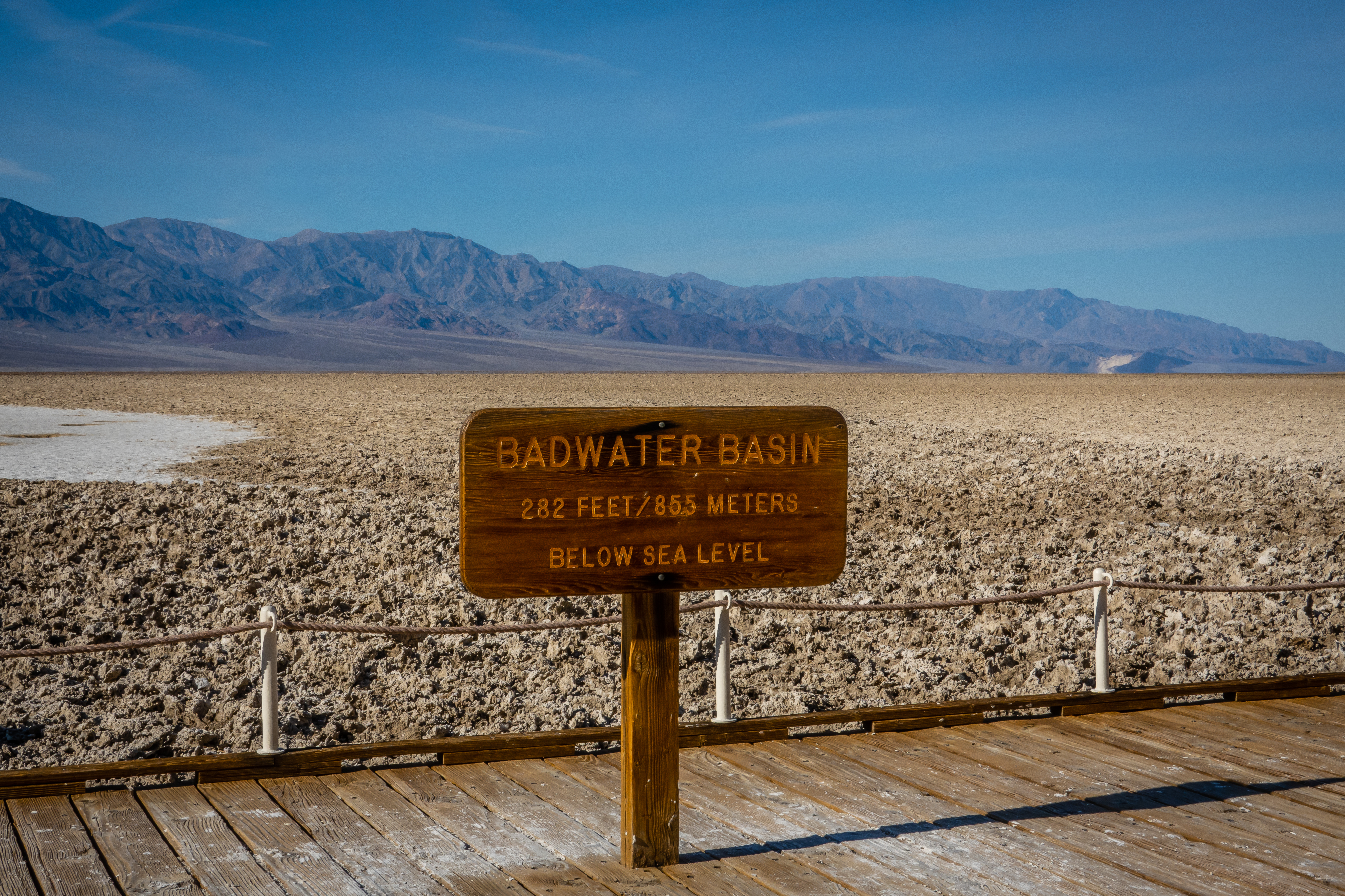
We planned to take it relatively easy while I assess my condition before doing any strenuous hikes. Out first stop is to drive to Badwater Basin. This is one of the more popular destinations within the park. There is parking for several dozen cars and even a few spots for tour buses or RVs. It’s a short walk to small boardwalk area with information signs. At 282 feet below sea level, this is the lowest point in North America. One of the signs mentions a plaque on the cliff behind us which shows where sea level actually is. I doubt I would have even noticed the white sign that far above us. I needed two pictures to be able to actually read the sign and composite them together. |
| Lowest Point in North America |
 |
| Looking Out Over Badwater Basin |
 |
| Sea Level Sign on Cliff |
There actually is a small pool of water here. A small, rather rare snail calls this place home, so we aren’t allowed to confirm the water is bad. There is however a well worn path out into the basin. It’s about 1/3 of a mile out to a large expanse of white. We decide it’s worth the time to go check it out close up and in person. The ground is quite different as we make our way out. There are strange ridges of minerals that get pushed up between relatively flat sections. Most of the initial section is a brown color with small dusting of white salt crystals. As we make it to the all white area, there are similar ridges and flats but the whole area is covered in salt. The area is in a constant state of change as the winds and rains cause the shapes to come and go. It is a rather surreal place. |
| Path Out Into Basin |
 |
| Ridges |
 |
| Salt Deposits |
We had planned the day to start at Badwater Basin in the south and then slowly work our way back north stopping at various other destinations along the way. Death Valley sits between two mountain ranges - the Panamint Range to the west and the Amargosa Range to the east. Most of the hikes in the area seem to follow canyons into the sides of these mountains. Natural Bridge is the next stop. It’s a 1.5 mile drive on a bumpy dirt road but should be passable to most cars. There is room for maybe a dozen cars here and it wasn’t too crowded when we arrived. The trail starts out up a wash toward the canyon and there are some beautiful views along the way. |
| Starting Out on Natural Bridge Trail |
 |
| Erosion Channels |
 |
| Canyon Narrows Down |
The feature this hike is named for is just under a half mile up the canyon. The terrain is a bit rocky but relatively easy. There are all sorts of dry waterfalls along the sides of the canyon, but the bridge that remains connecting the two sides is impressive. It’s probably about 35 feet up to the bottom of the bridge which is maybe 25 feet thick. As we pass under it, we see some cracks in the rock which makes us wonder how long it will withstand Mother Nature. |
| Approaching Arch |
 |
| Chris Poses for Scale |
 |
| Opposite Side of Bridge |
The canyon and wash continue past the bridge for another 1/3 mile or so before running into a large dry waterfall. I made it halfway up before realizing the remaining portion was going to be tough to climb and worse to come back down. This is where the trail is listed as ending, so we don’t push our luck. |
| Continuing Up Canyon |
 |
| Dry Waterfalls Blocks Path |
 |
| View from Partway Up |
Two miles up the road is a left hand turn into an area called the Devils Golf Course. Another mile long bumpy dirt road gets us to the small parking area. There really isn’t a hike that starts from here and how far out you choose to walk will depend on how willing you are to get injured. |
| Looking Over Devils Golf Course Towards Mountains |
 |
| Chris Swings Her Imaginary Golf Club |
Even though it’s just 2.5 miles from Badwater Basin, the terrain here is much different. Since this area is a bit higher in elevation, it doesn’t get flooded as frequently as the basin does. So the minerals that get pushed up from the ground just keep growing and make the highly irregular shapes which can be a challenge to walk thru. Even though the ground looks fragile, it is actually rather hard and the salts tend to form sharp little peaks all along the tops of the formations. I didn’t go more than 10 feet out for pictures and when I accidentally placed my hand on the ground to balance myself, I discovered just how sharp they are! This isn’t more than a 10 to 15 minute stop but is worth a visit.
 |
| A Closer Look |
 |
| Notice Razor Sharp Salt Crystal Ridges |
 |
| Mountains on Other Side of Valley |
Our last stop of the day is actual a scenic drive that will have several stops along the way. Artists Drive is listed as the second “must-see” location in the park. It’s a 9 mile one way drive through some incredible views. This is a paved road but is closed to vehicles over 25 feet, so plan accordingly. About 1.5 miles into the drive is a pullout for 10 cars. There is a quarter mile path out to a small hill which provides for some excellent views of the area. |
| Cairn Artwork |
 |
| Path Up the Hill |
 |
| Great View |
As we continue the drive, we find places worth pulling over simply to get a picture and see things more than possible when driving. There are occasional smaller pullouts to allow these stops. |
| Colorful |
 |
| Looking Back Over Basin |
Just over 4 miles into the drive is a right hand turn to a place called Artists Palette. It was getting close to sunset, so the colors were pretty astounding but we were also quickly losing that light. |
| Overlooking Artists Palette |
We worked our way out into the many paths that seem to head up small canyons or go across a small ridge line. It was a rather magical place made better by our late afternoon arrival. It was getting dark by the time we made it back to camp after experiencing a rather full day of sightseeing. |
| Colorful Hills and My Shadow |
 |
| Lots of Colors |
 |
| More Shadows Forming |
The following day would lead us a bit further from camp. Mosaic Canyon is a 4 mile out and back hike not far from Stovepipe Wells. It’s about a 26 mile drive on the main park road before turning onto the 2.5 mile bumpy gravel road which most vehicles will be able to handle. The parking area was pretty crowded when we arrived, so we wouldn’t be the only ones out exploring. The trail starts out on the wash but it narrows down rather quickly to be a canyon hike as opposed to a wash hike.
 |
| Looking Back Down the Wash Towards the Valley |
 |
| Heading into the Canyon |
This canyon is quite different than yesterday’s hike. The walls here are predominantly made of two very different types of rock. There are places where all the rock is a highly polished marble. The smoothness of this is amazing - water and time hard at work. But then there are other areas where the rock is something known as breccia. This rock was created from remnants of a shattered landslide that filled the area. Over time dissolved calcium carbonate cemented all the shards together and then was subsequently carved out by water as this canyon was formed. Its from this rock the canyon gets its name. The other odd thing with this breccia, it looks like it would be rather fragile and easily broken apart, but it is as solid as the marble.
 |
| Beautiful Marble Wall |
 |
| Marble with Globs of Breccia on Right |
 |
| Mosaic Look of Breccia |
Much of this canyon is fairly narrow and both of the sidewalls can be reached in my wingspan. There are a few short dry waterfalls to climb up and some of them are so smooth of a surface that it’s tough to get enough traction to continue on. It was truly an incredible hike. We did get to one large jumble of rocks that weren’t going to be easy to get up and over. We waited to watch one couple come down to determine what the proper approach might be. With my long legs, I was able to climb up the rocks, but Chris was not able to make it. I told her I would go a bit farther before coming back and left her to wait.
 |
| Looking Down a Narrow Smooth Section |
 |
| Canyon Widens at a Bend ... |
 |
| ... But Narrows Back Down |
 |
| Large Rock Obstacle Stops Chris |
As I continued up the canyon, I ran into another dry waterfall that was about 4 to 5 feet tall. It had a very polished surface with no real hand holds or foot holds. I attempted to climb up this a few times but came up short each time. I really didn’t want to have this be my stopping point. Then I realized that if I were heading down canyon, I would simply sit and slide down. With that in mind, I backed into the falls and was able to use both hands and feet to slide up the falls. It wasn’t the most graceful move I’ve made but nobody was around to see me.
 |
| Another Smooth Falls the Almost Stopped Me |
A short distance later was an even taller dry falls. There was a very smooth center portion, but since this one was much wider, I had more options to pick a route with places to hold onto.
 |
| A Wider Falls |
I wasn’t sure how long I could keep going without Chris either worrying or getting bored while she waited. I decided to go a few minutes more since this canyon was so neat. The next obstacle was more than most people could handle unless they happen to be a rock climber. But two large arrows made out of stones made it obvious to get out of the wash and climb around. I first went the 50 feet or so to see what was being bypassed and it was clear it required the alternate route around. At least the canyon was wide enough here to even make this an option.
 |
| Just Follow the Arrows Out of Main Wash |
 |
| The Large Obstacle that Needed a Bypass Route |
Once through the detour, the canyon opened up dramatically and looked to be an easy walk at least for as far as I could see, but I had reached the time limit I had in my head and turned back to retrace my steps. There are definitely some very cool patterns in the rock walls that make me wonder how the heck they were formed. At the one slide I had backed into, the view down gives a different perspective on the problem. I was able to slide down but there was a short distance of free fall that had to occur since even my legs weren’t able to span the drop.
 |
| More Cool Rock Patterns |
 |
| Looking Down Smooth Falls from Earlier |
I made it back and found Chris had moved a bit to find some sunshine. We had a little lunch before we headed back out. This was by far one of the better hikes we have done in some time. I’m not positive how much of the trail I did. Possibly 1.5 miles out so there wasn’t really much more to do although who knows how many obstacles I may have encountered along the way.
 |
| Emigrant Rest Area Building |
 |
| Wild Burro Along Road |
The last 2 miles of the road are dirt but in fairly good condition and fairly wide. We had seen snow in the distance along the drive but hadn't really thought through our decision to head here so we weren't really prepared for what we ran into. I was watching the outside temperature drop on the car's thermometer and it went from 50's to 40's and into the 30's. With just a quarter mile to go, the dirt road was now a snow and ice covered road. We managed to make it into the parking lot but was glad there weren't other drivers coming back down. It turns out the charcoal kilns are at an elevation of 6935 feet! It was a balmy 34 degrees as we parked the car. What's weird is they are pretty much in line with Badwater Basin on the other side of the Panamint Mountain Range. Without really trying, we had covered a 7000 foot elevation range in our drive today.
 |
| Snow Cover Mountains in the Distance Along the Drive |
We didn't have much extra clothing with us, but we put on as many layers as we could and headed out. The ground was extremely slick. I suspect the snow partially melted and then froze over into ice. I was convinced we were going to fall on our butts. I wasn't perfectly sure the Jeep wasn't going to slide sideways down the sloped parking lot. These ten beehive-shaped kilns were built in 1876 making them nearly 150 years old. They are all open and in excellent condition. Even though it was just a little after 3 PM, the sun was already setting behind the mountains to the west so it was only going to get colder and the lighting for pictures wasn't very good. Hint to others - come earlier in the day and pick a warmer day.
 |
| Charcoal Kilns |
Each kiln has a door on the front side and a large window midway up on the back side. In use, they were filled with pine logs and were fired for about a week which reduced them to charcoal which was then hauled to the smelting facility at the mine 20 miles away. It was really neat to see these and learn how they were used. Inside, there was still a faint smell of creosote from burning the soft pine.
 |
| Backside of Kilns with Window for Chimney |
 |
| Incredible Stonework |
 |
| Pretty View from Site of Kilns |
We didn't spend much time here simply because it was so cold. There is a hiking trail that starts from here. On a hot day in Death Valley, a hike at elevation in the pine forests might be nice, but not today. We hustled back into the warmth of the car and turned on the heated seats and steering wheel. As I started to back up to leave, a van was trying to come up the last part of the road to get to a parking spot. He was spinning his tires and sliding side to side. I paused and waited for him to get stationary before we passed by him. Once we got out of the snow and ice, the drive was fine. We stopped at a couple of places to check out the incredible views. We didn't run into out wild burros on the return drive.
 |
| The Hills Have Wrinkles |
We planned to simply drive back to camp but as we came by the Mesquite Flat Sand Dunes, we decided it was back to a reasonable temperature and the sun was just starting to set in the valley making the views here rather dramatic.
 |
| Sand Dunes |
We only walked out into the dunes a few hundred feet since we had a very long day already. We aimed for areas that hadn't been trampled by people so the ripples in the sand were as the wind had created them. The wide variety of patterns and the long shadows were incredibly pretty. A very nice way to cap off our day.


No comments:
Post a Comment