June 29, 2025 marks our ninth year of traveling across this wonderful country in our motorhome as full time travelers. The journey continues to be mostly fun and exciting although we still need to try to remember to not treat our lifestyle as a vacation. Generally, vacations are to a new area for a limited time period, and the urge is to try to squeeze in as many activities and sightseeing destinations as possible. So when we pull into a campsite in a new location for a week, the inclination might be to do a search for the top 10 things to do in that town and fit them all in. Since we are big into hiking, we often use AllTrails, or similar sources, to seek out the best hikes and work those into the plans as well. But our experience has been that maintaining “vacation” pace can work for a few weeks but it is next to impossible to maintain for 52 weeks a year.
We stayed well east of the Mississippi River this past year. The map below shows our route. (Clicking on the link below the map will open up the Google Map I created for the year and permit you to zoom and scroll to better see the route.) Sort of looks like a poorly drawn letter “Y”. I doubt we will ever choose our route with the intention of creating some interesting artwork, but who knows? We camped at 40 different campgrounds, Elks Lodges or parking lots over the past year. Several of the stops where at places we have visited before with the longest stop (175 nights) being at The Great Outdoors in Titusville Florida - but since we now own an RV lot in this resort, it will likely be a common destination over the winter months. Other repeat stops were simply because they are convenient overnight stops along a route we frequently travel.

Thirty-one of the stops were at places we have not stayed at previously. In all honesty, it’s the opportunity to see a new place that motivates us to continue the travels. We started out year 9 just a few weeks into our 2024 summer plans of visiting the New England area. Exploring the Green Mountains of Vermont, the White Mountains of New Hampshire and portions of interior Maine were quite enjoyable. The three months seemed to go by quickly.
Another month was spent heading south. We should have budgeted more than 8 nights in the Boston and Cape Cod area of Massachusetts but now we know of some decent Elks Lodges in that area to return if we want to explore more. Even some of the simple overnight stops provided for unique experiences. Frackville Pennsylvania was a nice location to get a free tour of the oldest brewery in the country - Yuengling. Even the small town of Wilson North Carolina had some of the most incredible whirligigs we have ever seen.
After our extended stay in Florida for winter, we opted to head through northern Georgia for some excellent hiking before a long stop in Cincinnati to visit with family and then up through Indiana and into Michigan where we end year nine participating in a Habitat for Humanity build in Marquette on the Upper Peninsula. It has been a full year!
Another style of map I create from all of our stops are “heat maps”. The first one shows all the states we have camped in over the past year. The darker shade of red indicates more nights while light red means we stayed fewer nights. We managed to camp in 18 different states. The second map shows a similar idea but includes all 9 years of our travels. With our stop in Rhode Island, we are now up to 45 states. Since our USA map is nearly completely filled in, I am including one more heat map that is divided down to the county level. We have bumped up our number of counties by 24 over this past year for a total of 295.
 |
| Heat Map of Year #9 |
 |
| Heat Map of First 9 Years of Fulltime |
 |
| Same as Above but Broken Down to County Level |
Like a good engineer, I have all sort of data that I keep track of from our travels. I don’t bother to include expenses that we would have if we were living a conventional life in a sticks and bricks house like groceries, dining out or sightseeing costs. But items related to a nomadic lifestyle are included. I have limited the table to just this year and the 5 most recent years to make the chart readable. Prior years data can be found in similar posts I have done at the end of June each year.
 |
| Condensed Stats for Last 6 Years |
There really isn’t a lot of unexpected findings within the data. We drove the motorhome slightly more than last year but pretty much in line with our typical amount from prior years. Since we tend to enjoy staying at state parks, it was nice to be able to improve on our number of nights spent at them. One thing worth noting about our stays at private RV parks, when we purchased our lot at The Great Outdoors, we knew what the quarterly HOA fees and annual property taxes would be and they had provided what sort of rental income we could expect for our lot if we are not staying there for various times of the year. Now that we have gone through a year of lot ownership, it turns out that our lot ended up costing us just under $23 per night (including electric) for the 175 nights we stayed there. That’s not bad for a place that has excellent facilities and charges $110 a night for visitors.
For the past few years, I have used our yearly reviews to highlight some excellent hikes or bike rides we have found over the past 12 months. (Our calendar year end reviews highlight our top places we stayed at if exploring by foot or bike aren’t your thing.) We managed to get in roughly 75 hikes over year #9. Chris and I looked over them all, remembering nearly all of them and each voted for our favorites. This year we came up with 8 of them that we feel deserve to be on our list. For each one, I’ll give an overview of the trail, a picture from it and a link to the blog post that fully describes the outing to better show why it made it to the list. In chronological order, here are our top 8 hikes/rides.
- Avalanche Lake Trail - Lake Placid NY
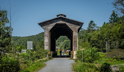
We tackled several nice hikes in the Adirondacks during the two weeks we spent in the area but Avalanche Lake Trail stood out with both its beauty and challenging terrain. There are a few starting points to get to the lake. We picked the one from the Adirondack Loj since it sounded to be the least flooded option during our stay. What started as a nice hike in the woods became steep around the 2.5 mile point as we climb over Avalanche Pass before heading down to the pretty mountain lake. You’ll want to continue along the challenging rock climb along the edge of the lake. There are assorted ladders and stairs in place to scale the larger ones. But the real draw for us was to check out the cantilevered platforms that are in place to get around the sections with only a shear rock face along the lake. Read the blog post, to discover the story behind their name - Hitch-Up Matilda’s. Our out and back hike came in around 12 miles but was well worth the effort.
 |
| One of the Hitch-Up Matilidas at Avalanche Lake |
- Newport Bike Path to Canada - Newport VT
While visiting the area of Vermont known as the Northeast Kingdom, we get the mountain bikes out and head north on the Newport Bike Path. It’s a pleasant ride along the shore of a large lake and in 5.5 miles, we make it to the Canadian border in the small town of Beebe. In a few more miles following a combination of bike paths and lightly traveled road we make it to the Haskell Free Library and Opera House. This is a beautiful old building that straddles the border between Canada and USA. We did a little more sightseeing in the town of Stanstead before retracing our route back into Vermont and out campground. There are easier ways to visit the library but we really enjoyed the 25 miles bike ride and unique sights along the way.
 |
| Chris Straddles the International Border |
- Devils Gulch Trail - Eden VT
A 4.6 mile loop with about 1000 feet of elevation gain in the woods of northern Vermont. Half to the hike is following the Long Trail which extends the length of the state from south to north. While the bulk of this hike was nice, it was the quarter mile portion near the mid point that made it special for us. The trail enters a small canyon area with lots of boulders and extremely lush vegetation at least when we were there. This section is dubbed Devil’s Gulch and was a really neat stretch of the Long Trail. It was somewhat challenging simply because of the wet and mossy nature of the area made for difficult footing but worth the effort to see.
 |
| Chris Hikes Devils Gulch |
- Lamoille Valley Rail Trail - Vermont
While staying in St Johnsbury for a month, we found several rail trails that were fun to explore. The LVRT stuck out as a more enjoyable bike ride with some beautiful scenery and unlike the Ammonoosuc River Trail and Presidential Range Trail, the LVRT does not permit motorized vehicles so the trail surface was excellent. This 94 mile rail trail runs the width of Vermont from Lake Champlain to St Johnsbury. We did two different 22 mile sections of the trail by bicycle and found all sorts of interesting things to see along the way. We started our visits at trailheads in West Danville and Hardwick but from our experience, any portion of this trail is likely to be wonderful.
Blog post with second LVRT bike ride
 |
| Train Sized Covered Bridge on Lamoille Valley Rail Trail |
- Penobscot River Trail - Grindstone ME
A privately owned but free trail system with a very well maintained 16 mile loop trail. Half of the loop follows the Penobscot River and is quite pretty. Since it is not a former railway bed, there are more hills than we originally expected but they were not too strenuous. There are intermediate connector trails along the loop so it is possible to shorten the ride if the full loop is too long. Near the halfway point is the Long Meadow warming hut. It turns out that this place is also used for cross country skiing and snowshoeing during the winter months. The hut is positioned to give a great view of Mount Katahdin. The return portion of the loop goes through the woods but is still a nice wide gravel trail. You can even show up without a bicycle and borrow one of their loaner bikes and helmets. It even sounds like they have cross country skis to borrow. The commitment required to develop and maintain such a wonderful property is what really appealed to us.
 |
| Warming Hut with Mt Katahdin in Distance |
- Sentinel Mountain Trail - Baxter State Park Medway ME
Baxter State Park is the beginning (or end) of the Appalachian Trail so it is a very popular location for hikers. In fact there are some rather unusual rules and regulations within the park to limit the number of visitors permitted in various areas. We were not up for the extreme distance and elevation required to hike the last leg of the AT but we did find a beautiful hike to the southwest of Katahdin that seemed to be more within our capabilities. Sentinel Mountain at Kidney Pond Campground is rated as a moderate 5.4 mile out and back hike with a little over 1100 feet of elevation gain. The initial part of the hike is relatively flat along the edge of Kidney Pond. Most of the climbing is required in a half mile section with an average slope of 24%. But once to the top of the mountain, there are some spectacular views of nearby mountains.
 |
| Nice View from Sentinel Mountain |
- Table Rock Trail - Pickens SC
Located in northern South Carolina, Table Rock State Park is less than 15 miles from Brevard NC which happens to be one of our favorite places for hiking. It seems like we should have visited this part of the foothills of the Appalachians earlier. This trail is rated as hard with 6.8 miles and over 2300 feet of elevation gain! It was a steep and challenging climb to the ridge of the peak. There are several viewpoints along the easier terrain along this ridge with some incredible views of the surrounding mountains. Our timing was excellent by reaching the final viewpoint in time for lunch and to soak in the scenery. As we finished lunch, a cloud bank rolled in and shrouded the whole top of Table Rock in a surreal fog with almost no visibility beyond a few hundred feet. This is a tough but beautiful hike.
 |
| View from Table Rock |
- Sittons Gulch Trail - Cloudland Canyon State Park Trenton GA
We had made a day trip to this state park back in the fall of 2021 and found one of our favorite hikes for our sixth year review, but this time we camped in the park so we could explore some of the many other trail options. Our favorite hike from the earlier visit was the West Rim Trail that follows the top of the canyon. We repeated that hike again but also did this trail which follows the creek along the floor of the canyon. At almost 5 miles out and back and just over 1000 feet of elevation, this hike is moderately challenging although the majority of the elevation is comprised of a metal staircase that leads down from the visitor center to the two beautiful falls before proceeding down the side of the creek. The water was flowing rapidly and it was nice to have the constant sound of rushing water for the full hike. Being at the bottom of the canyon makes it feel like a completely different environment even though we are within a mile of the other trail.
 |
| Nice Hike Along the Creek |
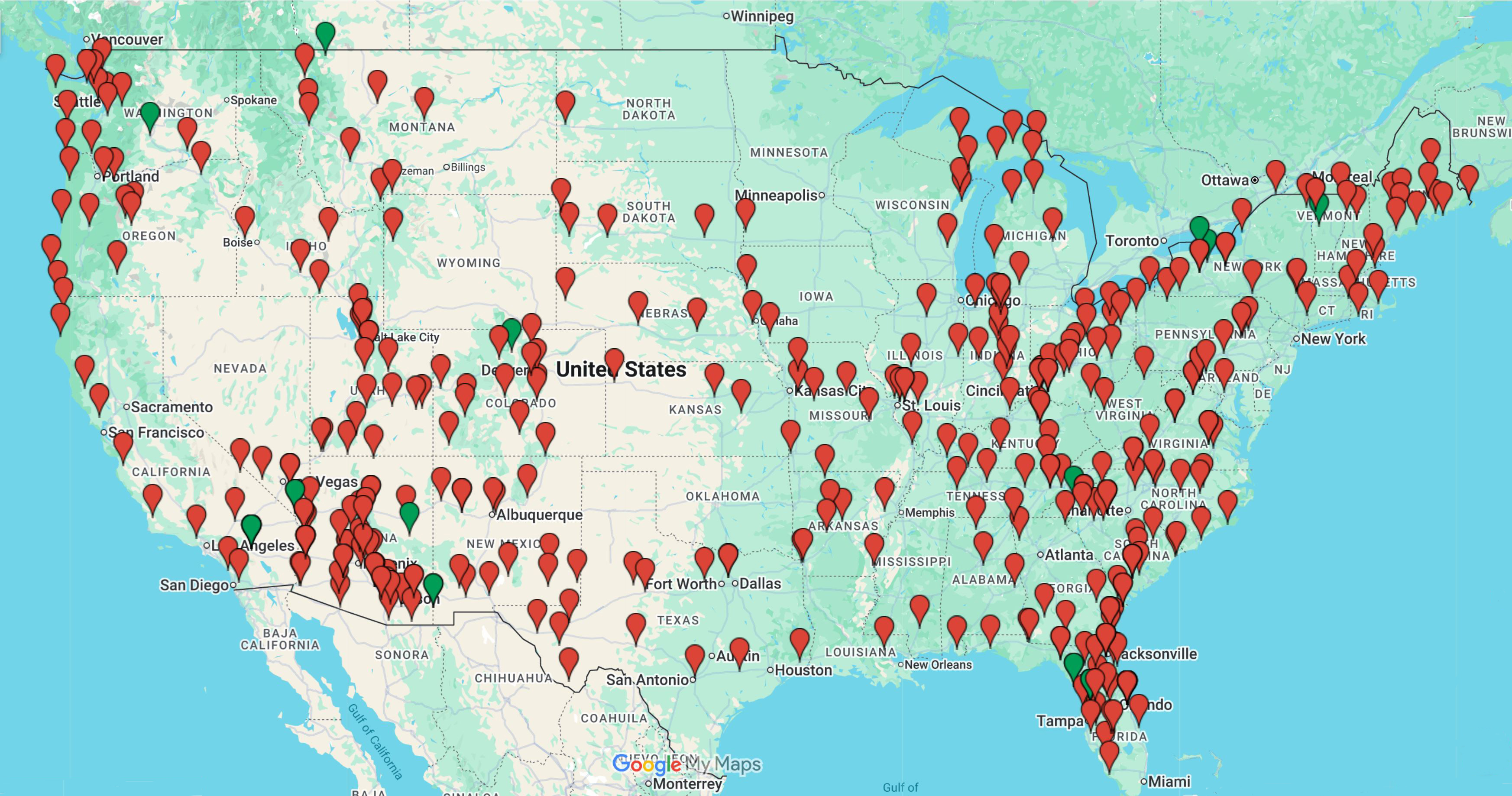
Below is a map showing all 401 places we have camped at over the past nine years. Just below the map is a link which will open up an actual Google Map. Doing so will permit you to pan and zoom around the country. Clicking on any pin will pop up a window with a link to the blog post(s) for that location. If you are visiting an area we have stayed near, our previous posts may help you find interesting places to see - especially if you are into hiking, mountain biking, geocaching or simply to see some photos from outings we took while visiting. We do not do write much about the campgrounds we stay in so don’t use the blog posts with the hopes of finding campground reviews.
We have some of year 10 planned out. After an excellent 2 weeks here in Marquette Michigan volunteering with the local Habitat for Humanity affiliate helping to build two different homes, we will be heading further west in the Upper Peninsula before dropping down into Wisconsin for the Oshkosh Air Show. Then we head into Minnesota for a month before starting our journey back to Florida for another winter season. No clue where next spring and summer will lead us.


Hi Jack & Chris, It's been a long time! Glad to see you are still out there enjoying life. We're still living full-time in our travel trailer and almost completing 7 years! I love your Elks lodge map and use it often and really appreciate the work you put into it. Safe travels and hope our paths cross again someday soon.
ReplyDelete