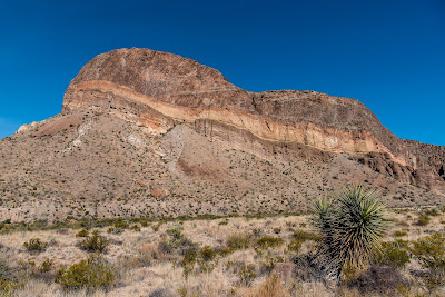
The Big Bend area of Texas is quite remote. It borders the Rio Grande River for over 100 miles, with Mexico just across the water. It includes both Big Bend National Park and Big Bend Ranch State Park. Our camping spot is situated between the two parks in the small town of Study Butte. The drive from Fort Davis is only a little over 100 miles. The road is very desolate but in good shape. We actually saw our first tumbleweed as we were heading out of Fort Davis, but I doubt it will be the last one. We stop in Alpine along the way while we have cell coverage and make a reservation in New Mexico. We weren't sure if we would have any coverage when we got to camp and since we will be arriving at this campground in New Mexico on Christmas Day, we thought it wise to plan ahead. Not only did that place have room for us, but they are doing a prime rib dinner that afternoon. Good timing on our part I suppose.
The campground we are staying at in Study Butte is Big Bend Resorts Adventures. I know it sounds impressive, it it may actually be the nicer of the several places in the vicinity, but calling this place a resort is stretching it a bit. Good thing we aren't here solely for the amenities. It's $25 a night for the weekly rate and has full hookups. The cable no longer works at the sites so we will be doing without television unless we feel like going to the game room and watching there. The internet at our site is not too good although Chris sometimes has luck for an hour now and then.
 |
| Nice Views from the Campsite |
 |
| Where's the Beef? A Short Walk from Camp |
The campground is convenient to both parks. The National Park entrance is about 3 miles away while the state park is about 16 miles away. Although the parks seem close, they are both Texas sized. The National Park is about 1200 square miles and the State Park about 470 square miles. For those familiar with Letchworth State Park back near our former home, it comes in at about 22 square miles. Admittedly the bulk of both these parks in Big Bend are remote wilderness that seldom gets explored. But it takes time to drive between places we want to see in either park. I'm glad we are here for 12 nights. We still won't get to see all the good spots but we should be able to get to many of them.
Day one didn't start out too good. I wasn't feeling 100% but couldn't quite pinpoint what was wrong. We took it relatively easy and drove into the National Park visitor center at Panther Junction. After showing our National Park Pass, they give us a window sticker. Fortunately it is good for a week, so we won't be forced to do this each day we come into the park. The ranger helped answer some questions and then started the 20 minute video to familiarize us with the park.
Next we drive down a dirt road for 6 miles to Gravevine Hills trailhead. This is a 1 mile hike out to a unique rock formation. The first 3/4 mile is very easy with the last quarter mile being a bit of a rock climb. Fortunately the exertion and fresh air seemed to make me feel better. The scenery along the way was pretty incredible but I suspect each hike we do here will be beautiful. The balance rock was impressive.
 |
| View Along Trail at Grapevine Hills |
 |
| Mountain Views |
 |
| Balanced Rock |
 |
| Chris Poses Under Rock |
 |
| Another View Through Opening |
 |
| Impressive View of Chisos Mountains |
 |
| Remaining Windmill at Sam Nail Ranch |
 |
| View from Sotol Vista Overlook |
 |
| More Mountains |
 |
| Heading Back to Burro Mesa Pourout |
 |
| Chris Dwarfed by Pourout |
 |
| Remnants of Dorgan House |
 |
| Looking Across the Rio Grande at the Wall |
 |
| Spotted at the Boat Launch - Probably Kayaking |
 |
| Approaching Santa Elena Canyon |
 |
| View Back North as We Enter Canyon |
 |
| Looking Up the Rest of the Canyon |
 |
| At the Water's Edge |
 |
| Homer Wilson Ranch and Its Backdrop |
 |
| Chris Checks Out the View From Inside |
No comments:
Post a Comment