Map of this blog's locations click this link to open the map
We found another hike even closer to Kremmling that sounded promising. The Gore Canyon Trail is an out and back hike just under 3 miles total and only 350 feet of elevation gain. The Colorado River slices through a mountain about 5 miles southwest of town. The canyon is quite visible from many places around town because it is so impressive with over a 2,000 foot drop to water level. This hike starts on the south side of the canyon where the river exits and continues downstream. The campground owner told us that many of the rafting companies start their trips near the trailhead and that the section of the river thru the canyon is too dangerous to raft at least this time of year. We drive along Trough Road to the Pumphouse Recreation Area and find one of the few nearby parking spots at the trail head.
 |
| Entrance to Our Hike |
 |
| Gore Canyon Trailhead |
 |
| Gore Canyon via Google Earth (Purple=trail) |
It’s a very busy place but the majority of the visitors are coming to start their rafting trip. There is a pretty good size launch area and shore line where the crew can get their rafts in the water and their guests geared up and on board. There are also some people with their own rafts getting ready to set off. The couple in one raft had their dog along and he looked ready to go. We can’t image our dog Shelby ever doing something like this!
 |
| Another Group Arrives |
 |
| Boat Launch |
 |
| Unafraid Dog |
We set off on the trail initially being nearly at water level. But it doesn’t take long before we start to climb a bit to get more of a bird’s eye view of the river. What surprised us was the train going down the tracks that seem impossibly positioned on the other side of the river. The tracks are about 150 feet above the river so we are below the grade of the track for the hike.
 |
| Starting Near Water Level |
 |
| Overlooking Broad Section of Colorado River |
 |
| Acceptable Trail Along River |
 |
| Butterflies |
Being so close to the river, the sound of the rushing water is quite loud, especially at sections of rapids. The first mile or so of the trail is in great shape and wide enough to not feel like it is too dangerous. But further along we start to run into some sections where the trail is washed out and it made for a challenge to get past them - especially for Chris with her fear of heights. We spotted a tunnel on the other side that the train track run thru. I was hoping that another train would make its way bay so we could see it going then the tunnel but that didn’t happen. After crossing several washouts, we get to one where we were unable to spot the continuation of the trail within the 60 feet or so we could see. We decided that this must be the end of the trail - at least for us. |
| Continuing Upstream |
 |
| Scary Washout Section |
 |
| Tunnel for Trains |
 |
| Rapids Below |
 |
| Apparent End of Trail |
We made it back across the several washed out sections and then could enjoy the rest of the hike back to the parking area. We had our lunch at one of the picnic tables before heading out. |
| More Rapids |
 |
| Heading Back |
Instead of going directly back to camp, we decide to continue our drive south along Trough Road. It is a beautiful drive and the dirt road is in such good shape that it didn’t detract from the drive. We stop at several of the overlooks and can spot rafters on the Colorado from time to time. We eventually get to the State Bridge Recreation Area. This got us into another Colorado county that we hadn’t found a geocache in yet but one was in the parking area and we found it. The old bridge at state bridge has definitely seen better days. More rafters were putting in at this location. One group was heading our way and not one of them was wearing a life jacket - seems risky to me.
 |
| Overlooking River Valley |
 |
| Storm on the Horizon |
 |
| Casual Rafters |
 |
| Long Gone Bridge |
Red Mountain RV Park is right next to a very large BLM (Bureau of Land Management) area. It is predominantly an off road vehicle area. Many of the people at the campground come in with all sorts of quads, motorcycles and RZRs to enjoy the nearby trails. I decided to see if I could find some decent mountain biking trails in the area. Often OHV trails are way too rough, rocky or loose for riding a bicycle but I set off north on County Road 22 next to the campground. It’s a uphill climb raising 300 feet in the first 2 miles. The OHV trail next to the road is much too challenging to try going uphill, so I stick to the road which had very little traffic. A mile up the road is a turn into a OHV “play area”. I take a look but decide going up against these machines isn’t a wise move.
 |
| Looking Towards OHV Play Area |
About 1.7 miles up the road, I spot a trail on the left that is a single track that appears to parallel the road. I start up it and find it is a fairly decent trail. It’s clear it doesn’t see much use and there are spots with prairie dog holes and encroaching brush that needs to be avoided but it was somewhat fun. I doubt Chris would find it fun but that would be her call. At about 4 miles out, I decide I’ve had enough and turn back. The ride downhill to camp was quite nice and I was even able to use the OHV trail I had avoided on the way up.
 |
| Riding the Single Track |
We were beginning to exhaust the hiking that was a short drive from camp and decided we should venture out a bit. About 30 miles north out of Kremmling on the way to Steamboat Springs is Rabbit Ears Pass - one of many passes on the Continental Divide in Colorado. Rabbit Ears Peak Trail sounded interesting if just for it’s name. It is a 5.5 mile out and back hike with almost 1000 feet of elevation gain. It’s an easy drive up US Route 40 and from more than 15 miles away, we can clearly see our destination - two closely spaced peaks jutting up on the horizon. I suppose they look like rabbit ears.
 |
| Rabbit Ears from a Distance |
There is a fairly large parking area at the trailhead near Dumont Lake Campground and it had at least 15 vehicles. Just several hundred feet along the forest service road, the trail splits off to the right. There isn’t good signage so we had to double check our map to confirm which way to go. The trail is along another forest service road and we see several vehicles along the way parked in some primitive camping areas. The road is plenty wide but quite rocky in spots. There are lots of wildflowers along the route which adds to the enjoyment of the hike.
 |
| Indian Paint Brush |
 |
| Columbine |
 |
| Loads of Flowers |
 |
| Facing the Sun |
For much of the early portion of the hike, Rabbit Ears is quite obvious so it seems like we are heading the right way. The trail starts at 9600 feet and rises to nearly 10,600 feet so it is a good workout on the lungs. We eventually get close enough that the distance view of Rabbit Ears has disappeared behind the forest. I was a bit surprised to see some last remnants of snow still on the ground in mid July.
 |
| Still A Long Way to Go |
 |
| Chris Waits While I Shoot Pictures |
 |
| Small Patch of Snow in Mid-July! |
As the trail nears the end, it follows a bit of a ridge which gives some nice views of the surrounding forests. The last few hundred feet of the trail is extremely steep, about 33% grade, and is rather rocky making for a bit of a challenge getting traction.
 |
| Pretty View Nearing the Top of Rabbit Ears |
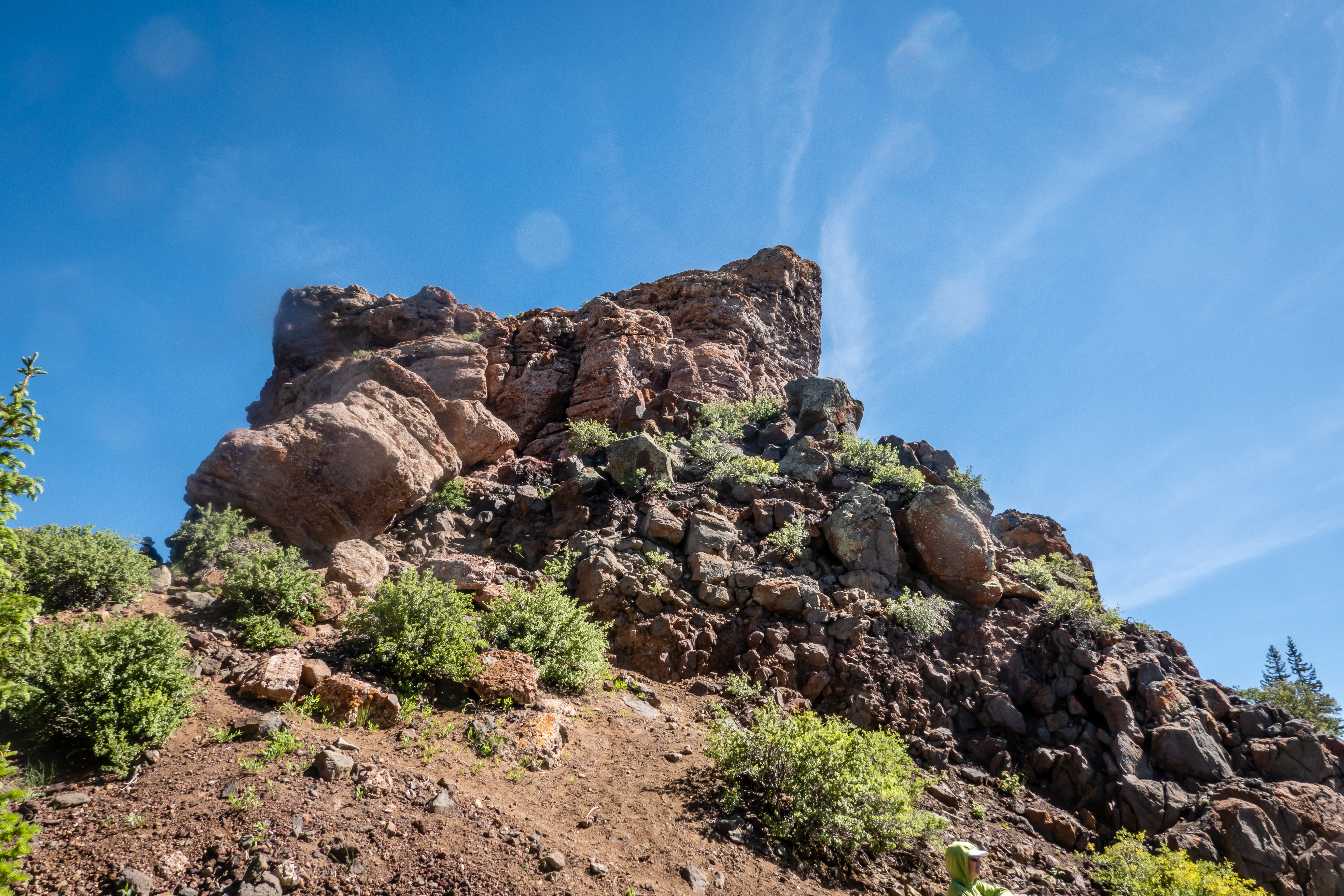
Once at the ears, it isn’t clear if people go to the very peak or not. We knew we wouldn’t be trying the rock climbing required to get there and I didn’t see anybody up there, but I bet it is attempted. Being right next to the ears eliminates the appearance of the outcroppings looking like ears but it was still good to make it and enjoy the views. We found a fallen log to act as a bench and enjoyed a snack while soaking it in.
 |
| One of the Ears Up Close |
 |
| The Other Ear |
 |
| Heavily Wooded Area Below |

The return trip was pretty good with the exception of the real steep part near the top. I struggled more than Chris because my hiking boots have seen better days and now have practically no lugs left on the soles. Even with my hiking stick, I nearly fell on my butt a handful of times in those several hundred feet. There were many more people heading up on our return trip. They almost all asked “are we getting close?” or “is it worth it?”. This was a fun hike.
 |
| Snack Spot |
 |
| Coming Up On the Steep Downhill |
We had done this hike early enough in the day to continue over the pass and head into Steamboat Springs. It was a Saturday and there was a farmer’s market in town we wanted to check out. The parking lot we headed to is right next to the rodeo grounds. There were lots of corrals with lots of bulls and horses resting for the night’s event. We cross over the Yampa River. There are dozens of people out enjoying a leisurely float in tubes on the river. Next to the river is a section of closed off streets with many vendors setup. Unfortunately there were not many people selling vegetables. Most had arts and crafts types of things. We wandered around and found a food truck with some good barbecue for lunch.
 |
| Bulls Waiting for a Rodeo |
 |
| Yampa River |
 |
| Farmers Market |
We drive a short distance to visit the Yampa River Botanic Park. It’s not a huge place - maybe 4 acres or so, but the gardens were beautiful. It’s right next to the river and a bike path that seemed to be quite busy being a nice Saturday afternoon. We may need to consider coming back here for a bike ride. We wandered all the gardens and took lots of pictures. It’s a nice stop if you’re in the area.


No comments:
Post a Comment