Wednesday, September 27, 2017

Back to Washington for a Volcano and an Ape

Map of this blog's locations click this link to open the map

Turns out that our stay at Barton Park in Boring Oregon wasn't very boring. We enjoyed the time here but now we need to head back north into Washington state. The main reason was another geocaching related destination. Back in 2001, a series of 13 special geocaches were placed around the world to celebrate the Planet of the Apes movie. Eight caches were in the USA and the other five were scattered around the globe. Since they were given a unique icon, they became ones that cachers really wanted to find. But by the time we started geocaching in late 2009, there were only 2 of them still active. One was in Brazil and the other in Washington state east of Seattle. 

We had never made it out to Washington before that one also went missing in 2011. I'm sure there were numerous people that made the trip to Brazil to get the last one but it wasn't likely we would do the same. Within the last year, a group of dedicated cachers went on a search and recovery mission. With a good plan and lots of perseverance (and some luck), they actually found the original container. The caching community was polled and it was decided they would hide the original container in the original location and make it available again. There was a big geocaching party when the cache was re-enabled and we really wanted to go to it, but it was only 2 days before the solar eclipse and we knew we couldn't do both the event and the eclipse. We figured we could head back to that area again before heading south for the winter.

Well that time is now. The destination is Snoqualmie Pass - where Interstate 90 goes over the Cascade Mountains east of Seattle. Being a bit longer of a drive than we like to do in a day, we looked for a good midway point on the trip. We could have just found a Walmart, truck stop or the like and made a quick overnight stop. But we really don't need to go at a fast pace and are consciously trying to NOT do that. We found an Elks Lodge in Kelso Washington, just across the Columbia River from Oregon. Kelso probably isn't a prime destination for many people but it is a reasonable drive to Mount Saint Helens from there. With that as our main objective, we head to Kelso.

When we pulled into the lodge, there were only 3 or 4 other rigs so there were numerous open sites for us to choose from. We head into the bar to register and are surprised at how many cars are in the parking lot. Upon opening the doors. We here all sorts of commotion in the bar. Turns out the Seattle Seahawks were playing and there was a large crowd of avid (rabid?) fans watching the game on multiple large screen televisions. We pay for 4 nights and head back to the rig to watch the game in a more peaceful setting. 

Our timing wasn't great from a weather standpoint. There was rain in the forecast for several days. On the first full day, we decide to just drive up to Mt St Helens and at least see what it's like even if it isn't great weather. We stop at the Mt St Helens Forest Learning Center prior to getting into the national park that is supposed to have a pretty nice education center. It might be nice, but it had just closed for the season so only the restrooms and small gift shop were open. We did do some of the short hikes and overlooks they have of the valley below and since it wasn't raining it was okay.
Overlook View on Way to Mt St Helens
Unlike many other national parks, most of the various stops at overlooks with the park don't require a fee or park pass. It's not until you go into the main visitor center on Johnson Ridge that you need to either pay your fee or show your pass. This fact required me to head back out to the car to get the pass we had hanging from the mirror. They have lots of  interactive displays that were quite interesting to explore. Johnston Ridge is north of the volcano which puts it on the side where the main eruption and flow occurred back in 1980. 
Coldwater Lake Near Mt St Helens

Boardwalk at Coldwater Lake
They have a pretty large and nice theater where they show a couple different movies describing what took place during the eruption. We have visited several other volcanoes during our travels but those have erupted thousands if not hundreds of thousand years ago. To have one that has happened within my lifetime was quite unique. A large screen lowers out of the ceiling and the dual digital projectors give quite a showing. They even have the subwoofers that makes the whole place shake making me wonder if the event is actually happening again. After the show is over the screen is raised out of the way and the curtains behind it are drawn back to display a breathtaking view of clouds! Yes it had really gotten cloudy while we were watching the show. What should have been a great view of the exposed crater was completely obscured. 
Johnston Ridge Visitor's Center

Scale Model of Volcano Area
A little bit later, the rain had stopped and we could at least go out and try to get a glimpse of the crater. Breaks in the clouds gave a hint of the crater and some of the newly fallen snow. We did a little exploring outside the building but the rain started again and forced us to just head to the car. This will need to stay on our list of places to visit again but hopefully on a much clearer day. 
Just a Glimpse of the Volcano

Large Tree Snapped Off During Blast of Volcano
Landscape Below Volcano Forever Changed

Rivers Heading from Mt St Helens
Our second day wasn't any better weather-wise so we knew there was no hope to see the volcano. And the third day was only marginally better. We just headed over the Cowlitz River to Longview to check out Lake Sacajawea. There are nice walking paths all around the lake with a couple bridges to take you across the long skinny lake. We do the complete 3.5 mile walk and enjoy it. We manage to get a few geocaches along the way and even find something else we have never seen before. Squirrel bridges! Yes, they (people not squirrels) have constructed a bridge of sorts between trees that appears to be flat and wider than the typical power line they might use. They even have a bit of a bridge look to them.
Lake Sacajawea

Squirrel Bridge

Closeup of Bridge
Our next stop is near Snoqualmie Pass. There aren't a lot of camping choices in the area or not ones for a rig our size. If we were in a tent or small trailer, there are plenty of options although some of the federal forest campgrounds were already closed for the season. While investigating options, Chris read in somebody's blog about a place called Valley Camp. It is a Lutheran Retreat just outside of North Bend. They have a campground that is open to the public although it doesn't show up in our go to app - All Stays. We had called a week or so beforehand and they had room for us. They have full hookup 50 amp sites with a $161 weekly rate. We figured it was a decent price and was very near the things we wanted to do. So even if it wasn't the best, it would work. 

The drive back up to this area was pretty. Most of the woods are evergreens but there are enough deciduous trees that are just coming into their full fall colors. Valley Camp is just outside the town of North Bend. Once off I-90, the road back to camp is paved, but also windy, hilly and somewhat narrow. There isn't much traffic on it so we manage to make it back. We were pleasantly surprised with how nice the place is. They have gravel sites that are spaced apart fairly well. We later found out that during the peak camping season, they actually double up and have people parked in the grass between sites. That explained why there were two sewer pipes at each utility pole. Unlike some of other commercial campgrounds that are right next to I-90, this one is far enough off the road that it was nice and peaceful.
Night Shot From Valley Camp
Besides the APE cache, the oldest cache in Washington state is also in the area. It's geocaching number is GCD. Which is the only 3 digit geocache that is still active. We decide to attempt this one on our first day. We are having pretty decent weather for late September but the cache is up on Mount Margaret just off I-90 near Hyak. Part of the way to the cache is on a steep and twisty forest road to the parking lot and trailhead. We  are a little surprised to find half a dozen other vehicles up here when we get there. Since we had done a series of caches along the drive on the way up, we decided to just eat our lunch in the parking lot rather than lugging it up with us. The initial part of the hike was scenic but close enough to the very busy expressway that it was fairly noisy. 
Heading to Mt Margaret
By the time we had gained much of the total elevation we would need to hike up, the clouds had rolled in and was actually looking like it might rain. This wasn't good since we really had planned for dry weather and didn't have the proper gear along. Of course once we got up to the elevation that our main goal was at, we ran into a little bit of snow on the ground from a previous day's snowfall. With this cache, we have now found the oldest active geocache in 20 of the states. 
After Finding Oldest Washington State Cache
I talked Chris into going up the trail a little bit further. There was a cache on the actual peak of Mount Margaret. The main trail only gets you to within about 300 feet of the cache, but how tough could 300 feet be? Well we never discovered a deer trail like we had been promised by the cache description and this last bit of trail was steep. But the biggest issue was the fact there were a couple inches of snow on the ground and it was really slick. There was one point where even I nearly said "that's it!", but we persevered and eventually made it to the top. Even with the clouds, the views were quite nice. It was a bit of a challenge to actually find the cache with the snow on the ground. I thought we had given up that aspect of the sport when we moved out of Rochester NY. 
Cloudy View from Mt Margaret

Overlooking Lake Margaret
We never did experience rain although it seemed like we did see a snowflake or two while up at elevation. The hike back to the car was pleasant. It turned out to be 6.7 mile round trip with a total elevation gain of just over 2200 feet. Of course that would mean we would need to put off the bike ride to the APE cache a day or two to recuperate. 

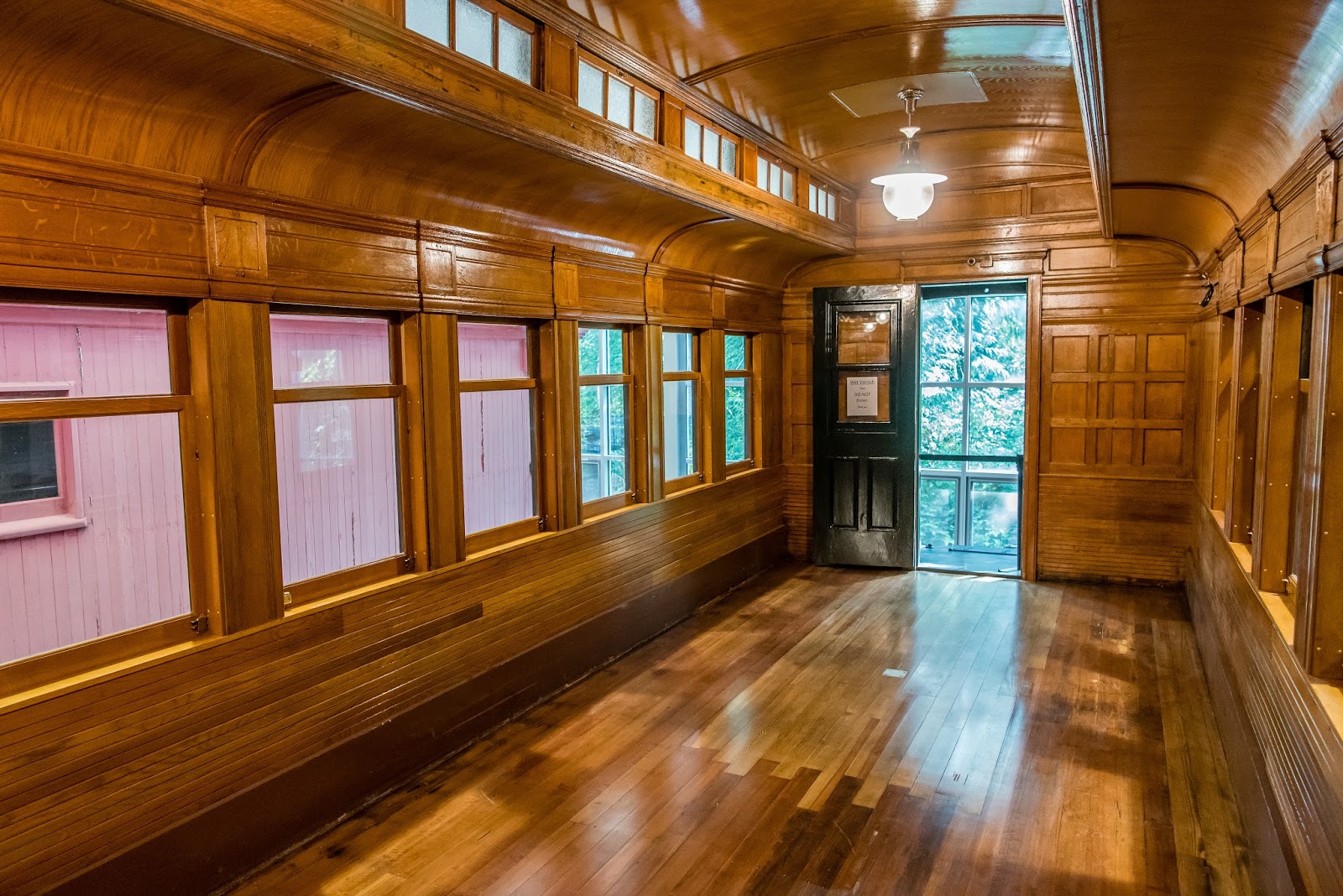
We stumbled upon the Northwest Railway Museum in the nearby town of Snoqualmie while doing an internet search. They have both a museum and an train ride. It turned out the the next day was Museum Day Live sponsored by Smithsonian magazine. All you needed to do was print out a coupon. In the case of this location, the coupon was good for free admission to the museum and half price off the train ride. So what would have cost us $40 without the coupon, we got for $10. We arrived at the museum just as it was opening, so we waited for a few minutes until there was a small group and the docent walked us through the museum telling us all sorts of interesting facts about the various cars and locomotives they have on display. Some are fully restored, while others definitely need some TLC. 
Caboose Could Use Some Work

Locomotive With Great Paint Job!
Possibly the highlight of the museum is the Chapel Car. This one was only recently finished restoration. In fact, there were still wet varnish signs hanging up. Since we hadn't seen the "before" condition, it is difficult to comprehend how much of the interior needed to be recreated. But as a woodworker, I could appreciate the detail that went into creating the gorgeous oak interior. I suppose if I needed to settle down and volunteer at a place, I would likely enjoy helping with the restoration work done at a place like this. In fact, other than a couple full time employees, the museum, train ride and restoration projects are all run by volunteers.
Wall Behind Lectern

Listening to Docent

Restored Woodwork
Next was our train ride. I'm guessing a few dozen people boarded the train at the museum. There are three cars to choose from. Each one was at a completely different level of amenities. For the first leg of the ride, we picked the last car. It seemed to have more of a box car theme rather than a passenger theme. The only seating was some well used wicker furniture but the two side doors were open with only a makeshift railing keeping people in the train. The first part of the ride headed up to Snoqualmie Falls. There isn't a terrific view of the falls from the train, but it was enough to pique our curiosity. There was a dog that is one of the "volunteers" on the train ride. Nader is an extremely mellow lab that has been part of the train ride since he was a few months old. That might explain how he was able to handle all the noises including the extremely loud whistle. 
Train Ready for Boarding

Volunteer Nader Relaxing on Train
Next stop is the depot in Snoqualmie. While we have the opportunity, we switch to the next car. This one is a real passenger car in reasonably good shape. Another short ride takes us past the museum into the stop in North Bend giving us the chance to switch to the third car. This one is in very good condition with stained glass transom windows. A short ride gets us back to the museum. The whole ride took about 90 minutes and went eight miles round trip. Not the best train ride we have taken but fun nonetheless. 
Snoqualmie Train Depot

Stained Glass in Passenger Car
Afterwards, we drove up to the falls to see them up close. Being a beautiful fall Saturday afternoon, the place was packed with people. There are a couple viewing platforms at high elevation. We needed to actually wait our turn to get to the railing to see the falls and take pictures. There is also a short but steep walk down to the lower water level and the power station. I was surprised how many people were doing the walk. Some of them didn't look like they would make it back up. Many kids were playing in the water but we opted to stay dry. There is a boardwalk that goes past the power plant and provides a good view of the falls. While we were enjoying the falls, we noticed people at water level but on the opposite side of the river. But not just ordinary people - a bride, groom and photographer. It wasn't clear how they even had gotten to their location let alone how they were climbing over boulders to get in the proper position for the photos. 
Snoqualmie Falls from Above

Enjoying the Snoqualmie River

Water Pipes Feeding Hydropower Plant

Falls from Below

Bride and Groom
The next day we decided to wash the rig since it has been several months since we had the opportunity. Then we took advantage of some of the trails they have at Valley Camp. Actually the loop trail on the property is only a mile long but it provides access to other trails. The main trail nearby is up Mailbox Mountain which is overlooking the campground. It sounds like a great hike but at over 7 miles long and over 4100 feet in elevation gain, we decided to skip this one and head back after a few miles of exploration. 

We had planned to go for the bike ride to the APE cache the next day, but a rainy forecast forced us to change plans. We did portions of a couple other hikes near Denny Creek. The area is near the pass over the Cascades. The interesting part is I-90 is elevated over the area a couple hundred feet. The Asahel Curtis Nature Trail circled through an area with some more of the enormous trees we have become accustomed to during our stay in Washington. We enjoyed the short hikes and stayed mostly dry. 
Along Asahel Curtis Trail

Westbound I-90 Overhead

Along Melakwa Trail

Chris Finds Shelter in Tree
By waiting to go for the APE cache an extra day, we had a great fall day. Of course that fact makes no difference for the first 2.3 miles on the Iron Horse Trail out of Hyak. That's because we get to ride through the Snoqualmie Tunnel. This trail is along the former Iron Horse railroad line. We have hiked through some tunnels that were a mile long but never one this long. Plus we were on our bikes. Chris used a headlamp and I used a flashlight. By taking it slow, we found it was a pretty easy ride. The trail surface is in good shape and didn't seem to be littered with lots of trash or have many bumps or ruts. There is even a geocache roughly halfway. Of course our GPSr doesn't work while inside the tunnel, which would make finding a cache problematic but the cache owner solves that problem by telling us it is in an alcove. There are 41 such alcoves roughly every 300 feet along the tunnel. We just need to keep track of how many alcoves we pass and stop at the correct one. We had no problems locating the one in the tunnel.
Chris Heads Into the Dark

We Find the Cache

She Makes It Out
Once out of the tunnel, we had a pleasant ride down to the location of the APE cache. It turns out the hiding spot is just off the trail out in the open in a large pile of rocks. Chris brought along some bananas as a snack to celebrate us finding this one - a fitting tribute. Since it was such a nice day and the trail is very nice, we continue on for several miles down the trail finding caches along the way. Near our turn around point, we find an interesting structure - an avalanche shelter. It was built over the train track at an area prone to avalanches keeping the tracks from becoming completely impassable. 
Western End of Tunnel

Nice View of I-90 Below

APE Cache Easy Find

We Found It

Nice Fall Colors

Avalanche Shed
We spent the last day taking advantage of the great weather and going for another bike ride. We drive to Fall City and find a parking lot for the Snoqualmie Valley Trail. This is a rail trail that extends over 30 miles. The trail itself is nice and wide and in great condition and there wasn't a lot of traffic. There are  dozens of geocaches placed along the trail so our effective pace is slowed down somewhat. We eventually make it to the town of Carnation and stop at Tolt River Park. There happens to be a campground here that looks like it could work for our size rig. We will need to keep this place in mind. The park is split in half by the Snoqualmie River. A unique suspension bridge allows pedestrians to cross the river where there are some yurts and a fairly elaborate trail system for hiking or biking. We might have considered trying it out but as it was, our ride ended up being 18 miles total. We pass a large farm in Carnation that has all sorts of autumn decorations. When we stopped to take a picture, three alpacas actually ran over to us. We are guessing they are used to being fed by visitors. Unfortunately we didn't have anything to give them so they lost interest.
Out for a Wagon Ride

Suspension Bridge at Tolt Park

Bright Barn

Not a Sign You Often See

Feed Us!

We really enjoyed our stay in the area and could easily have stayed for another week or two. The number of hiking trails in the Cascades could keep us busy and happy for quite some time. Plus Valley Camp turned out to be a real gem and we need to work it into our next trip in the area - whenever that will be. We already made plans for our trip to the Oregon coast so we can start our slow journey south for the winter months.

Saturday, September 16, 2017

In Search of Geocaching's Beginning

Map of this blog's locations click this link to open the map

With the Labor Day holiday behind us, we are hoping there will be fewer people out camping making our travels a bit easier. I guess that remains to be seen. Our next direction is back north. Our goal is to visit the spot where geocaching began. On May 3, 2000 the first "stash" was hidden about 25 miles southeast of Portland. Unfortunately, that cache is no longer active, but there is a plaque there with a geocache nearby and it is sort of the "holy land" for serious geocachers. That location is a bit further than we like to travel in a day so we pick a spot partway there. Springfield Oregon is close to Eugene and there is an Elks Lodge we hope to stay at. The other reasons for picking that area are twofold. First, there is a Newmar dealer not too far away and we are hoping they might have one of the new models that Newmar is just introducing. Honest we just want to look! The second reason is there is a highly regarded solar installation firm that we would like to discuss options for our rig.

There are Elks Lodges in both Springfield and Eugene, but the former will be more convenient for us. The problem is that they only have 4 RV spots. Since they don't accept reservations, we give them a call when we are about 40 minutes out. We are told they do have one spot left, but 3 other people had already called today inquiring about the same thing. When we pull in about 45 minutes later, we find that one spot is still open! The sites here are on the side of the lodge with rigs parked at about a 45 degree angle to the building. Of course the remaining spot is in between two other rigs. It wasn't too bad getting into the spot, but we did discover we were unable to open one of our bedroom slides without hitting our neighbor's slide. Oh well it will work. Two of our neighbors were there because where they had been was under wildfire evacuation orders and this is where they landed for a few days.

We call and make an appointment to meet with somebody at AM Solar the next morning.  The place is close enough we could almost have walked there. We had a good discussion with Ray and ended up leaning more towards upgrading our battery bank from flooded lead acid to lithium. This seemed to be a better first step than going with solar panels. Then in the future we could add on solar panels if we wanted to. Lithium batteries are not cheap but they have some real benefits over what we have. They weigh about half what our current batteries weigh and have a more forgiving charging and discharge profile. Ray agrees to get us a quote in a couple days. Jump forward a couple days. The quote came in at nearly $13 grand with over $7 grand in labor. Needless to say, I don't think this will be the path we take to get a better battery system.

After the morning meeting, we headed to the nearby REI to continue our bike shopping. They had one of the models I have been considering and it's price was reduced from when I looked at one a couple weeks ago. The saleswomen came out to help us and she said that some of the bikes had just gotten another reduction but she hadn't had a chance to make new price tags. She checks the one I'm looking at and it was down an additional $200. So now the bike is looking much better. We look around for a bike for Chris and they have an older model that looks good and is the right size for her. It too has a price drop and is now nearly half of the original price. We get both ready for a test drive which includes helmets and a safety vest. We haven't seen much rain in the last six months - maybe a few days here or there. Wouldn't you know, it has started to sprinkle as we take the bikes out for a test drive. Fortunately there is a linear park a block away that is underneath Interstate 105. It provides us with enough opportunity to try them out and we decide to go with them.

Found Outside the REI Store
So now we get back to the lodge with our two new bikes and our two old bikes. Something has to happen since we cannot travel with all four. A call to Chris' brother in Oklahoma give us the outcome of one bike. We will clean it up a bit, and send it to him. We find a nearby bike shop that actually has a bike box they haven't cut apart yet, we head there and pick it up plus some of the packing materials they have on hand. Chris discovered a web site called shipbikes.com that uses FedEx as their shipper, but gets much better pricing that we could get on our own. We package the bike up and weigh it and armed with that info, she is able to pay for shipping and print our the shipping ticket. A quick drive to FedEx and the bike is on its way.

The other bike could just be donated but it was a good bike nearly 30 years ago and I have kept it in good condition. So Chris offers to try selling it on Craigslist. I think she misses the hundreds of Craigslist sales we made when we were downsizing. We clean it up, take some pictures and place the ad hoping for the best. Well let's just say the phone didn't ring off the hook. Even after our price reduction on the second day, we had no nibbles. Maybe our area code being from western NY kept people from calling? Rather than bringing it along and trying again at our next destination, we just say goodbye and drop it off at a donation center.

It turned out with all the work on the old bikes, our four nights in Springfield flew by. Probably just as well. The Newmar dealer hadn't gotten in the model we wanted to see in person so that plan fell apart. And really there wasn't much else we wanted to see and do in the area. On the Sunday morning we are planning on leaving, the Elks Lodge is having a classic car show in the parking lot. Fortunately we get packed up and hitch up the Jeep before the parking lot got too crowded with owners and lookers. Our next stop is Barton Park in the little town of Boring Oregon.

We have a little time to kill before check in so we stop at a rest stop along Interstate 5 for lunch and a geocache. While Chris makes lunch, I head out for the cache. It is actually on the southbound side rest stop, but there is an underpass so I can walk to the other side without issue. With over 10000 finds, you might think that my experience at geocaching would translate into some level of intelligence when going for a cache. Maybe at least read the difficulty and terrain ratings if not the description. But no, I went for it with little forethought. I was initially on a bit of a path and less than 0..2 miles away. But then the path turned the wrong way and didn't appear to be making  another turn that would help. So I plunge into the brush in my shorts and t-shirt.

Had Chris come along, she would have been my sanity check and convinced us to turn back, but being the stubborn guy I am, I continue on. As the thorns from the brambles start to cut into my legs, it is slow (and painful) going. The last 300 feet probably took 10 minutes but by then I wasn't willing to turn back. A text from Chris telling me lunch was ready and asking where I was, forced me to try to go a bit faster. I finally get near ground zero and eventually spot the ammo can partway up a tree. Now I have the choice to try to back track they way I came which I know is bad but can be done, or try to head back a different way. I pick the later and it might have been marginally better but not by much. When I finally step out of the brush, my legs and arms are all cut up and I'm a bit sweaty which stings all the cuts. When I get back to the rig, I immediately hop into the shower to try to clean up a bit. Thank goodness we bring our home along with us. It can come in handy for times like this.

We arrive at Barton Park and it is apparent we have hit the slow season. As I try to navigate the extremely narrow opening at the entrance shack, the attendant says "You must be here for site 81." Yep, that would be us. The dump station is on the way out and is much too tight of a turn to make, so we pull into the campgrounds, disconnect the car, turn around, go to the dump station, can't make the turn into the park, so we have to exit, turn around and come back thru. At least I know I can squeeze thru without hitting a mirror if I go slowly.

We had booked this place a week or so ago since it was close to the geocache we wanted to do and looked pretty nice. We also tend to put a little thought into which site to reserve when that is an option. In this case, site 81 faces northeast. With a motorhome, keeping the front windshield pointing north or east can go a long ways in keeping the afternoon sun from baking us. Plus from the aerial, this site must have been a handicap site early on because the pad was a bit wider but apparently they decided to put the several handicap sites closer to the restrooms at the other end of the loop. We are only here for a week so the holding tanks would be fine but we really need to do laundry so we decide to use the shower facilities at the campground in order to do several loads of laundry while we are here.

Our first full day here, we decide to go for the "Original Stash Plaque" since that is what brought us here. There are a fair number of other geocaches that have been placed in the general area of this plaque. That gives people even more incentive to come for this one. In the back of my mind, I had formulated a vision of what I expected the place to look like. Well the actual spot didn't at all match my preconceived vision. I had envisioned it to be back in the woods like so many of the other "old" geocaches we have found. And yes, a simple look at the map would show the thing is basically at the side of some seldom traveled back country road where you can pull over and walk 50 feet to find it but I wanted a half mile hike in the woods. Fortunately some of the other caches nearby offer that walk in the woods. The owner of the adjacent private woodlot has many trails and has permitted geocachers to place and find caches in his woods.

We Found the Plaque Where Geocaching Started
Since this expedition didn't take us nearly as long as we had planned, we needed to come up with something else to do for the rest of this pleasant day. A quick look at the map shows that Milo McIver State Park is very close by. There are a couple geocaches there and a fish hatchery. After having the picnic lunch we brought along. We head to the hatchery. There wasn't much going on. It was open, but we saw no other visitors or employees for that matter.. There are three large holding ponds of which only one was in use. It contained what must be tens of thousands fingerling salmon. At any point, there were several of the little guys jumping out of the water. At the three large pipes where water is pouring in, the fish seemed to be trying to jump into the flow and head up the pipe. I guess that urge to go upstream starts at a young age. The numerous sea gull sitting on the side of the pond have likely found this to be the primo spot to find fish!

Small Fry Pond

Look Closely - Small Fry Mid-Stream
Below the large ponds, were several holding tanks for adult salmon. There were quite a number of ones that looked like they would make a nice dinner! Just below the holding tanks, all the water being let into the upper holding ponds, flows out and down a stream into the woods. A fish ladder leads into a fish trap, where salmon returning from the wild end up. Many of the returning ones are then used as breeding stock for the next generation at the hatchery.
Salmon Dinner Anyone?
At the other end of this park is a nice looking disc golf course. Of course we have removed our discs from the Jeep when taking the boxed bicycle to FedEx so we can't try it out. But we do hike the roughly 2 mile Maple Ridge trail. It is a nice hike, and being a Monday, there are hardly any others out using the trail. All in all, it turned out to be a nice day.

In looking for a place to try out our new mountain bikes, we discover Powell Butte Nature Park. It is a 600+ acre park east of Portland with miles of hiking and biking trails. It is an extinct (we hope) volcano that now happens to be the main water source for Portland. Not that the water comes from here, but is stored in two 50 million gallon underground reservoirs. The park turns out to have some really nice trails and for the most part is not so crowded to make biking a challenge.

View from Powell Butte
With one successful bike ride done, we decide to go out the next day and do a section of the Cazadero trail - a rail trail that goes right past the entrance to Barton Park. There are a series of 20 geocaches placed along several miles of the trail near the park. It is quite difficult to get into a cycling rhythm when we need to stop every tenth mile or so. Sections of the trail has fairly loose gravel that can make the ride challenging. We end up doing 11 miles out and back and find 17 of the 20 caches.

Earlier in the month, a cousin of mine from Ohio was vacationing in northern Oregon while we we in southern Oregon. We didn't get a chance to meet up, but she did post pictures from a hike that might be one we should try.  Now that we are back in the area, we plan to do the 6 mile hike to Mirror Lake and Tom Dick and Harry Mountain. This brings us back to the exact location where we had mechanical problems with the motorhome while heading over the Cascades for the eclipse. As we approach the parking area for the hike off of US Route 26, we can tell it is full. In fact, somebody is sitting in a car hoping a hiker will get back and free up a spot. We continue up to Mt Hood Ski Bowl parking - right where we diagnosed our problem a few weeks ago. Parking up here adds another mile each way, but it beats just waiting. At least the state realizes this is a very popular hike and has plans to create a new parking area near where we parked and modify the trail to head there instead. Maybe next time we are in the area it will be completed.

Route to Mirror Lake & Tom Dick and Harry Mountain
This hike is a nice one. The trail is in pretty good shape and even though there were lots of cars, we don't feel too crowded on the trail. There are a few geocaches to entertain us along the way. One was near two women resting on the trail, as we passed, we told them what we were up to so they wouldn't grow suspicious. We were just signing in as they walked by so we explained geocaching to them. Maybe they will investigate it since they obviously enjoy hiking and geocaching is a great companion activity for hiking. It was a nice day for a hike but admittedly the smoke from the nearby fires have messed with the distance views yet again. At least the air we are breathing doesn't seem to be too smokey.

After a brief stop at Mirror Lake about halfway up, we continue on the trail up to the overlook of Tom Dick and Harry Mountain. The trail ends at a very rocky overlook area with about half a dozen others enjoying the limited views. One woman had even brought her very young baby up with her. We enjoyed the sandwiches we had brought along while trying to keep the very persistent chipmunks from just climbing in our laps to take a bite for themselves.
Mirror Lake

Mt Hood Shrouded in Clouds
There was one last geocache up here but it was 500 feet or so further from the overlook. There was no obvious trail in that direction and walking on the rocks was precarious at best. We managed to get past the rocky part and found a deer trail that led us right over to the cache. As we came back up to the overlook, a new group of people looked at us and wondered where we were coming from. If they only knew about geocaching. The return trip was more of less uneventful except for near the beginning. Two guys were having a pretty loud conversation behind us and it seemed like we were going to get to enjoy the whole thing. It didn't take long before I gave up and stopped to "tie my boots" in order for them to pass. Once they were out of earshot, we enjoyed our hike back down. We stopped at Mirror Lake again where another chipmunk came a begging. It was a nice hike. I'll be curious if any other of our cousins will make it out for this hike?
View Along the Way

Mount Hood

Mount Hood with Mirror Lake in Foreground

We had been doing lots of hiking or biking so we decided to mix it up a bit and do pure touristy things. We drove into Portland and went to Washington Park. It's a big place with several gardens, some monuments and museums as well as the zoo. Parking isn't free, but $6.50 got us an all day spot near the Japanese Garden. We stood in a pretty long line to pay to get in. I guess many other people decided to take advantage of the nice day. After checking out one of the buildings and all it's artwork, we proceeded into the garden area.

Crane Sculptures

Pagoda
Our timing was perfect, a docent informed us he was just starting a tour and asked if we wanted to join in. Sure, why not. It turned out to be a fairly large group of about 25 people. It wasn't always easy to be close enough to hear all his stories about the place, but we caught enough of it to be quite entertaining. He turned out to a wealth of information not just about the gardens but Japanese culture as well. He clearly wasn't Japanese but that didn't seem to hinder his enthusiasm for the topic. The only downside to doing the tour is not being able to take my time to take pictures or read signs. So after the hour was over, we did a little more exploring on our own.
Pond

Waterfall with Triangle Rock (Crane) and Flat Rock (Turtle)

Nobody on the Bridge
By now it was lunchtime and we hadn't brought anything along. There were no places to eat, or food trucks nearby. There is a free shuttle that runs a loop around the park. So we hop on the next one after figuring out where the stop was, and head to the zoo. The hope was the zoo would have some sort of dining choices. Sure enough, as we entered the zoo, we found a cafe with reasonable food and had lunch as we looked at the zoo's map to plan our visit.

This zoo actually has a couple physical geocaches located within its confines. The two we did each have a combination lock to keep other visitors from getting in, but armed with the combinations, we had no real problem. It was too crowded to wait for complete anonymity when opening the caches but surprisingly the other people didn't seem to even notice.

Hungry Hungry Hippo
The Race is On
Heading to Next Feeding Station
The zoo was nice. Not super big, but plenty to see and do. The lions were likely fed shortly before we arrived there. They were up and quite active. Many were licking the ground, possibly where the food had been tossed earlier. The bats were in the process of being fed. They get all sorts of fruits hanging from hooks on the ceiling of their cage. There was a lot of activity as they would fly around and then hang upside down while eating.
Look at My Tongue

Staring Contest

Bat Feeding Time

I Have a Long Neck
We still had a little bit of energy and daylight remaining so we jumped on the shuttle and went back up to see the rose garden. Being mid-September, we were quite surprised by how many roses were in bloom. We strolled up and down the aisles taking in the sight and smells. Since we weren't sure how bad traffic would be back to the campgrounds, we headed out before sunset and made reasonably good time back.


We had one more full day to spend in the area and Chris had stumbled onto a Hopkins Demonstration Forest during her investigation of what else to do. This place is a privately owned 140 acre parcel of land where the owners have dedicated many decades to practicing various forms of woodlot management techniques. They have miles of trails and it is open to the public. There also happen to be about a dozen geocaches placed there, so we had added incentive other than just a walk in the woods.  Along the trails, there are signs explaining when each plot was planted and subsequently thinned. They even have some pretty elaborate displays with all sorts of info regarding the practices, goals and results. As former woodlot owners, we found the info quite interesting. Obviously these owners put much more work into woodlot management that we did.

Detailed Signs

Forgot our Throwing Axes
We actually did fairly well with the geocaches. There was one multi cache that hadn't been found in almost a year. It took us a great amount of effort, but we made the find. Another one of the caches was a puzzle cache that didn't provide the actual coordinates for the container. In order to find it, we needed to find six other caches in the series along the trails. Each cache provided one digit needed to produce the final coordinates. Our problem was we couldn't find 2 of those six caches. With only 4 of the numbers, we made some educated guesses what the other digits would need to be in order to stay on the property. And then with some luck we found a trail that went past one of the guesses and Chris managed to find the container. We enjoyed the hours we spent wandering on this beautiful property.