Map of this blog's locations click this link to open the map
Back in June, we had visited Penn Yan and did some short walks along the Keuka Lake Outlet Trail to see some of the waterfalls and old mills closer to town. The trail itself runs from there to the town of Dresden to the east and is just under 7 miles in length. This seemed like a perfect trail to visit on the mountain bikes. We looked at the elevation profile of the trail which only has a 300 foot change but if we start at the Dresden end of the trail and head west, we will get the uphill done during the first half of the ride and have an easier ride back to the car. We pulled into the parking area at the trailhead and saw a guy getting signs out of the back of his truck. They were signs for a running race along the trail tomorrow morning. We were glad we decided to come out on Friday instead of Saturday.
The trail was in great shape for our ride with only a couple of sections with a little bit of mud. It was a fun ride and we stopped at the several falls and mills along the way - most of which we had visited a month ago. As we got into Penn Yan, we ran into the same guy putting up signs for the race at this end of the course. The trail stops at a little park in town with baseball fields and restrooms. There weren’t too many people on the trail so it was a pleasant ride. We didn’t really notice we were heading uphill during the first half of the ride, but were pleased that the return trip was definitely easier as we headed downhill back to the car.
 |
| The Falls at Cascade Mill |
We also took advantage of this ride to try out something new - at least to us. Adventure Labs (AL) are an extension of geocaching that have been around for a couple years. They are similar to geocaches in that they are location based but are quite different in that there is no physical container to be found. From within the Adventure Lab app on your smartphone, you will be guided to some location. Once you are within some proximity of the desired location, usually 50 to 100 feet or so, you will be presented with a question that you must answer to receive credit and move on. Sometimes the answer is located on a sign or it may be observable - like how many decorative tiles are above the main entrance. Each AL typically has 5 to 10 stages and each stage counts as a find. There are over 60,000 of these all over the world and many of our geocaching friends are into them big time and they do sound like they are fun. But we hadn’t gotten into them for one simple reason. They get included in with your statistics for geocaching and I really don’t consider them to be “geocaches”.
When we were at a geocaching event a couple of weeks ago, we were discussing Adventure Labs with our friends and explaining my reluctance in doing them. While they didn’t share my same concerns, they understood and had a couple of suggestions. One was to have a separate Geocaching account for doing ALs. I decided this might be a good alternative for us. We can start to do some of the fun sounding ALs as we travel the country but not have them affect our geocaching statistics. I created a new account that uses our geocaching handle - “rushrutter” - and tacked on “AL”. This approach works out well because I am always logged into the AL app with my new handle but always logged into my geocaching app with our original handle so I don’t inadvertently log either type from the wrong account. The Adventure Lab along the outlet trail had 5 stops and we learned a few things from the descriptions provided. As of this writing, we have done 27 AL with a total of 168 finds in the past 48 days.
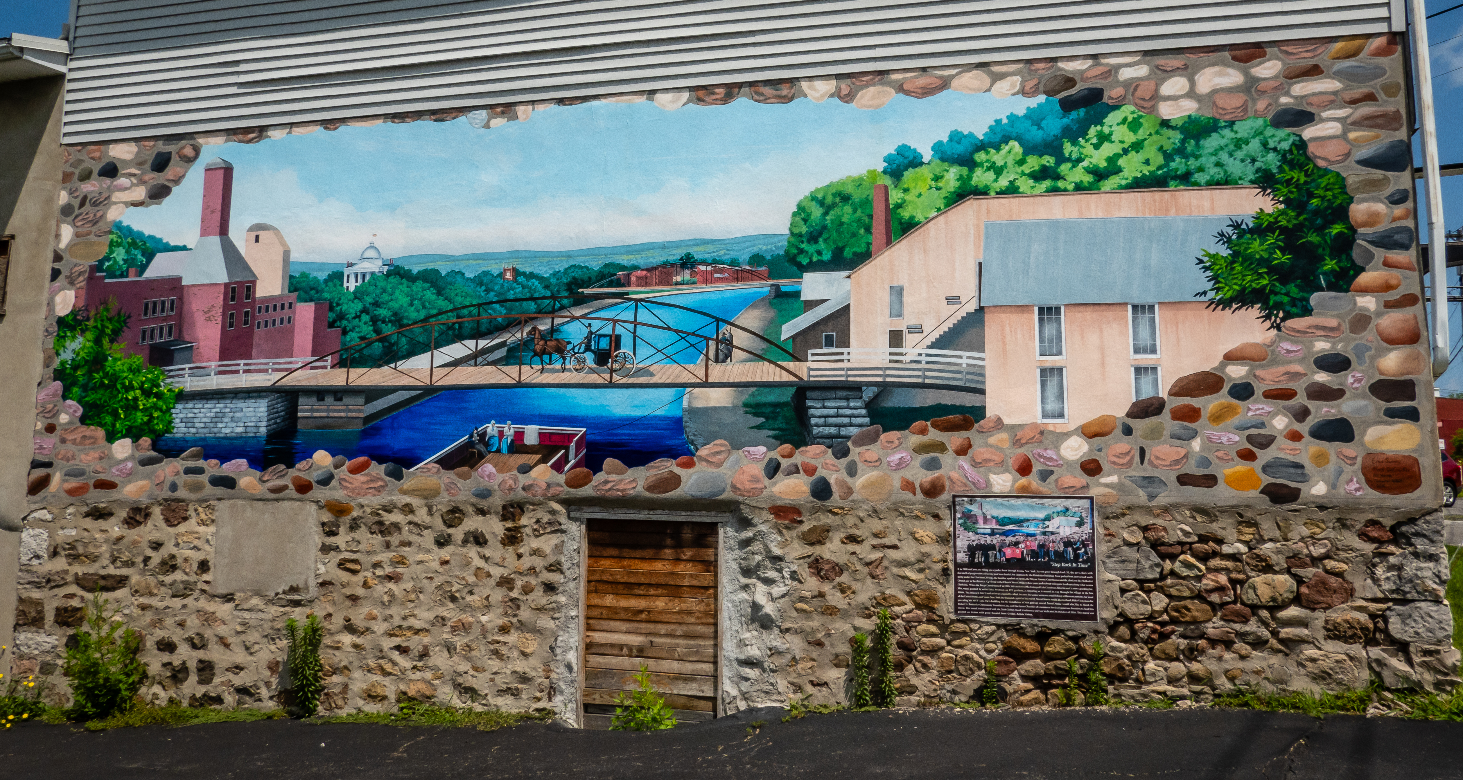
The following day we head north up to the Erie Canal for another bike ride. Having spent 32 years in western New York, we are quite familiar with the canal but even those that have never visited the area likely know this iconic 360 mile route because of the famous song - Low Bridge Everybody Down or Fifteen Years on the Erie Canal. Sorry if you find yourself singing the few words you know and mumbling the others for the rest of the day! Our destination was Lyons NY. The plan was to explore the town on foot while visiting the 10 stages of the Adventure Lab that led us to various murals located around town before hopping on the bikes and riding the canal path to the town of Clyde about 8 miles to the east. There was a large parking lot near downtown that would work out well for plans.
 |
| Welcome Sign Along Canal |
 |
| Erie Canal in Lyons NY |
 |
| Looking Towards Lock #27 |
Lyons has done a pretty good job of developing and keeping the area near the canal in good shape. Being the county seat of Wayne County might help this town compared to some others. We enjoyed walking around and seeing the murals we were led to. Lock 27 of the canal is located right in the heart of town. It has a lift of 12.5 feet but no boaters were passing through it when we were there so we didn’t get to see it in operation.
 |
| One of the Larger Murals |
 |
| Another Erie Canal View |
 |
| At Lock #27 |
 |
| Former Hotchkiss Building |
As might be expected, the murals mostly seemed to have a canal theme and many of them were quite good. We learned why the town used to be known as the Peppermint Capital of the World. Back in 1841, the Hotchkiss company was one of the world’s largest producers of peppermint oil.
 |
| Mule Named Sal |
 |
| More Mules at Work |
 |
| Mural Blends in with Building |
As we were finishing up our tour, we stumbled onto the farmers market held each Saturday morning. It was a rather small group of vendors but we looked them over to determine if they had better options for lunch than we had brought along with is in the car. The courthouse is a pretty building with a large domed roof. We think we even spotted the old Elks Lodge building based on the large elk head mounted over one of the doorways. We got back to the car and found a shady spot under a tree to have lunch and then got ready for a bike ride.
 |
| Wayne County Courthouse |
 |
| Looks Like an Elk to Me |
The trail to the east starts out following the main Erie Canal but a little over a half mile into the ride, the canal veers to the southeast and the trail follows what was likely the early canal route to the east. It is a pretty bike ride for the next few miles. We pass one of the old locks from the 1840’s. It was lock #54 or also called the Berlin Lock. At about the 5.5 mile mark, the trail dumps onto a road and continues east. This road is apparently old State Route 31. It is in great shape to bike on but doesn’t look wide enough for two cars to pass one another. It didn’t matter, since we didn’t come across any cars for the mile or so we are on it.
 |
| Heading East Out of Lyons |
 |
| Old Lock #54 |
The trail then goes along the current Route 31 for another mile before we get into the town of Clyde. There was definitely more car traffic along this stretch but the road has a wide shoulder so it isn’t too bad to bike on. We stop in the center of town to start another Adventure Lab that consists of 10 stages that tour the town. There is a gazebo and fountain as well as a few memorials. This AL was mostly concentrated in the few blocks near the center of town but did have some stages that were on the south side of the canal so it was a good thing we were using our bikes instead of just walking. The old Smith-Ely mansion was one of our stops. Originally built in 1850 and expanded in 1875, this is a neat old place but it is definitely in need of some work. It has been converted into a bed and breakfast and looks like there are tours offered as well. We were on a mission so we didn’t take time to see the inside.
 |
| Fountain in Clyde Town Square |
 |
| Smith-Ely Mansion |
The Lauraville Landing Park on the south side was a cute little place with a playground, shelter, boat dock and restrooms. Our last stop in town was at St Johns Cemetery about 2/3 mile west of town on the south side. We passed a big old barn that looked like it isn’t going to be standing much longer. The view from the bridge over the old canal provides a nice view and we even got to watch the afternoon Amtrak train whiz by. The return trip was pleasant and by the time we got back to the car, we had gotten in a 19 mile bike ride.
 |
| Lauraville Landing Park Boat Ramp |
 |
| Barn Gets a Big Skylight? |
 |
| Canal at Clyde NY |
 |
| Amtrak Train Screams By |
The next day we had something quite unusual planned. We were going to the Seneca Meadows Landfill. Not to drop off some trash but to go to their annual open house! This place is rather apparent heading north out of the Seneca Falls & Waterloo area. The hill created from the landfill towers over 200 feet above the road. We had seen advertisements for their open house and it sounded eclectic enough that we needed to go check it out. We weren’t expecting there to be too many people there but when we arrived about 15 minutes after it officially opened, there were already over a hundred cars filling the parking area and we needed to park a quarter mile away. I guess this was much more popular with the locals than I anticipated. I guess that’s what happens when the business offers free food. There were several large tents set up in the huge paved parking area and there was a line of people formed to get in. We weren’t positive how this worked, so we just lined up like everyone else. We were pleased that there wasn’t a bad smell like we were anticipating from being at a landfill.
 |
| Long Line Entering Landfill Open House Event |
Check in was rather simple. They only wanted to know where we were from and how we heard about the event. They had one tent setup with all sort of different displays on things like recycling, composting and how a landfill works two other tents had lines for food. It looked like one was for a chicken dinner and the other was for hotdogs and hamburgers. The lines here were long too, but they moved exceptionally fast. We got a quarter chicken, salt potatoes and a salad plus a drink. The desert was ice cream bars so we decided to come back for those given how hot an afternoon we were having. Another tent had a rows of large tables but even with the massive crowds, we found a spot to sit and eat what turned out to be a rather good lunch.
 |
| Dirt Track Cars on Display |
 |
| Tour Bus Heads to Top of Landfill |
After eating, we headed to get an ice cream bar and go stand in line for the bus tour. There were two large tour buses that kept cycling though every 15 minutes or so. The line was long enough that we had to wait for the next one to return, but it was very efficient. Once on the bus, the driver was good at filling up all the seats. I’m guessing there were 50 people on each bus trip. One of the landfill employees jumped on and stood up front to give a description of the landfill’s history and how it works. It’s about a one mile drive up to the top and we learn a lot about the operations here. Much of the discussion is about how the landfill is designed to prevent contaminates from leaching into the water system. The methane produced is captured by a huge network of pipes and is actually taken across the road to a facility to turn the gas into electricity. At the top, we stop for a couple minutes so we can look out over the new area that is being created. Pictures through the heavily tinted bus windows was a bit of a challenge. This is where an old style school bus would have been better.
 |
| Waiting to Board the Bus |
 |
| Overlooking New Section of Landfill |
 |
| Heavy Equipment Idle on Sunday |
 |
| Overlooking Open House Tent Area |
Once we’re back at ground level, we explored some of the other things they had. The bounce house was quite popular. There were several pieces of heavy equipment from the operations on display. The big bulldozer had a set of wooden stairs to a platform so you could get up close if you wanted to. The mini excavator was actually running and kids could sit in the seat while the operator grabbed tires with the bucket and thumb. I’m not sure how it would look if an adult tried to do the same so I only admired them from a distance.
 |
| Bounce House |
 |
| Bulldozer |
 |
| Mini-Excavator |
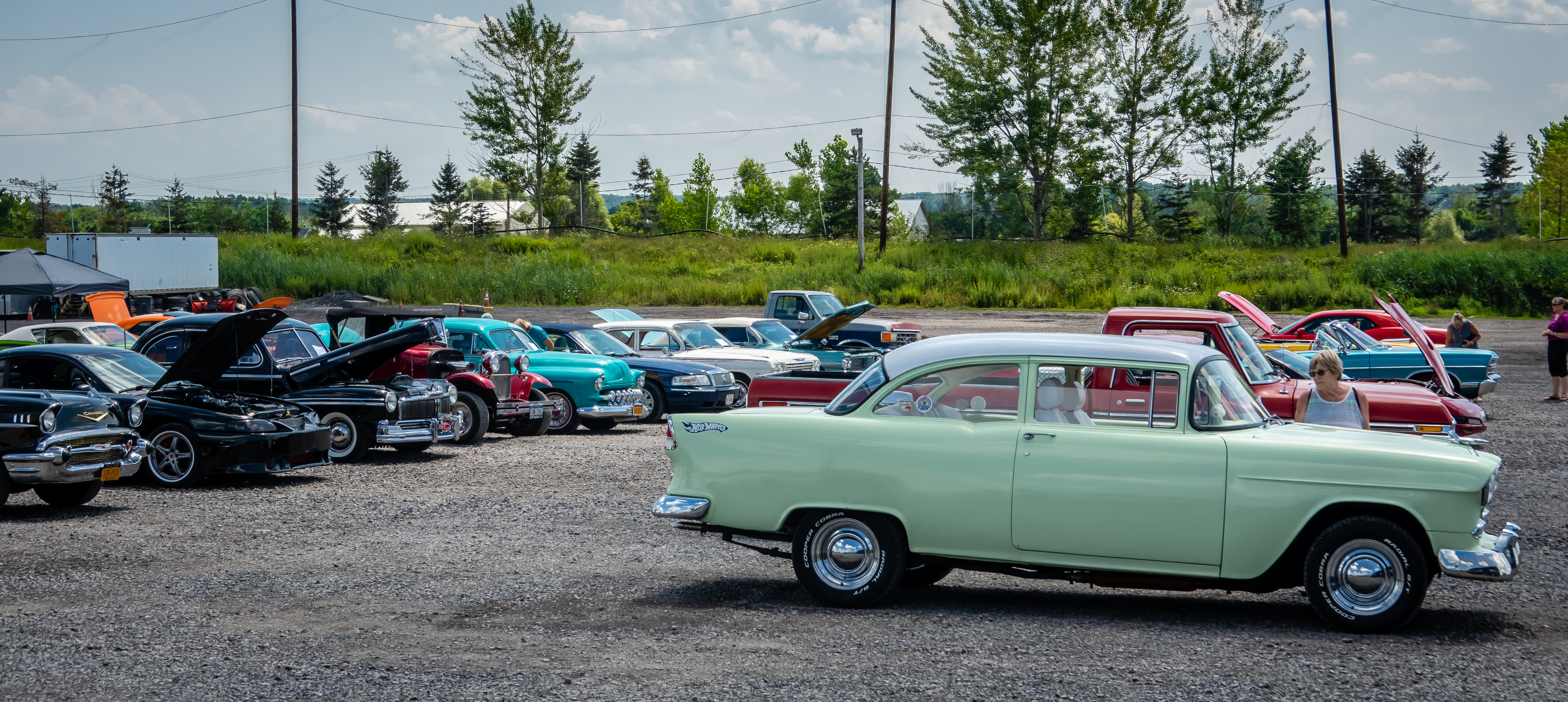
In the gravel lot adjacent to all the tents was a classic car show. There were maybe 50 vehicles some were pretty good looking while others didn’t really seem like they fit in. Another tent had some raptors on display. We ended up spend 2 hours in total at the landfill. We learned a lot and enjoyed seeing things up close instead of just in passing from the road.
 |
| Classic Car Area |
 |
| 1956 Ford Ranch Wagon |
 |
| 1956 Corvette |
 |
| 1961 Ford Econoline Truck |
 |
| Bird of Prey on Display |
 |
| Entrance Scales at Landfill |
On Monday we headed out to Sampson State Park. This was one of the first places we camped in the travel trailer we had just gotten back in 2010. This is a very interesting place because of its history. It was a naval training center during World War II and later became an Air Force base during the Korean War. I’ll describe more about the history of the place in a future post. Nearly all of the original buildings are gone except for the old brig which is now a museum. Of course we hadn’t bothered to check which days it is open so we arrived on a day it was closed.
 |
| Sampson Memorial Museum |
 |
| T-2C Buckeye |
 |
| Shiny Monument |
That wouldn’t be a big problem because we had come to do some hiking and some geocaching. There was also an Adventure Lab that would give us a short tour of some of the grounds. Many of the trails here are actually simply the remnants of some of the 53 miles of roads that were built on the base. It has been over 10 years since we have visited the park and it has changed quite a bit. There is a new camping area that actually has seasonal sites and doesn’t seem to be associated with the state park campground. Plus there are some new cabins with nice views of the lake. We spent about two hours exploring but realized this place is best seen by bicycle plus we want to come back when the museum is open so we will be back.
 |
| One of Many Old Roads to Explore |
 |
| The Shore of Seneca Lake |
 |
| Modern Cabins for Rent |
 |
| New Seasonal Campsites at Sampson |
We had our follow up doctors appointments later that day. By now, our doctor had seen all of our test results so we went in for his take on our health. We both had pretty decent test results. There wasn’t anything that prompted him to declare we need to go on all sorts of drugs. We both could stand to lose some weight but with some minor lifestyle changes, we should be able to maintain our status quo. Plus since we realized we wouldn’t be back in the area in the foreseeable future, going on some permanent schedule with this doctor wasn’t going to work out for us.
The next day we head to another county park we used to visit fairly regularly. Powder Mills Park is on the southeast side of Rochester between Pittsfield and Victor. It’s a 380 acre park with over 8 miles of hiking trails. It’s generally wooded and can be quite hilly. We didn’t plan on doing any of the longer hikes but did want to grab a few geocaches and also tackle the Adventure Lab that has 5 stops in the park. We really enjoyed getting back here and doing some exploring even if it was just a short time. One of the neat features of this park is the fish hatchery. It isn’t very big with only 6 races so it doesn’t come close to some of the ones we saw in Colorado last summer but it was still fun to see the various size of trout - some big enough to be dinner.
 |
| One of the Races at Hatchery |
 |
| Big Trout |
Since we hadn’t gotten too sweaty during our visit to the park, we drove into Rochester to check out the REI store. Chris had some specific things she was searching for and I just came along to look. I headed back to the returned and discounted merchandise and discovered a pair of Oboz hiking boots that had been returned with no noticeable damage in my size. Better yet they were half price! I already have a backup pair of boots hiding underneath our sofa but I just couldn’t pass up the deal. I hike enough that I know I will eventually need them. On the way home, we stopped at another favorite restaurant. The King and I is a Thai place that has some excellent food. Our go to is the chicken in peanut sauce. Mmm, mmm good.
A few days later, we head out for another bike ride. This one would on another section of the Ontario Pathways Trail. This time we would pick up the trail at the parking lot just north of the trail crossing over Routes 5 & 20. It was going to be another hot day so we came out for a morning ride hoping to beat the heat. There is a rather steep spur trail from the parking lot down to the actual trail and it wasn’t in very good shape so we opted to walk this section. Once on the trail, it was a nice ride. Mostly shaded and fairly flat. We had a few geocaches to find along the way. Heading south for about 2.5 miles we approach the small town of Stanley where the trail make a sever right hand turn to the northwest.
 |
| Today's Route Along Ontario Pathways |
This section of the trail extends for over 11 miles and heads into downtown Canandaigua. We knew for sure we wouldn’t be heading that far because it was starting to get pretty hot. There is a really neat (but narrow) bridge over Flint Creek. This one is close to 35 feet over the water level so it provides for a decent view. We made it another 4.5 miles before turning around. We probably went a little past our bodies halfway point and we were struggling to get back. We debated about taking some of the roads in the area but figured that we would be more in the sun plus the heat from the asphalt road wouldn’t help. It ended up being 14 mile ride - 12 would have been better!
 |
| Narrow Bridge |
 |
| View of Flint Creek from Bridge |
We finally made it back to Seneca Falls after attending a festival a couple weeks ago. This time we wanted to visit the Women’s Rights National Historic Park. There are actually two sites associated with this facility. The museum is located in the heart of downtown Seneca Falls while the Elizabeth Cady Stanton House is on the south side of the river just east of town. We saw there was to be a ranger talk and tour of the house one morning so we time our visit to start there instead of the museum. We got there a little early and the ranger was waiting for others to arrive. We ended up with a group of 8 visitors.
 |
| Stanton House |
I am always impressed with how rangers can memorize so many dates and facts about a single topic. I would probably do okay as a ranger at some place like Yellowstone or Glacier National Parks on outdoor topics like plants, trees, animals or even geology. But I would be terrible at a place like this that is dedicated to historical facts. So who was Elizabeth Cady Stanton. She was one of several women that organized the first Women’s Rights Convention in Seneca Falls back in 1848. She collaborated with Susan B. Anthony for many years working for women’s rights. Our ranger gave a lengthy talk about the life and time of Stanton and the history of her home here in Seneca Falls. We move inside and get a tour as we are provided with more information and plenty of opportunities to ask questions.
 |
| Inside the Stanton House |
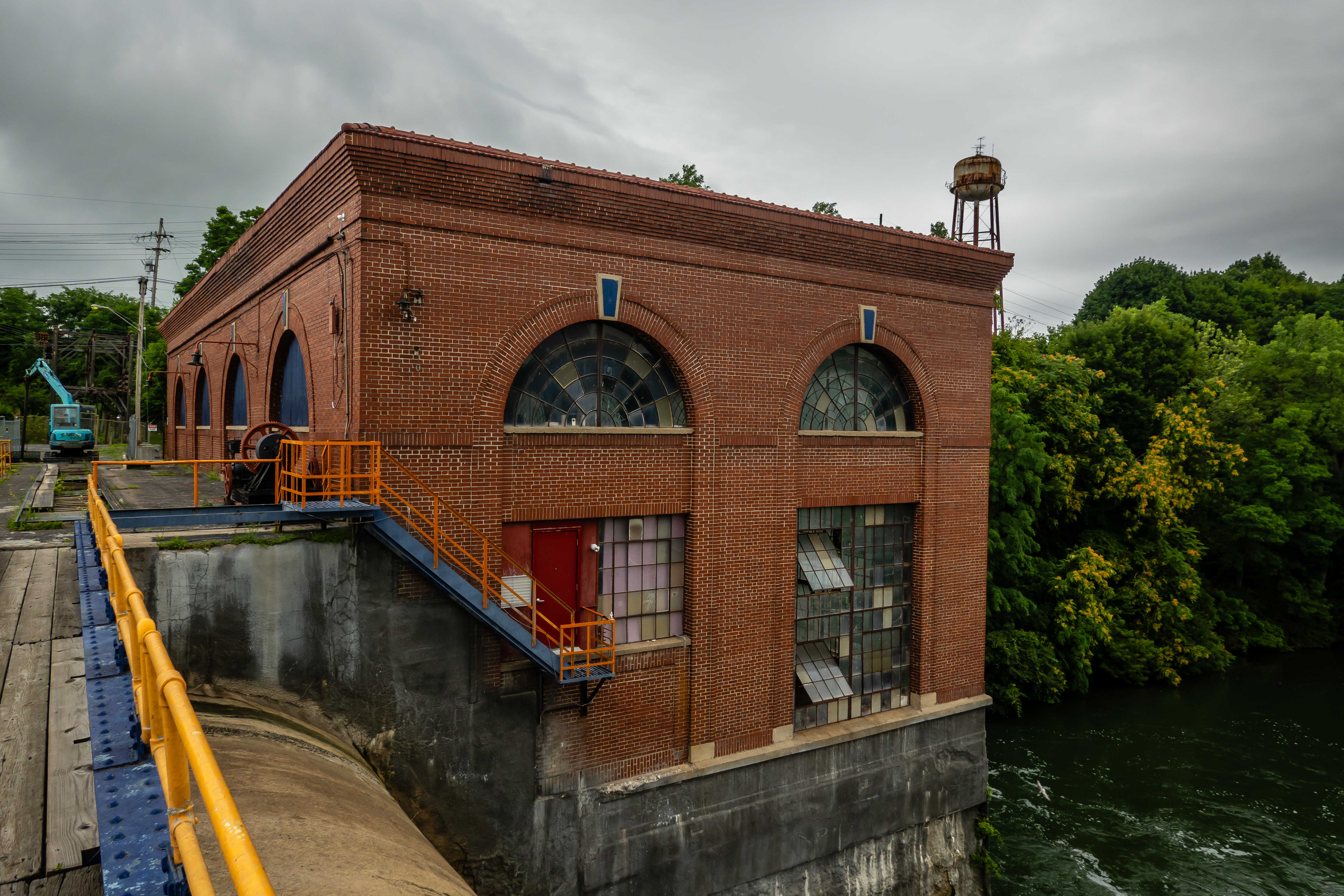
After the ranger talk was over, we saw we were very close to locks #2 & #3 on the Seneca Cayuga Canal so we decide to just walk down from the property to check it out. This one is pretty neat because it is a double lock - end to end, not side by side. This means the the two locks are able to share a set of gates, so there are only three sets. Each lock has a lift of 24.5 feet thus the combination provides a 49 foot lift. We didn’t get a chance to see a boat move through the locks but we could see one of the control panels the lock operator would use. There is another power plant at this set of locks just like there is at the one in Waterloo.
 |
| Approaching Locks #2 & #3 |
 |
| View from Bridge - Looking Upstream |
 |
| View from Bridge - Looking Downstream |
 |
| Power Plant |
 |
| Calm Reflections |
 |
| Control Panel for Locks |
The Adventure Lab we were doing had us stop at the National Women’s Hall of Fame but we didn’t feel the urge to go inside. We also made a quick stop near the “It’s a Wonderful Life” bridge to see some of the sculptures along the Ludovico Sculpture Trail.
 |
| Old Mill Converted into National Women's Hall of Fame |
 |
| Along the Sculpture Trail |
 |
| View from It's a Wonderful Life Bridge |
Next we head into downtown Seneca Falls to visit the buildings associated with the Women’s Right NHP. The visitor center has a couple of floors of displays and contains a lot of information. We spend 45 minutes wandering around before heading out to visit Wesleyan Chapel which was the site of that first women’s right convention. There is a small park between the two buildings that has bronze plaques with all the Declaration of Sentiments that were discussed at that first conference. The wall has a constant flow of water over the full 100 foot length and it appears to be perfectly level since the water flow was uniform over the full length.
 |
| Entrance to Women's Rights NHP |
 |
| Some of the Famous Players in the Movement |
 |
| Inside Wesleyan Chapel |
 |
| Wesleyan Chapel |