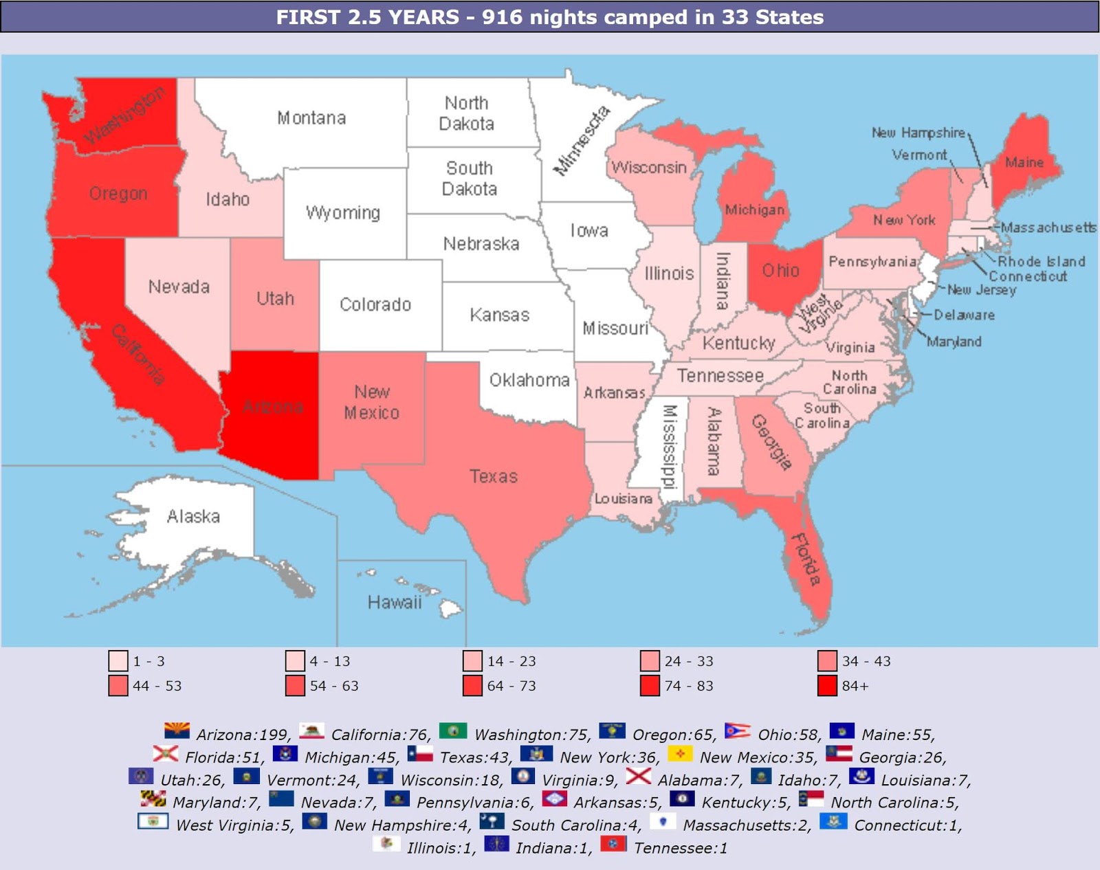
Map of this blog's locations click this link to open the map
I suspect that many people will envision the Florida Keys when we say we’re heading to Cedar Key Florida. While Cedar Key is a key, it’s not nearly as famous as the ones on the southern tip of the state. Cedar Key is over 300 miles north of Key West along the Gulf Coast. We had heard of the place from some fellow full time RVers and it had sounded interesting so we added it to our itinerary for the winter months in Florida. The plan is to stay for a month - most of December and a night into the new year. Sunset Isle RV Park is on the first of several small islands that make up Cedar Key. As an interesting aside, this stop will bring the number of nights we have camped on an island this year up to sixty! There was no premeditated goal to spend so much time on islands but that’s how it worked out.
When we pulled in on Sunday, the office was closed but there was a campground map with our name and site number circled. While I was unhitching the car out front, Chris wandered back to scope things out. A woman on a golf cart pulls up and asks for our name. When I told her, she mentioned that the site we were supposed to be in was still occupied but would go back and deal with it. The end result was to switch us to a different site which probably turned out to be a better scenario for us in the long run. The campground has about 15 sites that are waterfront. Ours is just up from those with a great view of the water from the front and side of our rig as long as the waterfront sites aren’t full. It looks like this will be a pretty laid back place. Every Friday evening is a potluck dinner followed by a music session with some of our more talented camping brethren. There will also be dinners on Christmas and New Years Eve.
 |
| Sunset Isle RV Park at Sunrise |
 |
| Our View at Rig |
Our biggest issue with staying here might be the limited number of geocaches in the area. To continue our cache a day streak, we will need to ration the 18 caches in an eight mile radius and plan on doing a few day trips to areas a bit further away. It was nice to be at a place for an extended length of time so that we could do a bit of online shopping that we have been wanting to do. For the first several days, we kept remembering something that we had been meaning to get and place an order. Over the first week or so, it seemed like we had never ending deliveries coming in.
A few miles back on the mainland is Cedar Key Scrub State Reserve. It is a 5000 acre park with 13 miles of multi-use trails. There are two sections to this park separated by County Road 347. We decided to take the mountain bikes to the western entrance off of CR 347 and see what the trails are like. We grabbed a map at the trailhead and started our journey. For the most part the trails are forest roads and were reasonably easy to navigate. The terrain is mostly flat with low scrub and a few larger trees. There were a few wet or muddy spots from the rains the day before and on occasion we were presented with sections that were completely submerged and we figured we didn’t want to attempt a crossing on the bikes in case it was muddy instead of just wet. Getting stuck in the middle of one of these could have been a mess so we would just turn back and try a different route. We eventually found our way around a loop and made it back to the trailhead. It isn’t clear whether the wet sections are always wet or just because of the recent rain. We might want to check it out again. Until we biked back to camp, we had gotten in a 12 mile ride.

 |
| Reflecting Pond |
 |
| Water Logged Trail |
 |
| Dry Trail |
A couple days later, we bike to the eastern entrance to Cedar Key Scrub off state route 24. The plan was to ride the trails to the west and come out on CR347. It turns out we should have followed the advice on the park’s website about not biking in the eastern portion of the park. The that section is mostly sugar sand which is so loose and deep that biking alternates between challenging and impossible. Based on the tire tracks, a truck had driven over the road not too many days ago, but not even those tracks were firm enough to bike on. If we had fat tire bikes, we may have been able to do better but our 2.1” tires were no match for the sand. As is was, there were a fair number of sections where the bikes were simply pushed through the deep sand. It didn’t help that they had recently bulldozed along the side of many of the roads probably to increase the fire break for a prescribed burn.
 |
| Sandy Trail |
The 5 or 6 miles seemed to take forever before we hit pavement again. On the ride back to camp I ended up having a flat rear tire. I inflated it in order to continue but that only lasted another tenth of a mile. Rather than fixing the flat on the side of the road, I simply walked the quarter mile back to camp. By then, my front tire was flat too. As I went to patch the tubes I discovered that each tube had FIVE punctures! The culprit was something called goats head. The dried seed head is maybe 1/8 inch diameter with several sharp spines jutting out in various orientations. I likely picked them up while riding in the preserve along the edge of the road but it wasn’t until I was on pavement that they got forced thru the tire and tube. I suspect if we had checked our tires and removed the goat heads, we would have avoided the flat tires. By the time I finished replacing my 2 tubes, I discovered both of Chris’ tires were flat as well. Only two punctures in both front and rear. She’s an underachiever!
 |
| Goats Head |
It’s only about a mile to get to “downtown” Cedar Key from our camp and the island itself isn’t very big. We find ourselves either walking or biking into town quite often during our stay. There is a small grocery store, a library, and even a hardware store. The large fishing pier always has some people out fishing but on some days it is quite crowded. The area also has lots of little shops, restaurants and a handful of bars. There is a fairly active boat dock. There also seems to be a huge number of birds down around the dock and the pier. Lots of pelicans, egrets and cormorants.
 |
| Downtown Cedar Key |
 |
| Birds Chillin' |
 |
| Xmas Decorations at Cedar Key Beach |
 |
| Fishing Artwork |
One morning the walk took us over to Cemetery Point Park. It would only be 2/3 mile on the water by boat but it works out to about 2.25 miles walking. On the way there, we pass by Cedar Key School. It looks like a fairly large school for such a small island but it turns out to cover the full grade range from prekindergarten all that way up to and through high school! It still seems to be too large a school to cover only Cedar Key. I suspect much of the surrounding area on the mainland uses this school as well. The park is located on a little bit of land jutting out into the water just behind the local cemetery. It can be accessed either by walking through the cemetery or following a quarter mile long boardwalk clearly marked by the park sign. There are several boats that have been strewn around the marshy area next to the boardwalk. They are probably the victim of some long gone storm or hurricane.
 |
| Boardwalk Entrance |
 |
| Bird at Low Tide |
 |
| Cemetery Point Park Beach |
 |
| Cedar Key School Mascot - SHARK! |
There are definitely a lot of the locals involved in the fishing business. The big products from the area are oysters and clams. Too bad neither of us are really into either of them except for a bowl of clam chowder. The boats that are used for clamming are rather interesting. First, the motor is mounted towards the front of the boat and the stern of the boat seems to be missing. Apparently clams are farmed and much of the work requires the crew to be out in the shallow waters either putting down bags of seed clams or bringing up mature clams at harvest time.
 |
| Clamming Boat |
 |
| Forward Mount Motor |
The name of the campground (Sunset Isle) is fitting given how the waterfront sites are on the western side of this small island. Nearly every night that is somewhat clear, many of the campers will come out to see how the night’s sunset is shaping up. We do seem to have a pretty good success rate with nice sunsets. Since the island we are on is fairly narrow, I only need to walk a quarter mile to watch the sun rise. I don’t make it out often except the one morning when I opened the shades and realized this sunrise looked special. I’m glad I ventured out for the photo.
 |
| Sunset |
 |
| Sunset |
 |
| Sunset |
 |
| Sunset |
 |
| Sunrise at Cedar Key |
Less than a mile from camp on the next small island towards town is the Railroad Trestle Nature Trail. The trail itself is only 1/3 mile long and ends at the water across from the back side of downtown Cedar Key. The bridge that used to take the train into town is long gone, although some of the old posts are still present in the water. The trail is nice with numerous interpretive signs along the way identifying all sorts of tree, shrubs and other plants.
 |
| Remaining Piers at Railroad Trestle Nature Trail |
 |
| Bird Sculpture |
 |
| Osprey |
Another nearby area worth exploring is the Lower Suwannee National Wildlife Refuge. It encompasses roughly the last 20 miles of the Suwannee River and the surrounding land. And yes, it is the river made famous by the old song. If you are like us, you’ll be surprised at the spelling of the river. Based on the Stephen Foster song, most would have expected it to be spelled Swanee. He apparently changed the spelling for the song. The Suwannee River starts in southeast Georgia and finishes its journey to the Gulf of Mexico within this refuge.
There is a 9 mile nature drive through the park. This drive has two access points the southern and northern entrances. The south entrance is just a little under 9 miles from the turnoff with State Route 24. We ended up coming to this place several times during our stay. Further up CR347 is the northern entrance to the nature trail and just beyond that is the main road into park headquarters as well as a parking area for several of the park’s trails at the northern end. Our first excursion to the refuge took us to the parking area on Headquarters Road. There is the 3/4 mile River Trail that is mostly a boardwalk out to a two level viewing platform overlooking the river. It was a nice spot but there wasn’t an abundance of wildlife around while we were there. Next we took the 2.5 mile Tram Ridge Trail. It was a nice enough trail and we had it all to ourselves but it probably could have been skipped without missing much.
 |
| Overlooking Suwannee River |
 |
| Butterfly |
 |
| Colorful Leaves |
Just off the parking area is the bat house. We had a bat house at our former home and was home to maybe 8 or 10 bats. This bat house is HUGE. It is estimated that 40,000 to 50,000 bats reside in the two houses! We will have to see if we can make it back here around sunset to watch the bats exit for their nightly feeding. We found it amusing that a sign is required to keep people from handling, rolling around in or consuming the guano beneath the house. Good thing for the sign since my first thought was to go roll around in bat guano!
 |
| Bat Houses |
Next we headed back out to the main road to head the half mile to the northern entrance to the nature drive. It is a dirt road but was in very good shape. Along most of the road are marshy areas with standing water. We spotted a fair number of herons but they tended to not allow us to get very close before gracefully flying away. Sporadically there would be higher ground and a locked gate to some forest road/trail. There are many miles of these extra trails within the park although only a few of them are mowed with the intention of them being true hiking trails. We stopped at the observation deck at mile 6.6 from the north entrance. There wasn’t much going on but it was a very pretty setting with a few ducks out looking for a meal. These little guys are very good divers and would disappear for much longer than we were expecting.
 |
| Overlooking Pond |
 |
| Duck Passes By |
 |
| Shaking it Off |
One of our day trips took us much further than we typically venture out. A few weeks ago, my laptop started to make noises. It has a solid state hard drive so I knew it wasn’t the drive failing. I took it apart to find the fan for the processor was failing. I found the thing on Amazon but it would be coming from China and would take at least a few weeks and has a several week arrival window. Since we could not guarantee where we would be when it arrived, we just had it sent to our mail service in Green Cove Springs figuring we would just forward it from there. By the time the fan arrived, the laptop’s fan had died so we figured we could just drive the 2 plus hours to our “home” and pick up the package along with the rest of our mail we had on hold.
The day we drove there was a very cold (for Florida) and windy one, but it was a nice enough drive and didn’t run into much traffic in Gainesville on our way there. We check out a small park in town that is the spring that gives Green Cove Springs its name. It turns out to be a sulphur spring so the smell wasn’t the greatest. The town swimming pool uses water from the spring before it flows out to the St Johns River. The park was all decked out for Christmas with probably 50 decorated Xmas trees. After exploring, we walked to a nearby Mexican restaurant for a tasty lunch before heading to our mail service to pick up our stuff. We spoke with one of the owners of the place about the recent changes to the requirements for voter registration and have that all sorted out.
 |
| THE Spring at Green Cove Spring |
 |
| Xmas Trees |
 |
| Spring Water Heading to River |
 |
| More Xmas Trees |
On the way back we stopped at Camp Blanding. We had spotted it along our route on the way out and Chris check the website to find there is a free museum just before entering the base. We figured we could stop and see what it had to offer. The two volunteers were both former military and had all sorts of stories to tell. We seemed to be the only visitors at the time so we got all of their attention. A video described the origins of the camp and how it was one of the major training facilities during WWII. It is currently the training facility for the Florida National Guard. We only had so much time before it closed so we didn’t get to check out the full museum building or outdoor displays. Maybe we will get a chance to stop since it’s not far from our home address. On the way back, we took advantage of the size of Gainesville and I got a haircut while Chris did some grocery shopping.
 |
| Machine Gun Display |
Another interesting place that’s only 8 miles from the campground is called Shell Mound. It’s a small historical site associated with the Lower Suwannee NWR. The area is right on the Gulf Coast and had been the home for native people over 4500 years ago. The claim to fame is based on the 28 foot tall mound of shells that make up a portion of the park. Admittedly, while the hill is apparent while on the 1/2 mile walking tour, the trees, brush and other plants make it difficult to identify it as a mound of shells. There is also a nice boardwalk area and the mile long Dennis Creek Trail that weaves through a salt marsh. We didn’t know what to expect and while it was nice, there really isn’t more than an hour or so needed to see the full thing.
 |
| At Shell Mound |
 |
| Boardwalk at Shell Mound |
 |
| Along Dennis Creek Trail |
Now that we have our Florida State Park Pass, we figure we should take advantage of it and head to Manatee Springs SP. It is roughly a 45 minute drive north near the town of Chiefland. We ask our neighbors from the campground if they would like to tag along and we head out with lunch in tow. The Jeep’s GPSr had some rather “creative” routing choices but we managed to find the proper entrance without its help. We head back to the long boardwalk that follows the water from Manatee Spring to the Suwannee River. The river is running high from recent rains up north of here so the water is rather murky. There may be manatees going by but we don’t see them. We do see a few turtles resting on a log and the occasional fish jumping out of the water, but there isn’t a huge wildlife presence.
 |
| High Water at Manatee Springs |
 |
| Kayak at Manatee Springs |
 |
| Turtles on Leaning Tree |
At the end of the boardwalk is a boat dock. It’s in this area where there are quite a large number of birds. A few of them are cormorants but there are nearly a hundred vultures - black vultures not turkey vultures. They seem to be everywhere. Some are circling far overhead. Some are sitting on the railings of the boardwalk and dock. But the vast majority of them are perched in trees on the opposite side of the spring’s channel. The ones on the railing are close enough to get some pretty detailed closeup pictures. They may not be the prettiest birds but I’m sure their mothers think they are cute!
 |
| Black Vulture |
 |
| A Face Only a Mother Could Love |
 |
| Cormorant |
 |
| Black Vultures Filling the Trees |
 |
| Cormorant Passes By |
We head back to the car to grab our lunches and find a picnic table to eat. Then we do a short walk to get a geocache. It was the first cache for Bert and Jeane. I suspect the experience wasn’t enough to convert them from muggles to cachers. As we headed back over towards the boardwalk to see if any manatees had shown up, one of the park volunteers pointed us in the direction of the spring telling us there were several in the clear water right at the spring’s outlet.
We headed around to the small swimming area on the opposite side of the spring to get a closer look. There were 5 or 6 of them. Most of them were large adults but there was one smaller one. They don’t really put on much of a show. They seem to just lay there under water until they need to get a breath and then surface only long enough to expel a breath and take another one. Given how many minutes they were staying submerged, it was pretty remarkable how quickly they surfaced and then settled back a few feet under the surface. The spring water is about 72 degrees and the relative warmth of the water is what attracts them to this place. As we head back from the manatees, we go past another pond area where two guys with scuba gear are emerging from a pond. Turns out this area has a rather extensive underwater cave system and they were just coming back from a lengthy exploration of the cave.
 |
| Several Manatees |
 |
| Manatee Surfaces Briefly |
 |
| Divers Emerge |
Having seen manatees, we feel accomplished and decide to head out. In the town of Chiefland is the Dakotah Winery. It wasn’t that far out of the way and the tastings are free so we figured there wasn’t really a downside to the trip. We sampled a large selection of wines although once we reached the sweeter ones and the desert wines, we stopped. We are much more dry wine aficionados. They did get each couple to buy some wine that we each liked. It was fun to go out with other people for our day trip. That seldom happens but we should make more of an effort to do it a bit more frequently.
The following day turned out to be a rainy one. There were no daytime hours when it wasn’t raining but I managed to go out for a geocache when it wasn’t pouring. I was glad I had saved some of the closer geocaches for a rainy day. When it was all said and done, the weather station at the local school had 6.31 inches of rain. There were several hours where the rate was over an inch an hour. It seemed like we were going to float away but other than some large puddles, we had no leaks and no real issue with what may have been the heaviest period of rain I have ever experienced.