Map of this blog's locations click this link to open the map
After five and a half months in Waterloo, it is time to start our journey south. The weather hasn’t gotten too cold in the Finger Lakes region, but we know it is only a matter of time. We have an appointment in Mocksville North Carolina in 9 nights to get our new window shades installed but other than that, we have no set reservations for the 700 or so miles between here and there. This is type of unplanned travel is where we find Elks Lodges work out well for us. In mapping out our trip south, we make Shenandoah National Park our first goal. There are lodges in the towns on the north and south ends of the park and we have stayed at both of them in 2018 also in late October. Back then, we hit a streak of rather cold weather and we only spent 2 nights at each lodge which really limited our chance to explore Shenandoah. This time, the weather forecast is looking much more promising so we were plan on spending a total of 7 nights between the Front Royal Virginia lodge and the Waynesboro Virginia lodge.
The direct route from Waterloo to Front Royal is about 360 miles but we modified the route to utilize two other Elks Lodges we have never visited before. It adds about 80 miles of travel but we think it should be a good choice. The first stop is at the Binghamton Lodge. It isn’t in the heart of Binghamton but rather in the small town of Kirkwood New York southeast of Binghamton about a 130 mile drive. We knew there was RV parking permitted here and they even have an outlet on a shed out back. We were expecting the lodge to be open based on the schedule but only one car was in the parking lot. An older gentleman came out to greet us and warned that they were having sewer issues in the lodge and a large hole in front of the shed was where they typically have visitors park. We explained we could deal without having electricity now that we have our updated solar/lithium battery setup. Since the lodge was closed for repairs, it was a quiet night.
Our next stop was going to be at the lodge near Harrisburg Pennsylvania pretty much 180 miles straight down Interstate 81. The West Shore Elks Lodge has a couple of RV spots and from postings on Facebook, seems to be a bit more frequented by traveling Elk. We pulled in on Saturday afternoon and find just one truck camper parked in the grass. This lodge has a member dedicated to running the RV spots - even though there are only two official spots. She asked if we had called ahead and we said nope. She informs us that there are two other rigs expected for the night and she didn’t have room for us even though it appeared there was what looked like more than enough room to fit us in a corner of the parking lot since we didn’t need to have a power or water connection. She told us she couldn’t spare the space since they were having bingo tonight.
So back out to rig to come up with plan B. The lodge in Hagerstown Maryland has one outlet but also has a huge parking lot that looks like we could easily dry camp in if needed. The only problem was it is another 75 miles down I-81. As we were getting ready to reconnect the Jeep to the motorhome, the woman comes back out and must of had a change of heart. She pointed to one corner of the parking lot and said if we could park there, we would be fine to spend the night. When the bingo crowd arrived, the parking lot was crowded but far from full so we weren’t bothering anyone.
We did discover an issue with the diesel burner on our hydronic heating system that evening. We weren’t going to need heat overnight but it’s the same system that heats our water and we knew that it would be a rather cold shower without it running. By then the other two rigs had shown up and I was able to run a long extension cord over to one of the open outlets which allowed us to heat the water using the electric elements. The next morning I went out to determine what was wrong with our system. I could tell the burner would initially light but not stay lit. I hadn’t done the service on the burner in quite some time. Since I had a service kit with us, I took the time to perform the maintenance. Unfortunately I also discovered that one of the fuel supply lines had a small crack in it and was leaking diesel inside the unit. As luck would have it, there was an auto parts store less than a quarter mile away. A quick walk to the store, and I was back with the proper tubing to fix the issue. When I was done, I fired up the burner and everything seemed to be working just like it should.
We headed to Front Royal Virginia on the northern end of Shenandoah National Park. It’s only a 132 mile drive - mostly on interstates 81 and 66. We knew the Elks Lodge there has one site with electric. Last time we visited, the site was already occupied so we were pleased when we pulled into the parking lot and found the spot open. But we made the mistake of parking on the other side of the lot to avoid the many cars showing up for some activity at the lodge. While we were unhooking the Jeep, another motorhome came in the back way and nabbed the RV spot. This forced us to find an open area of the upper parking lot which was starting to fill up for this lodge’s evening bingo. We can easily boondock a couple nights without a power connection so this should work out.
 |
| Thornton Gap Entrance to the Park |
The park is long and skinny with the 105 mile long Skyline Drive being the main road through the park along the ridge. Besides the entrances on the north and south end, there are two other entrances at roughly the 1/3 and 2/3 points along the drive. When we had last visited this area, we had explored the very northern third of Shenandoah National Park between Front Royal and Thornton Gap. This time we hoped to explore the middle of the park. We take the route on the east side of the park to come in at the Thornton Gap entrance station at mile marker 31.5 and head south through the park.
There is no shortage of hiking trails within the park - over 500 miles to choose from. We had investigated the hiking trails in the park and came up with a couple that seemed interesting. The first one wasn’t until mile marker 51 near the Big Meadows Visitor Center. This means we have about 20 miles of driving before we reach the trailhead. Of course there are at least 2 dozen overlooks in that distance. We realize if we stop at each one for even just a few minutes, we may never get our hikes in. It is hard to know which overlooks have the best views. Sometimes they are on the left with a view to the east side of the Appalachians and other times they are on the other side with a view to the west. We periodically stop as we work our way south.
 |
| Tunnel Parking Overlook View |
 |
| Pinnacles Overlook View |
 |
| Evergreen in Sea of Fall Colors |
 |
| Stony Man Overlook View |
 |
| Supposedly You Should See Stony Man |
 |
| Hemlock Springs Overlook View |
Around mile marker 42 was a place called Skyland. We weren’t sure what it actually was but decided to at least drive through the area. There is a large conference hall as well as numerous buildings with lodging as well as some small cabins - all for rent. It’s not clear if it is run by the park service or a concessioner but there appeared to be a fair number of people staying there. We parked and walked around a bit to check out the area. We saw a sign for the Massanutten Lodge so we headed up the hill to see this. Unfortunately it wasn’t open so we couldn’t get inside but it is a rather neat building built in 1911.
 |
| Skyland |
 |
| Massanutten Lodge |
 |
| Lodge from Below |
Continuing south on Skyline Drive, we stop at several more overlooks before we get to Big Meadows Visitor Center.
 |
| Crescent Rock Overlook View |
The Harry Byrd Visitor Center at mile marker 51 was a busy place. We head in to check out the displays and to stamp our National Park passport. There was a lot to learn about the history of the formation of this park. The view across Skyline Drive shows why the place is named big meadows. Even though the park is generally along a ridge line, this part of the ridge broadens out quite a bit. The fall colors were in full display.
 |
| Visitor Center at Big Meadows |
 |
| Some Shenandoah NP History |
 |
| View of the Big Meadows |
The hike we want to complete is the Dark Hollow Falls Trail. It is 1.6 mile out and back with almost 600 feet of elevation gain. Although like many of the hikes in this park, the first half is all downhill and we will need to make it up on the return trip. The trailhead is about a third mile north of the visitor center but we had noticed the parking lot was very full. Fortunately there is a connector trail that will get us to the trail with only the additional mileage. It is a pretty trail but fairly busy but it is a very nice fall day so maybe that should be expected.
 |
| Trail to Dark Hollow Falls |
The first 1/2 mile along Dark Hollow Falls Trail is along a creek but this creek is completely dry. It makes us question whether our timing was poor to see the falls. We ask a few people heading back up the hill if the falls were flowing and we were assured they were. It turns out the creek we were following connects up with another one that actually does have water flowing. There was a large group of people standing at the base of the falls and we almost needed to wait in line to get to a place where we could get a decent picture.
 |
| We Found Falls |
There wasn’t a sign near the falls and the trail continued down the hill with a great many people on this part of the trail as well, so we head further down and find another waterfall along the Rose River Loop Trail. Even though it was a pretty trail and looked to keep following the creek, we knew we had to make the hike back up the hill and still had another hike we hoped to complete, so we head back up.
 |
| Well Marked Trail Intersection |
 |
| More Falls |
 |
| Back Up the Stairs |
Our next hike was about 5 miles further south along Skyline Drive. We make a quick stop at another overlook along the drive. Bearfence Rock Scramble sounded really neat. It is only a 1.4 mile loop with just over 300 feet of elevation gain. It is unusual for this park in that this hike actually starts out going uphill. The only concern with the hike is the warning about not being good for people with fear of heights. We had even watched a YouTube video of the hike to get a sense of whether Chris would be able to handle the climbs and the ledges we would need to scale. She wasn’t positive, but we decided to give it a try. The trail starts off easy enough with steps leading out of the parking area.
 |
| The Point Overlook View |
 |
| Starting Out Bearfence Trail |
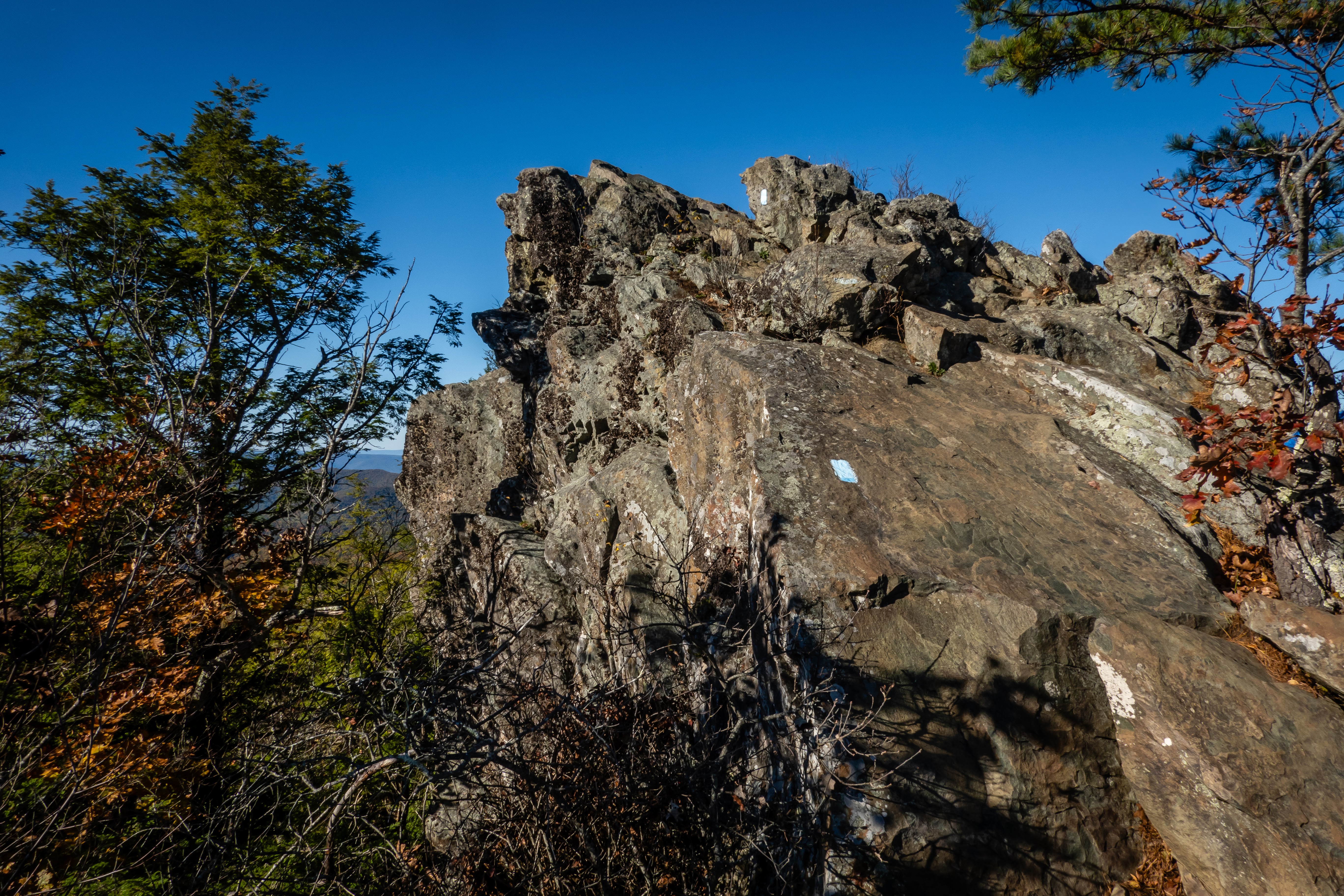
It doesn’t take long though before we hit the challenging part of the hike. The trail leads to a large rock outcropping. My first reaction is to look on either side to see if the trail goes around the rocks but it doesn’t. Then I notice the blue dashes painted on the rocks pointing out the intended path. This is similar to how the granite rock trails in Acadia NP in Maine are marked. So up we go.
 |
| Follow the Blue Marks on the Rocks |
The rock scramble portion is only about one quarter to one third mile long, but it is slow going. I take the lead to identify the path and get a feel for the level of scariness. Some of the sections are thru narrow crevices that make it difficult to contort the body to get beyond. The most important fact about this section is how solid the rock is. As I would test a handhold or foot location with my weight, I never found one to not be solid. The sure footing of the scramble definitely helps with the confidence as we head up.
 |
| Chris Works Her Way Past an Obstacle |
 |
| Narrow Crevice to Scale |
There was one section that may not have been particularly difficult from a climbing standpoint, but it was an exposed cliff with a pretty serious drop off to the right. I called back to Chris and told her to “not look to the right” when she got to this part or she would likely be turning around. When I got past that part, I was greeted with an astounding view of the surrounding mountains and the fall colors. Chris concentrated on the trail ahead of her and made it up as well.
 |
| Quite the View from Up Here |
 |
| Don't Look Down! |
We still had some uphill rock scramble to do to get to the top of Bearfence Mountain, but I think we were past the most difficult sections. There were quite a few people up here and we picked one of the many rocks to sit on to have a snack and enjoy the views.
 |
| Blue Marks Go That Way??? |
 |
| Another View Up Top |
After the break, we start our journey down. I suppose there are two options - continue to the south or backtrack the way we came. We didn’t know what to expect heading to the south but it was clear if we turned around, the one section with the exposed drop off would be hard to navigate going down. We find this portion of the trail to be pretty easy. There are spots where my longer legs were a big help in getting down some of the larger drops but Chris managed to slowly work her way down without too much trouble. The trail eventually intersects the Appalachian Trail and we have a relatively nice stroll back to the car. It was a beautiful hike, especially at this time of year with the colors.
 |
| Chris Wishes for Longer Legs |
 |
| The More Sane Appalachian Trail Back to Parking |
It is late afternoon by now and we are beat. We still have about 9 miles of driving on Skyline to get to the Swift Run Gap exit. There are plenty of overlooks but we don’t stop at very many of them. Coming out of the park going west, we realize that we will be traveling thru a couple of Virginia counties that we haven’t found a geocache in yet. We map out a route that will complete that mission and then head home.
 |
| Baldface Mountain Overlook View |
There is probably much more to see out of Front Royal but we decide to move on to the Waynesboro Elks Lodge at the south end of Shenandoah NP. We have stayed at this lodge as well back in 2018, but only for 2 nights. We hope to spend 5 nights there this time. We had conflicting reports as to whether they have a dump station, and since we already have 4 days worth of camping on our holding tanks, we decide to find a place to dump before we get to Waynesboro. The Front Royal water treatment facility has a dump that can be used but you must stop at the town hall to pay for it and get a receipt to show at the dump. Chris drives into town to pay and then we drive over separately, dump our holding tanks, hitch up the Jeep and head south. We make it to the lodge and find both of the two RV spots are available.
The next day, we head over to the Blue Ridge Parkway (BRP). We have explored a lot of this great 469 mile road through the mountains but predominantly in North Carolina. Milepost 0 is located just east of Waynesboro and is less than 10 miles from the lodge. Similar to Skyline Drive in Shenandoah National Park, the BRP has lots of pullouts with beautiful overlooks.
 |
| Northern Entrance to Blue Ridge Parkway |
 |
| Rockfish Valley Overlook View |
The Humpback Rocks Visitor Center is near milepost 6, so we stop here to get a map and some information about things to see and do in the northern portion of the BRP.
 |
| Visitor Center at Humpback Rocks |
It turns out there is much more than just the visitor center at this stop. The Mountain Farm depicts life in this area back in the 1890’s. There are numerous buildings including a cabin, root cellar and chicken house - complete with chickens. There is also a small demonstration garden although this isn’t the best time of the year for gardening. A ranger was in the area to help answer questions. It was a neat step back in time.
 |
| Rustic Chicken House |
 |
| Old Wooden Fence |
 |
| Cabin |
 |
| Garden with Scarecrow |
Continuing south along the BRP, we stop at the Greenstone Overlook (milepost 8.8). Besides the great view of the valley below, there is a quarter mile nature trail thru some woods and with some rock outcroppings.
 |
| Greenstone Overlook View |
Next stop at milepost 10.7 is Ravens Roost Overlook. This stop is quite interesting. Just off the parking area is a large open rocky area. You can walk around to get different views and get as close to the edge as you dare. It is a great spot to sit and relax.
 |
| Ravens Roost Overlook |
 |
| View of Valley Below |
 |
| View from Rock Outcropping |
 |
| Lonely Tree |
We next head to Reeds Gap at milepost 13.7 for a short hike along the Appalachian Trail. There is a 20 year old geocache hidden just off the trail about 3/4 mile from the parking area. While it is a relatively short hike to the south, it gains nearly 400 feet. It was a beautiful walk in the woods. We saw a few other people out enjoying the fall colors.
 |
| Heading Up Section of Appalachian Trail at Reeds Gap |
Another aspect of our day included working on some Adventure Labs along the BRP. There seems to be a series of these setup with each covering 20 mile sections of the parkway. We figured we could work on the first two which would take us thru milepost 40 and then exit 6 miles later at Humphreys Gap and work our way over to I-81 and head back to camp. We made it thru the first 8 stages of the first one but cell coverage is questionable along the parkway and once we had issues with the app, we were not able to get it to load during our drive. While trying to reconnect the app, we realized there was another Adventure Lab near the town of Vesuvius that sounded interesting. We knew with its proximity to the interstate and towns, we would have cell coverage there so we exited the BRP at milepost 27 at the Tye River Gap and head down the mountain into town.
Coming down this way had the advantage of getting into two other Virginia counties to find geocaches. One of the caches brought us to a small restaurant with a statue of a cow painted quite uniquely. Our true destination for coming this was to visit the McCormick Farm. While this place is less than a mile off of I-81/64, it isn’t the type of place we would have likely discovered on our own. The Adventure Lab and a geocache on the premises were what caught our eye and we are glad we noticed it. Cyrus McCormick was the inventor of the first mechanical grain reaper in 1831. His old home and outbuildings have been turned into a museum that is free and open to the public daily.
 |
| Cow Art |
 |
| Slave Cabin at McCormick Farm |
It is a very pretty setting with a large pond and is surrounded by active farmland. There are multiple buildings including the family home, gristmill, and workshop where the reaper was developed. Several of the buildings are open with numerous displays. We are suckers for this type of things and find ourselves spending a lot of time wandering around and reading about farming and farm machinery. This day didn’t go like we initially planned but likely turned out better than planned. Once done here, it was a relatively easy drive back up to home.
 |
| Grist Mill |
 |
| Reaper Displays |
 |
| Workshop |
 |
| Large Water Wheel for Mill |
We were still having very nice weather so we plan to head into Shenandoah NP. Having done the northern two thirds of the park out of Front Royal, that left us with the southern third. But when we visited the park back in 2018, we had done some nice hikes in the southernmost 15 miles of Skyline Drive. With that in mind, we investigated hikes between the Swift Run Gap entrance (MP 65.5) and milepost 90 and came up with a hike along the Appalachian Trail to Hightop Peak.
There are two parking options along Skyline Drive for this hike. We pick the small parking lot at Smith Roach Gap (MP 68.5) with the plan of hiking the AT towards the north to Hightop Peak. This hike will be about 3.5 miles and gain just under 1000 feet. This option is actually longer and has more elevation gain than the parking area north of the peak, but there is a fire road that parallels the AT between the parking area and about 1 mile up the trail that can be used to add some variety to the hike. We pull in to a nearly empty parking lot and head up the trail.
 |
| Starting Up the AT at Smith Roach Gap |
 |
| More Uphill Trail with Large Rocks |
It is a beautiful hike although it is a fairly steep grade. We take it slow and enjoy the scenery as we work our way up to the peak. Once we get to the top and see the view, we know it was worth all the effort.
 |
| Vibrant Oak Leaves |
 |
| Fungus |
 |
| View from Hightop Peak |
As we come back down the AT, we see a sign for a camping hut. It looks to be well under a quarter mile out of the way, so we go to check it out. I was impressed. It was bigger and nicer than I expected. No thru campers were there, so we sat down at the picnic table and had a snack before heading out.
 |
| Hightop Shelter |
 |
| Watch Out for Smelly Hikers! |
The fire road I mentioned earlier is actually a service road for this hut so we were able to simply hike down the road, cross the AT and continue to the parking lot. This route is a bit longer and there were some steep sections with a lot of gravel which made for unsure footing. It was an okay return trip but in hindsight, we should have just retraced our steps down the AT.
 |
| Fall Flowers |
 |
| Colorful Trees Along Fire Trail |
 |
| Seeds Ready to Fly |
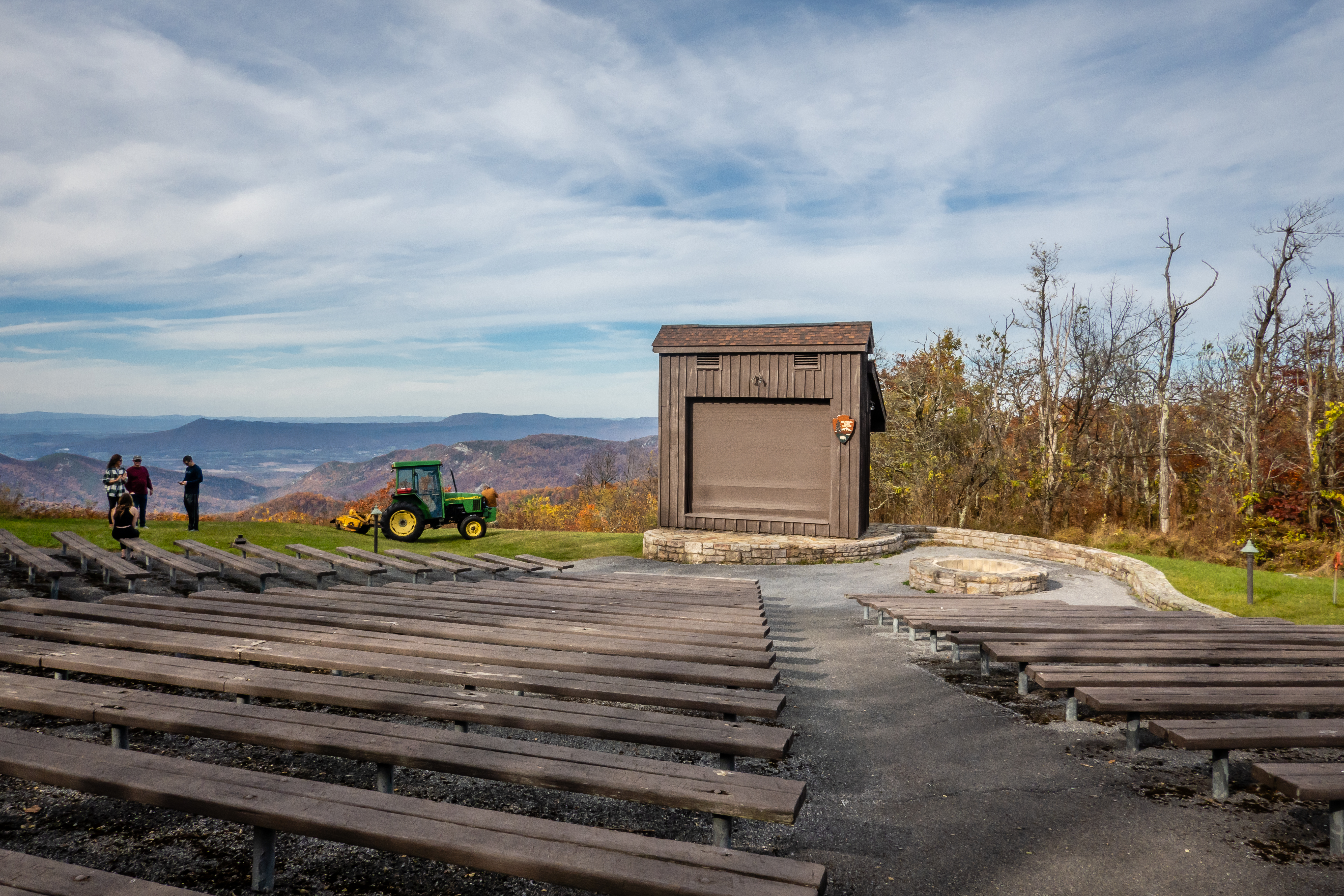
As we continue the drive to the south on Skyline, we stop at a couple more overlooks before we visit the Loft Mountain Gift Shop. While Chris was searching for a t-shirt, I noticed there was a very old virtual cache near the Appalachian Trail at the campground just across the road. We head in towards the campground and park at the large amphitheater lot to start our half mile walk to the cache. We have seen some pretty nice amphitheater settings and this one is near the top of the list.
 |
| Loft Mountain Overlook View |
 |
| Two Mile Run Overlook View |
 |
| Amphitheater at Loft Mountain Campground |
It is 3:30 PM by now and it’s been a long day. We have roughly 25 more miles of Skyline Drive to travel before we even exit the park. We decide to limit the number of overlook stops along the way or we may never get out of there. We’ve now traveled the length of Shenandoah NP and saw a lot of it but realize we likely just scratched the surface.
 |
| Doyles River Overlook View |
 |
| Trayfoot Mountain Overlook View |
We had read about something called the Blue Ridge Tunnel in Waynesboro and decided it might be fun to walk thru a 0.81 mile long old railroad tunnel. As we pulled into the parking area, there were signs explaining it was closed for a private event later in the day. Turns out they were having some sort of Halloween party given by a local brewery. Too bad it was sold out because that sounds like even more fun! So now we needed a plan B.
There are a couple of Adventure Labs in downtown Waynesboro so we drive to a parking area near the South River Greenway to use one of them as a tour guide of the river trail. This one did a nice job of explaining the history of the area. It was a reasonably nice day and there were plenty of people enjoying the trail besides us. The South River seems to be a very popular for fishing. We saw lots of guys with waders and fly fishing rods trying to get lucky.
 |
| South River in Waynesboro |
 |
| Big Mural |
 |
| Fishing Themed Art |
At one point, an older guy walking in the other direction said hi and started talking with us. He was a really interesting guy that was born and raised in the area and was a mailman for most of his career in the neighborhood near the river. He had all sorts of stories and for some reason we likely stood there and talked with him for twenty minutes or more. We did say we were looking to learn about the area and we found a personalized local historian. As we walked back to the car, we saw the parking lot was nearly full now. There must have been some sort of Halloween party for kids downtown because every way we looked were young kids in some sort of costume.
 |
| Another River View |
 |
| Old Factory |
The next morning we head back to the Blue Ridge Tunnel. There are two parking areas to access the 0.81 mile long tunnel. The west trailhead has fewer parking spaces and requires a fairly steep downhill walk of 3/4 miles before reaching the tunnel entrance. We opt for the east trailhead which has over 50 parking spots. It still requires about a 3/4 mile hike to the tunnel entrance, but the trail is relatively flat and in good condition. The tunnel itself was built in the 1850’s but wasn’t converted into a public walking trail and destination for visitors until 2020. I guess that is why we were unaware of this when we last visited in 2018. The old Afton train station is still standing but is actually a private building.
 |
| Former Afton Train Station |
The tunnel has no lighting except for the little light coming in from either end so a flashlight is a requirement. The tunnel is straight enough that you can see the other end of the tunnel for the full trip of that helps with your claustrophobia. The other things to be aware of is the environment inside the tunnel. The tunnel is 720 feet below the top of Scott Mountain which it cuts through. Expect the temperature to be in the low to mid 50’s and there is a good chance you will come across puddle and possibly even get drops of water from the ceiling above. It was a pretty walk to the tunnel and we even had a geocache to look for prior to entering. Finding this one was a bit of a challenge with so many other people around.
 |
| Starting Out the Trail |
 |
| Tunnel Ahead |
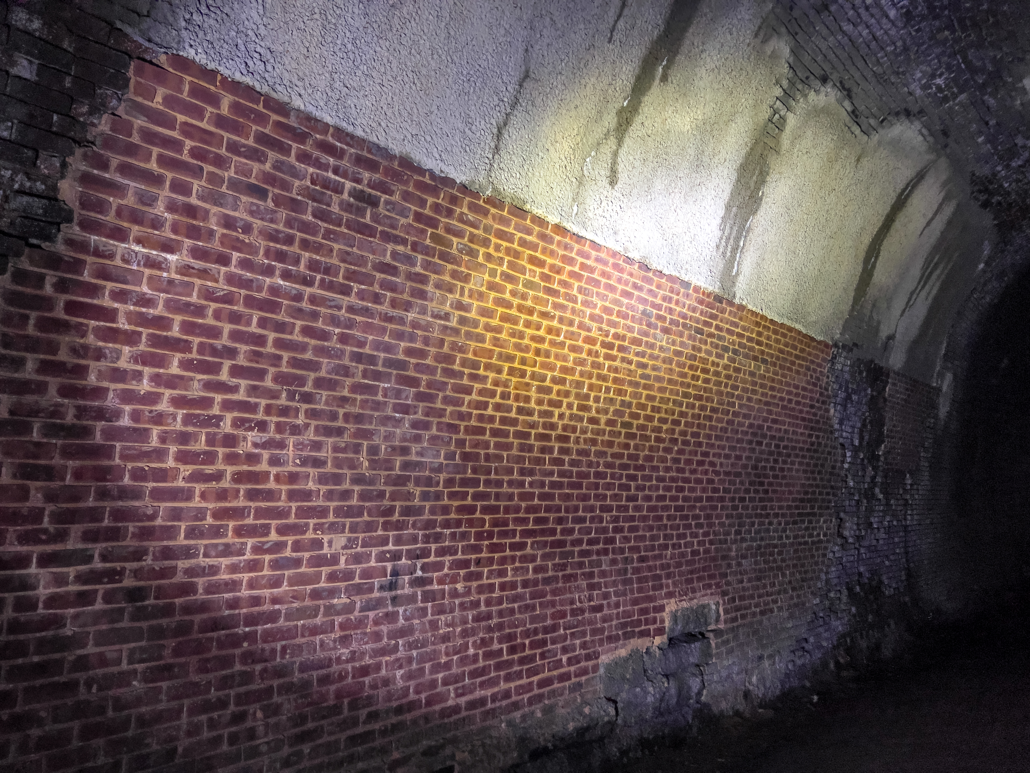
The walk thru the tunnel was quite interesting. Some sections have just the bare rock exposed while other parts are lined with brick. The bricks likely were needed in portions with more crumbly rocks to prevent debris from falling.
 |
| Brick Section |
 |
| Bricks Overhead |
Back in the 1950’s, a company planned on using the tunnel for storing propane. Two concrete bulkheads 10 feet thick were constructed in the middle of the tunnel. Propane was never stored inside, but the bulkheads remained in place until the effort to convert the tunnel into a destination walk had them removed. There is still evidence of where these barriers were as we walk thru the tunnel. One section of the tunnel didn’t just have water dripping in but a rather serious stream.
 |
| Old Bulkhead Section |
 |
| Newer Brick |
 |
| Steady Stream of Water |
It takes some time for the eyes to adjust to the bright sunshine when we exit on the west side. We saw no reason to hike up the hill to the other trailhead but we did walk far enough to find the geocache hidden on this side of the tunnel.
 |
| Western Entrance |
 |
| Off for a Geocache |
 |
| Heading Back In |
We head back into the dark to experience the cool weather and get one last look of the Blue Ridge tunnel. It’s hard to believe that above our heads is Skyline Drive, US Route 250 and even Interstate 64. Of course when the tunnel was being built, none of those roads even existed.
 |
| Spooky Feeling |
The five nights we spent in Waynesboro went very quickly. If we didn’t have an appointment to get some window shades installed on the motorhome in Mocksville North Caroline, I think we would have been inclined to stay longer.