Wednesday, August 31, 2016

More Day Trips Out of St Ignace

Map of this blog's locations click this link to open the map

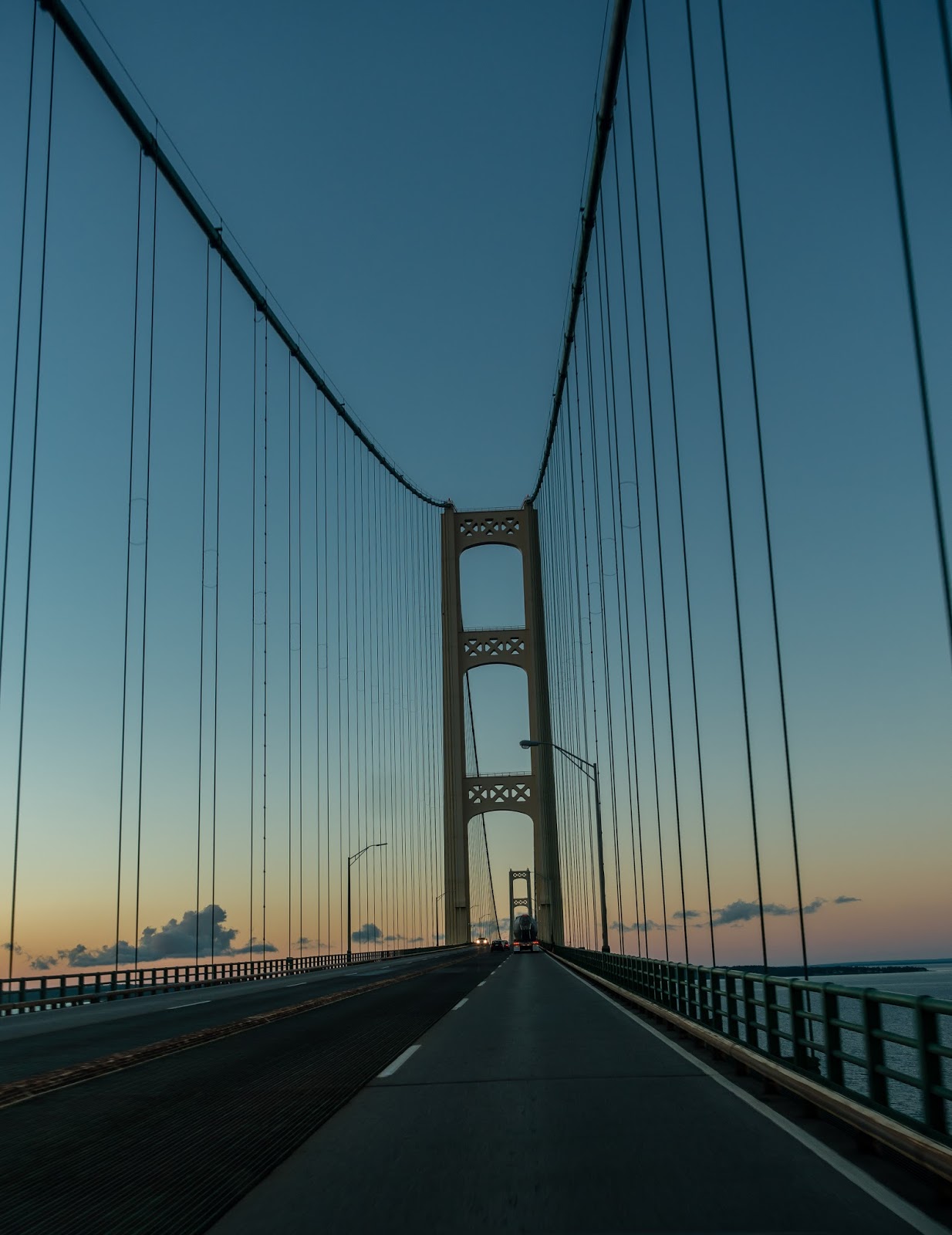
We finally decided to head across the Might Mac and check out some of the northern lower peninsula of Michigan. Mackinaw City is right across the bridge and there are many interesting sights at the water's edge.
The Mighty Mac
A Freighter Coming Through
The first attraction is Fort Michilimackinac. This is an old fort that has been (is being) restored. We looked around the gift shop a bit but decided we weren't in a mood for a history lesson today.  The park adjacent to the fort includes Old Mackinac Point Lighthouse. This is a pretty and well maintained lighthouse that is no longer in use other than as a tourist attraction.


We continued walking along the beach and then sidewalks all the way into the main portion of Mackinaw City. There are some very beautiful homes right on the water on the "Tip of the Mitt" as this place is also called. Surprisingly there were small little parks every block or so allowing access to the water and usually a great view of the bridge.

A Different View
Besides all the ferry terminals to give passage to Mackinac Island, there is a rather large marina and at one of the piers was a rather impressive looking boat. The US Coast Guard Icebreaker Mackinaw is docked there and since it isn't really needed in August, they sell tickets to tour the boat. We skipped this tour but did read about this boat. The ice breaking portion has a hull 1 5/8 inches thick and even has special rudder to permit it to break ice in reverse if it ends up getting stuck.
Icebreaker Taking a Break
We stopped for a great lunch of fish and chips at an old railroad station, right next to a large set of specialty shops. The Lego store was cool but decided the memory of playing with them as a kid would have to suffice.

Next we headed west of town to the another lighthouse. McGulpin Point Lighthouse was smaller than the other but was run completely by volunteers. The complete house was open to tour and was very nicely decorated as it would have been when in use many decades ago. This even included life size figures of the light keeper and his family which was only a little creepy when you aren't expecting somebody to be standing around the next corner.
McGulpin Point Lighthouse
You are also permitted to climb the tower and if you can crawl through the short hatch, you can go out onto the catwalk around the top. The view is very nice looking over the straits and the Mackinaw Bridge in the distance. A few geocaches were scattered about the property. But along all the well groomed trails are lots of interpretive signs with life size glossy color cutouts of various people associated with life here in the past.
View of Straits from McGulpin Point

From McGulpin Point
Just a couple miles south of this lighthouse is Headlands International Dark Sky Park. Since I have recently gotten into night sky photography, I wanted to check this place out during the day in case I want to come back some evening. Some of the property is closed due to the construction of what looks like a good size observatory being built. After the construction is complete, it might be worth another look on some other trip, but the setup in Pennsylvania at Cherry Springs State Park, another dark sky park, seemed more comprehensive.
Observatory Under Construction
Most the the areas we walked were right along the water line of Trails End Bay. At one point we noticed a flower that years ago we had found on our property - Fringed Gentian. When I had found it back home, I had picked one to bring up to the house to check our books, only to discover it is quite rare. Oops! Walking along the beach here, I doubt I could have convinced anybody that this flower is rare since it was growing everywhere along the paths we were on.
Fringed Gentian
Grass-of-Parnassus
We then headed back to Old Mackinac Point Lighthouse for sunset. The clouds were not cooperating very well to produce a sky with much interest but the lighting on the building was still pretty good.
Setting Sunlight on Old Mackinac
Some Clouds to the East of Lighthouse

The sun was just setting as we drove back across the Mackinaw Bridge. Chris drove so I could attempt some photos.

Setting Sun from the Bridge

Close to the First Tower
Another trip took us just north of town to a place right next to I-75. In fact it is hard to miss as you drive by. Castle Rock is a 109 foot tall chunk of rock that juts up over the expressway giving a great view in all directions. There is a souvenir shop at the parking lot with loads of your typical crap as well as all sorts of rocks - non of which really seemed to have any connection with the limestone formation right outside the door. Another oddity was the huge statue of Paul Bunyan and his blue ox Babe. Not clear why he is here other than to summon travelers to stop.
Closeup of Castle Rock from Below
Babe, Paul and Castle Rock
In a manner that is almost like a throwback to my childhood, it will set each person back exactly $1.00 to get to the stairs so you can climb to the top of the rock and onto the platform precariously mounted on top of the rock. Once up there and after caching your breath, the views are great although Chris seemed unwilling to get too close to the edge even though there is a fence surrounding the platform.
View from Castle Rock
Overlooking I-75
Don't Look Down Chris!
The Stairs had a Substantial Slope Left to Right
She Cannot Quite Pet Babe's Head

One remaining day trip was to the north east of St Ignace across Route 134 to the town of Cedarville with several stops along the way. The first side trip was down to Search Bay. The road there, if you want to call it that, was a good excuse to have the Jeep as our sightseeing vehicle rather than a sport car. Along the bay are a few primitive campsites and at one of them was a tiny old travel trailer somebody had managed to pull there.
View of Search Bay
We got out at Search Bay Nature Preserve with the intent of hiking to a couple geocaches nearly 1/2 mile away but on what appears to be a non-existent trail. We weren't in the mood for a bushwhacking walk so we passed. We did however discover another bumper crop of Fringed Gentian all along the shoreline. Apparently this area is great habitat for these "rare" flowers.


Ducks Taking Off After Chris Scares Them
Next stop was the Birge Nature Preserve. This place at least had a paved road and a small parking area with a nice trail and boardwalk back to an observation platform overlooking Loon Lake. Yet again of a place we likely would have missed except for a geocache calling to us to check it out. It was very peaceful back there and likely could have sat there for hours without seeing another human being.

View of Loon Lake
Tree with Unknown Growth 
Next stop Mackinaw Bay Nature Preserve. There is a decent observation platform but the view is of some tall shrub like plant growing well above head level obscuring any hope of a view. In the small town of Cedarville, we found a pizza joint with a very talkative owner and since we were his only customers, we got all his attention. But the pizza was very good and he gave us some excellent bread before the pizza arrived. So we had plenty of leftovers for another day.

Our last stop was Derby Nature Preserve. Okay, we had not set out this morning and challenged ourselves to see how many "nature preserves" we could see in a day, but it sure seems like that was our goal. There was a nice trail system in this preserve and since it was adjacent to some of the islands where many rich people live in the summer (at least according to the pizza man), these trails were well marked and maintained. The bench at the end of one trail overlooking a couple island with some expensive looking home was quite the nice setting.
Houses on One of Many Islands in Area
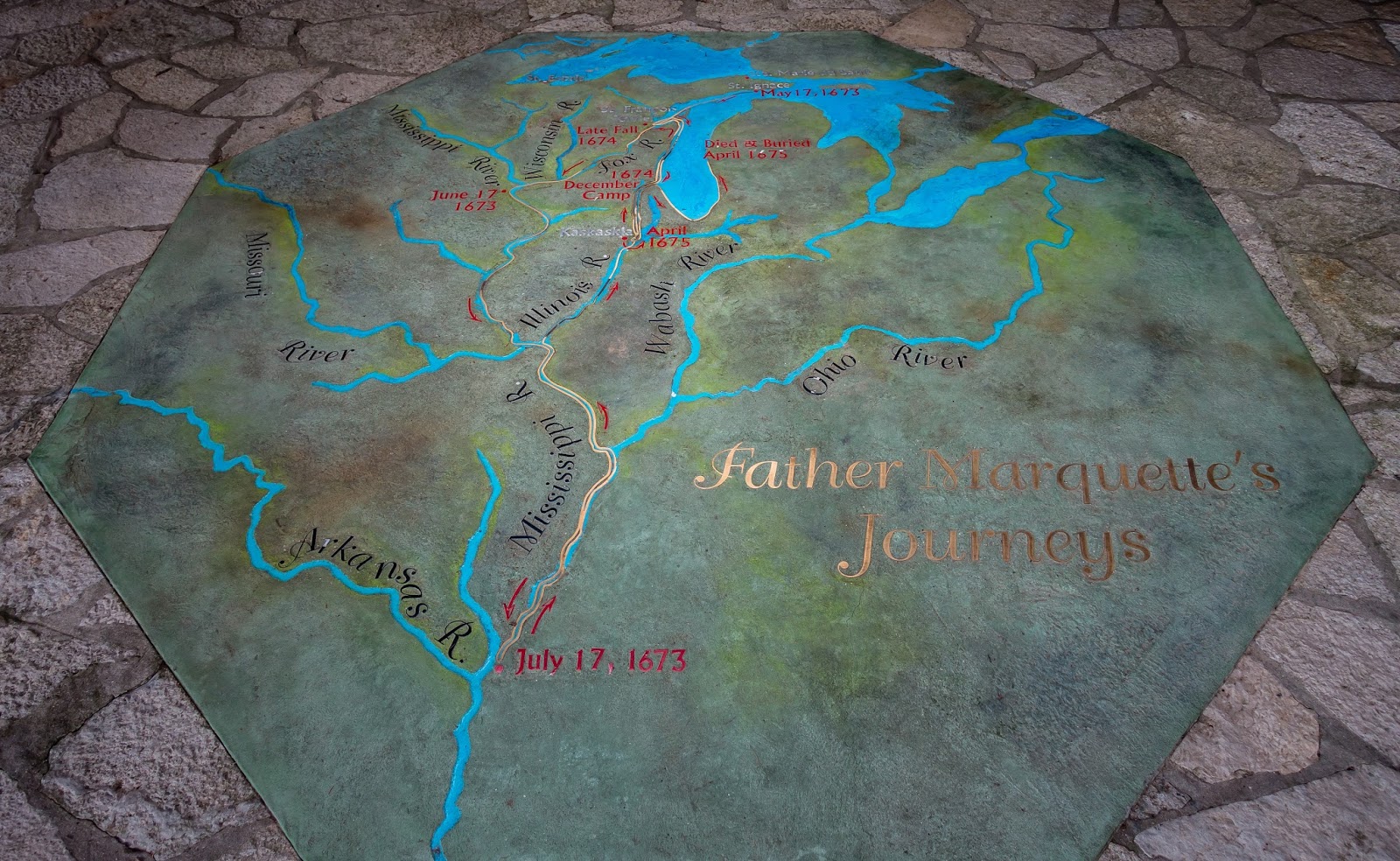
And finally on our last full day in this area, we went to the two parks just on the other side of I-75. Father Marquette National Memorial had some interesting. Displays talking about the explorer and missionary that visited and explored this and many areas centuries ago. There are also some trails to overlooks of the Mighty Mac.
Father Marquette's Journeys Floor Mosaic
Another View from West of Bridge
Ominous Clouds Over Lower Peninsula
Just below is another park at water's edge called appropriately enough Bridge View Park. We sat on the bench and watched traffic coming and going over the bridge. We weren't at the park more than 20 minutes but in that time we saw a state trooper pull over two different semis and even had the one back up the road and through the toll booth lanes! Hope we don't do what he did when we take the motor home across.


Tuesday, August 30, 2016

Two Months on the Road

Camping stops during first two months click this link to open the map

August 29 was the completion of our first 2 months on the road. And since I still think like an engineer, I guess I will start the summary with a list of the facts. Plus we have had several friends and strangers ask us these types of questions.
  • We have been in the rig 62 nights.
  • We have stayed at 7 campgrounds for multiple nights and had 5 overnight stays at places like Walmart and Cabela's as we travel longer distances between destinations.
  • We have done 1650 miles with the motorhome.
  • The diesel fuel motor home is costing us $0.26 per mile.
  • We are averaging $27 per day in camping fees.
  • On the days we drive the motor home, we have averaged 138 miles per day.
  • We have put just about 3000 miles on the Jeep doing all our sightseeing trips.
There really weren't any surprises in the numbers. Having traveled a lot over the past 6 years, this is about what we were typically doing with the possible exception of our length of time we stay at one campground is a bit longer than we used to do. When we started out on this adventure, one of our goals was to slow down and stick in a place longer than just a couple days or so. We actually hope to stay put for even longer than this in the future, but we have a fixed end date for this first part of our travels so this schedule and pace is just how it works out.

It seems like we are in tourist mode 85% of the time and normal life mode the remaining 15%  That might be the one thing that seems a bit skewed. Not that it takes more than 15% to handle the mundane life activities, but it seems like trying to be in tourist mode for that long gets tiring. I used to joke when I was still working, that I needed to go back to work after a long vacation in order to rest up! These first two months have been very fun but admittedly tiring at times.

What have we learned that we didn't know before. For one thing, we are easily able to stay at campgrounds without full hookups for 10 days without any holding (fresh, black or grey) tank problems. Admittedly we have been at some places with reasonably nice facilities so we don't mind showering there especially mid-week when it isn't crowded. And Chris has not exclusively done laundry in the rig but went to laundromats occasionally. 

We miss having off the air television choices but probably not enough to go with some sort of satellite receiver (there's already a dish on the roof). While in the Upper Peninsula there were quite many spots where we had no choices, or the channel we got would come and go randomly. We even discovered the LED bulbs we put in much of the coach's interior lights can interfere with TV reception in low signal areas. Normally I don't care which network we get, as long as we can get the evening news at times. But we missed all the Olympics because we didn't get NBC where we were those weeks. Pretty sure this is the first time I saw no Olympic events broadcast.

Worse than not having television, we went 9 nights at a campground without any Verizon signal. Not positive if we had some sort of booster we would have had better luck or not. Maybe AT&T would have been better? But Chris hasn't added this to her iPad yet but the thinking is to go that route to give us a backup plan if we hit areas where one is better than the other.

For the most part, we have started to get used to where things are stored and only occasionally search for things that might be hidden in some box or container stashed away in some seldom accessed cabinet. I finally found the HDMI cable I was sure I had brought before going and buying a new one. I guess that is one nice thing about living in a few hundred square feet versus 2800 square feet - there are not nearly as many hiding spots!

There haven't been too many things we feel we are lacking with the obvious exception of our dog Shelby. I cannot say that we really miss owning the house or all our stuff. In fact I suspect that there will be some things that we brought along that we will agree we really don't need and can part with at some future date.

There may still be a bit of apprehension about wandering aimlessly. After the wedding in Cincinnati, we are thinking of heading towards Washington DC. I have never been there other than to drive by on some business trip and Chris was there years ago with her mom on a vacation for a week. After that there is no plan except to head towards Florida to deal with the paperwork required to become residents there.

Summary: We are enjoying this phase and have no regrets about going thru the downsizing to get here.

Friday, August 26, 2016

Day Trips to Mackinac Island

Map of this blog's locations click this link to open the map

One of destination spots for this area is Mackinac Island. Okay, its probably THE tourist destination for anyone traveling through here. Unlike the boat tour out of Munising to see Pictured Rock where there is only one company to pick from, there are several to choose that run a ferry service from either St Ignace or Mackinaw City out to Mackinac Island. We picked Arnold Transit because they had a package deal where you could use the ferry as much as you liked on two consecutive days. It wasn't clear why somebody would make the round trip more than once a day. Sixty six bucks got us and our bicycles passage for the two days.

We carefully watched the weather forecast and decided on a Thursday and Friday. The Arnold terminal is only about 2 miles or so from the campground and it's more or less downhill the whole way - a fact we regretted each day when we bike back to camp. Turns out part of the reason this ferry was cheaper was their boats are slower and also seem to be the cargo boat for all manner of supplies to and from the island. In fact the ferry we caught over on Friday was a little late leaving because they needed to unload a dozen horses into two big horse trailers.

Ferry Horses
Our boat ride is only 35 minutes so the fact that Star Line Ferry does it in about 20 minutes didn't matter much, but they do have Hydro-Jets that send a plume of water out the back of the boat. They are pretty cool looking but probably not worth the 2X price.
The Ferry NOT Taken
The ferry ride gets you a different perspective of the Mackinaw Bridge and also brings you past the pretty Round Island Light House. There are some also good views of the west and south sides of Mackinac Island
Leaving St Ignace
Approaching Mackinac Island
Navigation Aid into Island Marina
Round Island Lighthouse
Breakwall with Mackinaw Bridge in Background
We decided to use our first day here to more or less get a lay of the land. Since no vehicles are permitted here, walking, bicycling, or horse drawn carriage are your choices. The "road" that goes around the perimeter of the island is just over 8 miles long and being at water's edge, is mostly flat. So it wasn't out of question to see some people simply walking the loop.

The boat docks are on the south end of the island as are the majority of the shops. It was quite crowded in this area so we decided to bike around the perimeter first, stopping along the way to see some of the views and also do the required tourist stops. Mission Point Resort had many Adirondack chairs out but nobody enjoying them this morning.

Mission Point Resort
Arch Rock had a very big crowd, so big it was hard to find spots in the bike rack. It can be viewed from below or above. There is a staircase up the bluff to get to the viewing spot. The park is good enough to let you know it is 207 steps to the top.
Arch Rock from Up High
A Couple Trees Hanging On
Arch Rock from Below
At the north end of the island is British Landing. There are restrooms, a small nature exhibit, and a concession building. It gets crowded here too. One thing we noticed about  an area with this many people riding bikes, you really must pay attention since people don't tend to look where they are going. Going slowly and having hands on the brake levers at all times probably saved us a couple times.

We got back in town and found a place to park the bikes and join the crowds. We were hungry for lunch by then. The place we picked was good but overpriced. Maybe not too unexpected for a captive audience in a huge tourist destination. After lunch we walked around town a bit checking out the sights. There are lots of pretty homes.

Maybe My Favorite
Pretty Gate


The pretty little park was inviting with a great view of the water, but you are only "invited" to use it if you by some overpriced dog or burger. Being full, we passed.


Kites Flying
One thing you don't really get used to is the smell of the horses or more specifically their poop. The town has guys trying to keep up with the mess, but it's a never ending job. Now there's a shitty job if I ever saw one. The horses for the Grand Hotel carriage were decked out in a bit of a costume trying to look more regal I suppose.

Even the mail and package delivery is by horse drawn carts. It was just a bit odd to see Amazon Prime packages sitting on the cart. Curious if the 2 day promise works here as well?

Package Delivery

View Up the Street
Fort Mackinac was neat looking. We didn't actually go thru the thing but it does have a nice view from up high. Every now and then they fire off a real cannon that seemed to scare us each time.
Fort Mackinac Overlooking Park

We decided to walk up to see the Grand Hotel. If you aren't staying at the hotel, they allow you to pay $10 per person for the privilege of checking it out. We assumed this meant to see the inside so we walked up the sidewalk and got to the front entrance only to be yelled at by a woman on the entry porch asking where our visitor pass was. We turned around and headed back only to see another woman collecting money from people a hundred feet back from where we got to. We aren't sure how she missed us on our way by the first time. The stone church just down from the hotel was quite picturesque.

Front of Grand Hotel
Water View of Grand Hotel
Stone Chapel

A Turtle's Nightmare
We hopped back on our bikes and made the climb up the hill past the fort back towards a golf course and the more rural portions of the island. It was here that we saw a huge barn that apparently is one of the Grand Hotel's for their carriages and horses.
Beautiful Stable

We did a few geocaches back off some of the gravel and dirt trails and saw several groups of people touring around on horseback. Now we knew where we wanted to head when we came back the second day. We caught the 5 PM ferry back and got ready for our return visit.

We were anxious to come back, but not enough to catch the 7 AM ferry, so we stuck with the 9 AM. We knew the approach to the trails we wanted to ride would be easier from the north end so we headed up the perimeter trail to British Landing in a clockwise direction. This also worked out well because not as many people seemed to be heading this way.

We found the approach to Tranquil Bluff trail was pretty good, but the trail was definitely a technical, narrow single track with lots of roots, rocks and the chance of going over the bluff! The upside was there were plenty of trees along the bluff that would prevent you from falling far. We only saw two other people - a jogger and a photographer.

The next trail was Swamp Trail which was a little wider but was labeled a horse jumping trail with the most difficult rating. It turned out to not be bad since at each jump, there is a little loop  that bypasses the jump. We eventually made it to Leslie Ave which was actually a paved trail. At one of of the overlooks, we decided to sit down and have our lunch with a view. By then we already had found 20 geocaches.
Well Marked Trail Entrance

Our View for Lunch
There were a few more lesser visited destinations in this area of the island. The first was a rock formation known as Sugarloaf - a 75 foot tall chunk of limestone. Then over to the area of the airport to see the Cave of the Woods and the Crack-in-the-Island.  Neither were that special but worth the look if you're in the area. We eventually made our way back to British Landing to have a drink, snack and restroom break. By now we were up to 40 caches found.
Sugarloaf
Jack at Cave of the Woods
How the Rich Arrive
We decided to stick around until the 7 PM ferry so we would not be as rushed as yesterday. So we slowly made our way around the long way, picking up all the caches along the way, and by 5:30 we had surpassed our old daily find count at 60 caches.
View Along Route
Smaller Collection of Cairns
Interesting Artwork in Front Yard of Home
We wandered around town and picked up the obligatory fudge. Not sure why, but there are about a dozen fudge shops in town. We then headed to the ferry and enjoyed the slow ride back to St Ignace, but not so much the slow bike ride up the hill to the campgrounds.

Our Fudge Choice
View of Island as We Depart
Not Quite Sunset Over Mackinaw Bridge