Saturday, June 29, 2019

Year Three Review

June 29, 2016 is a special day for us. It's the day we sold our home in the Rochester New York area and started our new adventure of traveling the country in our motorhome. It's hard to believe it has been three years already. In thinking back on the past year, I find it difficult to remember it all. I believe that is the main reason I decided to write a blog – so that I'll remember what we did. Maybe nobody else will get any real useful info from it, but when I'm in my rocking chair at 90 years old, I'll be able to look back at the adventures and question who these folks were that traveled all over and saw these wonderful places.

The following picture is a map of our journeys for the past 12 months. If you click on the link below the map, it will open up a Google Map that I use to keep track of it all. The tracks between stops are what Google draws, not necessarily the route we drove but it is good enough to get the general idea of our route. Clicking on any of the pins that denotes a stop will pop up a window that has a link to any blog post that I wrote for that stop. There will be some stops that may have more than one blog post while in other cases, one blog post covers multiple stops. Some of the recent stops may not have a blog post written yet but will eventually!
CLICK HERE to bring up interactive map

The next two maps show each state shaded proportional to how many nights we stayed in it. The first one shows just our third year. We stayed in 22 states this year although six of those were just for two nights or less as we passed through the area. The second map shows the culmination of our three years on the road. We covered 39 states although a handful of those were also for just one or two nights.

Our Third Year

Our First 3 Years
What were some of the costs and how did they compared to prior years? Well our camping average jumped up to $30.72 per day (it was about $27 year one and $23 year two). A good portion of that came from that fact that our highest per day price was $51.48 near Acadia National Park – and we stayed there for a full month! This past year we have only driven the motorhome 6500 miles (it was 9140 year one and almost 7000 year two). I suppose that is a sign of improvement since our goal isn't to put on lots of miles but to spend quality time along the way. While our total diesel cost of $2402 was less than each of the first two years, our fuel cost per mile is $0.37 which is a bit higher than the prior years. We put another 13,000 miles on the Jeep which is nearly identical to year two. Not sure what, if any, conclusions can be made from that fact other than we seem to be consistent.

The real improvement in year three was our travel pace. We only had 46 travel days versus 66 and 61 for years one and two. Once I account for the 10 overnight stops we had this past year, we are close to an average of 10 nights per stop. That same stat comes in at just under one week for the first two years. Obviously, our 3 month stay at one spot in Florida over the winter had a big influence on that but this is more in line with what we want the pace to be.

When we first started this journey, we were thinking month long stops would be ideal. And we do like it when we get to an area we enjoy (e.g. Acadia National Park) and spend a month. But the fact is, there are long distances to travel to get to some of these destinations and while we try to make the most of our travel stops along the way, not all of them are worthy of month long stops. It is a balancing act and we will likely never come to a perfect solution, even though these two former engineers will keep trying to find the proper pace. We have come across other fulltime travelers that spend 6 months up north in the summer and 6 months down south in the winter. Maybe as we age, we will move towards that pattern?

What were some of the highlights of the past year? In no particular order and with a picture from each:
  • Well Maine would be at the top of the list, specifically Acadia National Park. It is our type of place with lots of hiking and biking possibilities.
The Bubbles at Jordan Pond

  • We had an unexpected, prolonged stay in Burlington Vermont while some work was done on the Jeep. This stop ended up being a really good one. We found lots to see and do during the 24 nights we were there and came to enjoy the 'vibe' of the place.
Vermont's Finest

  • We found excellent mountain biking in of all places – Florida! Alafia River State Park and Santos Trailhead Campground both have some very good biking trails that could cater to any level of rider.
He's Ready to Ride

  • Our week long Habitat for Humanity build in North Fort Myers was a great time. We helped get a home closer to being ready for a family in need and met a good number of like minded people.
Our H4H Home

  • Jekyll Island Georgia was a pleasant surprise as well. Even without the use of a car for the 8 nights we were there, we found it to be a relaxing place.
Driftwood Beach on Jekyll Island

  • Oak Mountain State Park in Alabama was a good stop. Great hiking and biking trails and tons of geocaches. We have stayed there before and will stay there again.
Flower at Birmingham Botanical Gardens

  • Badlands National Park was a good stop. Interesting rock formations, a couple good hikes and our first experience with bison close up.
You Looking at Me?

  • Custer State Park had so much to offer. Excellent hiking and biking plus even more bison.
Original Visitor Center at Custer State Park

We are still really enjoying our journeys and don't have any end date in sight. This year started out only a couple dozen miles from our first home in Rochester. We had a good time reuniting with friends from the area. It was interesting “visiting” an area we lived in for over 30 years. While in Florida, we had mini-family reunions and did some remodeling in the motorhome. And we finish up the year in Montana. All in all, year 3 was a good one – bring on year 4!

Friday, June 28, 2019

Teddy Roosevelt National Park

Map of this blog's locations click this link to open the map

Our next stop would bring us into North Dakota. A state we have never been to before. Our destination is Theodore Roosevelt National Park near the town of Medora ND on the far western side of the state. We had investigated camping in the area and had decided on a US Forest Service campground just to the west of TRNP on Interstate 94. This is a first come, first served campground with only 36 sites and from the sounds of it, many of these sites will be too small for our rig, but we had a backup plan just in case. 

The drive was just a bit longer than our arbitrary maximum, but 212 miles wasn’t too bad. Most of the drive is north on US 85 then west on I-94 for about 25 miles. This part of northern South Dakota and southern North Dakota is fairly desolate. A strong wind out of the west made for less than ideal driving conditions. We found a smallish rest area to pull over for lunch near Buffalo SD and a truck stop in Bowman ND to make sure we had plenty of fuel since our planned campground doesn’t have electricity. We made it to Buffalo Gap without issue other than a storm was rapidly approaching. We unhitched the Jeep and drove around the two loops trying to identify which sites might work for us. Two sites up from the campground host was a nice wide and deep site that nearly looked too good to be true. We thought that maybe it was a second campground host site but it was available as the tag on the post showed that whoever was here had checked out early today. Chris parked the Jeep in the site while I trotted back to bring the motorhome around.

Having just stayed in another forest service campground in Custer SD, it was interesting to compare the two. Neither of them have utilities on site. Bismarck Lake in Custer was about $27 per nite while this one is $6. Bismarck Lake had pit toilets, no showers and no dump station. This one had pit toilets, showers and a dump station. Buffalo Gap campground is quite the bargain. The campground host stopped by to chat with us for quite some time. We compared notes on places we have traveled and gave us some pointers on things to check out while in the area. We are only here for 5 nights but it’s nice to get additional insight from someone that has spent time in the area. 

Our Primo $6 Site
For our first full day in the area, we headed into the national park. It’s an easy 8 mile drive to the southern unit visitor center. That is one thing worth mentioning about this national park, there are two distinct units - the north and the south. The more popular south unit is right next to I-94 and pretty easy to access. The north unit is an additional 70 mile drive. Since we are only here for 5 nights, we decide to skip the north unit this time and possibly save it for another trip. We check out the visitor center and get info about what there is to do here. Just behind the visitor center is the cabin Teddy Roosevelt first used when he would come to North Dakota to hunt.
Teddy's Old Cabin 
The 36 mile Scenic Loop Drive would normally be the way to drive around the park to see most of the sights. Unfortunately there is about a 4 or 5 mile stretch of it that is closed to vehicles. Part of the drive had a landslide and other sections have deteriorated too much for car travel. Chris asked about bicycling that section and was told it was permitted but was then shown pictures of some of the washed out road and decided we would skip that idea as well. We decided that driving the bulk of the scenic loop was better than not doing it at all. There are plenty of pull-outs along the way, with lots of spectacular views. 
Scenic View at TRNP with I-94 on Far Left

Pretty Sego Lily
We stopped at the Peaceful Valley Ranch since this would be the starting point for one of the hikes we were hoping to do while we’re here. This hike crosses the Little Missouri River just a quarter mile from the trailhead. The park had only recently deemed the river to be low enough to be safely crossed but we figured we wanted to see for ourselves what was in store. The water was moving pretty fast and the crossing was about 150 feet wide, but without entering the water, we couldn’t really gauge the depth. As luck would have it, a family of four showed up to do the hike. We talked to them briefly before they crossed. The parents had done the hike several years ago but their kids were old enough now to come along. So we waited around as they got prepared to cross. We learned three things from their crossing: 1 - pay attention to the sections of water with great disturbance since there are larger rocks in those areas; 2 - bring along some sort of water sandals instead of going barefoot; 3 - use hiking sticks. After we saw them safely cross, we wandered around the ranch a bit. It isn’t clear how this facility is used as part of TRNP but there were a handful of horses in one of the corrals. 
Mom and Daughter Start to Cross

Horse Wants to Go for Ride
Strange Bugs Having Fun!
We continued our Scenic Loop drive and got another glimpse of the Little Missouri River at an overlook. I’m glad our river crossing isn’t along this section of the river. We did a few of the shorter walks along the way at a few of the parking areas. There are so many great views in the park. It is very different from the relatively flat landscape to the east or west along I-94. We spotted one lonely bison along the side of the road and saw a few others at some distance away. Another thing we found while wandering around the park were prickly pear cacti. We were surprised that this was growing here given how cold and snowy the winters are in this area, but apparently they are hardier than we thought. We eventually got to the end of the loop at the Badlands Overlook which did have a similar look to Badlands National Park. 
Another Little Missouri River View


Bison Counting the Cars Going By


Prickly Pear Cactus in Bloom

Badlands Overlook View
The next day was to be fairly nice (or so we thought) so we decided to go for a bike ride. The campground host had seen our bikes and told us about the Buffalo Gap Trail that can we taken right out of the campground area. Rather than being conventional and simply taking the trail from the day use area, we decided to head up a Jeep road we had noticed when we had done a walk around the campground earlier. This turned out to be a bit of a mistake. It was uphill, the road wasn’t in great shape and it really didn’t come back around the way we wanted it to. After 2 miles, we finally came across a possible bike path, but since it wasn’t labeled, we ended up continuing to Buffalo Gap Road. It worked out okay since it took us past Buffalo Gap Guest Ranch which was our backup camping plan had we not found a spot where we were at. From the looks of things, the small campground would have worked out fine and looked like it may have electric hookups.
Buffalo Gap Ranch
Just beyond the ranch, we ran into the bike trail and continued on our way following the trail to the east. The scenery was nice and the trail was in fairly good condition. That’s not to say that Chris didn’t need to walk her bike at some of the “scary” sections. Being a open range cattle area, we did run into a few gates along the path. These gates were interesting. As I  approached the first one, my mind was confused as to how the heck they opened. It seemed to be trapped in such a way that it couldn’t swing in or out. Then it dawned on me, they swing up and down. They are a little heavy and it might be a pain to hold it open while getting the bicycle thru but with the two of us we had no problems getting the bikes while the other person held the gate up. After a bit, the trail turns towards the south and we cross under the Interstate thru a heavy duty tunnel. I suspect more cattle come thru here than cyclists.
Small Pond Along Trail

Up Swinging  Gate

Tunnel Under Interstate
There was more pretty countryside with some hills but none of them too serious. It was  just as we got to the intersection with Old Highway 10, that we realized there were some unexpected thunderstorms headed our way. We checked out our maps and realized that we could go west on the road and it would cross Buffalo Gap Road which takes us back to camp. We figure this was safer than simply heading back the way we came in case the rain showed up. Of course I decided to do a “short” detour in the opposite direction to look for a geocache. In hindsight, that 20 minutes might have made all the difference in what happened next. 
Don't Go Over the Edge of Trail!

Chris Walks Bike Down Hill

Pretty View with Ominous Clouds Forming

Small Creek

Just as we turned north on Buffalo Gap Road, it started to rain - not a torrential rain but fairly steady. The problem was this road is dirt and looks like it may have been recently graded. Plus we had about a 450 foot hill to climb. The soil here is basically clay that gets really sticky and slick when wet. Our knobby tires loaded up with clay so quickly that even on a hill I could have ridden up without issue had it been dry, my rear tire would just spin without moving me forward. So we are now walking our bikes up a hill that at points was a 12 to 15 percent grade. The tires still were loading up with mud and would get so bad they would clog up the fork or rear chain stays so they wouldn’t even spin. We had to scrap off the mud a couple times just to continue pushing the bikes uphill. When we finally got to the top of the hill the rain had stopped, we cleaned off the tires again and headed down the hill with mud flying off the tires every which way. We made it back to camp and had to spend over an hour cleaning up the bikes. The twenty minute detour for a cache cost us plenty! But that said, it was a fun 15.5 mile ride.

The following day was going to be our long hike out of Peaceful Valley Ranch. We brought along our water sandals and a towel so we could more easily cross the river and dry off our feet before donning our hiking boots. The water may have been a bit higher from yesterday’s rain and it got up to the bottom of my hiking shorts but we managed to make it across without falling over! We overcame the first obstacle. At the trail intersection, we decided to try the Big Plateau Trail. It starts out somewhat steep and was plenty muddy in spots but we eventually made it to the big plateau. The trail wandered thru a pretty large prairie dog town. Actually there were so many of them and they were all sounding the alarm as we went thru, that calling it a town was a bit of an understatement. There were lots of wildflowers in bloom and it was a pretty nice hike. Off in the distance we could see a herd of bison.

After Our River Crossing
Take a Right

Entering Prairie Dog Metropolis

A Sea of Scarlet Globemallow

Prairie Dog Sentry
Just beyond the plateau, the terrain got much more interesting. Lots of areas that reminded us of Badlands National Park. At another trail intersection, we follow the Maah Daah Hey Trail for a quarter mile before turning west on the South Petrified Forest Trail. 
Hilly Terrain


It was then that we started to suspect that the herd of bison we had seen earlier in the hike were going to be pretty close to our hiking trail. Since the trail isn’t super well defined and there was a slight rise in the land, it wasn’t until we got about 1000 feet from the herd of approximately 100 bison that we realized that one of the big males was on the right hand side of the trail with the rest of them on the left hand side. We knew we needed to take a left hand turn onto the Lone Tree Loop Trail but it wasn’t clear whether we would be better off going wide right or wide left. As we were slowly approaching, we could sense a good number of them were standing there and watching us intently. We decided to go wide right and keep a safe (or what we hope is safe) distance. At one point one of the males tried to mount another bison. While interesting to see, it did make us a bit more apprehensive about the disposition of these beasts.
Our Faint Trail Heading Towards Bison Herd

A Bison Tries to Cut Us Off  by Crossing Our Trail


Since the herd is slowly moving, our route has to push out at times. The  good thing was that the terrain was fairly flat and the vegetation was pretty low, so adjusting our route to account for the herd didn’t get influenced by the conditions on the ground. We were able to see the trail marker where we wanted to turn left but needed to swing wide again since some of the herd had already crossed over that trail. We managed to get past the herd and intersect the Lone Tree Loop Trail and continue on our way. About 15 minutes past the bison, we stopped for lunch under the shade of a tree.

Bison Herd Blocked Our Trail Marker.

Terrain Gets Interesting Again

Pretty View Near Lunch Spot
The rest of the hike had lots of taller grasses and weeds to go thru. Long pants may have been a better choice for this section. There were also several water crossings we we needed to negotiate. They weren’t super wide, but the one I checked with my hiking stick was over 2 feet deep which provided plenty of motivation to find a narrower part to cross and hope our jumps don’t fail us. We eventually hit the Ekblom Trail which should take us back to our river crossing point. It was neat to see the big plateau from below as we passed by. We had stashed our water sandals and towel in the tall grass by a tree 15 feet from the trail figuring nobody would find them - we were right. After switching back to sandals, we made the crossing back thru the Little Missouri River without issue and got back to the car with a 10 mile hike under our belts and having survived an interesting experience with 100 bison.
Chris Looks for a Safe Water Crossing Point

Tomamichael Well Along Lone Tree Loop

Looking Up at Big Plateau

Chris Crosses Little Missouri River

Our Hiking Track with Actual Trail in Red at Bison Encounter
With just one full day left at TRNP, we needed to fit in yet another hike. On the west side of the park are two petrified forest areas. Neither of these areas are easily accessible. We were probably within a mile or so of the South Petrified Forest area on yesterday’s hike but that would mean at least another 10 mile hike. And the North Petrified Forest area would probably be in the 13 to 16 mile range. Neither of those were going to happen. The other option, and the one we went with, was to drive up just over 6 miles on West River Road and come into TRNP from the west. The road only has an I-94 westbound exit so we need to drive past one exit and turn around. This is definitely a dusty and washboard riddled road but we follow all the turns as directed and make it to a small parking area that had three other cars when we arrived. 

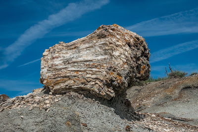
The first half mile of the hike takes us to a fork in the trail. Head left to the North Petrified Forest or right to the south. Distance wise, it looked to be about three quarters of a mile to either one. Rather than flipping a coin, we picked the north area because there was an earthcache placed there. It didn’t take long before we were in the heart of the petrified forest. There are probably hundreds of larger specimens there. They did seem to be more brittle than other petrified trees we have seen based on the large number of shards scattered around every one of them. 
Desolate Start to Hike


 It was neat to wander around them and check them out. There were other interesting rock formations in the area as well. Based on the number of bison chips scattered about, the herd we saw yesterday about two miles away might sometimes explore this area as well. Many of the petrified stumps are resting precariously on mounds of dirt that are slowly disintegrating. I suppose every now and then the pillar of dirt can no longer support the stone stump and it falls to the ground and breaks apart even more. Some of the stumps are over six feet tall and wide. After exploring for probably an hour or so, we turned around and headed back at the trail split we momentarily thought about checking out the South Petrified Forest area, but decided we have had enough. I suspect the round trip walk was between 3 and 4 miles. We got back to the car and had lunch before driving back.
Strange Capped Rocks


Wide View of Petrified Forest

Prickly Pear and Fleabane Daisies Sharing Dirt

Chris Poses for Scale

Won't Stay Upright Much Longer

More Capped Stones

Panoramic View on Way Back to Parking
Since the on-ramp to I-94 only heads eastbound, we decided to go into Medora to check out the town. The town is known for its outdoor theater during the summer months and we had checked into getting tickets for a play earlier in our stay. We quickly discovered that tickets were not cheap and given that sitting outside to watch a musical wasn’t really something we would enjoy even if it was only a few bucks, we had opted to just skip that part of the entertainment. I have heard of others who make it a big part of their stay in the area so if that’s what you like, I’d say go for it. Medora is a cute little town with lots of shops, a gas station and multiple restaurants and ice cream shops. After exploring the town on what was a hot afternoon, we concluded our day with an ice cream cone and talked with one of the locals about our full time travels.
Smokestack at Old Slaughterhouse in Medora
Pretty Sunset at Buffalo Gap
We had a nice stop at TRNP. Buffalo Gap Campground was a pleasant place, reasonably close to the park and very inexpensive. Our next destination is the east side of Glacier National Park. It’s about a 410 mile drive from where we are and there really wasn’t much we wanted to see or do along the way. Not to badmouth eastern Montana, but there isn’t a lot going on there. We had decided to have two driving days to get from Medora ND to Babb, MT. Our first stop would be the Elks Lodge in Lewistown. It was just about 300 miles which is well over our normal limit, but we were taking back roads (mainly state route 200) and other than a 30 mile stretch that was quite bumpy, the drive was reasonable. We pulled into the Elks Lodge about a half hour before a severe thunderstorm was to come thru. This lodge has a golf course associated with it and there was also some evening dinner that had drawn a crowd. Normally we check in with the bartender at an Elks Lodge but at this one we were greeted by the dining room hostess. We told her we were traveling Elks and were looking to stay for the night. She went to talk with somebody and came back a minute later and told us to park by the other trailer at the far side of the lot. She didn’t want to get any info or see my newly renewed Elks card. We hurried up and setup just before the winds picked up and the rain started. After it passed by, we walked around a bit but were tired from the drive and called it a night.
Ominous Clouds over Lewistown Elks Lodge
The next day we drove into Great Falls Montana. We planned to stay at a Walmart because we really needed to replenish the fridge and pantry with some food. This was especially needed because we were headed to a very remote area and it wasn’t clear what the grocery situation would be. The Walmart was just across the street from some large refinery. Definitely not our most scenic location in our 3+ years but it would work. The drive here was just over 110 miles so we made it in early enough that Chris could do her shopping while I ran out to get a haircut. It wasn’t the most peaceful spot to sleep but it worked and put us in easy striking distance of our real goal: Glacier National Park.