Map of this blog's locations click this link to open the map
We’re about halfway through our 13 night stay at James Robb State Park in Fruita. The front that brought some rain to the area has headed out and I managed to get the brakes on the old Jeep replaced. While at the dealership in Grand Junction, I spoke with one sales guy a few times about our wanting to get a new vehicle for towing behind the motorhome. He told me similar stories to what we heard in Durango regarding ordering new Jeeps. The build and delivery time is quite unpredictable. He knows of some vehicles headed to them that have been sitting at a rail yard for quite some time but they don't seem to have any means to get them moving to the dealership. They did have one Grand Cherokee Overland on the lot but it was the “L” version - meaning 3 rows of seating. It’s definitely not what we want but at least we were able to check out the general look of one and are definitely liking it.
So we are still torn between the Trailhawk and Overland models. Since we are likely limited to what a dealer has on the lot, I guess we will keep looking. We know we will be going into Utah when we leave Colorado and then heading south to St George and on to Boulder City Nevada. When we search Jeep dealer inventory on the main Jeep website, we aren’t finding much in that direction. There may be some availability in the greater Phoenix area and we can wait until later this fall or early winter?
With pleasant weather back in the forecast, we head out for some more hikes in Colorado National Monument. There are several trails that start just beyond the east entrance to the park so we head out early on a Friday morning. The main trailhead parking lot was already full so apparently we didn’t head out early enough. Fortunately there is also the Devils Kitchen picnic area just across the way and it has short connector trails to the main trails in this area. Our first hike was the Serpents Trail. It’s a 3.4 mile out and back hike with just under 800 feet of elevation gain. This trail is actually the original road into CNM. Construction started in 1912 and wasn’t completed until 1921. Fun fact, cars of that era lacked fuel pumps so they needed to be backed up the steep road to get gas to the engine!
 |
| Spur Trail from Devils Kitchen Picnic Area |
 |
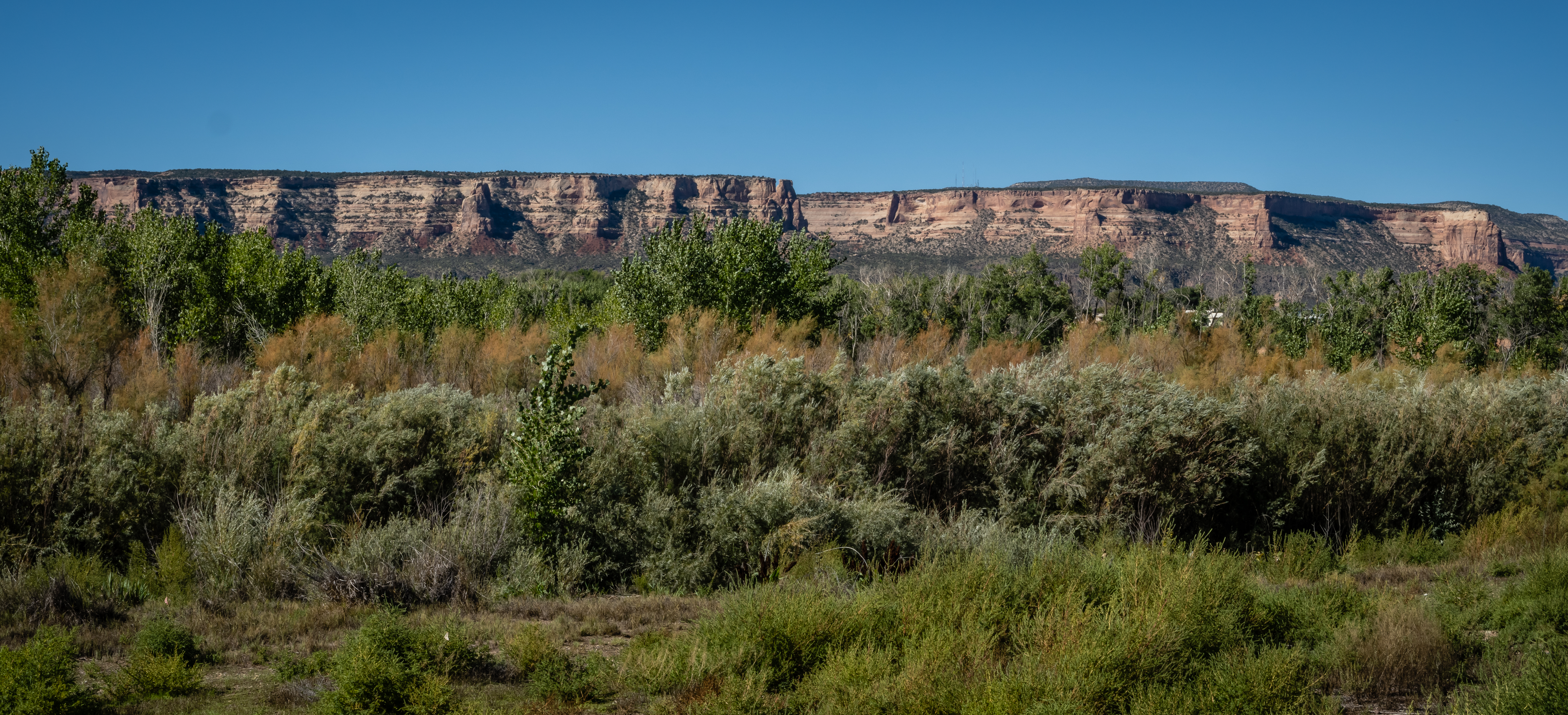
| View of Grand Valley |
 |
| Heading Up Serpents Trail |
Being the old road, it’s wider than most trails but that is good because there are a fair number of people out for the walk. Many of them seem to be locals that use this route for their morning walk. As we gain elevation, the views of the surrounding area get even better. To the south is the newer Rim Rock Drive which winds up from the valley floor to the top of the monument. |
| Long Way to the Top |
 |
| Rim Rock Drive Below |
 |
| Approaching Upper Serpents Trailhead |
The trail ends at the main park road near one of the tunnels. In fact the trail goes over the tunnel. There is also an upper trailhead parking area but it’s only large enough for two cars. I needed to get a picture of the tunnel so I walked down the hairpin curve and got a view of the 500 foot long opening. Even though I really wanted a shot from the opposite side, I realized it wasn’t wide enough to safely walk through. |
| Rim Rock Drive Tunnel |
 |
| View from Upper Trailhead |
The walk down was much easier. We had seen one of the rock formations from the bottom of the trail. It looked so small but we had now gotten fairly close and were above the top of it. Another rock sitting atop a pillar was balanced in a manner that didn’t look plausible.  |
| Heading Back Down |
 |
| Unique Rock Formation |
 |
| Impossibly Balanced Rock |
We made it back to the car and took advantage of the very nice picnic shelter at Devils Kitchen. There are 4 other trails that start out of this area. From the reviews of them, the Devils Kitchen Trail seemed to be the most popular after Serpents so after lunch we head across the road and start on this trail. It’s about a 2 mile out and back hike with 400 feet of elevation gain. |
| Heading to Devils Kitchen |
 |
| Scalloped Rock Cave |
The first quarter mile of trail acts as the starting point for several of the other trails but there are signs at each of the trail intersections to make sure we stay on the intended path. It’s a pretty hike with views of where we were earlier in the morning on Serpents Trail. Devils Kitchen Trail heads up a small valley with a now dry creek bed below us. We did run into a problem with locating the actual spot the trail is named for. We saw some large rock formations up on the side of the hill that might be what we want, but our Garmin handheld had a point of interest pin further up the canyon. A trail of sorts went in both directions, so we head toward the further point first to see what we find.
 |
| Apparently Devils Kitchen |
The trail we followed was right along the side of the canyon. Sections of it were rather exposed and had a long, steep drop off if your foot slips. Chris opted to find a spot to stop while I pushed on. I eventually ran out of trail and only found what likely is a pretty waterfall in the springtime but not much to see at this time of year. I decide that Devils Kitchen must have been the outcropping we saw earlier and head back to find Chris and go that direction instead. |
| Looking Back Down Canyon |
 |
| My Turnaround Point |
 |
| Heading Back in Search of the Devil |
We ran into a few more couples that had also missed the intended route. I informed them there wasn’t much of interest in the direction they were heading. We managed to make it to Devils Kitchen and started to explore. It turned out the rock pillars we saw form a bit of an alcove right along a ridge. There are a few windows in the rocks that you can look thru and the whole area provides a commanding view of this side of CNM. When we went to head back to the car, the trail was a bit more obvious and we made it back without issue. It was a nice hike even with the unintended diversion.
 |
| Carved Steps |
 |
| Approaching Devils Kitchen |
 |
| View from Kitchen |
 |
| Inside the Kitchen |
We knew there were dozens of miles of paved bike trails along the Colorado River but we wouldn’t be able to bike the full complete route in a single ride. After investigating the various sections of the trail, we realized that one of the better parts could be accessed just a few blocks from our campground. We pick up the Colorado River Trail in Fruita and head east towards Grand Junction. We would let the wind conditions and our legs dictate how far we go but we hoped to make it to one of the other sections of James Robb State Park - the Connected Lakes section just west of Grand Junction.
We had a bit of a headwind and we were going slightly uphill, but we prefer to have that at the beginning of a ride so that the return trip may be a bit easier. Much of the first 5 miles is more or less parallel with I-70 or an access road next to the expressway so it isn’t the most peaceful bike ride. But it is still a pretty one with views of CNM just to the south. There are lots of small open irrigation channels running right next to the trail. It seems that landowners can simply tap into it in order to irrigate their fields or lawn. I guess that’s why this valley is so green looking. Being right next to the Colorado River has its advantages. |
| Golf Course with CNM in Background |
 |
| Horses in Their Pasture |
 |
| Another CNM View |
 |
| Along the Colorado River |
Once The bike path and expressway diverge, the ride feels a bit more remote and peaceful. We have a few geocaches to look for along the route. As we get closer to Grand Junction, we go past some sort of mini amusement park. It has go cart tracks, large slides, a pool and miniature golf. The people riding the go carts seemed to be enjoying themselves. |
| Geese Sculpture |
 |
| Go Karts |
 |
| Bananas Fun Park |
Where the bike path intersects Broadway, we get onto the path that heads southwest along the road and bridge over the Colorado River. About 1/3 mile along this bike path we hang a right onto the Audubon Trail. This will lead us into the Connected Lakes section in just under 2 miles. We have our Colorado State Park pass along with us, but it seems to be an unmanned park with a kiosk for entry. We work our way around some of the lakes on the trail and find a picnic shelter with a beautiful view to enjoy our lunch. |
| Heading to Connected Lakes |
 |
| Our Lunch View |
From the trail maps we had, it looked like we could continue thru the park to the western edge and take a trail into an adjoining neighborhood and find a way back up to the bike path going back over the river on Redlands Parkway. It worked out well other than a rather steep hill out of the park. It was an easier ride back to camp with the slight tailwind and downhill. One of the bridge supports for a road over the bike path had a painting on it that was more than just your typical graffiti. Much more impressive than “Kilroy was here”. We ended up getting in a 27 mile ride. It was a bit longer than we planned so we treated ourselves to ice cream at the Dairy Queen right across from the campground entrance. |
| Another Lake View at Connected Lakes |
 |
| Crossing Over Colorado River |
 |
| Beautiful "Graffiti" |
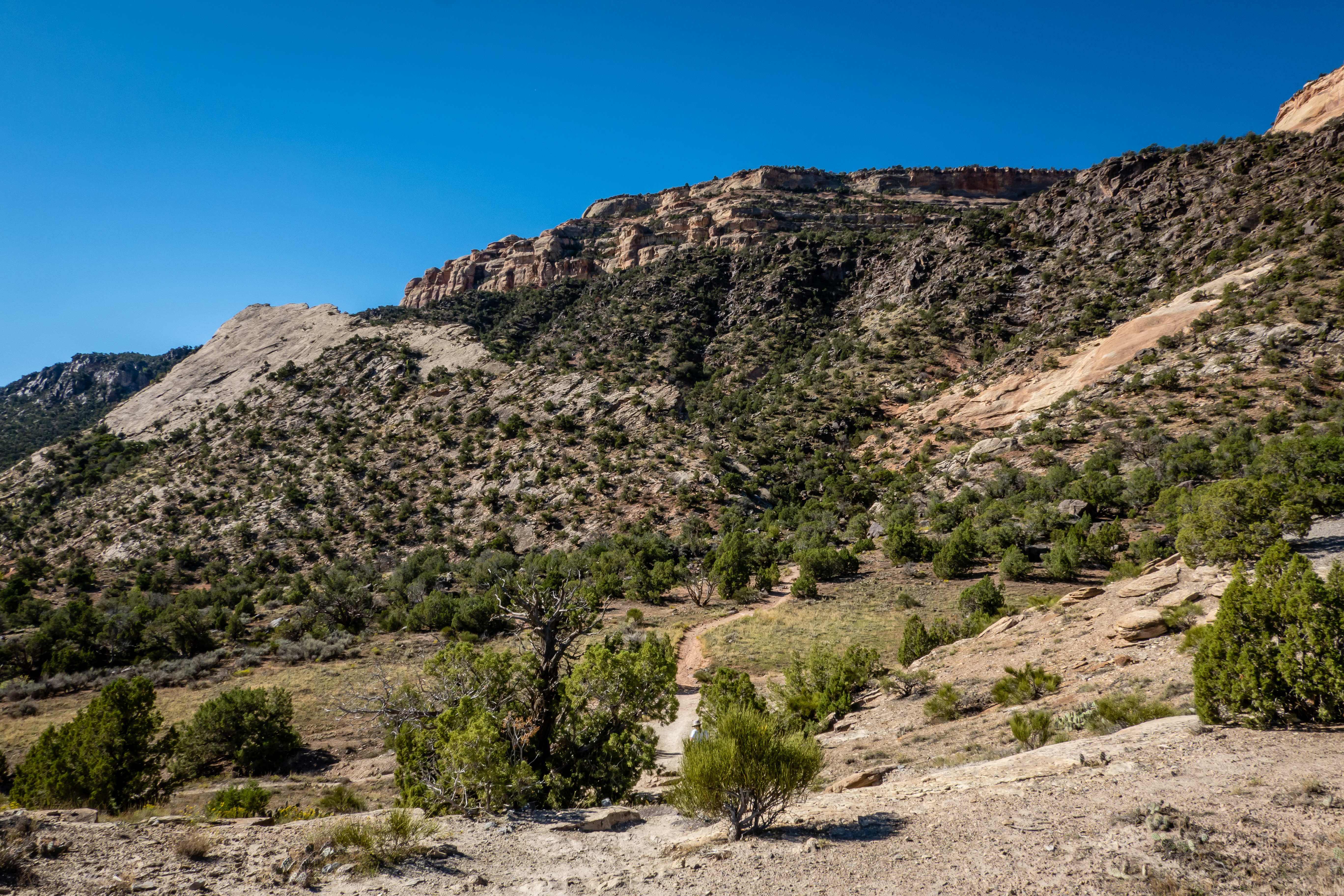
After a day off, we went out for one last hike in CNM. The Liberty Cap, Ute Canyon and Corkscrew Trail is a 3 mile loop with more then 900 feet of elevation gain. Similar to a hike we did a week earlier, this one starts outside the eastern edge of the park and comes into the park for the majority of the hike. |
| At Liberty Cap Trailhead |
During the first part of the hike, even through the trail was marked fine, it was a bit confusing since we only gained 100 feet in the first 1/3 mile. We knew there was going to be some climbing involved but as we look at the cliff ahead of us, there was no discernible trail to be seen. But we just kept following the well worn path and as we got closer, we could see there was a bit of a valley between the main cliff and a rock fin that is no longer connected. This was the gap we were heading up to gain our altitude. It was a narrow, rocky and steep trail. I found my long legs beneficial at points although Chris managed to make the climb too. |
| Approaching Gap Between Fin on Left and Cliff on Right |
 |
| Looking Back Down Partway Up |
 |
| Rocky Terrain |
This is the same trail that splits off and continues even steeper up to the top of Liberty Cap. The Ute Canyon Trail continues to the south along a relatively flat section of the loop about 400 feet below the top of Liberty Cap. We definitely get some excellent views both looking down into the valley or looking up into the higher parts of CNM.
After a short break for a snack, we split off to the Corkscrew Trail portion of the loop. This is definitely one of those trails where from the top we are looking down and thinking “our trail goes down that?”. I was a bit nervous Chris’ fear of heights would kick in and we would be forced to backtrack the way we came. |
| Near Top of Corkscrew Trail Looking Down |
 |
| Into the Unknown |
 |
| Lizard |
There were many places where the trail is rather exposed with steep drop offs. A few spots where we can see our trail below but not being able to see the route down to it. At least in these places we had the benefit of know we would only fall 20 feet instead of 200 feet! We took our time and slowly made our way down safely. At the occasional rest stops, we would look back up and since there is no indication of the trail we just came down, we were unsure how we had made it down. I guess Corkscrew is a good name for this trail. |
| Continue on Skinny Trail Down |
 |
| Don't Look Down Chris! |
 |
| We Came Down That? |
 |
| More to Go |
The steep portion of this trail was only 3/4 mile long but seemed to be at least double that. The last mile of the trail was mostly a gradual downhill. As we approached the edge of the park with the adjoining BLM land, we went off trail a bit to search for a few geocaches hidden off some minor trails. We were a bit surprised to run into another couple well off the main trail. We stopped to make sure they weren’t lost since they didn’t seem to be geocachers. Turns out they have a home very close by and we’re out for a walk. They were worried we were lost! We enjoyed the hike even with the scary corkscrew section. |
| Another Look Back Stop |
 |
| Getting Close |
We had originally planned to stop at the nearby Kindred Reserve for more hiking but the morning’s hike took a lot out of us so we only went there to eat our sandwiches and get a couple more caches inside the reserve.
For our next to last day in Fruita, we went on a bit of a road trip. We needed a cache from the county just to the north of camp. The problem was there aren’t many roads (or caches) up there. If instead of heading due north, we headed northeast on I-70 for about 45 miles, we would cross into Garfield county and find a cache not far from the interstate. Once that task was complete, we turned around and headed into the town of Palisade. We didn’t know much about the town except for the fact that we have been seeing stands all over Colorado selling their peaches.
We used some of the highly favorited geocaches as a bit of a tour guide in the area. The first one was a bit tricky. We arrived at ground zero and all that was there was a telephone pole with conduit coming out of the ground and running into a 480 volt electrical panel. We looked around for a fake rock or some other container but didn’t spot anything unusual. The panel was unlocked so I could open it up and inspect it. There were large gauge wires running to three fuses so at first glance there was a chance this was a real panel. As a former electrical engineer, I have a healthy respect for electricity so I am a bit overcautious. I would normally test the circuit with a meter, but don’t carry one with me. So I throw the switch from on to off and look around to see if anybody is upset that I cut their power. There was no reaction from any of the workers 200 feet away. I’m starting to feel a bit more confident this is the cache and no electricity it feeding the panel. I pulled each fuse and discovered one of them opens up and has a log in it. It’s a very creative hide although I get concerned that someone that finds this one may try messing with a live panel at some future cache site and get a good shock. |
| Geocache? |
 |
| Yep! |
A few more caches took us around town before we head to Red Fox Cellars. They make both wine and hard cider so we got a flight of each and sat out on the patio giving them a try. Most of their wines are on the dry side which is to our liking. The ciders were okay but they seemed to be big into flavored ciders. Roasted chile dry cider was interesting, lemon-ginger cider was not a good combination for us. Palisade is a large agricultural area which seems a bit odd given how dry the climate is. But I guess the soil is good and they have lots of water from the Colorado River to irrigate the crops. We stop at one produce stand and pick up some local items that are in season. |
| Rusty's (the dog) Dream |
 |
| Artwork Downtown |
 |
| Red Fox Cellars |
 |
| Orchard in the Desert |
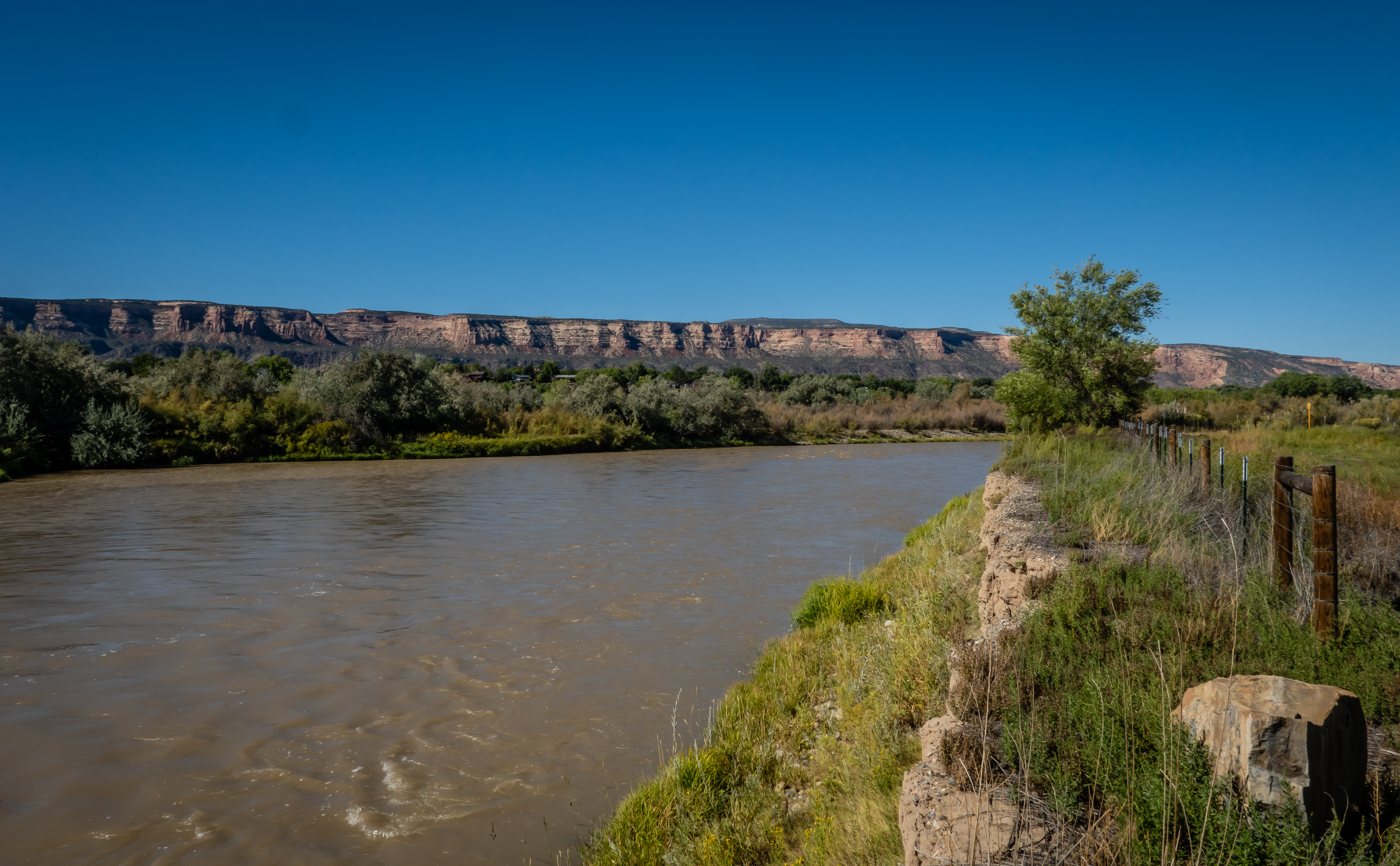
As we came back to camp, we stopped at a bike path along the Colorado River near the confluence with the Gunnison River. We were hoping to see where the two come together. We had made a similar stop where the Ohio and Mississippi Rivers combine and thought it would be neat to see this one. There was a guy walking his dog and we asked him about where we might be able to see this but he said there really isn't a place on land where we could experience it. Oh well. |
| Colorado River Just Beyond Confluence with Gunnison |
 |
| Skate/Bike Park Along Trail |
On our last night in Fruita was our 142nd night in Colorado. We pulled in to the Loveland area on May 10 and will be pulling out from here on September 29. We saw a lot of the state but could probably do this again next summer and see all sorts of new things. Our next stop will be at a very remote state park in Utah - Goblin Valley. |
| Entrance to State Park at Sunset |
 |
| War Memorial Near Fruita Visitor Center |