Wednesday, January 2, 2019

Cedar Key Wrap-up

Map of this blog's locations click this link to open the map

Another Cedar Key Sunset
We have enjoyed the first couple weeks at Sunset Isle RV Park in Cedar Key. Even though there are a lot of people here for the season, the park isn’t completely full with seasonal guests so there seems to be a fair number of rigs coming and going. The town is kind of out of the way and isn’t on the way to anywhere else, so all those showing up are here to see the town. We continue to wander around town either on foot or by bike and you know it’s a small town when we start to recognize people from the RV park in town. One of the places in town is the Cedar Key Museum State Park. As far as state parks go, this is likely one of the smallest ones we have visited. The one building is a museum of everything related to the history of Cedar Key. 
Cedar Key Museum State Park
Turtle Shell

Brain Coral

Large Shell

A separate house on the property is that of St. Clair Whitman. In the early 1900’s, he was involved with several businesses in town and also had an extensive collection of seashells and Native American artifacts. His home was relocated to the park’s property and restored to be part of the museum. He definitely did have a large collection of shells. Some of them don’t look like real shells. Mother Nature sure has some creativity.
Various Shells

Intricate Shell Design

Butterflies

More Shells
We headed back up to Manatee Springs SP to do some hiking and geocaching. We were there only two days after the 6+ inches of rain that hit the area. At the spring, it was very apparent just how much the Suwannee River had risen. Some of the places we had stood to watch the manatees was now a foot under water and was expecting to continue to rise as the flood waters from up north make its way downstream. We were pleasantly surprised that the hiking trails were in great shape. There were no wet spots and not even much indication how much rain had fallen days earlier. We managed to get in just over 6 miles of hiking and found the majority of the caches in the park. It turned out to be a nice place for a hike.
Flooded Manatee Viewing Area

More Flooding
Replica of Indian Hut

Elaborate Thatched Roof
The next day we drove about 45 minutes south of Cedar Key to the town of Inglis. My goal was to cross over into Citrus county in order to find a cache in another county. It may have been a rather lame reason but it did bring us to a nice trail along the Florida State Barge Canal. The Withlacoochee Bay Trail is a nicely paved path that is plenty wide for walking or biking. We found some side trails that took us back to a few additional geocaches and had a nice time.
Along Withlacoochee Bay Trail

Overlooking Florida State Barge Canal
On our way back, we stopped at the nearby Withlacoochee Gulf Preserve in Yankeetown. The dirt road through the preserve has a few stops along the way to do short hikes. The boardwalk brought us to a pretty pond setting where there were several wading birds looking for a meal. The nearby trails were pretty much flooded from the recent rain so not much hiking was accomplished. They do have a 30 foot tall observation tower but there wasn’t a whole lot to observe from a nature standpoint but it did provide a view of the smoke from the nearby coal and nuclear power plant. 
On the Prowl

Taking Off

Power Plant


One day we headed to Fanning Springs State Park leaving early enough to do both a hike as well as a bike ride. Being the middle of the week, the park was just about empty. The bulk of the viewing platform for the fresh water spring was under water. With so much river water mixing into the spring area, the water was quite murky. If any manatees were there, we didn’t see them. After a couple mile hike and a few geocaches, we had lunch and changed into cycling clothes. The Nature Coast State Trail is right next to the state park so we just left the car there instead of driving 1/2 mile to the parking area for the trail. At this location, the trail runs roughly north and south. We head north a couple miles until it splits into a trail heading east and west. We go a couple miles west to see the old bridge that crosses the Suwannee River. 
Flooded Walkway at Fanning Springs State Park

Viewing Area Submerged
Old Bridge Over Suwannee River
We then turn back and head east along the nicely paved trail. We found it interesting that the bike path was adjacent to several roads along the way and the roads were dirt with a paved bike path. There were numerous oak trees along the trail, and the acorns from this type of oak tree are much smaller than we are accustomed to. Under each oak tree along the trail, the path was covered with hundreds or thousands of acorns. As we road over them, they popped loudly almost like firecrackers. I cringe at how many future oak trees lives were thwarted by our bike ride! We went as far as the town of Trenton (Florida, not New Jersey) where we stopped for a well deserved ice cream break. By the time we turned around and made it back to the car, we had a 24 mile ride in. 

Welcome to Trenton
The following day was another rainy one but only a couple inches. By mid-afternoon, one of the workers from the RV Park stopped to chat with us. There was a flood warning for Cedar Key. There were gale force winds coming in from the west and we were near a full moon. At high tide later that evening (~11:30 PM), the water was expected to flood out portions of the campgrounds. He was asking the rigs parked right next to the shore to move their rigs but he “thought” our spot would “probably” be okay. He mentioned the bridge off our island back to the mainland was going to close at 10 PM to make sure we didn’t get stuck in case we had planned on heading out for the evening. He wasn’t too reassuring, so we did a little bit of prep work just in case we need to move. Two of the motorhomes on the water didn’t plan on moving which kind of surprised us. I talked with one of the guys and his comment was if his rig floods, he would just file an insurance claim!

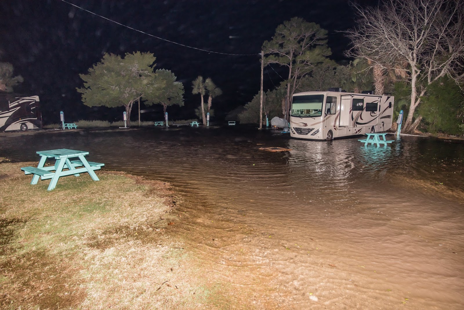
I found myself heading out every hour or so after sunset, to get a feel for how fast the water was coming up. Fortunately the wave action was minimal, but the water was definitely coming up quickly. The two motorhomes that didn’t move, were completely surrounded by water well before high tide. Our rig was on a site that was probably only 12 inches or so higher than the other ones and it was almost an island when high tide hit. I could see the water touching the bottom of the fiberglass shell of the one motorhome and their wooden pallet they used as a step out of the rig was floating 20 feet away in the middle of the road. Fortunately the water never even got to our tires. Ten minutes after high tide, I could see that the water had already started to recede and we could go to bed knowing we weren’t going to float away.

Water Coming In

Our Neighbor Surrounded

Flooding at Shoreline

Our Rig on Right - High and Dry!?!

Nearly Surrounded

The Morning After
A couple days after the flood, we head back to the Florida State Barge Canal but bringing our bicycles this time. We road to the far west and east ends of the trail and found it to be a rather nice bike ride and much easier to get in some distance as well as a few of the geocaches we hadn’t gotten to on our previous trip. It was only a 13 mile round trip but a pretty nice and flat ride.
Power Plant


The next day we headed to the town of Chiefland with the goal of riding more of the Nature Coast State Trail. We found the trail but did have trouble spotting a nearby parking area. Since it was Sunday, we just parked in the big lot at the town hall and biked the half mile over to the trail and headed north. This section of the trail is quite shaded and would have been a better choice to do on a warmer day. When we got into Fanning Springs, Chris looked over the map and decided to see if we could turn the next portion of the ride into a loop. We continued north to the split and headed west over the Suwannee River and then made our way into the Old Town. They had some decent bike trails along the road in town so the ride turned out to be even more pleasant than we had expected. It turned into a 28 mile ride until we made our way back to Chiefland. 
Way Down Upon the Suwannee River


With all the recent bike rides, we needed to change it up a bit. There is not a ton of hiking in the immediate area, but we did find a trail system in the Goethe State Forest. It’s about a 45 mile drive but sounded like a nice place. When we pulled into the area, we were unsure it was even open. The main road was flooded with a couple feet of water. Another road got us around the flooding and to a dry parking spot. There was only one other vehicle with a horse trailer. 

Flooding at Goethe State Forest
The Black Prong Trails are multi-use so we know there is at least one other person using the trails.  We look over the trail. As and decide to try the blue trail which would be about a 6 mile loop. The trail starts out as a dirt road for the first 1/4 mile before the blue trail heads north. We only made it up the blue trail  a tenth of a mile before we were greeted with a completely submerged trail. We were unable to see a way around the flooded section so we turned around and headed further out the road. We even ran into some flooded sections on the road. None of them were so bad that we couldn’t get past them but it was then we decided it might be advisable to just follow the road rather then venture onto any of the trails since, the whole area appeared to be low lying and likely to include impassable sections. We headed out the road just over 2.5 miles and by then we were on slightly higher ground so the area seemed to be much drier. But we still realized heading down any of the side trails we came across might not get us back to the parking area since the east end of the park seemed to be the wet side. It looks like it would be a good place to try during a drought!
Dry Section of Trail

Flooded Trail

Heron in Water Along Trail
The days around Christmas brought a huge influx of campers to the park. By my count there were fewer than 5 open spots in the campground. The good news was the volume and variety of foods at the park’s Xmas potluck was tremendous. There were a couple downsides to this though. It was impossible to eat even a small amount of all the food that was there and while proving that statement, we ate too much!
Long Line for Food

Load Up Plate
Eating with Friends
The following day, we headed back to the Nature Drive at Lower Suwannee Refuge. The plan was to actually get out of the car and do a hike. Closer to the southern entrance is the Barnett Creek Road Loop Trail. This is one of the better hiking trails according to the park’s literature. We start the hike and much like the other day, we hit a flooded section of the trail and are forced to turn back. Since we still wanted to hike, we just follow trails that are generally dry and get in a 5 mile hike. Besides several herons and an armadillo, we caught glimpse of a wild pig. It went splashing into the brush before I could get a picture of it. The gator we saw wasn’t having a very good day.
Why Did the Gator Cross the Road?

Fixer-Up'er

Pretty Butterfly


Armadillo

Turtle
I headed to downtown Cedar Key a bit before sunset to get some bird photos. Even though the telephoto lens I got back in May is fairly large and heavy, it does help to get some really sharp pictures.
Balance on One Foot


For our last visit to Lower Suwannee Refuge, we brought along the mountain bikes. We knew that the Nature Drive has a pretty good surface and there is minimal vehicular traffic. We figured riding bicycles would be a good way to see things at a slower pace. We parked by the trailhead lot near the refuge office. There wasn’t a clear path through the park to get the Nature Drive so we just biked down the road next to the refuge for the 1/2 mile to the northern entrance. We found the ride pleasant. There were only a few spots that were a little rough and any cars we came upon gave us plenty of room. We headed down many of the side roads we had passed by in the car. The boat launch was simply a road that ended in the waters of the Suwannee River. Cabin Road, near the south end of the ride, was much bumpier and not as fun to ride. After getting to the end of the road and never seeing a cabin, it was probably a side trip that should have been skipped. After turning back, we decided to go back the way we came rather than biking on the shorter and faster County Road 347. The round trip came in at 25 miles. 
Pond at Lower Suwannee

Colorful Maple


We finished up the year with a big New Years party at the campground. They had hired duo to come in and play guitars and sing. All the campers brought some hors d’oeuvers and we sat around and enjoyed the music. It helped that the weather was nice and the music being played were tunes we knew and liked. We enjoyed our stay in Cedar Key and while we found hikes and bike rides in the area, it didn’t offer the diversity we have come to need. It definitely is a good place if you’re looking for a laid back, low key destination. 

Art at Cedar Key Community Garden


Foggy Day

Coming in for Landing