Monday, June 29, 2020

Our Fourth Year of Fulltiming in Review

June 28, 2020 marked the end of our fourth year of living in our motorhome full time. What a wonderful turned crazy year it was. We started out up in Montana as we continued our tour of some of this country's wonderful national parks. A month at Glacier NP, 3 weeks at Yellowstone NP and 10 nights in Grand Teton NP. That might sound like an eternity to many travelers but in hindsight we should have budgeted more time. As full timers, we do have a good amount of flexibility in our travel schedule but this year required a fair amount of advanced planning to get camping spots reserved. So our budgeting of time at each stop needed to be done many months ahead of time. The good news is that we now understand the beauty of these parks and can put a return trip in the works for some future year spending even more time there.

We continued south to our next major stop - Moab Utah. This is home to Arches NP, Canyonlands NP and the equally impressive Dead Horse Point State Park. Our 19 nights in this area seemed to fly by but we had another bucket item stop this year a bit further south - the Albuquerque Balloon Fiesta in early October. In fact as we were putting together our travel plans for 2020, the Fiesta was the first thing we booked  and then we determined a route and stops that would allow us to end up in Albuquerque at the right time.

After the Fiesta, we dropped back into a free form travel mode and for the next 7 to 8 weeks we wandered around northern Arizona and southern Nevada trying to stretch out the autumn months for as long as we could before dropping back into a familiar spot in Desert Hot Springs California where we spent the holidays.

Mid-January brought us back into Arizona where we bopped around to some familiar areas and several we hadn't visited before. For those two months or so, we had a wonderful time. Then Covid 19 hit. By mid-March as shutdowns and social distancing became the norm, we started to pay a great deal of attention to the status of campgrounds. We were hearing way to many stories of state parks closing and even some private campgrounds having restrictions placed on them and forcing campers out. At one point, one source figured that over half the campgrounds in the US were closed! This was the first time in our travels where we almost wished we still had a sticks and bricks house to go self isolate in peace. 

So as our 4th year comes to an end, I am writing this post holed up in the mountains of eastern Arizona instead of at a scenic spot in the Canadian Rockies getting ready to go to the Calgary Stampede. Everyone has been put through some tough times and I realize our "problems" pale in comparison to what many others have experienced. At some point in time, we will be able to resume our normal travel routine.

So let me get into some of the facts and stats from the past year. Below is a picture of the Google Map I use to keep track of our stops. Clicking the link below the map will open up the actual Google Map for our fourth year travels. Clicking on an of the pins for our stops will display a pop up window with a link to the blog post(s) for that stop.


The next two maps show each state shaded proportional to how many nights we stayed in it. The first one is for just our 4th year. Even with the extra day from Leap Year, we only managed 9 states! In the prior three years we camped in 22, 13 and 22 states.  The second map shows the culmination of the first 4 years full timing. I feel we are doing pretty good at 41 states. We have nothing against Nebraska, Kansas, Oklahoma, Mississippi, Delaware, New Jersey, Rhode Island, Hawaii or Alaska. In fact we have camped in many of them, just not during our full time years.


Our Fourth Year

Our First 4 Years

How did year 4 compare to previous years? Well many of the stats related to year 4 should probably receive an asterisk next to them since they are impacted by Covid 19. But be that as it may, we definitely dropped our number of camping stops for the fourth year in a row. This in turn got our nights per stop up to over 12 - not quite twice as high as our first year. I guess this shows it is possible to slow down the travel pace.


Both motorhome and Jeep mileage dropped significantly. Cost for diesel fell as well but gas price for the Jeep is up. I split the camping into a few categories: boondocking, federal/state/county/city parks, private parks and Elks Lodges. This past year definitely skewed towards private campgrounds although by staying longer we often got the monthly rate and saw a good benefit in the nightly price. Our boondocking costs might see a bit high. While I do include diesel to run the generator, that usually is only ~$4/day. This year we boondocked at the Albuquerque Balloon Fiesta and I've factored in the $45/day fee. The net result came in at just under $29/day.


Condensed Stats

As part of our year end review, we like to go back and pick out stops that were highlights for the year and mention a little bit about them. I'll put a favorite picture and a link to a blog post from that stop in case you have more interest in checking it out vicariously from our travels. In chronological order, here our our top picks for year #4:


  • Glacier National Park - Hands down, my favorite NP so far. The hiking here is excellent along with the sheer beauty of the place. Chris will only rate it at the #2 National Park with Acadia NP in Maine beating out Glacier for the top spot. Needing to hike with bear spray and keeping a watchful eye out for bears likely being Glacier's achilles heel. As avid hikers, we spent more time on the east side of the park. Casual National Park visitors will likely prefer to stay on the west side of the park. First Glacier NP Post


Mountain Goat Poses
  • Yellowstone National Park - This park is huge and has a wide diversity of things to see and do. There are the obvious thermal features like Old Faithful and the ever present bison causing traffic jams. The hiking is okay but not particularly spectacular. The biggest downside to Yellowstone is possibly its popularity. Expect crowds and limited parking at some of the popular stops. If you haven't been there, it is a "must do". First Yellowstone Post
Overlooking Grand Prismatic Spring

  • Grand Teton National Park - Another beautiful National Park. Much smaller than Yellowstone but also less crowded. Some excellent hiking and lots of animals. We stayed in Gros Ventre Campground within the park and had moose visit on three of the mornings we were there! Grand Teton Blog Post

Three Moose Checking out the Dutch Star

  • Moab UtahOkay maybe cheating a bit since Moab is often used as the home base to visit both Arches NP and Canyonlands NP. We stayed in two spots during our 19 nights to better cover both National Parks but I suspect most people visit both from one campground. Arches has some excellent hiking with some incredible scenery. Canyonlands NP has some beautiful sights and hikes. And even though the two parks are near one another, don't think you can visit one and extrapolate what the other is like. They are two very different National Parks. Another stop in between the two National Parks is Dead Horse Point State Park. We actually camped here so we could explore it thoroughly. It's more like a mini Canyonlands but still worth a visit. First Moab Blog Post
Landscape Arch at Arches NP


  • Albuquerque Balloon FiestaEveryone has heard of it and seen pictures or video from it. Most people will say it is on their "bucket list". Trust me - you should move heaven and earth to make it happen. Yes it is that amazing. You will find yourself looking forward to getting up at 5 AM in order to see Dawn Patrol. So what are the downsides? Getting up early. Crowds. Traffic. This event does require some advanced planning. Make every effort to camp on site so you don't need to sit in traffic trying to get to the launch field. If you want to get camping on site on your own, you'll need to book a site a year in advance and even have some luck to make that happen. We booked our site through Escapees although there are many groups that can be used as an intermediary. Balloon Fiesta Post
Glowing Cat Eyes at Sunset


  • Prescott Valley ArizonaWe really enjoyed this area during our stop. The original plan was to stay 10 nights but we enjoyed it so much we extended to 17 nights. What is so special? Again, we enjoy hiking and geocaching. This area has both of these in spades. Some of the most creative geocaches we have done have been placed in the area. And there are some pretty hikes as well as what is like the most "moving" hike we have done at the Granite Mountain Hotshot Memorial. First Prescott Valley Blog Post

Reflections


  • Cave Creek ArizonaA county park in a small town north of Phoenix along the Carefree Highway (think Gordon Lightfoot's song). Some great hiking out of the campground. Horseback riding if you're so inclined. We even found some nice mountain biking nearby. Wish we could have snagged more than 6 nights at the campground. Cave Creek Blog Post

Hiking Trail at Cave Creek


  • Bisbee ArizonaLess than 8 miles to the Mexican border, Bisbee is an old mining town. The historic district is a very cute town. We found lots of interesting things in the area. Whitewater Draw was an incredible area for Sandhill Cranes and other birds. We even got to tour an active Army base at Fort Huachuca. First Bisbee Blog Post

Entering Queen Mine in Bisbee

Thursday, June 25, 2020

Show Low Part 1

 Map of this blog's locations click this link to open the map

With our 2 month stay in Camp Verde ending, it was time to move on to higher elevations and hopefully cooler temperatures. We’ve been camping right next to State Route 260 and following it east gets you to Show Low in about 150 miles. While it likely would be a beautiful drive, it’s not listed as a truck route so we opt to do the slightly more mundane and longer (187 miles) route up I-17 to Flagstaff and east on I-40 to Holbrook before taking SR-77 south. This gave us another opportunity to use our TSD Logistics fuel card. Two months ago, Love’s truck stops were the ones with the biggest discounts and had saved over 91 cents per gallon. Now TA truck stops are the better deal. We filled up in Holbrook and saved nearly 86 cents per gallon for over a $55 net savings.

We were coming into Juniper Ridge RV Resort on Memorial Day, so their wasn’t anyone at the office to check us in, but we had been given the gate code to get to our site. I’ve mentioned before that this place doesn’t show up as a campground on any of the standard apps we use because it is an ownership park. We had found the resort from somebody listing a site for rent. It is located on the northern end of Show Low and while we would have preferred to be further south in the Pinetop-Lakeside area where much of the good outdoor recreation is, we couldn’t find as nice a place for an extended time.

Entrance to Juniper Ridge

Our site is owned by a woman looking to sell the lot but willing to do a monthly rental. I suspect she was quite pleased when we said we were looking to stay for 4 months. The going rate for site with concrete is $650/month plus electric. Gravel lots are a little cheaper. There are over 400 sites in the resort but most of them are either park models or fifth wheels that have permanent skirting along the bottom. I’d estimate that less than 10% of the sites are used with RVs that actually travel. Many of these sites do have improvements on them. Ours has a shed with washer, dryer and fridge we can use. Some have large metal carports to provide a shade and rain protection. Unfortunately ours didn’t have one of these.
Our Site for 4 Months

As we pulled in, a few of our neighbors came out to great us. One woman is friends with our landlord and was apparently given the assignment to check on us and report back. Later we overheard a loud phone conversation where we were called a nice young couple. Juniper Ridge is a 55+ park, but I suspect most people staying here are well north of that age! There is an 18 hole golf course in the resort, swimming pool, hot tub, exercise room, tennis, bocci, shuffleboard etc... We realized that many of the amenities are either closed or have certain restrictions. Such is life during a pandemic.

We got situated on our site with no real issues. While our site has a large concrete pad, the RV would take up most of it so we park in the gravel right next to the pad like the owner’s 5th wheel had been. We chat with a couple of our neighbors and get the key for our shed from one of them. Besides the washer, dryer and fridge, there a few of the owner’s items remaining, but there is plenty of room for our mountain bikes, grill and other odds and ends. It will prove to be quite convenient to have access to a dry spot rather than putting our stuff away in the rig when rain is expected.

The next morning we head down to the main office to sign paperwork and pick up a mailbox key as well as learn a bit about the resort. We find out the park does a good job with both a weekly newsletter and other emails when there are announcements important to the residents. Even though we have very good Verizon signal here, there is no over the air television signal to be found. So we opt to get a cable modem from the local cable company. The self-installation would have gone okay if the signal at the pedestal was working, but a call to the company had somebody stop by within the hour to get us set up. We have grown accustomed to the “unlimited” Verizon plan for data. The first 22 GB per month is at full speed. After that, the speed might be throttled although our experience has been that seldom happens. The plan from the cable company is 350 GB per month! We dust off our Amazon Fire Stick for streaming news and shows and rediscover the joys of truly unlimited data. We seem to average about 220 GB per month so well below the cap but 10 times our normal.

Since we are here for four months, we don’t feel obligated to check everything out right away. We go out for a bike ride hoping to find a loop around nearby White Mountain Lake. From the aerial view in Google Earth, it looks like we should be able to accomplish such a task. Unfortunately when we attempt to go clockwise around it, we are greeted with a no trespassing sign about half a mile from the exit of the resort. We instead go back and try some of the paved roads in the small community surrounding the lake. The roads don’t have much of a shoulder but traffic is rather sparse. On the north side of the lake, we come across a dirt road that seems to be heading back the way we want to go. After a mile or so of reasonable road conditions, we come upon a barb wire gate and another no trespassing sign. Our only option was to backtrack the way we came for a 13 mile ride. I later pulled up our tracks from the GPS and discovered there was only a quarter mile section between the two trespassing signs. So close to being a great cycling loop near our campsite.

We picked up some literature from the Apache-Sitgreaves National Forest ranger station to get a feeling for what types of hiking and mountain biking activities are in the area. From the looks of things, we won’t run out of options. Like I mentioned earlier, the vast majority of the trails are in the town of Pinetop-Lakeside to the southeast of us. Fortunately it’s only about 20 miles away, so it’s only about an hour of travel time. Plus most of the big stores are along the route, so we tend to be able to tie in shopping when needed.

Our first hike takes us to the Timber Mesa Trailhead. AllTrails lists it as a moderate 7.6 mile loop with about 600 feet of elevation although it is at an elevation of just under 7000 feet. So we shall see how our lungs handle the thinner air. At the trailhead parking, there is a Jeep road that appears to stay low on the edge of the mesa. The hiking trail however (if you take the loop in the clockwise direction), starts out with a decent climb to get to the top of the mesa. It doesn’t take too long to get to a point with wonderful views of the surrounding area. Mountain biking is also permitted on this trail but in our estimation much of the loop would require us to walk our bikes. Before we got to the top of the mesa, a couple of bikers came thru and seemed to be doing reasonably well - way better than we could have.

Heading Up the Trail


It was a pretty hike. The eastern portion of the hike has a couple miles of fairly flat terrain where we wished we did have our bikes. A fair number of wildflowers were in bloom which attracted butterflies and then there are the ever present lizards. The name of the hike (Timber Mesa) seemed appropriate since there was a large section of the woods where the pines had been cut and piled up waiting to be skidded out to a fire road. With a few detours, our hike came in just over 8 miles and was quite enjoyable.

Bright Flowers


Butterfly

Lizard

Piles of Lumber

One of the perks of Juniper Ridge that I was looking forward to was the woodworking shop. Early in our stay, I went to the meeting to find out what it took to get access to the shop. There wasn’t much involved - signing a waiver about cutting off fingers and a $20 fee. While we were in Yuma, I had tried to make a simple bike support that would attach to the ladder on the rear of the rig to permit the bikes to lean against the rig but not damage it. Not all campgrounds have a picnic table, or even trees to lean the bikes against. I had discovered how difficult it can be to cut a 2 by 4 square with a hack saw! So my first project to investigate the shop was to redo the bike support. The shop isn’t huge - maybe 600 square feet -but it is reasonably well equipped. It appears that the most popular use for the shop is to turn bowls or pens. They have 3 lathes in one section of the shop. I felt a bit out of place making such a simple item from common 2 by 4’s.


Bike Support Detail and Clamped to Rear Ladder


A few days later, we drive back towards Pinetop-Lakeside to try out the Ice Cave Trail. The name sounded interesting. It’s an out and back trail that connects to the Blue Ridge Mountain Loop. The trail starts out going past some horse farms. From the looks of the trail, taking a horseback ride is a popular activity. The trail winds thru a meadow before going along the southern end of Scott Reservoir. There were abundant wildflowers along the way and most of the trail is shaded.

Ice Cave Trailhead

Heading into Meadow

Southern End of Scott Reservoir

Iris


Sego Lily
We did eventually run into some groups on horseback as we searched for the cave. I guess we should have asked one of the groups about the cave’s location because we made it all the way to the Blue Ridge and never spotted a cave. On the way, back we saw a well used but unmarked trail and assumed this must be the way to the cave. Sure enough the cave isn’t too far off the main trail. The cave opening is surrounded by a chain link fence with barbed wire around the top. Water erosion had made an opening underneath the fence that could easily be crawled under but we respected the intent of the fence and stayed out. Even though we were 25 feet from the opening, we could feel the cold air rushing out of the cave. It was a pleasant 7.5 mile hike although the cave wasn’t all that impressive.
Ice Cave Entrance

Young Ducks?

I was still looking for a decent mountain bike ride near camp. On the west side of the park is a dirt road called Stallion Lane. I decided to go out and explore to determine if it was worth biking there. From the tracks in the dirt, I can tell it gets driven on but it definitely isn’t a maintained road. There are numerous spots where large rocks stick out of the ground making it a challenge to bike thru. It only goes back 2.25 miles before hitting yet another gate with a no trespassing sign. I end up repeating sections of the dirt road multiple times to get up to a 10 mile ride by the time I get back to camp. 

After several days of this, I run into a guy driving his pickup truck a mile or so up the road. I think he was surprised to see some idiot out here on a mountain bike. We talked for 10 minutes and turned out he owns the place beyond the gate. It is definitely an out of the way location and probably takes him 30 minutes to negotiate the rough road. He gave me permission to continue straight past the gate as long as I didn’t head right towards his house. His comment was his dog’s have never seen another person other than him and his wife. Over the next several weeks, I continue to explore some of the area and discover that two of the “roads” lead back to Sitgreaves National Forest land.

There are a few other abandoned structures back on some of the paths but I typically don’t see any other people save for the occasional walker or jogger from the park. Some of the less traveled paths tend to have some extreme cracks in the ground. They make for a very bumpy ride and at times I fear my front tire will drop into one and flip me over the handlebars. I even explored past the barbed wire gate at what I suspect is the edge of the National Forest. This is open range cattle area but I only came across them once so far. They have some nasty looking horns so I hope to not have a run in with them. I have also seen a pronghorn once and know there are elk in the area but have yet to see any during my rides. I probably get out a couple times a week depending on the weather. While it isn’t a nice ride, it does provide a challenge and gets me some exercise.


Cattle Following Road Sign

At Sitgreaves Forest Boundary

Vehicle Beyond Hope

Vacant Mobile Home

Home Without Walls

Bike Route

Even though we have cut back on our geocaching since ending our nearly three and a half year streak of finding a cache every day, we still get out every few days to find caches. Having spent a great deal of time in Arizona over the past four years, we have found caches in 13 of its 15 counties. The two remaining ones are on the eastern side of the state. I worked out a day trip that would take us to one of them and had a few things to stop and see along the way. Our first stop was in the town of Springerville. One of our neighbors in Juniper Ridge had commented on the Western Drug and General Store as an interesting place to check out. From the outside, it's a rather nondescript place, but inside it is reminiscent of stores from a bygone era. They have a little bit of everything for sale from home repair, sporting goods, automotive supplies and souvenirs. We spent half an hour wandering around the aisles fascinated with what we found but not finding anything we really needed. Definitely worth the stop if passing thru Springerville. Heading out of town, we see a cache is near the Murray Basin Trailhead. It looks like the trails in this area could be interesting to hike but we didn’t have major hiking as an activity for the day. We were intrigued by the sign at the entrance gate about Mexican gray wolves living in the area. Our walk to the cache was less than a quarter mile and no wolves were spotted.

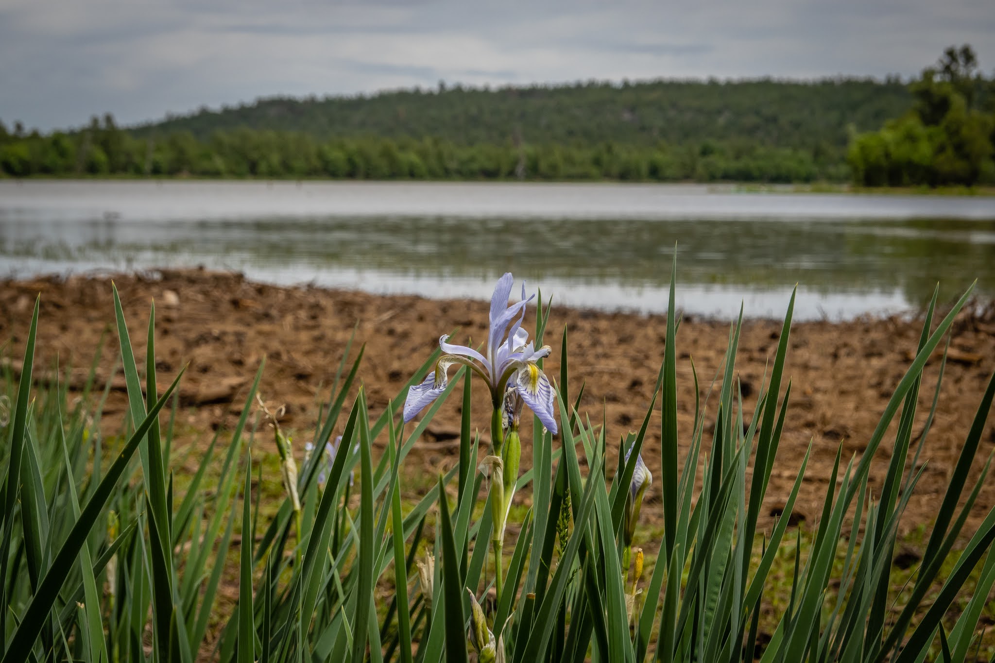
The next town of any significance was Alpine as we continued south on US 191. Our goal was to drive just far enough down this road - also known as the Coronado Trail - to enter Greenlee county and find a geocache. It turned out to be quite a pretty drive in the mountains. There seemed to be lots of forest roads and likely plenty of hiking trails as well. Our stop at an appropriately named cache, An Iris Meadow, brought us to a bit of a low lying area in the mountains. There were only a few irises still in bloom but we could tell it was likely spectacular several weeks ago. It was only a half mile walk down the forest service road to find the cache. It was the type of place we would really enjoy hiking - lots of pines and at 8100 feet of elevation pleasantly cool. But we had other things on our agenda.

Iris Meadow

A Remaining Iris

Back up to Alpine, I told Chris that it was only 7 miles to the New Mexico border, we didn’t yet have a geocache in Catron county NM either and there was one hidden less than 0.1 miles over the border. She humored me and said we could go for it. We had only gone a few miles when we were distracted by the National Forest service sign for a place called Luna Lake. We pulled in and found a spot overlooking the lake and enjoyed our picnic lunch. Being a Sunday, there were some people out but it was by no means crowded. We drove back towards the campground but stopped near the dam to do a short walk up to see the dam and lake. And then followed the outlet of the lake to look for another cache. Of course we were on the wrong side of the creek which varied in with from 5 to 15 feet. We eventually spotted a narrow spot with a few large rocks that allowed us to get across with dry feet. We never drove back into the campground but the area looks to be an interesting place to stop. Something else to add to our list.

Dam at Luna Lake


Heron in Search of Meal

We decided to head back to the Timber Mesa Trailhead but this time bringing our mountain bikes. We knew we couldn’t handle the main trail but thought the fire road that to the west of the trail might make for a nice ride. Just a short ride down the road, we come to Jacques Ranch or what remains of the home - a couple of stone chimneys.  Since the home only burned down in 1953, they have a nice plaque with a picture of the ranch from earlier days. A bit further down the fire road, we come across a log cabin. It is only in slightly better shape with portions of the four walls still standing.

Jacques Ranch

Log Cabin 

The road turned out to be in reasonable shape for our level of mountain biking. The plan had been to go as far out as was fun, have lunch and then come back the same way. We managed to find additional fire roads and one led us to another geocache that hadn’t been found in over a year. After turning around, we decided to try following a different fire road to see if it would lead us back to the car. Unfortunately it dumped us back onto Penrod Road. After a few miles on a very busy road with little to no shoulder and much of the traffic being trucks, we saw a side road that had a means to get thru the barb wire fence. It looked like it might head back over to the original fire road. This worked for only about a quarter mile before it ended at another fence line. With limited choices, we opted to walk the bikes about another quarter mile thru the sparsely wooded field. There were spots where the brush was too thick so we needed to find a different route but after 20 minutes, we could see the fire road. It wasn’t the most graceful end for a bike ride, but that’s how it works out sometimes.

Reasonable Fire Road

Our Bike Route

Several days later, we head back to Pinetop for another hike. AllTrails list the Country Club Trail as a 3.4 mile easy loop. As we start out on the trail, in the shade of the many pines trees is a herd of cattle watching us go by. We know we have a geocache nearby and hope we don’t need to shoo a cow that is guarding the cache. It’s a very pretty walk albeit a bit dusty. Lots of butterflies were flying around and I managed to have one sit still long enough to get some pictures. When it did fly away, it headed right towards me and landed on my water bottle holder and stayed put long enough for Chris to get a picture with her phone.

Relaxing Cattle

Butterfly


My Water Bottle Carrier Attracts Butterfly

Just over a mile into the hike, we came upon a side trail marked as Vista Point/Pat Mullen Mountain. We seem to be suckers for this type of diversion and it’s only 0.5 miles to the top. It only rises about 250 feet over the surrounding area so calling it a “mountain” might be a bit of a stretch. There were plenty of flowers in bloom and was a pretty walk to the top. There really isn’t much of a view from the top since the tree density if pretty high, but we can get glimpses of the distant landscape. The nice thing we are discovering about the trails in this part of Arizona is how well marked they are. There seem to be plenty of the diamond shaped “White Mountain Trailsystem” signs on the trees to show the way. Plus about every quarter mile is lettered and numbered diamond that designates where along a trail you are. Each trailhead has a map that shows the trail along with all the marked spots. The theory is that if something were to happen and you needed to call for help, telling them you are at “C17” would let them know you are at the top of Pat Mullen Mountain. Hopefully we won’t need to test their system.

Vista Point Intersection

Flowers Along Trail

At the Top of Pat Mullen Mountain

Partial Distance View Along Trail

Along the trail we also come upon numerous gates to get through the barbed wire fencing that separates the various areas for cattle grazing. It’s not clear when we go thru one whether we are on the side with cattle or without. I suppose it could also be the cattle are moved from one side to the other to prevent overgrazing of the land. Or maybe it’s just used to keep Bob’s cattle separate from Ted’s. Or more likely I think too much when I’m hiking! We were hiking on a Sunday and plenty of others were out doing the same. We also came across several mountain bikers and realized just how nice this trail would be for that activity as well. Between the side trip up the mountain and going for a few geocaches a bit off the trail, we turned the 3.4 mile loop into about 5.5 miles but would still consider it as easy.

Pretty Moth

Gate Between Plots of Land

Small Pond Area

Country Club Trail Tracks

Someone at the resort had mentioned the Maverick Trail as a possible option for mountain biking. After a little investigation, we discover this is mainly an ATV trail that starts west of Show Low in Clay Springs and heads east and south to near Pinetop-Lakeside. Being 50 miles in length, we know we need to limit the scope of our adventure. We pick a starting point near Little Mormon Lake since it was fairly close to the resort and arbitrarily head east. There are cattle guards that need to be crossed but they are easy enough if you don’t go too slow. Like most ATV trails, especially in Arizona, the trail is dusty with a few rocks to navigate around. Of course we had barely gone a quarter mile when we hit an extremely rocky section. Even though it was a relatively flat section of trail, it was nearly impossible to bike a speed that allowed us to get thru the rocks. For the next mile or so, we ended up walking our bikes more than we rode them.

Cattle Guard

Maverick Trail Started Out Okay

We knew we didn’t want to do much more trail like this but instead of turning around, we headed over a side trail off the Maverick Trail that took us past Little Mormon Lake. There were a couple of people camping in the area although the lake itself didn’t look too appealing. At least this got us onto the paved road and we could head back to the Jeep. As we were headed north, we saw an area to the west of the road that had a dirt road that looked reasonable and we suspected there were several geocaches in that direction. At the entrance to that dirt road is barbed wire gate that requires a bit of effort to open and close. As we were going thru, a pickup truck pulled up and came thru as well. We talked with the guy about our trouble with rocky portions of the Maverick Trail. He mentioned other sections that aren’t too bad and even back where we parked, had we headed west it would have been much better. He warned us he was coming out with a buddy to do some target practice but told us where they were heading and we realized it wasn’t where we were heading. It was actually a nice section for a bike ride and we found the few caches hidden in the area. When we got back to the car, we headed on the Maverick west and did find it to be much easier for biking. Our haphazard route came in at 7.5 miles.

Little Mormon Lake

Cache Location Near Rock Outcropping

Pretty Day for a Ride

Maverick Trail Route

The next day we head back to Pinetop-Lakeside to do the Springs Trail (not far from the Country Club Trail). The intention was to do it as a bike ride but it turned out to be a very rocky single track at times and only made it a half mile or so before turning back. Fortunately we had planned on that possibility and brought hiking boots as well.

The Rocky Section

The Springs Trail is much easier as a hike. There were definitely spots where biking would have been fine and even preferable to hiking, but there were enough spots where biking was going to be too much of a challenge. Along the way, we saw signs for timber harvest happening ahead. Usually we have found this to just mean the area has been marked for cutting but nothing is going on. So we were surprised to see workers actually performing a harvest. I’ve always wanted to drive a skidder but doubt they would let me take a shot at driving it!
Skidder at Work

A mile or so along the trail, we come across a few other hikers and they suggest we check out the nearby Old Hatchery Trail. Since our intended hike was less than 4 miles, we figured we could spare the extra distance to explore. It was a worthwhile side trip. We found a spot overlooking what appears to be a large holding pond to enjoy our lunch. A bit further in we found some of the old concrete raceways that made up the hatchery. The hatchery dates back to the 1930’s but given the size of the trees growing here, I suspect the hatchery hasn’t been operated decades. Eventually the Springs Trail parallels the Blue Ridge Trail with a short connector. This was a pleasant 6.5 mile loop with a side trip.

Well Marked Spur to Hatchery

Our Lunch Spot

Pretty Flowers

Former Hatchery Concrete Raceways

Runoff From Spring

Another neighbor at the resort let us borrow a few books with ATV trails in Arizona. Many of the trails aren’t anywhere near Show Low, but one sounded interesting and started in the town of Heber about 30 miles west of Show Low. The Black Canyon Auto Tour is just over a 15 mile drive along a dirt road. We first stop at a ranger station to pick up the “Journey Through Time Auto Tour” pamphlet. Reset your trip odometer at the start of the drive and then simply follow the program stopping at each identified mileage. There do seem to be signs at each stop but not all were prominent so I’m sure we would have otherwise missed a stop. At some of the stops, you must use your imagination. For instance, the original ranger station has long since burned to the ground.

The next stop was at a section of rocks where numerous pictographs are visible. These are different than petroglyphs in that the former are painted on the surface whereas the latter are carved or pecked into the rock. In theory they are visible from the road, but climbing up a short but steep and rocky trail leads to a much closer view.

Pictographs on Underside of Ledge

More Pictographs


Stop #3 is at the Black Canyon Rock Shelter. This one requires about a quarter mile round trip walk to see. We initially went looking for a nearby geocache so we missed the trail that goes up the side of the hill to the rock shelter but we backtracked and spotted the trail up. It’s not nearly as impressive as the cliff dwelling in Mesa Verde but it was still neat to check out. A few swallows had their nests in the ceiling of the dwelling. And we not too pleased to see us invading their space. Even though we are only 40 feet or so above the surrounding land, it still provides a nice view.


Rock Shelter

View from Rock Shelter

Several geocaches got us to make a few additional stops. One cache was hidden by a unique rock formation and name “Turtle Rock” for obvious reasons. Another was near a cemetery for member of the Baca family. There is a very sturdy fence surrounding the headstones for good reason. Just a couple hundred feet away was a group of a few dozen open range cattle. They kept a close eye on us as we searched for the cache.

See the Turtle?

Bee Coming in for Landing

Heading back Saloon Canyon for Cache

Baca Family Resting Place

Cattle Suspicious of Us
Another site that isn’t an official stop of the auto tour is Black Canyon Lake.its a pretty spot with a man made lake of about 78 acres. There seemed to be a trail on either side of the lake, but it didn’t appear that they connected at the far end. We did a short walk along the western shore and enjoyed the views. There were a couple dozen other people out enjoying the area fishing, picnicking or even on some stand up paddle boards with two dogs seemingly enjoying the outing. We can only imagine how petrified our dog Shelby would have been if we had tried that with her!

Black Canyon Lake


Our last official tour stop was at a gravesite for three young men accused of stealing horses back in the late 1880’s. The trail starts near the Black Canyon Rim Campground and heads down an extremely rocky trail. We often found it easier to just walk in the woods parallel to the trail. Probably not worth the effort to get here but we fell for it. Over all, this auto tour was a nice diversion from a our typical hike or bike ride and took us to a very pretty area of Arizona.

Very Rocky Trail

Supposed Horse Thieves' Resting Place