Monday, May 31, 2021

Cicadas in Kodak

Map of this blog's locations click this link to open the map

Back in late February and early March while making our travel plans for the year, we had found two spots in the Asheville North Carolina area for two months each. This would cover us for all of June, July, August and September including 4th of July and Labor Day, but Memorial Day was still unplanned. One thing we have come to realize in our travels is, its best to have the major summer holidays planned and booked in advance. With this holiday occurring just before our stop in North Carolina, we wanted a campground that was near our intended route and a reasonable drive to Asheville.

There were lots of possible choices but one town in Tennessee caught our eye. Kodak Tennessee is about 20 miles east of Knoxville and just off I-40. Since we had both worked at Eastman Kodak and met each other there during our co-op years, Kodak holds a special place in our hearts. While maybe an unusual way to select a place to stop, we found a couple of county parks in Kodak next to the Douglas Dam that had decent reviews and availability. We picked a site at Douglas Dam Tailwater campground and booked it for the 4 nights we needed.

It’s only 125 mile drive from London to Kodak and reasonably easy being interstate most of the way. The traffic around Knoxville wasn’t too bad. Even though we were arriving on the Friday of a long holiday weekend, there wasn’t a long line entering the campground either. It was a warm sunny afternoon when we arrived and Chris went in to register. When I came out of the rig to unhitch the Jeep, I heard a strange noise. Since the motorhome was still running, I initially thought it was making the noise and I went back to investigate the engine. But it sounded normal, then I realized the sound I was hearing was from the Brood X cicadas. The nearby trees were full of them and they were causing a racket. We had actually seen a couple cicadas back at Deer Creek State Park in Ohio the morning we were pulling out and had assumed we would find them at our stop in London Kentucky, but had lucked out since they hadn’t emerged there yet. Well I guess our luck had run out.

Cicada Looking for Love

On the Hood of Jeep

Douglas Dam Tailwater campground has 60 sites and is situated on the downstream side of the dam. Many of the sites are waterfront but ours was next to a heavily treed hill. This meant our site wasn’t as level as we would like, but using all of our leveling blocks we managed to get setup. The story of the town of Kodak is interesting. Back in 1892 when this town was being created, the local postmaster heard about the new Kodak camera. He liked the name Kodak and got permission from George Eastman to use Kodak for the town’s name. While not the original post office building, we did stop by to get our souvenir picture. (We went on a Sunday to avoid looks from locals!)

Chris & Jack Come Back to Kodak

There aren’t any trails on the tailwater side of the dam, but we can walk the park roads to get in some dam sightseeing. From the campground level, you can get a good look at the dam. There are a fair number of day use visitors in the park fishing along the outlet. Signs warn about rapidly rising waters when there is a release through the hydroelectric power plant. We would occasionally hear warning sirens but never went over to check out the change in water flow. This would have been much easier if we had a waterfront site.

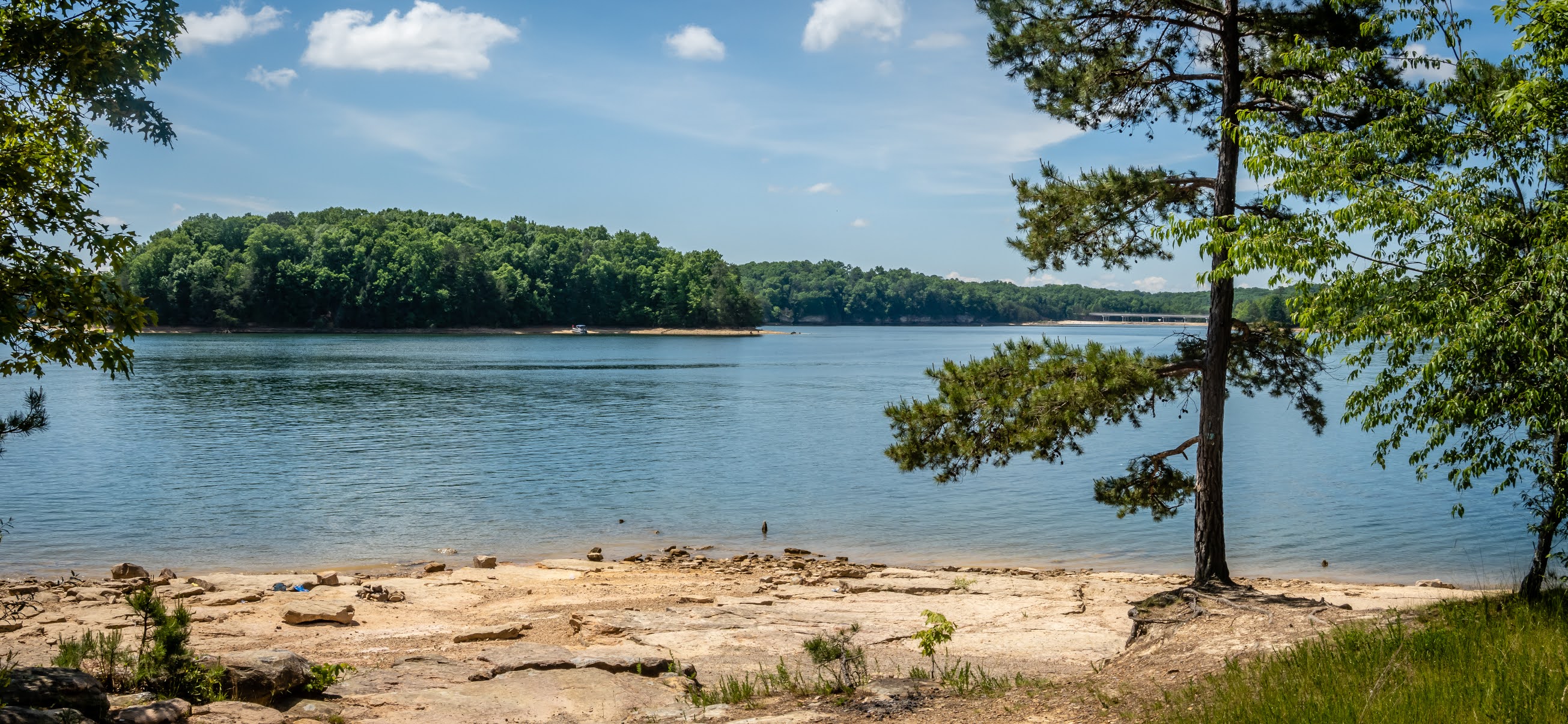
Douglas Dam from Tailwater

The road out of the campground is a pretty good climb going up 350 feet in the mile it takes to get up the the overlook picnic area. Maybe we should have been like everybody else and drove, but we wanted a bit of exercise. There are lots of information signs that describes the construction and operation of the dam. Douglas Dam is 201 feet high and 1705 feet across. Possibly the more impressive fact about this dam is it was built in just 384 days back in 1942-43. The dam creates Douglas Lake with a shoreline of over 500 miles.

Looking Up at Overlook

Clouds Rolling in at Douglas Dam

Tree Full of Blooms

Down from the overlook is a pedestrian walkway that gets closer views of the dam and the power plant. Unfortunately you’re not permitted to walk across the dam itself to get to the Headwater campground.

Closer View of Douglas Dam

Power Plant at Dam

We spent the next day checking out another of the 29 dams in the Tennessee Valley Authority system. Cherokee Dam is near Jefferson City to the north of us. The drive had a couple goals besides seeing another dam. There is a hiking trail at the dam and by heading this way, would could find geocaches in two additional Tennessee counties. While it wasn’t the nicest of days, there were still plenty of visitors. Probably to be expected for Memorial Day weekend. On one side of the levee is Cherokee Lake. The other side has some of the parkland being used for agriculture with dozens of round bales of hay waiting to be collected. It was a nice walk with some pockets of woods and a few geocaches along the way. The red, white and blue mesh used to create the hay bales was a patriotic touch.

View of Cherokee Lake from Levee

View of Opposite Side

Holston River Flows from Dam

Patriotic Bales

By no means were we “getting used” to the cicadas. Fortunately we had some cool and even wet weather early in the stay so they were less active. They tend to hang out in trees that are in full sun and our site just happened to fit that category. When it was warm and sunny, the noise was obnoxious and they were everywhere around the rig. They seemed to like one of my bright yellow shirts and would swarm me when I was wearing it. Even though they are harmless, when one lands on you and tries to climb up your leg or neck, it is a bit startling. At one point, a cicada landed on my shoulder and started to make its noise. When they are only inches from your ear, the noise is unnerving. We had to be careful to avoid letting them in the motorhome. We would check our persons and the area by the door before coming back in. Let’s just say, I’m glad we weren’t staying here for a couple weeks.

For our last day, we drove over to the other side of the French Broad River to the Headwater Campground. This campground is just a bit larger than ours but much more crowded. Being the holiday weekend, besides campers, there were dozens of trucks with boat trailers parked on just about any grass surface. We had wanted to do a hike in the woods to immerse ourselves in the sound of cicadas. The Trotter Bluff Trail starts near that campground. It’s only a 1 mile loop but for what we intended, it should work fine. At the trailhead near the parking lot was a dead ash tree. Hundreds of cicadas were on its bare branches and more easily spotted than in a live tree with leaves. We watched for a bit and noticed that they tended to all fly from their spot at almost the same time, fly around for a couple seconds and land again. They constantly repeated this activity almost like they were playing some form of musical chairs.

Once on the trail in rather thick woods, the sound of the cicadas was nearly deafening. Maybe not quite as bad as spring peepers when you’re right next to their pond, but still very loud. The interesting thing was once we were on the trail, we saw no cicadas - not even on some of the understory trees. They were all in the upper canopy where the sun was shining at least 50 feet overhead. So we were actually able to enjoy the walk and not needing to constantly swat them away. At one point we sat down on a fallen tree and just listened. There seemed to be two distinct sounds. That of those cicadas in the surrounding canopy just over our heads and the thousands more further away from us. The large body of water near us obviously reduced the numbers. Maybe we should have picked a larger woods for our listening experiment. I put together a short video so you may experience the sights and sounds of the cicadas if they didn’t make it to your part of the world.


Lake and Headwater Campground

Looking Down French Broad River at Tailwater Campground

Thursday, May 27, 2021

A Week in Kentucky

 Map of this blog's locations click this link to open the map

As we were looking at our drive from Ohio down to Asheville North Carolina and trying to determine potential stops along the 460 mile route, we realized somewhere in Kentucky would work out well. We had heard good things about the Kentucky Horse Park Campground just to the north of Lexington and knew that area would be fun to explore. Unfortunately we were only planning 2 to 3 weeks out and the place was mostly full for our dates. We could have snagged a site for a night or two but we were hoping for 5 or 6 nights, so we continued the search and came up with a former Kentucky state park near London. Levi Jackson Wilderness Park seemed to have a lot going for it. Plenty of hiking trails and geocaches in the surrounding area, but most importantly, they had availability for the nights we were wanting. Washington Court House to London was a bit further than we wanted to do in a day so we scoped out the Cabela’s in Lexington as a simple overnight stop along the way.

The drive is basically down I-71 but there is construction on the bridge between Cincinnati and Kentucky which has that route completely closed. The detour on I-471 and I-275 was not that much longer but there was a lot of traffic since all southbound travelers take the same detour. It wasn’t the most relaxing 185 mile drive but not terrible. We pulled into the Cabela’s and headed to the side of the building that has the designated RV parking spots. Unfortunately there were a handful of storage containers and a semi with trailer in those spots although the RV dump station still seemed to be open. We found an out of the way spot away from the store and parked.

Chris had scoped out a Chuy’s Mexican restaurant only a mile or so away. Since we are fully vaccinated, and starting to get comfortable with eating indoors, and Chuy’s is one of our all time favorite restaurants, we headed over even though it was a Friday night. The wait wasn’t too bad and the indoor seating was still at some reduced level with plexiglass in between the booths. The food was excellent and it felt so nice to be able to get back to some semblance of normal. While we were there, I happened to determine that their was a Graeters Ice Cream shop less than a mile from us. Even though we were stuffed, we headed there for desert although we brought it back to the rig and put it in the freezer to eat as a before bedtime snack. I got out the next morning to get a few caches in two of the surrounding counties and saw some of the gorgeous horse farms in the outskirts of Lexington. We definitely need to better plan for a longer stay in the future.

We only had an 80 mile drive to Levi Jackson and had some time to kill before we could check in so we made a stop in Berea at the Kentucky Artisan Center. We have stopped here years ago and knew they had proper parking for RVs or tour buses. They still allow overnight parking but one must arrive before the center closes in order to fill out a form and get a window sticker so you don’t get hassled by the local police. We were only staying for lunch and to check out the center long enough spend an hour or two. It is a neat stop and there is all sorts of unique artwork on display and for sale by locals. We enjoy this type of stop since we don’t have room in the rig for this type of stuff. This way we can briefly enjoy the art but not have to store it for travel.

T-rex at Kentucky Artisan Center

Entrance to Artisan Center

Need Some Fish Art?

Levi Jackson Wilderness Park is just outside of London Kentucky and all the signs on the nearby roads refer to it as a state park. That’s because up until 2019 it was a state park but has now been transferred to the city of London. Coming in on a Saturday afternoon meant there were lots of people out and about but I got the rig into our site without incident. The setup of the park is such that the water and electric are in between every 2 sites. Our neighbors were already there and had claimed the 50 outlet so we were left with the 30 amp - not a big deal for the 6 nights we would be staying there.

The park was nearly full predominantly with travel trailers and a few fifth wheels. There might have been one or two other motorhomes. Many of the sites turned out to be monthly or seasonal rentals. After the weekend was over, the park quieted down during the day but when locals got through with work they would come back to their trailer and spend the night. Of the 136 sites in the campground, only 20 of them are full hook up so we would frequently see people pulling their “blue boys” behind their golf carts to go to the dump station. There was also a pumper truck that frequently made its rounds thru the park to empty the holding tanks.

On Sunday we decided to check out some of the attractions located within the park. There are several trails throughout the park but we just walked some of the park roads to get to the Mountain Life Museum. It sounded like an interesting stop but it wasn’t open. The best we could do was look onto the grounds to get a sense for what was there.

Part of Mountain Life Museum

Big Toad

We continued down the park road a quarter mile to check out McHargue’s Mill. While not the original mill, this reproduction was built at the present site by the CCC back in the late 1930’s. The original was a water powered grist and saw mill. This one is situated nicely at a small waterfall and being over 80 years old, it looks pretty authentic. There are dozens of old mill stones lining the walkway from the parking lot to the mill with all sorts of interpretive signs explaining how the mill worked. It’s quite a pretty setting and worth the stop. From here we picked up one of the many trails in the park to head back to the campground. There were several geocaches hidden along the North Boone Trace Trail that got us back to camp but we realized we had 7 more caches if we were to continue the trail to the southeast of camp. It turned out to be a 4.5 mile hike and was a rather pleasant one.

McHargue's Mill


Mill with Water Fall

When looking for other hiking in the vicinity, we discovered one in AllTrails named the “Hawk Creek Valley Suspension Bridge Trail”. Just it’s name made us want to give it a try. Turns out this named 4 mile out and back trail is part of the longer Sheltowee Trace trail. This 319 mile trail starts in northern Kentucky maybe 15 miles south of the Ohio River and wanders thru various national forest land in central Kentucky before crossing into Tennessee for another 45 miles or so. The trailhead is about 12 miles west of camp so we packed a lunch with the plan to drive a bit beyond the parking area in order to get a caches in a couple other Kentucky counties. The trailhead is in a rather out of the way location, but there was one car already parked here so we knew we wouldn’t be alone. We had our lunch then hit the trail heading north.

Hawk Creek Trailhead

It was a very nice trail that passes thru fairly dense forest land. Lots of large hemlock trees and the mountain laurels were in full bloom. Their bright white blooms would show up quite well in the forest understory. After a bit more hiking, we hit an area of the trail with large rock walls rising out of the ground. It was very fun to walk next to these walls. Some of them were dripping water and had all sorts of mosses growing on them. They actually provided a nice cooling effect as we passed by.

Mountain Laurel Blooms

Nice Wooded Trail

Mountain Laurel Bloom Progression

Tall Rock Wall Along Trail

Staying on the Sheltowee Trail

Mossy Rock Wall

As we approached the 2 mile point of the hike, we were adjacent to Hawk Creek and knew the suspension bridge would be up ahead. Comments left in the AllTrails app indicated that the suspension bridge was damaged and could not be used to cross the creek but we still wanted to check it out. Plus there is a geocache just on the other side of the creek. It was last found in October of last year but prior to the bridge being damaged. I had hoped to be able to weave my way thru the fallen tree branches to get over the bridge to find the cache. When we got to the bridge, we were amazed by just how large the bridge “had been” and by how much damage a large tree falling squarely across the middle of even a well engineered bridge could cause.

Hawk Creek

Smooshed Suspension Bridge

Another Bridge View

Hawk Creek was flowing at a moderate rate and it didn’t look all that dangerous to cross. But I really didn’t want to get soaking wet boots for the 2 miles back to the car. After exploring the edge of the creek, I spotted a spot where I figured I could get across and stay dry as long as I didn’t slip and fall in the process. It took a few minutes of careful foot work but I made it across with no water in the hiking boots. The view of the bridge from the other side was a bit more open and looks like it could be used for 20 feet or so before it twists 90 degrees at the fallen tree. I was having all sorts of troubles locating this cache but given the effort to just get here, I realized I wasn’t willing to come away empty handed. I eventually ignored my GPS and followed the helpful hint and made the find. I suspect this one will not be found as frequently now that the bridge is out. And based on the elaborate construction and amount of damage, this bridge will likely be out for quite some time. The hike back was pleasant and non-eventful, just like we like them.

Bridge from Opposite Side

Fallen Tulip from Yellow Poplar

We thoroughly enjoyed the hike on the Sheltowee Trace, so we checked out more options that were in the vicinity. One option was to simply go back to the same trailhead as yesterday but follow the trail to the south, but there was another section of it called “Van Hook Falls and Cane Creek Valley” that had some good comments in AllTrails. The trailhead for this section is a bit further southwest of camp and about 18 trail miles further south than where we just hiked. This hike is listed as just under 6 miles out and back so we ended up bringing along our lunch and packed them in our Camelbacks.

Sign at Van Hook Falls Trailhead

We thought the Hawk Creek hike was wonderful but this one is probably even better. There aren’t as many interesting rock formations but there are some rock outcroppings along the trail. What made this hike even better were the numerous waterfalls along the trail. We knew there was Van Hook Falls at the turn around point but were surprised to find others along the way. We timed one of the falls perfectly. There was a small opening in the thick forest canopy that happened to be letting a stream of sunlight hit the falls perfectly. We stopped on our return trip and the mood was completely different without the spotlight effect by the sun. As we approached Cane Creek, there was one location where there was a tricky drop-off to negotiate, fortunately there is a heavy rope tied to a tree to safely pass.

Sunlit Falls

Trail Follows Large Rock Wall

Rope to Get Up/Down Drop-Off


At Cane Creek, the forest doesn’t completely shade the rocks along the creek. We realized there were many dozens of butterflies flitting around this part of the creek. We spotted three distinct species and with a little after-the-fact sleuthing was able to identify them. The medium size butterfly has a very different patterns on the two sides of its wings. I believe these are called red-spotted purple butterflies. I guess an appropriate name. The smaller ones we found were sort of a pale blue and they seemed to like hanging around the waterline of a small puddle in the rock. I think these are called summer azures or possibly spring azures.

Cane Creek

Red-spotted Purple Butterfly

Wings Up, Wings Down - Different Look

Small Summer (or Spring) Azures at Puddle

By far the most interesting ones to us were the eastern tiger swallowtails. We have been seeing lots of this species on our hikes recently, but this was the first time we found so many in one small location. Chris had spotted a couple dozen of them in the partial shade under a bush. They seemed to be feeding off the moss covered rocks. This activity turns out to be called puddling. They are feeding on the salts and minerals that have leached from the soil. I was surprised by how close they let me get although at one point they did decide I was a threat and flew off. It was quite a unique sight. Sorry for so many pictures but most times I am only able to take one or two pictures of a butterfly before it moves on.

Six or More Tiger Swallowtails "Puddling"


There is a bridge to get us across Cane Creek and  this one hasn’t been destroyed by a fallen tree. There were some interesting rock formations just on the opposite side of the creek as we head to the falls.

Bridge Over Cane Creek

Trees Clinging to Overhang

Another Rock Wall Along Trail

It was probably a quarter mile from Cane Creek back to Van Hook Falls. A very nice viewing platform has been built opposite the falls with a fancy bench to relax while you enjoy the views and sounds. The water was flowing moderately. I suspect this would be even better earlier in the spring or after some heavy rains in the area. It worked out nicely as our lunch spot. It is possible to safely get over to the falls and even stand behind them. After enjoying the spot, we turned back and headed to the parking area. This turned out to be one of the better hikes we have taken recently and rates highly compared to some of our other favorites. Well worth the visit if you get the chance.

Pretty Bench to Relax While Watching Van Hook Falls

Van Hook Falls

Colorful Shelf Fungi Along Trail

The following day we needed a break from the hikes so we did some carefully planned driving in the Kentucky countryside in order to get caches in three more counties. We saw some really rural parts of the state that likely don’t get many tourists. Having that rest day allowed us to do one last section of the Sheltowee Trace. Chris had read somewhere about one section of the trail near the Laurel River Dam that was able to be mountain biked. We even found a YouTube video of a group of guys doing an 8 mile stretch of the trail. So we headed down with the bikes to the dam. There is a large parking lot on the south side of the dam but most of the people seemed to be heading to a small beach area of the lake formed by the dam.

Another Dam

Laurel Lake Side of Dam

People Flocking to the "Beach"

We biked north across the dam and found the trailhead for the Sheltowee Trace. For some reason this part of the trail system isn’t very well marked. There are many times where we intersect other trails or side roads to picnic areas and completely lose the trail or have several options and it’s not clear which is the one we want. We slowly make our way but are finding much of the trail, while fine for hiking, is a bit too extreme for our biking skills. Plus I was having brake issues so I needed to be extra careful to make sure I didn’t build up too much speed for the trail conditions. We eventually get to a spot overlooking the Holly Bay Marina and eat our lunch. We continue after lunch for another half mile or so before realizing it wasn’t as much fun as we had hoped and turned back. Instead of the planned 16 mile out and back, we only managed 9 miles.

Lake View Along Sheltowee Trace

Holly Bay Marina

A few days earlier, we had talked with some friends of ours and they mentioned we were very close to the birthplace of Kentucky Fried Chicken. We aren’t huge fans of the food at KFC but it sounded like a quirky place to check out. So we picked our route back to come thru the town of Corbin. It would allow us the chance for another cache in yet one more county. It turned out that while the drive thru for KFC was open, the indoor museum wasn’t (darn COVID). There are a few outdoor displays so we check them out and learn a bit about the man that started KFC - Harland Sanders. Our stay in London and Kentucky was coming to an end, we need to head to our last stop in Tennessee for the Memorial Day weekend before heading to the Asheville area of North Carolina.

Colonel Sanders First Business - A Service Station

Outside of Closed Museum