Map of this blog's locations click this link to open the map
The 150 mile drive to our next stop in Grand Teton National Park (GTNP) would take us south through Yellowstone NP, and through the majority of GTNP as well as several miles of federal land that separates the two national parks. The road construction we had driven through on the way to Gardiner nearly two weeks ago was still ongoing but at least an initial layer of asphalt had been put down so the drive itself wasn’t through dirt. There was still a long wait for the pilot car but it was tolerable. The plan was to stay in Gros Ventre campground on the south side of GTNP. It is a first come, first serve campground and they have several loops. One loop is for employees only and another for tent campers only. There are three loops we can possibly fit into: two are boondocking only while the other has electric hookups.We made it to Gros Ventre ( pronounced “grow vaunt”) right around 1 PM. The camp hosts said there was one electric site left but it was identified as 35 foot. Being 38 foot long, we told them we would do a quick drive by in the car to scope it out. We decided the spot would have been very tight for us so we passed and opted for one of the boondocking sites in the other loops. We were given a list of possible sites that we should fit in and did a drive around to check them out before settling on one of them.You can stay in the park up to 14 nights but our plan was for just 10 nights. The cost seems a bit high to us but the benefit is the location within the park - it’s not too far from Jenny Lake inside the park and the town of Jackson Wyoming just a few miles to the south. Boondocking is $30 per night while electric is $55. We typically spend less than $4 a day in fuel to run our generator when boondocking but the convenience of an electric site and not needing to deal with the generator seemed to be worth it to us. If you want to get a site in the electric loop, plan on getting here at 8 AM if you have a larger rig. If an electric site isn’t available, the hosts told us the process here is to pay for a boondocking site one night at a time and show up to get in line before they arrive at the office the following morning. If you’re lucky, somebody with a larger rig will check out and you can snag their spot. If one isn’t available, just extend your boondocking site another night and try again the next morning. It’s not a convenient system but it works. Chris got up early the next morning and was third in line and managed to get an electric site that we could fit into.Like many travel days, we didn’t feel like doing much after we got settled in our first spot. We did a drive up a dirt road that leads to Mormon Row (more on this later) but we ended up getting stuck in a very long bison jam. There were well over 100 of them and they were on either side of the road. It seemed like all the bison on the left hand side wanted to be on the right and vice versa. It led to us being trapped for twenty minutes or longer. Finally some larger utility truck came up from behind us and simply drove towards the ones blocking the road and amazingly, they got out of the way.
 |
| Bison with Tetons |
After getting moved to our electric site on the second day, we headed into the town of Jackson to check it out. This is definitely a touristy type of town. And while we typically don’t enjoy this atmosphere, it was entertaining. We stopped at the visitor center to see if there was any other info about the area that looked interesting. There is a large elk refuge in town so the displays had that as the main theme. We also wandered around the downtown area of Jackson. The main square in town has a small little park with lots of people out and about. The entrances at the four corners of the park have unique elk antler arches to walk through.
 |
| Unique Racks |
 |
| One of the Streets in Jackson |
 |
| Antler Archway |
Now that we were situated in our electric site, we head out for a bike ride the next morning. There is a nice paved bike path all along US 89 from Jackson up to Grand Teton Park. While it would be possible to bike from Gros Ventre Campground to this bike path, the road is narrow and has no real shoulder. Plus they were starting some big construction project on this campground road so we figured it would be easier and safer to simply drive to the parking area near the bike path which would also save us 5 miles of riding each way. The ride along the bike path is quite beautiful with the Teton Mountains off to the west. They are about six miles away, but are so large that they appear much closer. The airport is next to the mountains as well and it is odd to see large commercial jets coming in for a landing with the mountains behind them.
 |
| View of Tetons from Bike Path |
The bike path has a turn into the park and continues all the way up to Jenny Lake Visitor Center. We have no plans to go that far on our bikes. We had wondered if GTNP had any entrance stations where you need to pay or show your pass. When we had driven down from Yellowstone and into GTNP, we had not seen an entrance station southbound. Although there is one to enter Yellowstone when heading northbound from GTNP. When we had driven in and out of the park to go to Jackson, there were no entrance booths either. We discovered that there is one shortly after heading into the park towards Jenny Lake. Even the bike path had a sign about showing the ranger a pass but she waved us on before I could dig ours out of my wallet.A quarter mile from the entrance booths was a turn to the Chapel of the Transfiguration. We didn’t know what it was but sounded like something we should at least look at. The log cabin chapel was built in 1925 and has a jaw dropping view of the mountains behind it. There is probably room for 50 or so people inside but there are outside benches that can be used if the weather is nice. It was quite a nice little chapel.
 |
| Chapel of the Transfiguration |
 |
| Exterior Pews |
 |
| Stained Glass |
 |
| Window Behind Altar |
Nearby are a few other old buildings associated with Menor’s Ferry which operated in the late 1800’s until the 1920’s. There is a cabin that is now the “general store” and does have a few things for sale. A reconstructed double pontoon ferry boat is on display with signs explaining how the ferry operates without any motor aboard. We then continued back to the main park road and biked a bit further before realizing we should turn around since the wind wasn’t going to be our friend on the way back. We made it back to the car getting in a 17 mile ride.
 |
| General Store at Menor's Ferry |
 |
| Reconstructed Ferry |
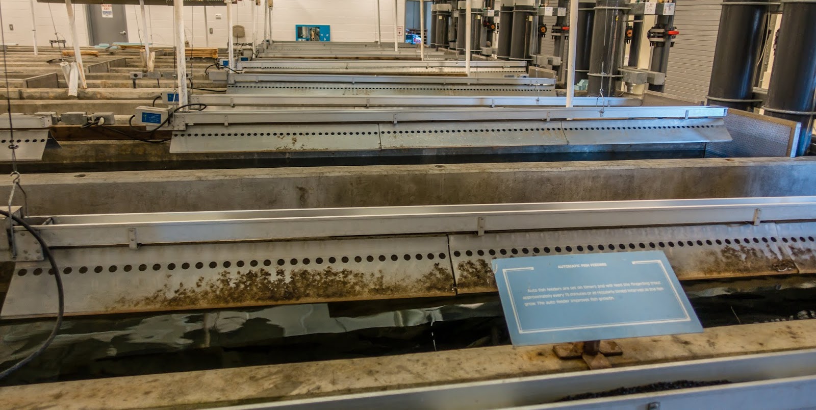
We headed back into Jackson to check out the farmer’s market. Unfortunately, it turned out to be what so many of these markets seem to be anymore - mostly crafts and not many vegetables and fruits. On the way back from town, we stopped at the Jackson National Fish Hatchery. It isn’t a very big facility but the volunteers gave us a nice tour and told us all about the trout that are raised here before being released into the wild. We ended up talking with the one volunteer for some time. She and her husband stay in their RV on site and alternate work with one other couple for the season between Memorial Day and Labor Day. We swapped our travel stories and got a little insight into this volunteer gig.
 |
| Holding Tanks at Hatchery |
 |
| Small Trout |
 |
| Pond at Hatchery |
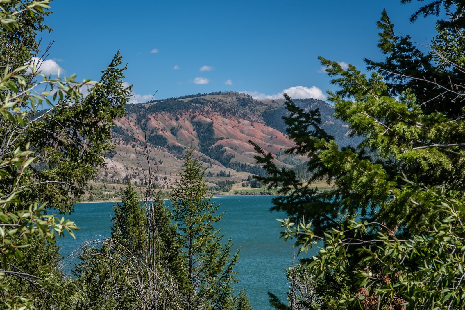
The next day was Sunday and even though we have done very little within GTNP, we figured we would skip the park on this busy weekend day and check out other things in the area. Our route would take us east of the campground thru the very small town of Kelly with a population just over 100! We then continued east along Gros Ventre Road. The road ends up being gravel and starts out in reasonable shape but gets rough and bumpy not too far along. Our main destination was to go for a geocache or two hidden out this way. There was one cache that had been hidden just over two weeks earlier but had not been found yet. Admittedly, there probably aren’t that many local cachers and most visitors have a limited timeframe to visit the park so they aren’t inclined to drive 15 miles on a very bumpy road to look for a geocache. Of course we have the advantage of being here for some time and a Jeep that can handle the bad roads. There was a nice lake along the way and lots of red hills that made for a striking view as we drove further out.
 |
| Overlooking Lower Slide Lake |
 |
| Red Hills |
We got to the small parking area next to the trailhead and saw another truck parked there. We wondered if another geocacher was going to beat us to the cache for the “First To Find” before us. It was a fairly short hike to the cache location and we didn’t see anybody else along the way. The views near the cache location were pretty astounding. The red from the nearby hills with the Tetons about 20 miles away in the background. It’s not a view many visitors to the area will get to experience but was well worth the drive out. To top it off, we did manage to find the cache and were the first to find and as of this writing nearly 2 months later, we are still the only ones to log a find for this cache.
 |
| Red Hills with Tetons in Background |
The road seemed to continue on but we decided to start heading back and stop at a few sights we had seen on the drive in. The first stop was at Atherton Creek Campground on Lower Slide Lake. Surprisingly, there seemed to be a couple sites in the campground that we might be able to fit our rig in although we might not be willing to drive the bumpy road to get here. We found a picnic table at one of the empty tent camping sites with a great view over the lake. We had just sat down to eat our lunch when the campground host drove up in his golf cart. I was afraid he was going to chase us off since we weren’t paying for the site, but he had no issue with us using it as our lunch spot. After lunch we noticed a couple of wind surfers out on the lake. It was an extremely windy afternoon so we headed down to a closer spot on the shore to see how wind surfing is done. They weren’t doing any crazy jumps but managed to stay up on their boards for the most part.
 |
| Splash |
A bit further down the road we stopped at a pullout for the Gros Ventre Slide. Back in 1925 a huge landslide occurred and an estimated 50 million cubic yards of stone and soil, 1 mile long and almost a half mile wide, came crashing down and formed a dam over 200 feet tall creating a lake behind it. The dam held for almost 2 years before part of it gave way sending a wall of water downstream destroying lots of property and killing 6 people in the process. It was very reminiscent of our recent stop at Earthquake Lake near West Yellowstone. There is a short walk thru the area of the slide although being over 90 years old, it wasn’t as easy to see what had happened since Mother Nature has done a good job of reclaiming the area. One last stop for another cache brought us to a place known as the “Marrying Tree”. The two trees form a bit of an arch with a view of the Tetons in the background.
 |
| Debris from Landslide |
 |
| View of Lower Slide Lake from Landslide |
 |
| Marrying Tree |
I woke up the next morning to a beautiful sunny morning. As I walked to the restroom, I noticed lots of people standing around the campground road with cameras and cell phones. It wasn’t until I came around the corner of the building that I saw three bull moose walking thru our loop. I went back to the rig to get my camera and long telephoto lens. They were slowly working their way over to the Gros Ventre River that’s on the back side of the campground. They were only there for 10 minutes but it was quite the sight.
 |
| The Three Amigos |
With the weekend behind us, we headed into GTNP for a real hike - Jenny Lake Loop. We have done this hike before although it was back in 1984 right after graduation from college. I can’t say I remember much from that hike 35 years ago so this will seem like a new hike to us! The loop will be at least 7.5 miles but one section of the trail is closed because of a rock fall. There are a few other side detours along the way so we knew it would be a long hike. The parking lot was quite full but we found a spot along the shoulder of the entrance road to the visitor center there. We started the loop near the boat dock with the plan to head clockwise around the lake. The trail was initially quite busy. Seems like lots of the visitors will head in this direction to get some pictures but after a quarter mile or so, the crowds thinned out a little.
 |
| Entrance Sign at Jenny Lake |
It was along the western edge of the lake where the trail that goes closest to the lake is closed. This means the the alternative route will climb in elevation to be uphill of the rockslide. It was fine since the views were better from higher up. Plus we planned to visit Hidden Falls and Inspiration Point, both of which are at a higher elevation, so we would be heading up regardless. In the vicinity of Hidden Falls, we started to see groups of people with helmets and climbing gear. Apparently there are some guided climbing tours but I couldn’t convince Chris to sign up for one.
 |
| Trail Above Jenny Lake |
 |
| Look Closely for Climbers |
The falls were definitely hidden in the sense that it was tough to get a good view of them. Plus lots of people we’re at the small viewing platform. Initially it wasn’t clear why so many people were here. The trail hadn’t seemed that crowded. Turns out there is a shuttle boat that takes visitors from the visitor center to a dock a half a mile away from the falls. It saves them 2 miles of hiking with beautiful scenery for an $18 boat ride.
 |
| Hidden Falls |
Further up from the falls is Inspiration Point. This one requires a pretty good climb and even the boat people were finding it a challenging climb. The views from up here are worth the effort though. We wandered away from the crowded spot and found a more secluded place to have our lunch while watching a group of climbers across the way. Rather than taking the trail back towards the boat dock and continuing around the lake, we headed out the Cascade Canyon Trail for a quarter mile or so before finding a newer trail that heads back to the lake. It wasn’t a shortcut but it did keep us from backtracking and also eliminated most of the crowds. Once back on the trail near the lake, we enjoyed the walk and the views only coming upon a few groups of other hikers.
 |
| View from Inspiration Point |
 |
| Lunch Spot View |
 |
| More Climbers |
At one point, I noticed something moving to our left. There was a young bull moose about 12 feet off the trail eating some shrubs. We stopped and watched it for a minute trying to decide what our options were. We knew not to get too close, but there really wasn’t a good route around the moose. Then we saw some people heading towards us from the other direction. They hadn’t seen the moose yet so I used hand signals to let them know what they were about to walk in to. They saw the moose and were even closer than we were so they backed up a bit and evaluated their options as well. In all this commotion, I realized that while the moose had seen the four of us, it didn’t seem at all interested in anything other than eating. So we decided to walk past him while keeping an eye on him. We got past without any issue and talked with the other couple when we all noticed another family heading our way. The grandfather and grandson we oblivious to the moose and didn’t understand our warnings until they were right next to the thing. When they did see it, they were quite startled but fortunately the moose stayed calm and let them pass without incident. For the next 15 minutes, we warned other hikers heading around the opposite direction to keep a close eye out for a moose.
On the north end of the lake, we came upon a fairly wide creek flowing into the lake. We looked to see if there was some sort of series of rocks or fallen logs that we might be able to use to cross the 100 foot creek, but opted to stay on the trail that goes up to String Lake just above Jenny Lake where there is a pedestrian bridge to easily cross the water. This “detour” adds over a mile to the hike but at least we stayed perfectly dry. Who knows what would have happened had we tried to cross creek? The rest of the hike was less interesting especially since it is near a road and parking area for a bit of it but there were nice views across the lake. Our hike came in at nearly 10 miles and 1300 feet of elevation.
 |
| The Creek We Didn't Cross |
 |
| View Back Across Jenny Lake |
 |
| Our Jenny Lake Track |
We took a day trip heading west out of Jackson to go over Teton Pass. The main goal was to go over the border into Idaho to get a geocache in another county in that state. Probably not the best reason for the trip but it turned out to be a nice outing. The drive up State Route 22 was pretty. We stopped at a pullout that overlooks Jackson Hole. From here we drove over to Victor Idaho and had a nice lunch at Big Hole BBQ. We checked out town and found a geocache or two. We had noticed a hiking trail near the border of Idaho and Wyoming and while there aren’t any geocaches along the trail, we decided to give it a try. The road to the parking area starts in Idaho but the trailhead is in Wyoming. We did about 2 miles of a nice trail along Moose Creek before turning around to head back to the car and then the campgrounds.
 |
| Overlooking Jackson Hole |
 |
| Moose Creek Trail |
 |
| View Along Moose Creek |

The next day was another long hike. The goal was to hike around Phelps Lake in GTNP. The original plan was to park at Laurence Rockefeller Preserve and pick up the Phelps Lake Trail from there. When we arrived, the parking area looked pretty full and there was a line of cars that seemed to be haphazardly parked. As I attempted to get past the cars to look for a spot, a ranger stopped me and said the lot was full. She asked us to pull into the line of cars that were waiting in front of us. This was the first time we ran into a situation where the parking is so controlled. We waited for a few minutes but realized that being the fifth car in line might mean we would be waiting for quite some time. We asked the ranger about another trailhead that would get us to the Phelps Lake Trail. She informed us that Death Canyon Trailhead probably wouldn’t be as crowded but the road to get to it was pretty rough. We figured we have a Jeep, how bad could it be? The first 2/3 mile along Whitegrass Ranch Road wasn’t too bad - just your typical poorly maintained dirt road. But once we turned onto the split that leads to the trailhead, the road took a huge turn for the worse. There were all sorts of cars parked wherever the owner succumbed to the road condition. We persevered and made that last mile but it was slow going with large gullies and rocks to navigate around. I was surprised to see some of the vehicles that were forced to go the full length of the drive. They made it up here, hopefully they will make it back down.Fortunately the trail was in much better shape than the road. After a mile or so of climbing 400 feet, we come to a great overlook of Phelps Lake below. From here, the trail starts to head down again and drops 400 feet but in half the distance. The trail splits and to the right is Death Canyon Trail while Phelps Lake Loop Trail is to the left continuing down towards the lake. At about 1.8 miles into the hike we see the sign for the Phelps Lake Loop Trail. We headed to the right and went around the lake in a counterclockwise direction but the terrain is fairly flat so I don’t think there is a preferred direction. The views across the lake are quite nice. We found a good spot to sit down and have lunch while taking in the scenery. We didn’t run into too many people until we got to the south end of the lake. This is where the people that got parking spots at the preserve would arrive at the lake.
 |
| Overlooking Phelps Lake |
 |
| Trail Heading Down to Phelps Lake |
 |
| Death Canyon Leads to the Gap |
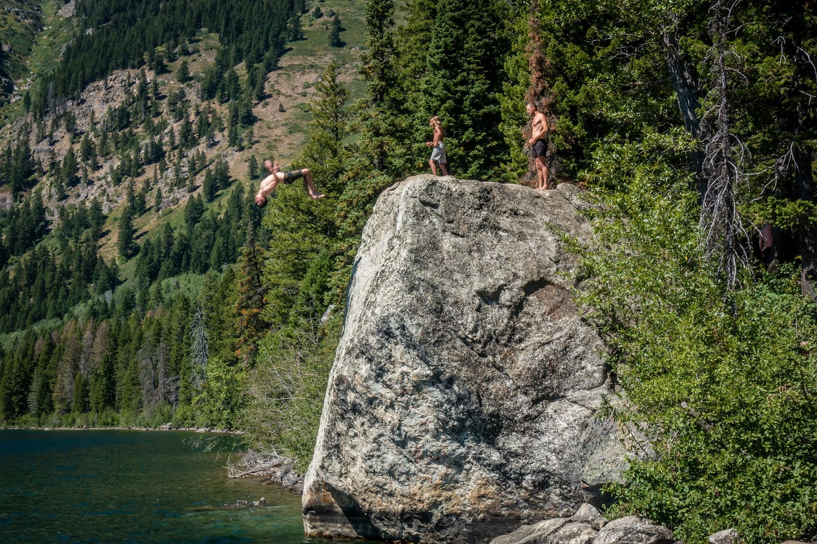
Most of the way up the western side of the lake, we came upon a large group of people that were jumping off a huge rock into the lake. The drop looked to be in the 25 to 30 foot range but the face of the rock wasn’t vertical so divers needed to push themselves out away from the rock in order to clear the rock and hit deep enough water. Since I don’t swim, I had no reason to want to try this but it seemed like those that were jumping were waving a blast. On the north end of the lake is a small beach area where another large group of people were enjoying the water in a safer manner. We weren’t looking forward to the climb back up to the overlook especially since we were about 6 miles into the hike when we got back to it. We took our time, stopped many times along the way and made our way back to the top. The mile downhill at the end of the hike even seemed like work but we made it to the car and then slowly drove down the “road” until we hit pavement.
 |
| Backflip off Rock |
 |
| Running Off Rock |
 |
| Just before Splash |
 |
| Phelps Lake Hike Track |
The next morning, I got up and opened the shades to find the three bull moose from a couple days earlier were back! I grabbed my camera and headed out to see if I could get some shots. They seemed to be in less of a hurry this morning as they slowly came thru our loop.
After a few minutes, I realized they were heading right towards our rig! One headed to the driver’s side and was so close to the motorhome I was worried he might try to rub his antlers on our slide. Chris was watching from inside and at one point could have opened the window and touched him. The other two had gone around the other side and seemed to be checking out our mountain bikes leaning against the picnic table.
After a couple more minutes, the solo guy headed around the back of the rig to find his buddies before they crossed the road and left our rig unscathed. I stayed out to get a few more shots as they headed towards the river. This was a very special experience we likely will never have happen again.
We still wanted to take the time to check out Mormon Row. This is an area where numerous Mormon homesteads were established in the 1890’s. Some of the buildings are still standing and are rather famous. You likely will remember seeing pictures of the barns with the Tetons in the background even if you didn’t realize where they are located. Had I been ambitious, I would have gotten over here at sunrise when the lighting would have been more dramatic but that never happened. It is a popular place for visitors but the buildings are spread out enough that I wouldn’t consider it crowded.


We managed to get in one more good hike in GTNP before leaving. Taggart and Bradley Lakes are situated about halfway between Jenny and Phelps Lakes. There is a fairly large parking lot right off the main park road at the trailhead. Being a loop trail, shortly after starting you get a choice. Both directions will get you to Taggart Lake. We pick the Beaver Creek Trail to the left if for no other reason, most people went the other way. The views of the Tetons along this trail are impressive. Taggart Lake was bigger than I was expecting but just as pretty as I hoped.
 |
| Taggart Lake |
We followed the trail along the southern shore but then continued to follow the trail along the eastern shore rather than taking the loop back to the parking area. Continuing on to Bradley Lake will take an additional 2 miles but in our estimation it was worth it. We found a spot overlooking Bradley Lake to eat our lunch before exploring more of Bradley Lake on its north end. We followed the other half of the loop back to the car and ended up with about a 7.5 mile hike with 1000 feet of elevation gain.
 |
| Bradley Lake |
 |
| Taggart & Bradley Lake Hike Track |
On our last full day at Gros Ventre, we woke up to find moose again. Not the three young bulls but a larger bull and his mate. The two of them were in the middle of our campground loop and after eating some bushes, they both bedded down for a rest. They drew a lot of attention from the campers but seemed to be used to the commotion of all the people trying to get close enough to take a cell phone picture. They only moved a couple of times and hung around the area for over two hours. We actually grew tired of watching them and decided to go for a drive on the north end of GTNP.


We drove up to Colter Bay Village and did a short walk near the marina and a loop trail that had nice views of Jackson Lake. We also stopped at Jackson Lake Dam and Chapel of the Sacred Heart. We had planned to drive up the road to the top of Signal Mountain but for some reason the rangers had just closed and locked the gate so we missed out on this. All in all we enjoyed our stay at Grand Teton National Park. And even though it wasn’t “planned” and likely couldn’t be repeated, the highlight had to be the three visits of moose in the campground.
 |
| Jackson Lake |
 |
| Marina |
 |
| Jackson Lake Dam |
 |
| Chapel of the Sacred Heart |