Map of this blog's locations click this link to open the map
With only a week left of our monthlong stay in Kremmling, we find there are still lots of things we had wanted to see or do in the area but just hadn’t gotten around to them. It’s unlikely we will squeeze them all in but we shall try. The first is another hike near Rabbit Ears Pass. AllTrails calls this the Wyoming Trail Loop and starts at the exact same parking area near Dumont Lake that Rabbit Ears Peak Trail begins. It’s just under a 7 mile loop and nearly 800 feet of elevation gain plus it tops out at over 10,300 feet in elevation so it should be a bit of a workout for us.
 |
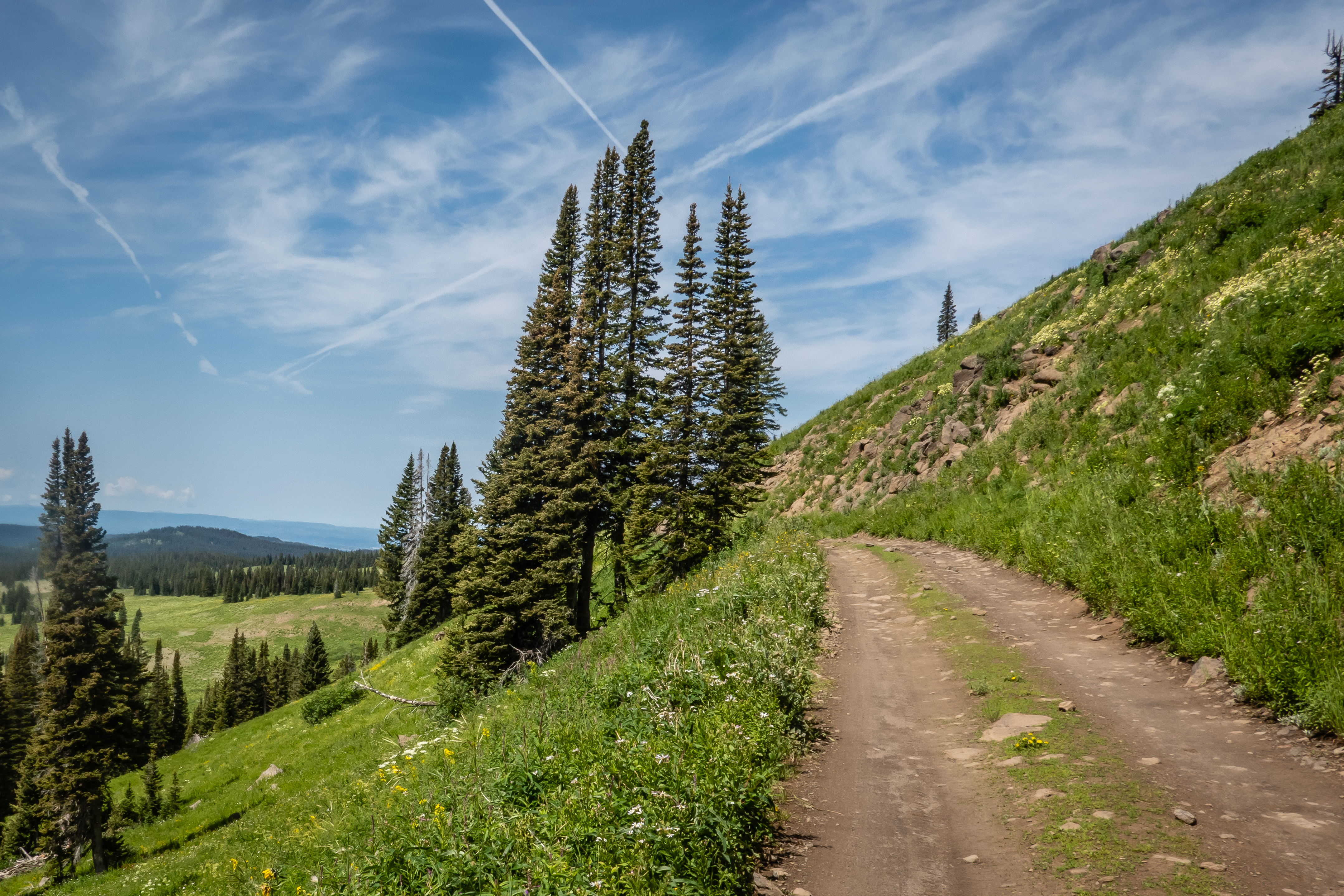
| View Starting Up Base Camp Road |
We do the loop in a counterclockwise fashion which has us heading up the trail which is actually a dirt road (Base Camp Rd) for about 3.5 miles. This is the road we nearly mistakenly headed on a couple weeks ago when hiking to Rabbit Ears Peak. It would be an easy error to make since the beginning of each trail nearly parallels one another but ends up about a half mile apart. As far as dirt roads go, this one wasn’t too bad since the views got increasingly better as we rose in elevation. There were a few mud puddles but none that we couldn’t easily get around. We caught up with a group of people that believed they were headed to Rabbit Ears. They were already a mile into the hike and were disappointed when we informed them this was the wrong trail. From the overlook we were at, we could see Rabbit Ears in the distance and they decided to cut across the field and hope to hit the proper trail without coming upon any difficult obstacles. |
| Indian Paintbrush |
 |
| Muddy Section |
 |
| Hikers Hope to Get to Rabbit Ears Peak |
We continued up the road and were a bit surprised to hear a car coming up behind us. The road was in pretty good shape for a hike but not so much for vehicles but the Subaru that passed us seemed to be doing okay. The road turns to the west and is most of the way up the side of a hill. The views over the valley below were quite nice. The high point of the full trail comes in at about 2.7 miles up the road. Another car passes us but this time a Jeep that looked to be better suited for the conditions. There were lots of wildflowers in bloom, in fact our timing for them might have been better than our nearby hike about 2 weeks ago. |
| Butterfly |
 |
| Continuing Up Base Camp Road |
 |
| Nearing the Highpoint |
 |
| View from Up High |
 |
| Butterfly |
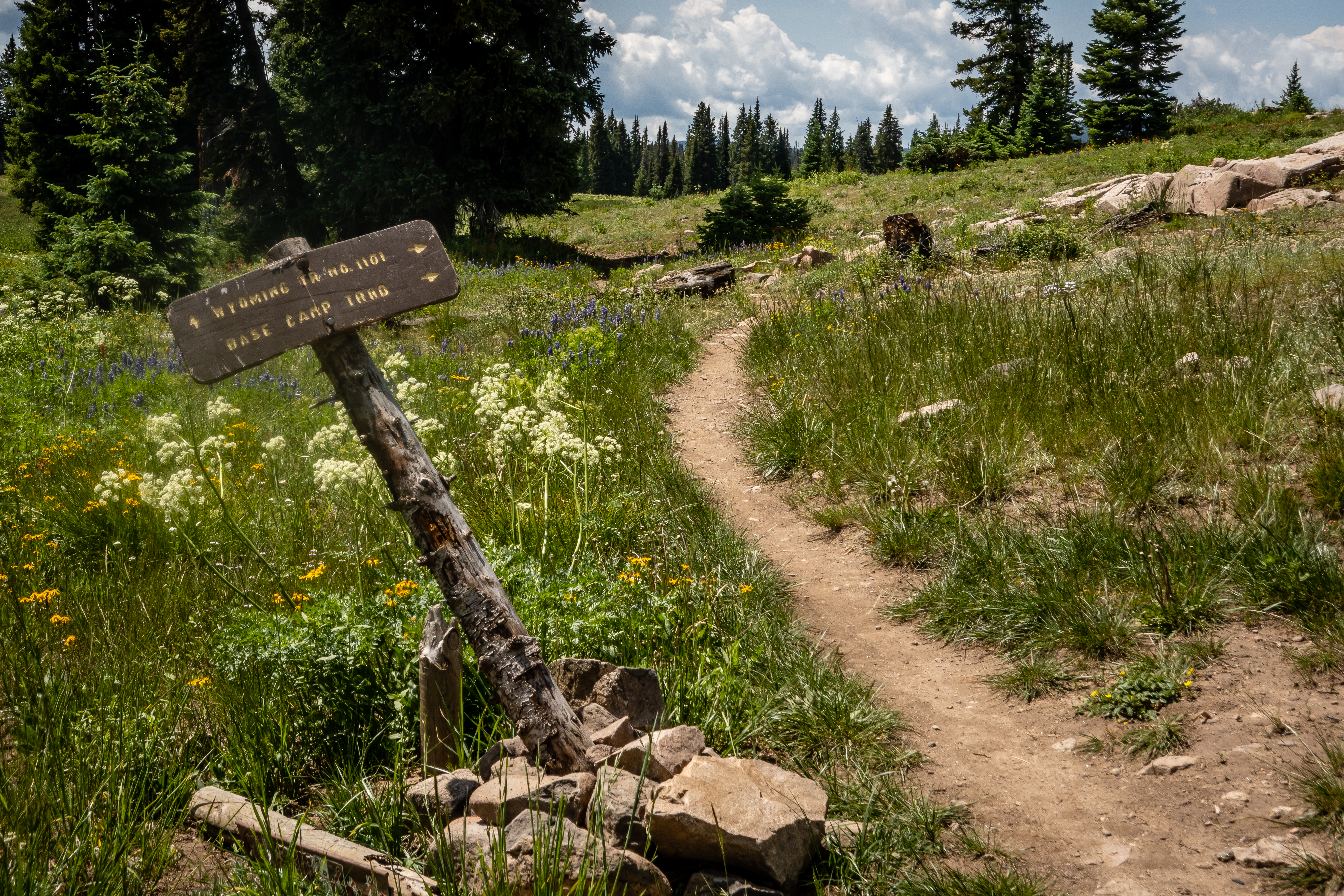
Just past the high point is where Muddy Creek starts. We could see where the creek is, but there wasn’t any water flowing up here. We can see Dumont Lake about 1.5 miles away and 800 feet below us. We find the intersection for the Wyoming Trail and start our journey south. We find a rock outcropping with a great view and use that as our lunch spot. While we were eating, four horseback riders passed by us coming up from the lake. |
| Loads of Wildflowers |
 |
| Overlooking Dumont Lake |
 |
| Intersection with Wyoming Trail |
 |
| Riders Heading Our Way |
After lunch we continued our hike down. The trail went thru both wooded sections and wide open meadows just full of wildflowers. It was a pretty hike. We eventually get close enough to the lake to get a good view. There was a rather steep and rocky descent to get down to creek level and we were surprised to see a fair amount of water flowing in Muddy Creek into the lake. Since there wasn’t water in the creek near the top, it wasn’t clear how so much water was coming down the valley. The trail along the northern side of the lake gave us a chance to see a few paddle boarders out on the water enjoying a very nice day. The trail works thru the campground area and we tried to find a geocache hidden near a campsite but didn’t find it. We suspect that given how close it was to a site, some camper likely found it and assumed it was trash. As we got back to the car, the four riders were just getting into the parking are to be loaded onto their trailer. This was a nice hike with a varied terrain and not very crowded since most people here head to Rabbit Ears Peak. |
| Field of Wildflowers |
 |
| Butterfly |
 |
| Getting Closer to Dumont Lake |

Our next hike would take us south near Frisco again. It may seem like we are simply alternating between hike to the north and hikes to the south but sometimes the afternoon showers that we have grown accustomed to are more likely in one spot versus the other so we will also use the weather forecast as a guide to tell us which way to head for a given day. Our goal for this hike it to check out Lily Pad Lake. There are a few trail option that reach the lake but we choose to get there via the Meadow Creek Trail. The trailhead for this hike is also just off an exit of I-70 but one exit east of the last hike down this way. It was a very crowded parking area but there are additional spots along the dirt road into the lot.
Starting so close to the busy interstate, this trail is quite noisy. The first half mile or so is rather steep and rocky as well with an average grade of 13%. At the trail intersection at 0.6 miles we head to the right to continue to the lake. By now, we are far enough from the road that noise is no longer detracting from the pleasure of the hike. There are some views along the way of Dillion Reservoir but for the most part this is a hike in the woods. |
| Butterfly |
 |
| Dillon Reservoir |
At about 1.5 miles in, we come upon Lily Pad Lake. It’s a 2 to 3 acre lake that does have some lily pads around the shore, but there weren’t as many as we were expecting given the name. But it is still a very pretty setting for the lake and we sat down to have our half of our lunch. There were quite a few people around the shore but it’s a big enough area that it doesn’t seem crowded. |
| Lily Pad Lake |
 |
| Duck On the Move |
There were more people along the north side of the lake and we knew one of the other routes to this lake comes in from that direction so we head over to check it out and possibly hike some of that trail since this was going to be a short hike. It was then we realized that there was another smaller lake just north of the first lake we spotted. This one is nearly completely covered in Lily Pads. We enjoyed the view here for a bit before heading up the continuation of this trail. |
| Nearby Lily Pad Covered Lake |
 |
| Almost in Bloom |
 |
| Another Lily Pad Lake View |
We went for about 1/3 mile but weren’t finding any really special views from this side of the lake either so we headed back to the bigger lake and finished the rest of our lunch. This area was overrun by chipmunks all trying to get a handout from the couple dozen hikers scattered about the shoreline. A couple women near us were feeding the little guys and the chipmunks would sit on their legs or shoulders while being fed - it was entertaining but we weren’t willing to share our food. The hike back down went okay and it was easy to tell when we were getting close to the parking area simply by the volume of road noise. |
| Deep Purple Flowers |
 |
| Cascade on Meadow Creek |
Having done hikes on back to back days, we were looking for something different to do. We hadn’t driven up to Berthoud Pass yet and we felt we should give it a try. It is a bit over an hourlong drive to this Continental Divide pass. We made a few stops along the way to find some highly favorited geocaches but really didn’t explore the towns of Maryvale or Winter Park. |
| View in Maryvale Going for Geocache |
It was a very pretty drive and we definitely got up there in elevation. We made a longer stop before we made it to the top of the pass. We had picked out a somewhat shortish trail of 2.3 miles and only 740 feet of elevation gain. Of course the trail would be starting at 10,600 feet and getting up to 11,300 feet so we needed a short trail to compensate for the thinner air up here. The Second Creek Trail will take us up to Broome Hut which I assumed was some sort of warming hut for cross country skiers. |
| Second Creek Trailhead |
The trail wasn’t overly steep but it was fairly rocky although the real problem for us was the elevation. We found ourselves needing to stop frequently just to catch our breath. There are definitely some nice views along the way so stopping to take pictures helped in that regard. Along the way, we were passed by a family walking back down to the parking area. Their curious gear included pillows - not something we see everyday on a hike in the mountains. |
| Rocky Trail |
 |
| Small Cascade |
 |
| Colorful Mushroom |
 |
| Nice View |
 |
| Still Some Snow |
About 3/4 mile up the trail was a geocache but it was hidden a few hundred feet off the trail. We found a reasonable approach to ground zero and we’re struck by the beauty of the location. We were overlooking a valley where First Creek flows. As I took pictures, Chris looked for the cache. I was hoping she would find it without my help but I needed to start looking as well. We had to go down the side of our drop off in order to spot the well hidden cache. |
| Head Up There for Geocache |
 |
| Great View from Cache Location |
We worked our way back over to the main trail and continued up. There were wonderful views throughout this section with mountains on one side of us and a valley in the other direction. As we came around the corner, we spotted Broome Hut. It wasn’t at all like we were envisioning. It was big - maybe 1600 square feet! There were a dozen or so people out and about. We spotted a picnic table on a hill overlooking the place and sat down for lunch.
 |
| A Little Snow Remains |
 |
| Broome Hut |
 |
| Picnic Spot |
After lunch, we walked down to the hut to check it out. About 1/3 of the place was open to the public during the day. Inside there was a small kitchen area, picnic table and some platforms that appeared to be where one would spend the night in your sleeping bag. The other side of the building was closed off and looked like it could be reserved. I didn’t investigate how many people could use the place but it looked like quite a few. We weren’t going to stay long enough to need to know. The walk back down was much easier on the lungs. |
| Inside Broome Hut |
 |
| Creek Near Hut |
 |
| Heading Back Down |
We continued on up to Berthoud Pass - elevation 11,306 feet. There is a very large parking area on the east side of the road. There are trails on either side of the road that lead up the two mountains that the road passes through. The one to the east looked a little daunting since it seemed to just head straight up the mountain towards a large number of communication towers. The trail to the west was a bit nicer looking up into some woods. There were 2 geocaches along the Berthoud Pass Trail and fortunately they were within the first 3/4 miles. This trail starts at the same elevation as Broome hut and we need to climb about 400 feet to find the two caches.
 |
| At Berthoud Pass |
 |
| Trail on East Side to Towers |
We seemed to be moving in slow motion for this hike. We needed to stop frequently to catch our breath, but the views were breathtaking. As we approached the second cache, two riders on horseback were heading down the mountain. We got off the side of the trail to be out of harms way. The first guy looked to be a ranger with uniform and badge. He had another horse tethered behind that had large packs. A border collie was running along with them and barely even acknowledged our presence. Hopefully they were doing some trail work instead of delivering mail. After they passed we found the cache and went uphill a bit further before realizing the view probably wasn’t much better if we hiked another half mile so we head back to the car. |
| Starting Up Berthoud Pass Trail on West Side |
 |
| Ranger on Horseback |
 |
| Great Views Up Here |
From Berthoud Pass, we had two options. Head back the way we came for about a 60 mile drive or proceed over the other side and head down to I-70 to Silverthorne and back about a 78 mile drive. Since this was the road and pass we had avoided a month ago on our drive to Grand Lake in the motorhome, we thought it would be worth checking it out. We made a few stops along the way to take in some sights and try for a few more geocaches. One stop was at Berthoud Falls. We didn’t find the cache but did enjoy the view. Another stop was at Coors Falls. The parking area was small and I didn’t see any signs to denote the stop. There were a couple of small falls within a hundred feet of one another. It was a neat stop but by now it was getting late and we were getting hungry. Instead of driving home for dinner we picked a brewery in Dillon that looked good. We enjoyed good food and a beer at Dillon Dam Brewery before heading the rest of the way to Kremmling. So now that we have driven this pass in the car, could we have done it with the motorhome? Yes, there were plenty of trucks taking this route and it wasn't as bad as the map made it look. If we were heading this way again, would we take this route? Probably not, while we "could" do this route with the motorhome, I would still prefer the route on I-70 thru the Eisenhauer Tunnel. That was a very pretty route and one that I could enjoy the views. |
| View Along the Way Down |
 |
| Berthoud Falls |
 |
| Coors Falls |
 |
| Another Section at Coors Falls |
We’ve been here 4 weeks already but there were still a couple of places we hadn’t checked out yet. The first is the cliff that sits just to the north of Kremmling. I didn’t hear anybody call the cliff by a name but it is an impressive feature of town. It’s about 3/4 mile long and 300 feet tall. County Road 227 leads to the top of the cliff. It’s a rather dirty, rocky and bumpy drive. We stopped first at the point to the west of the cliff where we believe the fireworks had been launched from on July 4th. |
| Kremmling Cliff from Town |
 |
| View from Fireworks Launch Site |
 |
| View of Cliff from Fireworks Site |
The road wasn’t for the faint of heart and Chris was not thrilled about the last portion of the drive to the top of the cliff. Mind you, there are no guardrails to prevent us from simply driving off the cliff and dropping into the Muddy Creek below. This creek definitely meanders quite a bit as it passes town on its way to join the Colorado River. Chris was careful to stay way back from the ledge. I was careful as well but willing to get much closer to check out the views. This is another good spot to see Gore Canyon in the distance. Chris wouldn’t let us drive to the western end of the cliff where there may have been a turn around point so I needed to make a multipoint turn on the narrow dirt road in order to head back down. |
| An Indecisive Muddy Creek |
 |
| View North of Wolford Mountain |
 |
| Gore Canyon in the Distance |
A bit further up the road from the cliffs is the Ritchard Dam which creates the Wolford Mountain Reservoir. We’ve passed by this place numerous times but have never bothered to stop. There is a geocache near the parking lot so that gave us a bit more incentive to stop here. The water level did look lower than normal but it isn’t clear whether the level varies this much over the course of the year or if the level has been low for an extended time. It was neat to walk around and check out the views. It doesn’t look like this is a hydroelectric dam but the water does come out of some pipe near the downstream side of the dam with quite a large stream.
 |
| Wolford Mountain Reservoir |
 |
| Water Released Through Dam |
 |
| Walking Across Ritchard Dam |
 |
| Backside of Dam |
Since we still have our Colorado State Park pass, we headed over to Stagecoach SP. The park features a nearly 200 acre lake with several trails. From what we could tell, we could string together some of the trails and circle the lake. It would be about a 10 mile route that could be done by bike. The trail conditions sounded favorable for our style of riding but there is 750 feet of elevation change so we shall see how the hills impact us.
 |
| Creative Sign at Stagecoach SP |
We parking in a lot just outside of the McKindley campground and pick up the trail in a counterclockwise direction. Given this first section of trail was called the Overlook Trail, it shouldn’t have been a surprise that it was a good uphill climb. It does provide a nice view of the lake and surrounding mountains. At just under 2 miles in, we need to ride on the county road for a quarter mile before heading around the southwestern end of the lake. |
| Heading Down Path |
The Elk Run Trail follows the southern shore of the lake for roughly 5 miles. It goes past a couple of small coves and a boat launch. There are a few short but steep hills. If you’re willing to gain as much speed as possible, you’ll make it up the hill otherwise you’ll need to walk the bike a bit. As we come around the last cove, we can see the dam at the far northeastern end of the lake.
 |
| Looking Back Across the Lake |
 |
| Approaching Dam |
We spent 15 minutes searching for a geocache hidden nearby the dam but with all the rocks, there were way too many hiding spots so we gave up to continue on. There is a small walkway over the dam with a scary sounding caution sign but weather conditions made for a safe crossing. The dam does house a small hydroelectric power plant and lots of water flowing thru the turbine.
 |
| Water Through the Dam |
 |
| Not Dangerous Today |
 |
| Looking Back to the West |
It was a rather warm afternoon but we found a building just up from the dam that we could sit in the shade to eat our snack. From this point, we need to ride on a dirt road back towards the entrance. It was wide and in pretty good condition. Only a few cars passed by so traffic was not an issue either. We made it back to the car after a fairly nice bike ride. Then we drove to the marina/campground/beach area and found a picnic table to eat the lunch we had brought with us. Being a Saturday afternoon the beach and rest of the park were rather busy but not annoyingly so. |
| Beach at Stagecoach SP |
We took a slight detour to the west in order to get a cache in another Colorado county we hadn’t gotten to yet. It is definitely a lonely part of Colorado but still pretty. On the drive back to Kremmling we saw Finger Rock and had to take a picture. It’s not clear which finger it being held up. |
| Finger Rock |
For our last full day after a month, we head back up near Rabbit Ears Pass for one last hike. Windy Ridge is a 5.5 mile out and back trail with a little over 700 feet of elevation gain. Fortunately it isn’t quite as high as the others we have done nearby with it peaking out at 9,600 feet. The trailhead parking area is about 1.25 miles down a very rough road. It appears to be some sort of dispersed camping area and there were a fair number of trailers. It was a fairly nice weekend but this would be a very tough drive if conditions were wet. There are a handful of cars at the parking area as we start out. The first 1/3 mile is uphill followed by a 2 mile downhill. |
| Along Windy Ridge Trail |
 |
| Mushroom |
We run into several very wet areas on the trail. Limbs and rocks have been tossed into the muddy water but the crossings aren’t super easy unless you don’t mind wet feet. As we come out of the woods, we are met with a large open meadow that follows a ridge. It wasn’t a windy day but it was clear why the trail might be named Windy Ridge. There are some nice views in either direction. To the east are some distant mountains and a couple of nearby lakes. To the west is generally a large wooded area on a large hillside. It was quite pretty.
 |
| A Very Wet Crossing |
 |
| Coming Out on the Ridge |
 |
| Lake to East of Ridge |
 |
| Forest to the West |
As we got to the far side of the ridge, we were trying to figure where we wanted to head. My Garmin showed a trail heading towards the pond but we were not seeing it in person. Another hiker was heading back and we asked her what she found in the direction she came from. Apparently there is an old mine in the area up the hill on our left. We decide to check it out and make the climb up the very rocky trail.
 |
| Loose Rocky Climb |
Another hiking group we just leaving as we got near the top. I never did find a mine but the debris definitely looks like it was removed from somewhere and piled here. There was one large rock that jutted out over the valley below. I went out a safe distance but even I wasn’t willing to go to the tip and look over. Rabbit Ears Peak is about 6 crow miles away and we can just make it out from here. We ate our lunch up here and looked around a bit but when we heard thunder nearby we decided it was time to start to head back. It was a long walk back up the 2 mile stretch of trail that was now uphill. We managed to make it back to the car before any rain came and even made it out of the rutted road. |
| Large Rock Juts Out |
 |
| Rabbit Ears |
 |
| Starting Back Across Ridge |
I think we surprised ourselves with just how much we found to do in the vicinity of Kremmling. I won’t say we exhausted all the possibilities but we did a pretty good job of enjoying the area. From all the people we have spoken with during our stays in Colorado so far, many of them have told us how much we are going to like our next destination - Buena Vista Colorado.