Map of this blog's locations click this link to open the map
After our overnight at the Cabela’s in Lexington Kentucky, it is only 110 miles to our next stop in the Cincinnati area at East Fork State Park. This tends to be a popular destination for us having stayed here twice since going full time and twice prior to our homeless travels. There are a few reasons we like this campground. First it is close to some of my family. With two of my sisters and several of my nieces and nephews in town, we enjoy the chance to have mini family gatherings. Plus I went to college in town so I am familiar with the area from 40 years ago and need to get my Skyline Chili and Graeters Ice Cream fix taken care of! We generally enjoy camping in state parks and this one is big with lots of trails, geocaches and campsites. Unfortunately, of the 400 plus campsites in the park, only 23 of them are full hookups while the others are electric only. Of course we didn’t make our plans early enough to snag one of the FHU sites. In fact, we were unable to score one site for the full 13 nights we planned on staying here so we were forced to reserve 2 sites - one for 6 nights and one for 7 nights. I suspect that our stay occurring over Memorial Day weekend didn’t help! It won’t be a big deal since the travel distance will be measured in a couple of miles and we will get a chance to dump our holding tanks midway.
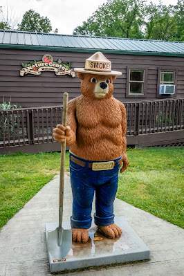 |
| Smokey Bear at Nature Center |
It looked like the extended forecast had for a fair amount of rainy days, so we took advantage of our first full day being decent weather to get in a hike. Just up from our campground loop is Loop A which is the horse camping loop. There are 22 miles of bridle trails in the park and one of the main trailheads is out of this loop.
 |
| Bridle Trailhead |
There are several dozen geocaches to be found along the horse trails but from past experience with hiking on them here, they can be extremely muddy - like suck your boot off your foot muddy! We figured that if we were going to be able to get in some hiking, we should try them before more rain moved in. We were able to just walk down from our campsite to start the hike. We discovered that the trails were in reasonably good condition and managed to get in around a 5 mile loop finding 13 of the 15 geocaches we attempted. That evening, we treated ourselves to a dinner at Skyline - the first of several stops here during our stay.
 |
| Wet Trail |
 |
| Pond |

We did get a fair amount of rain the next day so I was glad we managed to get some of the caches along the horse trails found. We spent a few days visiting with family. We had told my youngest sister to come up with a list of things she needed done around the house. We figured working on household jobs would be good practice for our upcoming Habitat for Humanity build we are scheduled for in late June. It was a varied list from some electrical changes, to woodworking, and simple moving of furniture. Nothing Chris and I couldn’t handle. I even was able to pull out my Tormek knife sharpener and sharpen all our knives. I must have done a good job since both my wife and sister nicked a finger in the next few days.
With another nice day of weather, we head out for a hike on a portion of the Steve Newman Worldwalker Perimeter Trail. This trail is 33 miles long and, as expected, goes around the perimeter of the state park. We know we aren’t doing the full trail, but we can walk from our campsite down the bike trail and over the dead end road that runs into a portion of the park before hitting a section of the perimeter trail. We had apparently timed our visit here to coincide with one of the cicada broods emerging from the ground. They were everywhere and in different part of the park, their noise was extremely loud.
 |
| East Branch Little Miami River |
 |
| Cicadas |
The part of the Perimeter Trail we took would lead us back north towards the campground area. This trail was pretty overgrown in parts and often wet and muddy but at least it wasn’t rutted up like the horse trails were. We came upon one group of guys with backpacks and camping gear. We suspect that they were going to take advantage of the Memorial Day weekend to hike and camp along this trail.
 |
| Overgrown and Muddy |
 |
| Creek Crossing |
We had plenty of geocaches to find along the hike. There is one cacher that has hidden the vast majority of ones in the park. He has hidden several thousand caches over the years so there is never a lack of hides to find when we revisit the area! Our hike came in at just over 5 miles and only got a little bit muddy along the way. Another 16 finds for us on this hike.
 |
| Another Water Crossing |

We moved sites on the Saturday of Memorial Day weekend. Probably not the best idea since the park was nearly full and we needed to have one person move their truck for us to safely back into the new site but at least we dumped our holding tanks and refilled our fresh tank. A couple days later, we head out for another hike on a portion of the Perimeter Trail in a section of the park we have never visited before. The section is on the opposite side of the East Fork of the Little Miami River and was best accessed by Twin Bridges Road south of Williamsburg Ohio. It was a very rural area and the road ended at the parking lot for the trailhead. We never saw any bridges but a little research explains that there was a bridge over the river further along this road. But when the dam was put in back in the 1970’s, this bridge and many other structures were submerged. We start out heading south and find the trail in fairly good shape but definitely not as well maintained as more accessible portions in the heart of the park.
 |
| Tree Obstacles |
We made it a little over a mile and found 4 of the 5 caches we looked for before we made it to a section we had hiked way back in July of 2016. We did run into one area where there was a large field that looks like it is sometimes farmed. We ended up losing the trail and sort of wandered around the perimeter of the field until we realized the trail goes through the field and is obscured by seeing so little foot traffic. The plan was to make our way back to the car and proceed to the north but I received a text from my sister asking us to come over that afternoon so we changed plans and went back to the rig to clean up and head out.
 |
| Where'd the Trail Go? |
 |
| Creek Crossing |
 |
| Trail Through Field |
We spent a couple more days visiting with family before we get a chance to go out for more hiking, caching and sightseeing in East Fork State Park. The park was developed as part of the aforementioned dam built for flood control in the area. In all our times staying in the park, I can’t recall ever visiting the dam. It’s in the southwestern portion of the park and does require leaving the campground area and driving outside of the park to get there. Our first stop is at a parking area near the Perimeter Trail. Surprisingly, there are not all that many geocaches hidden on this side of the park, maybe that’s why we haven’t visited before?
 |
| Getting to the Trail |
 |
| Nice Woods |
It was a pleasant walk in the woods with a couple small creeks along the way. We found two of the caches without a problem but the one a mile or so down the trail was near a creek bed. The only problem was at the closest point, the trail was about 30 higher than the hide and with all the recent rain, the steep, rocky descent looked too difficult to attempt. The trail eventually got us down to creek level but now several hundred feet away. The creek was fairly low and there seemed to be enough rocks along the way to carefully walk up to the hide. It was slow going since it was quite slippery but we made it without twisting an ankle or worse. The cache was hidden just below a small waterfall and we found a side trail that made for a much better exit than walking the creek bed. We made much better time walking back to the car once all the caches had been found.
 |
| Large Mushroom |
 |
| Falls Near Geocache |
 |
| Rocky Creek Bed |
We drive up to the visitor center for the dam and eat our lunch in the parking lot before checking out the displays inside. While the park is state run, the dam facilities fall under the control of the US Army Corps of Engineers. There are lots of animals from the area hanging on the walls as well as a fair amount of information about the development of the dam and how it is used for flood control.
 |
| Visitor Center |
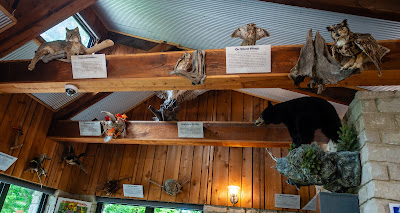 |
| Assorted Animals Above |
As we leave the visitor area, we see a sign for one of the boat ramps. We drive down and check it out. It wasn’t very busy but one guy was in the process of launching his boat.
 |
| Boat Ramp |
Our last stop of the day was to the tailwater section just below the dam. This was not built for power generation so it is a rather simple design with a 40 foot wide, concrete tunnel sticking out of the earthen dam. There were a fair number of people sitting along the outlet with fishing poles hoping to catch dinner. The Tailwater Trail starts out of the parking area and had a few geocaches for us to find and we got in another 1.5 mile walk in the woods.
 |
| Dam Outlet |
 |
| A View Down the Outlet |
We were getting down to our final days at East Fork. Just down from the campground at its boat launch is the Fern Hill Trail. It’s only a 1.5 mile loop but does have 7 geocaches along it. We were wanting a longer hike so instead driving down to the trailhead, we decided to walk the mile and a quarter to Loop K which also has trail access. It was a nice peaceful walk in the woods and being a Thursday morning, there were no other hikers to be found.
 |
| Mini Mushrooms |
When we got to the southern end of the loop, we decided to get sidetracked and see this boat ramp area. There were only a couple of boat trailers and trucks parked in the lot. One guy was just putting his boat in and we watched him for a bit. The boat ramp has a small dock to the side but this was a floating dock. That in and of itself isn’t too unusual, but the poles driven into the water had to be close to 40 feet tall. They seemed to be way too tall. We talked with the fisherman and asked him about them and mentioned that yes the water does sometimes get that high. We were even able to see rub marks on the poles way up there. I knew the Cincinnati area had a lot of flooding this past spring, but I had only seen video from the downtown area of the Ohio River flooding out parts of town. I latter checked out the COE website with the historic water levels for this lake. On the day we were there the water level was at 733 feet above sea level. But back on April 9 of this year, it was at 763 feet. A full 30 feet higher!
 |
| Campground Boat Launch |
The campground beach area is nearby so we head there to see what it looks like and have our lunch we were carrying. It was clear that there had been a lot of flooding and signs that the cleanup was still underway with piles of driftwood all over the area. Thinking back to the day we sat there on the beach, it’s unimaginable to think this was under 30 feet of water.
 |
| Newly Place Straw |
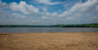 |
| Campground Beach Empty |
We headed back up from the beach and resumed our hike on the Fern Hill Trail to finish off the other half of the loop. It was a fun hike but the mile long walk back to the rig afterwards wasn’t the most enjoyable. In total we got in a little over 4 miles and found 7 caches.
 |
| Mini Trail Bridge |

On our last full day, we had some family visit us at the state park. Since we were in the loop with the nature center and playground, my niece’s young children enjoyed a brief time playing with other kids from the campground. Of course, we ended up having a popup shower catch us off guard and we all got pretty wet before we could make it back to the motorhome. That evening, we met my sister and brother-in-law at Jungle Jim’s International Market for drinks. I’ve mentioned about this place in a previous post as to being a very unusual grocery store with aisles of food from all over the world - from ostrich eggs to alligator meat and just about anything else you may think of. It may seem like an unlikely place to meet for drinks, but their beer department also has a bar with a wide variety of beers on tap. The line on a Friday night was crazy long but it moved reasonably quickly and we had a nice time. On our way out, we wandered around the store some to see if there was something we needed that we would never find anywhere else. We did find one of the beers I used to drink during my college days but is very hard to find anymore - Little Kings. We discovered they have a large section of kitchen knives as well. The area wasn’t open this late in the evening but we could still look at the displays. Of the hundreds of knives, the one costing $599.99 caught my eye!
 |
| Expensive Kitchen Knives |
Our next reserved stop was in far northern Indiana at Indiana Dunes State Park campground. Since it is over a 300 mile drive from the east side of Cincinnati, we had planned an overnight stop in Anderson Indiana - northeast of Indianapolis. Harrah’s Hoosier Park Casino Racetrack has a huge parking lot and permit overnight camping. There are no services or utilities but this should work out well for us. After pulling in, I headed out to find geocaches in some of the surrounding counties since we have never been to this part of Indiana before.
When I got back, we found one more Skyline Chili location nearby to get our last Skyline fix. Then we head into the casino - not to gamble but to just see what it was like. This one was like many we have visited with plenty of slot machines and all sorts of poker tables, roulette wheels and craps tables. We passed by all of these and headed to the racetrack section of the complex.
 |
| Harrahs Casino |
They have a very large room with huge windows overlooking the 7/8 mile racetrack. Not knowing anything about harness racing, we sat and watched several races to get a sense of how it works. It was kind of exciting to see how the teams warmed up a bit before trotting behind a pickup truck with a starting gate attached. As they went by our viewing area which is the start and finish line, the gates retracted and the pickup truck sped off, and the teams flew by. There are lots of monitors showing the horses as they circle the far side of the track and the large display with the order of the horses and the announcer keep the people well informed. After each race, the winning team came over to the viewing area for pictures and the winning purse. Then the tractors went out and did multiple laps around the course smoothing out the track for the next race. It was neat to watch but we were not tempted to place any bets.
 |
| Inside Viewing Area |
 |
| Approaching the Finish Line |


