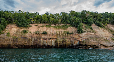
What will likely be one of the highlights of this whole trip was the full day we spent visiting Pictured Rocks National Lakeshore. The plan was to get a fairly early start. Not "set the alarm" early, but definitely don't roll back over for another snooze. It was close to a 90 minute drive from our campgrounds with the last few miles being over rough dirt roads.
The parking area looked huge to me given the road we took to get here and there were many spots open. We donned our CamelBacks so we had plenty of water and packed our sandwiches for a lunch. We knew the hike we planned was a 10 to 11 miles long so we wanted to be prepared.
Our first stop was Mosquito Falls. It was a pleasant 1.5 mile walk in the woods and we didn't see anybody until we got to the backcountry campsite there. We explored some of the areas along the shore. It had turned overcast and the winds were whipping which in turn made for some pretty impressive waves crashing the shore.
 |
| Waves Crashing at Mosquito Beach |
 |
| Serious Erosion of the Rocks |
 |
| The Bear Warning Had Us on the Lookout |
 |
| Lover's Leap Arch |
 |
| Us with Arch in Background |
 |
| Another Arch in the Distance |
 |
| Waves Crashing |
 |
| Chapel Rock from the Shore |
 |
| Roots from Pine on Chapel Rock |
After getting turned around a bit at Chapel Falls, we eventually made our way back into the parking lot which was now completely full. In fact as we drove out the dirt road, cars were parked along the one side stretching nearly 3/4 of a mile from the lot! Our total hike was 11.25 miles in about 5.5 hours with a numerous number of photo stops along the way.
 |
| Tree Tenaciously Hanging On near Chapel Falls |
By the time we boarded, the line of people was at least a 1/4 mile long and we ended up filling two of the boats. This worked out well since we were able to pick the second boat and get the prime viewing location for the ride. Our captain was in his mid 20's but seemed to know what he was doing. He did point out that the sees were a little rough and allowed people to reconsider the trip if motion sickness was likely. I think 3 or 4 people got off our boat.
The ride was not that bad and other than some clouds had rolled back in so the sun light might not be ideal on the face of the cliffs, it was a pleasant trip. We got a good lesson about Lake Superior and the rock formations all along the shore. It was interesting to have done our hike earlier in the day and then get to see the same areas from a different perspective.
 |
| Light House on Grand Island |
 |
| Miners Castle |
 |
| Bridalveil Falls No Longer Flow Year Round |
 |
| Incredible Colors from Various Minerals Leaching Out |
 |
| Lovers Leap from Boat |
 |
| More Colors |
 |
| Another Arch |
 |
| Sun Starting to Set Over Arch |
 |
| Chapel Rock from Water |
 |
| Chapel Rock with Roots back to Shore |
 |
| The Sun Sets Over Grand Island as We Head Back |


No comments:
Post a Comment